An Inventory of the Historical Monuments in Dorset, Volume 2, South east. Originally published by Her Majesty's Stationery Office, London, 1970.
This free content was digitised by double rekeying. All rights reserved.
'Lytchett Matravers', in An Inventory of the Historical Monuments in Dorset, Volume 2, South east, (London, 1970) pp. 154-157. British History Online https://www.british-history.ac.uk/rchme/dorset/vol2/pp154-157 [accessed 12 April 2024]
In this section
20 LYTCHETT MATRAVERS (9396)
(O.S. 6 ins. aSY 99 SW, bSY 99 NW, cSY 99 SE, dSY 99 NE)
Lytchett Matravers is a large parish of irregular shape covering nearly 3,500 acres 5 m. N.N.E. of Wareham. It consists of undulating land, rising to a maximum height of 300 ft., almost all on Reading Beds and London Clay with the exception of an area of Chalk in the N.W. The original village presumably lay round the church, at the junction of the Chalk and the Reading Beds, and the earthwork remains there support this. The earthworks at Loop (35) may be the remains of a second early settlement in a similar situation. Dullar Farm, in an almost detached part of the parish to the N., also lies on the edge of the Chalk; though not recorded till 1333 (Fägersten, 112), it may represent another early settlement.
Later development in the heavier clay areas to the S. and S.E. which, to judge by the majority of the surviving buildings, was mostly of the 18th century and after, has produced the present scattered village without any focal point. However the existence of at least one 16th-century house (3) indicates that occupation in this area had started much earlier. The houses are built of cob or brick with thatched or tiled roofs.
The church is the principal monument.
Ecclesiastical
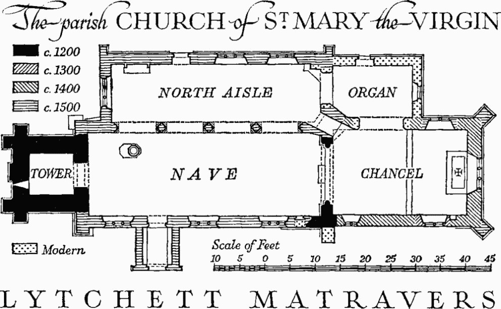
b(1) The Parish Church of St. Mary the Virgin stands near the site of the Manor House to the N.W. of the village. The walls are of carstone rubble with Purbeck and greensand dressings; the roofs are covered with tiles, slates and lead.
The church, consisting of Chancel, Nave and West Tower, was built c. 1200. A North Aisle was added in the mid 14th century, but this and the N. arcade of that date were entirely taken down in alterations of c. 1500. In c. 1400 the chancel was enlarged. Through the benefactions of Margaret Clement (see Brasses, 2) the church was partly rebuilt and improved c. 1500; the work included insertion of a number of new windows and the rebuilding of the N. aisle with the re-use of much of the material of the earlier arcade in the new arcade; the greater part of the S. wall of the nave was reconstructed and the South Porch added. The church was restored in 1873 and the North Vestry and Organ Chamber was added in 1876.
The church is of interest because of the dated late mediaeval work. The Maltravers brass is remarkable.
The Parish Church of St Mary the Virgin, Lytchett Matravers
Architectural Description—The Chancel (26½ ft. by 16¾ ft.) has added diagonal buttresses of c. 1500. In the E. wall is a window of c. 1500, of three four-centred lights in a square head with a label, inserted in an earlier opening, the internal splays and hollow-chamfered rear arch being of c. 1400. In the N. wall is a window of c. 1500 of two two-centred lights in a square head and, further W., a modern opening to the vestry and organ chamber. The S. wall has a reset window of c. 1300 of two uncusped lights and a quatre-foiled roundel in a two-centred head with a label. Further W. is a window of c. 1400 having two trefoiled lights and vertical tracery in a two-centred head. The restored chancel arch of c. 1200 is two-centred and of two chamfered orders springing from chamfered imposts on chamfered responds. From the N.W. corner of the chancel a passage was cut through to the N. aisle when the latter was rebuilt c. 1500.
The Nave (46¼ ft. by 16¼ ft.) has a N. arcade built in Bath stone of four bays with two-centred arches of two moulded orders springing from piers and responds with half-round shafts separated by hollows and with plain bases and moulded capitals. The whole arcade is ill-fitting and of reused 14th-century material except for the capitals. Beneath the rebuilt N.W. angle of the nave appears the chamfered base of a clasping buttress of c. 1200 and traces of the foundation of a similar buttress remain outside the S.W. corner. The S. wall has at the E. and W. ends added or rebuilt buttresses. Near the E. end is a blocked doorway of c. 1500 with chamfered four-centred head, for access to a former rood loft. The three S. windows are each of three four-centred lights with blind spandrel panels in a square head; in the westernmost of them two of the panels contain shields, one charged with the Maltravers fret, the other with the Arundel rudder. Below the westernmost window is a 16th-century oval recess.
The North Aisle (41½ ft. by 11½ ft.) has in the E. wall an opening to the organ chamber, probably modern. In the N. and W. walls are three-light windows uniform with the S. windows of the nave; one of the windows has panels carved with the Maltravers fret, twice, and the Arundel rudder. The N. door has moulded jambs, four-centred head and a label with square return stops.
The West Tower (8¾ ft. by 8½ ft.) is of two stages divided by a weathered offset with three-stage angle buttresses to the lower stage at the W. corners and another small strip-buttress in the middle of the W. wall. The parapet is embattled on three sides and straight on the S. and at each corner is a pinnacle of c. 1500 carved with frets. The ground stage has a restored two-centred tower arch of two chamfered orders springing from chamfered imposts. In the W. wall is a small original lancet window eccentrically placed, with a 14th-century head in a different stone. The upper stage has a small rectangular window in the N. wall. The bell chamber has in the E. wall a window of two cinque-foiled lights, in the S. wall an original window of one trefoiled light and in the N. and W. walls windows of two four-centred lights. The two-light windows are 15th and 16th-century insertions.
The South Porch (5¾ ft. by 7½ ft.) has an outer four-centred archway of one moulded order with a label finished with square stops, one carved with the Arundel rudder.
Roofs: The chancel roof is modern. The nave roof recently had an elliptical ceiling divided into panels by moulded purlins, ridge and transverse ribs. The plaster and ribs have been removed to reveal a trussed-rafter roof of c. 1500 with arch-shaped braces to give the shape of the barrel vault.
Fittings—Bells: six; 1st, 2nd and 3rd all modern; 4th mid 15th-century; 5th by John Wallis of Salisbury, 1616; 6th by John 'Toesser' of Salisbury, 1684. Brackets: In chancel, moulded stone corbels, two in eastern corners and two in side walls; in N. aisle, moulded stone corbel with shield-of-arms of Maltravers; all c. 1500. Brasses and Indents. Brasses: In chancel, (1) in original Purbeck slab reset against S. wall, of Thomas Pethyn, Rector, tonsured naked figure in shroud, and inscription, late 15th-century, with earlier inscription to John Davy and his wife on reverse (Dorset Procs. XLVI (1925), 68). In nave, (2) of Margaret Clement, rectangular plate inscribed 'Hic jacet Margareta Clement generosa specialis benefactrix reedificacionis huius ecclesie que obiit XXIIII die Junii anno domini MoVcV cuius anime propicietur deus Amen'. In N. aisle, (3) of Lettyse Irelond, 1541/2, inscription plate only; (4) probably of John, Baron Maltravers, 1365, large Purbeck marble slab 8½ ft. by 4½ ft. with remains of marginal inscription in French enclosing the indent for a Maltravers fret. Indents: In nave, on S. wall, (1) for small inscription plate. In N. aisle, (2) see Monument (2) below.
Coffin Lids: (1) reused as lintel over opening in N.W. corner of chancel, with hollow-chamfered edge and with parts of an inscription and an incised cross visible, 13th-century; (2) by S.E. buttress of nave, fragment of tapered Purbeck marble slab with hollow-chamfered edge. Communion Table: in N. aisle, with turned and moulded legs, mid 17th-century, (since removed). Font (Plate 8): of Purbeck marble, octagonal bowl with quatrefoil-panelled sides carved with badges of Maltravers and Arundel, a rose and paterae; stem octagonal with panelled sides and with moulded capping above, on original moulded plinth and step, c. 1500. Glass: In nave, in second window, some plain quarries, probably c. 1500. In N. aisle—in first window, two roundels with quarterly shields-of-arms of Trenchard and Mohun (?), 16th-century, repaired; in W. window, figure of St. Anne with a book with inscription, part of a figure of a bishop perhaps St. Denis (Hutchins III, 332) and a figure of St. Thomas of India holding a spear, with inscription, c. 1500, and also roundel with strapwork, putti, fragments of inscriptions and shield-of-arms of Mohun, 16th-century. Graffiti: on nave window jambs, a fret; on S. porch, several late 18th-century dates and initials. Hatchments: in nave, (1) and (2) of Trenchard quartering de Burgh; in N. aisle, (3) and (4) of Trenchard quartering Dillon; all 19th-century.
Monuments and Floor-slabs. Monuments: In chancel, on S. wall, (1) of the Rev. Howell James, Rector, 1850, black marble tablet; in N. aisle, (2) table-tomb of Purbeck marble in front of a recess with flanking shafts and frieze of small quatrefoil panels and embattled cornice, the soffit of the canopy being decorated with blind fretwork; in the back of the recess are indents for a figure kneeling at a prayer desk, a devotional figure and an inscription plate, c. 1500; (3) of Elizabeth Trenchard, 1840, white marble tablet signed Denman, 83 Regent St. London; in churchyard—N. of chancel, (4) of Samuel Conant, 1719, table-tomb with stone top carved with shield-of-arms, set on later brickwork; S. of nave, (5) of Anne Reade, c. 1700, headstone. Floor-slabs: of Purbeck marble, four in nave, and four in N. aisle of which two are carved, each with a large plain shield; all probably mediaeval.
Piscina: in chancel, with hollow-chamfered two-centred head and a shelf, c. 1500. Plate: includes cup and cover-paten, 1574; pewter dish and flagon, 18th-century, (stolen 1964). Royal Arms: over tower arch, primitive painting on wood, of George IV. Stoup: in S. porch, with square head, bowl replaced by modern tiles, c. 1500. Miscellanea: In N. aisle, (1) carved mahogany showcase, containing ivory crucifix, late 18th-century; (2) cast lead panel from roof with names of churchwardens and plumber, H. Bestland, 1771. In gable of S. porch, (3) Purbeck marble cross, reset, mediaeval. In churchyard wall, (4) mediaeval worked stones, reused.
Secular
b(2) Manor House (150 yds. N.E.) was built by an Earl of Arundel before the 17th century (Coker, 86) and was afterwards a seat of the Trenchard family. The main part of the house has been pulled down in modern times and only a part of the E. wing remains; it has been completely remodelled and converted into a modern dwelling. The S. wall is mainly of late 18th-century brick but the lower part is of stone rubble and probably older; the N. wall is rendered in stucco and has an 18th-century doorway with timber architrave. The roof is covered with tiles.
b(3) Eddygreen Farm, house (936952), of two storeys, has cob walls partly faced in modern brick and a thatched roof; it was built perhaps in the 16th century as a single-storey dwelling with a small open hall and one other room. It was divided into two storeys in 1674, the date being carved on a ceiling beam, and later extended at both ends, but the western extension has been demolished. (Burnt 1965)
b(4) Dullar Farm, house (942981), of two storeys with brick walls above a rubble plinth and a modern tiled roof, is of the first half of the 18th century, with small later additions (Plate 44). The front elevation has a brick plat-band and casement windows under segmental brick arches. On plan the house consists of a long straight range of three rooms and entrance stairhall.
b(5) Higher Loop Farm, house (945966), of two storeys with walls mainly of brick covered with stucco and tiled roofs, is of the second quarter of the 19th century. Outbuildings include a Barn, built probably as a stable in the early 18th century, with rubble walls later heightened in brick and with a tiled roof, and a second Barn, mainly of brick with a slated roof, of the late 18th century.
Monuments (6–20)
The following monuments, unless otherwise described, are of cob mostly faced with brick or stucco and with thatched roofs. They are of the late 18th century.
b(6) Barn, at Lower Loop Farm (943967), of rubble and brick with a tiled roof, is probably of the early 18th century, partly rebuilt.
b(7) Cottage (944967) has a central entrance and end chimneys.
b(8) Cottage (949964) has been much altered and enlarged.
b(9) Cottages, a pair (947956), are double-fronted with central entrances.
b(10) Cottage, beside Huntick Road (948953), has been enlarged.
b(11) Cottage, in Foxhill Lane (949951), has a central entrance and end chimneys.
b(12) Cottage (945951) was built as two tenements.
b(13) House (943952) was built as two tenements and has been enlarged to the W.
b(14) Barn, at Spy Farm (942953), has one porch under a continuation of the main roof; the roof trusses have been renewed.
b(15) 'Chequers' Inn (941955) has been much altered and is of uncertain date.
b(16) Cottage (940956) has been extended to the S.W.
b(17) Cottage (937950) has a central entrance and end chimneys.
a(18) House (937948) was built as a small dwelling of two rooms on plan with a chimney at one end and a barn adjoining beyond the chimney. It may be of 17th-century origin.
b(19) Cottages, a pair (930954), are double-fronted.
b(20) Peaton's Farm, house (932958), has base courses of carstone rubble. It is of 17th-century origin but was partly rebuilt in 1758, this date and the initials I P being cut in the brickwork.
Monuments (21–33)
The following monuments are similar to the foregoing but of the early 19th century.
b(21) House, at Castle Hill (945962), with brick walls and tiled roof, has a symmetrical front with central entrance.
b(22–24) Cottages W. of Flowers Drove (947960, 946958 and 956957).
b(25) Cottage E. of Flowers Drove (948959).
b(26–27) Cottages in Lime Kiln Road (946956).
d(28) Cottage, in Wimborne Road (954958), has been enlarged.
b(29) Cottage at junction of Wareham Road and Eldons Drove (945950).
b(30) Cottages (941952), marked 'Meeting House' on old O.S. 6 in. map, are of brick with tiled roofs.
b(31) Cottage (942953).
a(32) Foxhills Dairy, house (948933), has modern buttresses added.
c(33) Hill Farm, house (954930), of brick with a tiled roof, is of the second quarter of the 19th century.
Earthworks, Etc.
Mediaeval and Later Earthworks
b(34) Settlement Remains, formerly part of Lytchett Matravers village (936961 and 937957), cover some 12 acres immediately S. of the isolated St. Mary's church. The greater part, in the field nearest the church, has been disturbed by ploughing; scattered pottery includes coarse mediaeval and later wares. The present village is more than ⅓ mile away.
A hollow-way, now marshy, runs through the long coppice continuing the line of the present road from the S., which now turns W. 350 yds. S. of the church. W. of the coppice, in pasture, is the only well-preserved house platform (93529593), a rectangle 96 ft. by 48 ft., scarped on all sides to a maximum height of about 3 ft. A narrow ditch seems to have enclosed it, possibly broken at the S.E. angle by a causeway. The platform appears to have been divided into two with the S. half slightly dished and defined by very slight banks. Traces of two, possibly of three, other platforms occur in the same field immediately N. of the road to Peaton's Farm. (R.A.F. V.A.P. CPE/UK 1934: 2137–8.)
b(35) Settlement Remains (945969) lie 1300 yds. N.E. of St. Mary's church. In a field S. of Loop Cottage are 4 acres of much-disturbed remains, now all ploughed, including three probable house sites. Scattered potsherds date from the 12th century onwards. (R.A.F. V.A.P. CPE/UK 1934: 2139.)
b(36) Park Pale (93059620–93069573), bank with inner ditch, survives on the E. side only of the park enclosure.
From the N. end of the best-preserved section, 500 yds. W. of St. Mary's church, the earthwork is traceable N.W. for over 200 yds. along a meandering boundary line to the E. of Park Plantation and West Park Farm; this stretch is much disturbed. To the S.E. it is traceable, in part inside the boundary of the Coppice, for about 500 yds. Its course thereafter is marked only by hedgerows, but it probably once enclosed the area still known as Old Park, returning N. along the parish boundary with Morden, and running N.E. past Post Row back to Phillips's Coppice. The conjectural area is about 320 acres, all on Reading Beds and London Clay, and lying between under 200 ft. and over 300 ft. above O.D.; much of the lower ground is wet.
A typical section across the central length of the earthwork in Phillips's Coppice shows the bank to be 18 ft. across, 4½ ft. high on the E., outer, side, where the scarp has probably been deepened by ploughing, and 2½ ft. on the inside above the bottom of the ditch, which is 9 ft. across at the mouth. The only documentary reference is in a survey of Dorset parks, dated 1583 (Dorset Procs. LXXXIV (1962), 149–50).
Other Earthworks and Allied Monuments
(37) Round Barrow, p. 446.
(38) Mound, p. 482.