An Inventory of the Historical Monuments in Dorset, Volume 2, South east. Originally published by Her Majesty's Stationery Office, London, 1970.
This free content was digitised by double rekeying. All rights reserved.
'Worth Matravers', in An Inventory of the Historical Monuments in Dorset, Volume 2, South east, (London, 1970) pp. 410-416. British History Online https://www.british-history.ac.uk/rchme/dorset/vol2/pp410-416 [accessed 18 April 2024]
In this section
53 WORTH MATRAVERS (9777)
(O.S. 6 ins. aSY 97 NE, bSY 98 SE)
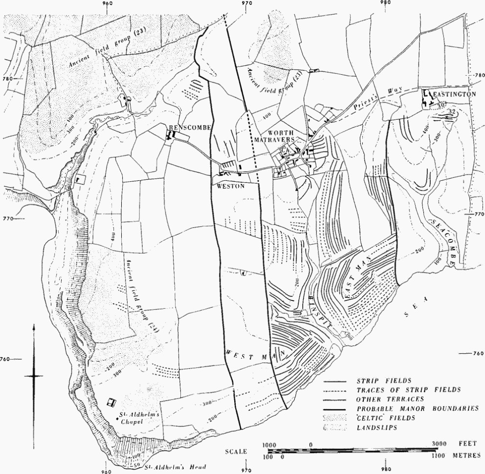
Worth Matravers, a parish covering 2,700 acres, lies in the S. part of the Isle of Purbeck, 3 miles W. of Swanage. It stretches N.N.E. from the steep cliffs of St. Aldhelm's Head across an almost flat limestone tableland formed by the underlying Portland and Purbeck Beds, between 350 ft. and 450 ft. above O.D., drained by three deeply cut valleys in which small streams flow S. to the sea. In the W. is Hill Bottom, and in the E. are Winspit and Seacombe Bottoms, both marked by impressive flights of strip lynchets of the former open fields of Worth Matravers. In the N. of the parish the limestone ends in a steep scarp below which is the wooded valley of the E. Corfe river on Wealden Beds around 150 ft. above O.D.
As elsewhere in Purbeck, the mediaeval settlement pattern is one of many small hamlets and farms, each with a more or less rectangular area of land, the boundaries of which are still marked by continuous lines of field walls and hedges. On the high limestone tableland are Renscombe Farm, Weston Farm, Worth Matravers and Eastington Farm. Domesday Book mentions holdings in Renscombe and numerous holdings in Worth, among which Weston and Eastington Farms are probably included. In the Corfe Valley are Woodyhyde, Downshay and Quarr, all probably much earlier than their earliest documentary references. The lands belonging to the farms in the valley stretched up on to the limestone plateau and included some of the principal medieval sources of Purbeck stone and marble.
The local stone is generally used for walls and roofs giving the village a picturesque quality though none of the houses individually is of architectural importance. The outlying farmhouses representing the early settlements are mostly of the 17th century. The Parish Church and St. Aldhelm's Chapel are the principal monuments.

Worth Matravers, the Parish Church of Saint Nicholas Of Myra
Ecclesiastical
a(1) The Parish Church of St. Nicholas (Plate 1) stands in the village. The walls are of local rubble with ashlar dressings; the roofs are covered with stone slates.
The church, comprising a Chancel, Nave and West Tower, was built c. 1100. In the 13th century the chancel was rebuilt, except for parts of the N. wall, and additional lancets were inserted into the nave; at a subsequent date, the elaborate chancel arch and S. doorway of c. 1160 were brought from elsewhere, probably after the Dissolution, together with contemporary fragments and incorporated into the building. The E. wall was rebuilt in the mid 14th century; a S. chapel added probably at this date was demolished in the late 18th century. The church was restored between 1869 and 1872. The gallery and roofs are modern.
The church is of interest in retaining much work of the 12th century, including a carved corbel-table of character.
Architectural Description—The Chancel (20½ ft. by 15 ft.) has reset corbel-tables of c. 1100 on the N. and S. walls, on the N. of ten corbels carved with grotesques, beasts' heads, a squatting man, a bird, a bird's head and a rabbit, on the S. human and animal heads and a running animal. In the E. wall is a mid 14th-century window of three trefoiled lights with curvilinear tracery in a two-centred head. In the N. wall are two 13th-century lancet windows with segmental-pointed rear arches. The S. wall has a deeply battered base and two lancet windows similar to those on the N.; between them is a doorway with restored two-centred head and chamfered jambs. At the W. end of this wall, running diagonally behind a buttress, is a 14th-century squint from the former S. chapel. The stilted semicircular chancel arch (Plate 206), of the mid 12th century but reset, is of three orders on the W. and two on the E. The orders are enriched with chevron ornament; the inner order springs from paired half-round shafts with conjoined moulded bases and scalloped caps, the other orders from attached shafts with similar bases and caps. There is a grooved straight-chamfered impost moulding and, on the W. side only, a moulded label with nail-head ornament; flanking the jambs on the W. are remains of the enriched inner jambs of recesses for side altars which flanked the chancel arch in its original position. In the gable above the arch is a double opening with two round arches, a central rectangular pier, plain responds and chamfered imposts, probably modern.
The Nave (46 ft. by 17 ft.) has on the N. wall at each end a pilaster buttress and between them a corbel-table with the corbels carved with human and animal heads and two with plain rolls with saltires at each end. High in the wall are two small windows of c. 1100 each with a rounded head, the head and jambs roll-moulded externally, and with a round rear arch. E. of the easternmost and at a lower level is a restored early 13th-century lancet above which was a square Elizabethan window to light the pulpit (Hutchins I, 699); this last has been destroyed and the opening blocked with carefully bonded masonry. The original N. doorway, between the earlier windows, has roll-moulded jambs with chevron stops and a round rear arch; the flat head is modern and above it there is blocking replacing a three-sided door-head shaped like that in Fordington Church (Dorchester 4); flanking the doorway are two narrow buttresses of ashlar which rise over the door in a parabolic arch to meet as a single pilaster buttress above. The S. wall is generally similar to the N. with a corbel-table, end buttresses, a central buttress divided about the S. doorway (of the lower part only the two bases remain) and a pair of round-headed windows, all of c. 1100. At the E. end of the wall is the square S.W. end of the squint, now glazed externally, and slightly above it to the W. a restored early 13th-century lancet. Adjacent to these on the W. is a blocked doorway, probably of the 14th century, to the former S. chapel; it has a triangular head, hollow-chamfered imposts and chamfered responds. The S. doorway has a reset semi-circular arched head and jambs carved with chevron ornament and a tympanum with a mutilated carving in two pieces depicting the Coronation of the Virgin.
The West Tower (10 ft. square) is of three stages with narrow chamfered offsets, rebuilt clasping buttresses to the lower stage to N.W. and S.W., and a modern pyramidal roof above a moulded corbel-table. The rebuilt tower arch is two-centred with chamfered imposts. Internally, on the N. is a plain doorway to the former stair; in the centre of the S. and W. walls are modern square-headed windows each of a single light, and to the W. a similar window above to light the second floor. The third stage has single square-headed windows in E., S. and W. walls and a two-light window with square mullion to the N.
The South Porch (9 ft. square) was built in the 18th century; the outer doorway has a modern flat head, and the jambs are chamfered externally and made up of reused 12th-century material with chevron ornament on the inside.
Fittings—Bell: three; 2nd 1719, 3rd 1736, both by William Knight but recast 1951. Bracket: in chancel, above S. door, grotesque head, c. 1100. Coffins and Coffin-lids: in chancel— in N.E. corner, (1) lid 2¾ ft. long, incised cross with head formed of circles and stepped base; in S.E. corner, (2) lid 5¾ ft. long, incised cross with seven trefoiled arms and stepped base, flanked by small Latin crosses. In porch, (3) fragment of lid, Purbeck marble, with hollow-chamfered edge and raised cross, discovered in 1957 approx. 400 yds. N.N.E. of St. Aldhelm's chapel over a burial (fn. 1) ; (4) lid 2¼ ft. long, hollow-chamfered edge and raised cross with circular ends and stepped base; (5) lid 3 ft. long, hollow-chamfered edge and raised cross on stepped base. All late 13th or early 14th-century. In churchyard, (6) coffin and lid 6¾ ft. long, hollow-chamfered edge and raised cross with trefoiled arms and stepped base, 15th-century. Font: octagonal bowl, sides with quatre-foiled diaper, moulded rim and lower edge; octagonal stem with moulded capping, trefoiled panelled sides and plain base, early 19th-century. Graffito: on jamb of S. porch, IT 1741.
Monuments and Floor-slabs. Monuments: in nave, on N. wall, (1) to Gerard William Vanneck, grandson of Lord Huntingfield, 1840, white marble tablet with achievement-of-arms on grey marble backing signed Reeves & Son Ft. Bath. In churchyard, N. of nave, (2) to Benjamin Jesty, 1816, '. . . the first person [known] that introduced the Cow Pox by Innoculation . . .', headstone; (3) to Elizabeth Jesty, wife of the above, 1824, headstone. Floor-slab: in chancel, (1) to Christopher Goss, 1698. Niche: in chancel, in E. wall, ogee cinque-foiled head, chamfered jambs and sill, 14th-century. Piscinae: in chancel—in E. wall, (1) ogee trefoiled head, chamfered jambs, plain round bowl, 14th-century; loose in S.E. corner, (2) bowl with quatre-foiled sinking, 14th-century. Plate: includes a cup, undated, and cover-paten of 1574, with identical maker's marks. Scratch Dial: on S. porch, on S. wall. Miscellanea: in S. porch, on E. wall, reset fragment of canopy head and rectangular side standards, under side of head with ribbed vaulting and traces of red paint, late 14th-century; perhaps the fragments referred to in Hutchins (I, 700) as found in a farmhouse and placed in the squint by Rev. A. Kemp (vicar 1843–50).
a(2) St. Aldhelm's Chapel (Plate 205), on St. Aldhelm's Head, (13/8 m. S.S.W.) is of coursed rubble with ashlar dressings and has a pyramidal roof covered with stone slates. The chapel was built in the late 12th century, possibly to incorporate a seamark, and was served, at least in the 13th century, by a royal chaplain (Hutchins I, 698). It was restored in the early 19th century and again, by Lord Eldon, in 1873.
The building is of one compartment (25½ ft. square) with its angles pointing approximately to the cardinal points. The outer wall has an original battered base along the S.W. side and the N. half of the S.E. side. At the S. angle is an original clasping buttress with a splayed base, rising to half the height of the wall; at the E. corner is a pair of 13th-century angle buttresses of similar height; four tapering buttresses with raking courses were added in post-mediaeval times. Between the heads of the older buttresses, on the S.E. side, is a late mediaeval moulded string-course; the N.E. wall has an original moulded corbel-table. The doorway in the N.W. side has a round head and jambs of two chamfered and grooved orders, the chamfer stopped above and below the imposts, and a moulded label with nail-head enrichment; in the opposite wall is a lancet window with widely splayed internal reveals and round rear arch. At the apex of the roof is a short cylindrical ashlar pier, now supporting a cross erected in 1873 but perhaps originally carried up more prominently as a seamark for shipping; the suggestion that it provided the base for a fire-beacon seems untenable.

St. Aldhelm's Chapel, Worth Matravers, Dorset
The interior (Plate 206) has a large clustered central pier, half-pier responds in the middle of each wall and angle shafts, all with chamfered imposts; these support four quadripartite vaults with heavy cross and diagonal ribs covering the chapel. The cross ribs and their vaulting shafts and the diagonal ribs have the same rectangular section, but the vaulting shafts of the diagonal ribs comprise single salient angles. All the foregoing members have stopped chamfers. The floor has been raised and the altar steps have been rebuilt in recent times.
Fittings—Inscriptions and Scratchings: many dates and initials on central pier and responds including TD 1629, IC and MC 1665, HC 1709. Recess: in S.W. wall, at S.E. end, plain with square head and jambs and sloping sill.
Earthworks—The chapel stands on a 2 ft. high platform in the middle of an irregular earthwork enclosure defined by a bank at most 3 ft. high externally and 1½ ft. high internally; it probably contains stones. No certain entrance is visible, but a slight, possibly original, gap occurs on the N.E. In addition to the chapel, which is at the centre of the enclosure, the interior contains on the S.W. a later ditch 2 ft. deep, which cuts the back of the bank at the W. corner and turns through two near right-angles towards the chapel door. Between the ditch and the bank on the S.W. is a slight rectangular platform, possibly the site of a building, and a shallow rectangular depression on the S. which may be of similar origin.
Monuments (3–27)
The following monuments unless otherwise described are of two storeys, or in a few instances of one storey with attics, and have walls of local Purbeck stone rubble and stone-slated roofs; they are of the late 18th or early 19th century.
a(3) Gazebo (60 yds. S.) is probably modern but has, reset, a late mediaeval window of two trefoiled lights with sunk spandrels and another window of two uncusped pointed lights of uncertain date.
a(4) House, Stoneleigh (40 yds. S.), has been enlarged towards the N. and remodelled internally.
a(5) Lobster Cottage (40 yds. S.W.) is a modern reconstruction of two dwellings perhaps of the 17th century. A two-light stone-mullioned window is reset in the porch.
a(6) Post Office (60 yds. E.), house with modern shop added.
a(7) Bridle's Cottage and Gulliver's Cottage (80 yds. E.) are of the 17th century but much altered; they retain some original stone-mullioned windows.
a(8) Square and Compass p.h. (230 yds. N.E.) was enlarged in the 19th century.
a(9) Worth Farm, house (160 yds. E.), has a datestone of 1847 probably giving the date when part of the building was converted to a school.
a(10) Cottages, three, and Blacksmith's Shop (140 yds.E.) form one group.
a(11) Cottages, two (200 yds. S.E.).
a(12) London Row, five dwellings (80 yds. S.E.).
a(13) Cottages, a pair (50 yds. S.E.).
a(14) Cottage at Weston Farm (969773) adjoins the later farmhouse.
a(15) Weston Farm Cottage (968773).
a(16) Weston Cottage (967772).
a(17) Renscombe Farm (964776) is of the 17th century. On plan the house consists of a long straight range, now divided into five rooms, with a wing of shallow projection to the W. and close to it a second small wing containing a staircase. The original doorways have four-centred heads and the windows have hollow-chamfered stone frames and mullions. Reset in the staircase wing is part of a stone window frame with one plain pointed light of uncertain date. Barn, E. of house, with two porches to the W. may also be of the 17th century.
a(18) Elm Cottage, at Hill Bottom (961778), was built as a pair of double-fronted dwellings.
a(19) Eastington Farm (983777) was built in the late 17th century on a T-shaped plan giving three heated rooms on the ground floor; it was enlarged in the 18th and 19th centuries. The house has been much altered but retains several original round-headed single-light windows, some reset in an added wing.
a(20) Gallows Gore Cottages (982788), range of three dwellings.
a(21) Dunshay Manor (980796) is of the 17th century, partly rebuilt in 1906. The house is presumed to stand on the site of the mediaeval manor house which Leland states belonged to Alice Breuer who gave marble from her quarries for the building of Salisbury Cathedral.
The house is roughly square on plan with two gables flanking a central porch on the E. front; on each side of the porch are rainwater heads one with the initials and date I A D 1642 for John Dolling and the building of the house, one with M G M 1906 for the rebuilding of the N.E. part. At the N.W. corner the plan is irregular and includes a modern single-storey addition above which, in the 17th-century wall, is a pedimented niche containing a mutilated carved stone figure. Most of the windows have stone frames and mullions, some with labels; those at the S. end of the W. elevation have stops to the labels carved with initials E D and C D for other members of the Dolling family; the inner entrance doorway under the porch has a moulded four-centred head and continuous jambs. The interior has been rearranged but retains some 17th-century panelling and, on the first floor, an original fireplace with chamfered elliptical head.
Downshay Farm, S. of the manor house, has a modern farmhouse into which two 17th-century stone-mullioned windows have been reset. Farm buildings are probably of the 18th century.
a(22) Haycraft, house (984796), was built in the late 17th century on a two-room plan with one end chimney and has been considerably enlarged and altered.
a(23) Primrose Hill Cottage (986795) is built on a two-room plan with one end chimney.
a(24) Quarr Farm, house (989797), has at the E. end a small part of a 17th-century house with hollow-chamfered stone window-frames and mullions and also a window with ovolo-moulded timber frame and mullions. Projecting from the E. end are short fragments of walling finishing in doorjambs indicating a through passage. The main part of the present house is a small 18th-century building symmetrically designed with a central entrance and casement windows. A small Outbuilding S.E. of the house includes some 17th-century stonework; its E. wall may be a part of the original house. Barn, to W., roofed with modern sheeting, is probably of the 18th century but has been much altered.
b(25) Caplestone Cottage (979803) is built on a central chimney plan; the chimney is of brick.
a(26) Winspit Cottages (976762), a pair.
a(27) Coastguard Station (960756) was built as a range of four cottages in 1834.
Earthworks, Etc.
Mediaeval and Later Earthworks
Settlements and Strip Fields. Several recorded ancient names can probably be related to former land divisions. Renscombe, Worth Matravers, Eastington and Weston are all listed in Domesday Book, the last three as separate 'Worths'. Boundaries of land attributable to these places are strongly suggested by surviving runs of field boundaries occasionally supplemented by traces of banks and scarps making up the original continuous lines. The areas of the parcels of land so defined are approximately as follows: Renscombe, 730 acres; Weston, 210 acres; Worth, 710 acres; and Eastington, 330 acres. Remains of mediaeval settlement survive at Weston (28) and at Eastington (30) where 'pillow-mounds' (32a–c) are probably associated with them. The Priest's Way, an ancient road between Worth and Swanage, passes N. of Eastington. Other remains (33) near Downshay Farm are probably the site of another small early settlement.
Contour strip lynchets in Worth are extensive and mostly well-developed. Similar remains in Eastington are very broken, but in spite of widespread quarrying, much of it recent, there are no signs that they were ever extensive. The very slight contour strips above the sea to the S. of Weston contrast notably with those immediately E. in Worth on West Man. The confused and ill-developed remains S. of Renscombe are described with Ancient Field Group (24). (R.A.F. V.A.P. CPE/UK 1821: 1393–9 and 3400–4.)
a(28) Settlement Remains at Weston (969774), over at least 3 acres, lie immediately W. of Weston Farm, on apparently well-drained ground (Lower Purbeck Beds) rising gently N. They include a scarped platform about 1½ ft. high in a field bounded W. and S. by the present road; beyond it are five contiguous plots, each 60 ft. to 90 ft. wide and up to 120 ft. long from N. to S., divided from each other by very spread banks up to 15 ft. wide and 2 ft. high. There are in addition very faint indications of something similar in form and area E. of the farm and broken remains of uncertain form lie S. of the road. (R.A.F. V.A.P. CPE/UK 1821: 3403.)
Worth Matravers. Mediaeval Settlements and Fields.
a(29) Strip Fields (973757-980774; Plate 198). Almost the whole area within the suggested boundaries of the manor of Worth to the S. of the village bears traces of strip fields of the open field system. Remains clearly visible on the ground cover some 100 acres but others can be identified over a further 190 acres. They line the valley running S. to Winspit, most of its side gullies, the prominent spurs of West Man and East Man above the sea and the E. side of the ridge W. of Seacombe Bottom. The subsoil is Lower and Middle Purbeck limestones and marls except towards the sea where there are marls and shales; land-slips on West and East Man are probably due to these.
Most of the surviving strips are contour strip lynchets. Despite some recent quarrying and ploughing, their pattern is generally well-preserved and some groups present excellent examples of this form of field (Plate 198). The dimensions vary: strips are from 70 yds. to 280 yds. long but generally over 200 yds.—a length of 450 yds. on East Man was probably sub-divided—with treads 3 yds. to 30 yds. wide; riser heights vary between 9 ins. and 15 ft. and the transverse slope on treads from 4° to 15°. Strip lynchets run up-and-down the S. side of a gully about 977767; the slope along the treads is 15°. Other strip lynchets run obliquely across the contours W. of Seacombe Bottom around 980772. E. of the village near 976774 are six strips 20 yds. to 25 yds. wide divided by very spread scarps up to 1½ ft. high; these may have been village closes. The ploughed-over remains on flatter ground, most of which is now arable, are too much disturbed to indicate their original form. Narrow rig occurs on parts of East and West Man, both of which were arable on the Tithe Map of 1840, and above Seacombe Bottom. It is associated with destruction of the less well-developed strip lynchets. On the S. slope of both E. and W. Man furlongs laid end-to-end meet on the areas of slumped soil from the old landslips. (R.A.F. V.A.P. CPE/UK 1821: 1393–7 and 3401–3.)
a(30) Settlement Remains (98377777), immediately S.E. of Eastington Farm (19), lie at the head of a deep combe on ground sloping down gently E. from about 430 ft. above O.D. Very disturbed contiguous rectangular platforms, with scarps up to 3 ft. high, include at least five which are likely to have been house sites. These lie within about ½ acre but further traces of large scarped closes to the E. cover some 3 acres.
From a point 60 yds. to the S.E. of the platforms three broad sloping terraces drop to the combe floor with scarps some 9 ft. to 16 ft. high; they are now under pasture but have probably been developed by cultivation and other usage on natural shelves. On the middle terrace lie three 'pillow mounds' (see below, 32a-c) and a roughly rectangular platform measuring about 18 ft. by 7 ft. Immediately below in rather marshy ground are traces of two adjoining rectangular enclosures measuring about 54 ft. by 48 ft. and 30 ft. by 18 ft.
The combe floor and its E. slopes to the S. of these remains are very uneven. The lowest portion of the combe has apparently been ploughed for a short time in recent years. A D-shaped pound enclosed by dry-stone walling lies 150 yds. S.E. of the settlement immediately above a spring at 98527770. (R.A.F. V.A.P. CPE/UK 1821: 3400–1.)
a(31) Strip Lynchets (982776, 983772), much damaged, covered in narrow rig and crossed by a dry-stone wall, lie on the W.-facing slope above Seacombe Bottom S. and S.W. of Eastington Farm. Above them on the spur top are further very faint traces of strip fields and remains of others lie 700 yds. S. of the farm. (R.A.F. V.A.P. CPE/UK 1821: 3400–1.)
a(32) Pillow Mounds, three (98427770; Plate 207), lie on a terrace near the settlement remains at Eastington (30). The largest (a) is a long mound lying E. to W. on a slope of 6° immediately above a scarp about 16 ft. high. It is 60 ft. long and 21 ft. to 25 ft. wide surrounded on three sides by a ditch which, at most, on the E., is 3½ ft. below the top of the mound but merges with the scarp on the S. Although slightly asymmetrical, the earthwork gives an impression of sharpness and regularity; its ends are almost rectangular. There is no evidence that the terrace immediately N. of it has been ploughed since the mound was constructed.

Pillow Mound
The two other 'mounds' are sloping shelves constructed under the scarp of the upper terrace. (b), 20 yds. N. of (a), is about 50 ft. long and 6 ft. wide across its sloping top with a S. scarp about 5 ft. high returning to merge with the slope at either end. (c), 30 yds. to the W. in a comparable position but cut back into the face of the scarp, measures 27 ft. by 15 ft. with a downhill scarp about 5 ft. high and a top sloping E. and S. (R.A.F. V.A.P. CPE/UK 1821: 3400–1.)
a(33) Earthworks, remains of mediaeval settlement (around 97757973), lie some 370 yds. W. of Downshay Farm (21) which 'seems at one time to have been regarded as the site of the manor' (Hutchins I, 694). The remains extend N. from beneath a steep quarried slope on pasture falling gently N. to ground drained by a stream which flows W. towards Afflington; another stream borders them on the E. At the S. four contiguous flat rectangular platforms lie one below the other in a S. to N. line. They all measure about 70 ft. from E. to W. and from S. to N. measure 48 ft., 24 ft., 27 ft., and 24 ft. The last three are defined by scarps varying from 9 ins. to 3½ ft. high.
Parallel banks 70 ft. apart continue N. from the E. and W. sides of the N. platform, but with no sign of subdivision or levelling between them. The W. bank, about 12 ft. wide and only a few inches high, disappears after about 60 yds. The E. bank increases in size as it approaches the stream, where it ends, to about 16 ft. wide and 3½ ft. high with a flat top 4 ft. across. (R.A.F. V.A.P. CPE/UK 1821: 5405.)
Other Earthworks and Allied Monuments
(34–36) Round Barrows, p. 474
(37–38) Mounds, p. 483
(39–43) Roman Burials and Industrial Sites, p. 620
Ancient Field Groups (23, 24), p. 630