An Inventory of the Historical Monuments in Dorset, Volume 2, South east. Originally published by Her Majesty's Stationery Office, London, 1970.
This free content was digitised by double rekeying. All rights reserved.
'Hill-Forts', in An Inventory of the Historical Monuments in Dorset, Volume 2, South east, (London, 1970) pp. 483-501. British History Online https://www.british-history.ac.uk/rchme/dorset/vol2/pp483-501 [accessed 23 April 2024]
HILL-FORTS
Eight earthworks in the area covered by this Volume are classified as hill-forts. These, with one possible exception, Woolsbarrow, Bloxworth (44), all belong to the Iron Age. Bindon, W. Lulworth (53), is not a true hill-fort but has some comparable features and can be regarded as a gigantic promontory enclosure of the same period. Only Maiden Castle, Winterborne St. Martin (142), has been intensively investigated and even there only a very small proportion of the interior was excavated. Three others have been sampled by excavation and only Woodbury, Bere Regis (118), and Woolsbarrow have never produced significant finds. All these earthworks began as simple enclosures with one main bank and ditch. Such univallate construction with a berm between bank and ditch is mostly attributable to the Iron Age 'A' culture, an attribution confirmed at Bindon, Chalbury (Bincombe (76)), Maiden Castle and Poundbury (Dorchester (172)). Multiplication of the defences by the succeeding 'B' and 'C' cultures was normal. The univallate fort of Bulbury (Lytchett Minster (30)), however, produced a find of La Tène objects probably deposited during the 1st century A.D.; the original construction of the work is undated, but it is the only hill-fort in S.E. Dorset that does not occupy an obviously commanding position.
In size and scale the defences vary from an insignificant ditch surrounding a gravel plateau of only two acres at Woolsbarrow to the multiple ditches, some still 50 ft. deep, and complex entrances at Maiden Castle, 47 acres in internal area and the most massively defended prehistoric earthwork in Britain. The excavator of Maiden Castle thought that the multiplication of ramparts and ditches there and elsewhere was due to the needs of defence in sling warfare. This view perhaps needs to be modified not only because the increased depth improves defence against any sort of attack but because in Gaul large hill-forts of the same period were generally univallate. There is, however, little evidence for archery in the Iron Age and the Chesil Beach was certainly a ready encouragement to the lavish use of sling-stones. The area within the Bindon rampart, about 400 acres, nearly twice that of Ham Hill, Somerset, the largest hill-fort in the British Isles, seems to have been a collecting area for immigrants from the Continent at some early phase of the Iron Age. As such it is perhaps best compared with Hengistbury Head, Hants.
Details of construction and development are best seen at Maiden Castle. The box rampart characteristic of Iron Age 'A' was, however, found in variant form at Chalbury, revetted with stone which was available inside or immediately outside the hill-fort. At Maiden Castle such stone revetment walls occur in a later phase but the stone had to come from at least 2 miles distant. Excavation of the exceptionally complex E. entrance to Maiden Castle demonstrated clearly how archaeological techniques can reveal the evolution of a site and finally link it with a firm historical fact, the Roman invasion of A.D. 43. The entrance to Bindon is the only other example to have been excavated. Its inturned arms are notably long, about 60 ft., though inturns 82 ft. long were alleged by Edward Cunnington to have existed at Bulbury. Outlying defences occur 180 yds. E. of Flower's Barrow (E. Lulworth (40)) where a dyke spans the ridge leading to it. There are probable examples of such cross-ridge dykes covering the approaches to hill-forts elsewhere in Wessex (as at White Sheet Hill, Kilmington, Wilts.) and a number of such dykes facing outwards from an Iron Age 'A' settlement on Knowle Hill (Church Knowle (54, 56)) might easily have been developed into a small hill-fort.

Woodbury Bere Regis, Chalbury Bincombe
Definite signs of occupation such as hut-platforms and pit sinkings are visible now only in Chalbury and Flower's Barrow. Most have been extensively disturbed by later activities. Ploughing has obliterated surface traces in Maiden Castle but excavation and analogy suggest that its interior would have been full of such remains. That the nature of the occupation was one of permanent settlement was shown by its continuation until c. A.D. 70. At Poundbury, also heavily ploughed, some test excavation produced no sign of interior structures. All the certain houses that have been found were round or polygonal and only exceptionally as much as 30 ft. in diameter. Some stone footings were found in Maiden Castle as well as Chalbury. One such structure (Chalbury, 'D') was built in a quarry pit (cf. Church Knowle (54)). Storage pits at Maiden Castle were occasionally stone-lined. Many were beehive shaped and about 6 ft. deep, suggesting a relationship with those found in the Isle of Portland and known as 'Portland beehives' (see Roman section, p. 606; Geologists' Association, Procs. VIII (1883–4), 404–10). Internal roads were found only in Maiden Castle. One of them led towards the largest of the hut-circles within which had been built, in the late 4th century A.D., a hut associated with a Romano-British temple. One of the three roads in the comparable hill-fort of Hod Hill (Dorset III, forthcoming) led to a structure which Sir Ian Richmond's excavation has shown to have been of pre-eminent importance at the time of the Conquest. No early ponds or wells have been proved and it seems that water, if not fetched from the nearest outside source, was generally collected from eaves drips and the like, though Sir Mortimer Wheeler found water channels leading into pits at Maiden Castle. The only cemetery certainly associated with these hill-forts is at the E. entrance to Maiden Castle.
'Celtic' fields now touch only Bindon and are not necessarily contemporary. Others lie very close to Flower's Barrow (Ancient Field Group (17)). Mediaeval ploughing destroyed any that may have existed near Chalbury or Maiden Castle and those 1 mile N. of the latter (R. E. M. Wheeler, Maiden Castle (1943), Plate LXX) are now known to lie around extensive Romano-British 'open' settlements (Fig. p. 494), though they could well have had Iron Age origins.
It seems certain that some of these forts were centres of political authority and expressed the power of their builders, but there are no clues to the limits of territories ruled from them (cf. Fig. opp. p. 634). The Roman invasion put an end to the power of the rulers of those hill-forts still in use, but not all were immediately or finally abandoned. Within Maiden Castle a Romano-British temple was built in the late 4th century, and in Chalbury and Poundbury scatters of pottery indicate at least casual Romano-British use.
In different ways the forts probably also sheltered men and animals during later periods. A pagan Saxon burial came from the Long Mound in Maiden Castle. Woodbury was the site of a sheep fair. At the time of the Armada Sir John Norris seems to have considered the hill-forts near Dorchester as 'divers old intrenched places which might be made stronger at a small charge but to little purpose' (B.M., Harl. MS. 3324, art. 6, quoted by Hutchins II, 828). Ploughing of the interiors probably began early and was noted at Maiden Castle in about 1610. In two cases damage has been more drastic. Three-quarters of the interior of Woolsbarrow has been quarried away by gravel diggers and at least one third of Flower's Barrow has collapsed seawards, owing to coastal erosion.
Bere Regis
(118) Woodbury (SY 89 SE; 856948) is a contour hill-fort which occupies the entire flat top of the gravelcapped spur called Woodbury Hill 360 ft. above O.D., ½ mile E. of the parish church. The area enclosed is about 12 acres.
The defences, though now much broken down, consist of a main inner rampart, at best 40 ft. wide and 19 ft. high above a single ditch, 5 ft. deep and 30 ft. wide, and a relatively massive counterscarp bank up to 26 ft. across, beyond which the ground falls steeply on the E. side and greater part of the S. side. On the N.W. there is a sloping shelf between the ramparts and the steep face of the hill. On this shelf is a series of rather flat-topped parallel ridges 1 ft. high, 10 yds. or so wide and about 50 yds. long, divided by furrows about 4 ft. wide. These are more likely to be connected with the annual sheep fairs once held in the hill-fort (Hutchins I, 135) than with agriculture. To the N. a gently dipping but fairly narrow saddle connects the spur with the main ridge. At this vulnerable point the outer bank seems to have been thrust about 70 yds. forward from the main rampart but the remains have been heavily ploughed. In the lane to the N.E. is a double fall which might mark the line of a ditch but this cannot be confirmed.
The present road in from the S.W. probably follows the line of an original entrance, as possibly does that at the N.E.; but all the other breaks in the defences seem to be secondary. The surface of the interior is uneven in many places but it is impossible to detect anything certainly ancient. The chapel shown on the plan certainly existed in the early 15th century and its footings were still traceable in the late 18th century (Hutchins, ibid.). The nearby well was traditionally associated with it.
Bincombe
(76) Chalbury (SY 68 SE; 695838; Plate 216) is a contour hill-fort with single rampart and external ditch, the former augmented by an interior quarry ditch, or line of quarry pits, running inside it for 3/5 of its length. There is one original entrance at the S.E. The interior, of about 8½ acres, shows extensive signs of occupation. The rampart encloses the domed crest of a knoll, partly Lower Purbeck Limestone and partly Portland Sands, standing prominently at 380 ft. above sea level in a controlling position at the N. end of a ridge (Rimbury) which splits a valley leading inland from Weymouth Bay (Figs. pp. 24, 484). Excavation by Miss M. Whitley in 1939 has shown that it belongs to Iron Age 'A' (Ant. J. XXIII (1943), 98–121).
Strip lynchets (Bincombe (11)) run into the defences on the N., and on the N.E. lie at their foot along the steep scarp beneath them; on the E. side are a narrow cultivation terrace and a terraced approach, both of uncertain date. The external ditch running N. from outside the entrance seems to have been converted into a cultivation terrace for much of its length. A large modern quarry bites almost up to the ditch on the W. and it is possible that shallow quarrying of a date later than that of the original occupation might be partly responsible for some of the more irregular sinkings inside the hill-fort. The whole is now pasture. The nearest source of water at present is a spring ½ a mile to the S.
The rampart stands 1 ft. to 3 ft. above the interior except near the centre of the E. side, where it is little more than a scarped edge; its height above the external ditch averages about 21 ft. Where excavated it was seen to have external and internal limestone walls retaining the soil and stone core. Internally there was also, at the S.E., a stone kerb at the tail of the rampart. Externally, convenient stone outcrops were utilised in the structure of the wall and there was a berm 5 ft. to 9 ft. wide. The flat-bottomed ditch was cut into the bed-rock at a variable distance below this. For the greater part the ditch has a terraced appearance. On the E. for 40 yds. N. from the entrance it is rather irregular, some 2 ft. deep.
The internal quarry ditch runs N. from the entrance as a parallel-sided ditch for 115 yds. It was originally about 18 ft. wide and 5 ft. deep but was allowed to silt up quickly and used as a sheltered occupation area. A 'causeway' blocks this run of ditch and thereafter it is supplanted by a series of quarry pits, broken at the extreme N. by another 'causeway', here found to consist largely of sand. About 100 yds. S.W. of this, the well-marked line of pits gives place to a series of much shallower scalloped depressions which ends abruptly after a further 65 yds. There is, however, no apparent correlation between the size and different treatment of the quarry ditch or pits and the dimensions of the rampart immediately adjacent. A flattened strip, 55 ft. and more wide, lies inside the S. rampart, the slight scarp defining it on the N. side being a continuation of that N. of the entrance.
The entrance is a simple gap with slight hollowing, perhaps partly cut rather than worn, immediately inside. A ramped approach might be original. A track climbing diagonally across the rampart 120 yds. S.W. of the entrance is not original.
Two small banks run downhill from outside the ditch. One, from the natural shoulder at the S.W., is 15 ft. wide and 1 ft. high and ends after 33 yds., before reaching the quarry edge. The second, 75 yds. to the N., has a slight ditch on the S. side and is cut by the quarry after 25 yds.
The interior is pocked by numerous roughly circular depressions and weakly-defined platforms. The latter, of which there are 30 or more, appear largely to be ranged around the perimeter, though the hut 'D', built in a shallow Iron Age quarry, was notably high up the slope. Only one platform, 20 yds. S. of the northern 'causeway' across the quarry ditch, had a bank.
The most irregular depressions might be quarries of any date, but if of the Iron Age are likely—as at 'D'—to have been put to some use. The smaller circular depressions up to about 15 ft. across, of which there are at least 20, probably represent original storage pits. There are two main groups, one N. of hut 'D' and one just W. of round barrow Bincombe (74). The only excavated example (in the northern group) was round, 5 ft. in diameter and 4 ft. deep, with straight sides cut into the rock. Both of the Bronze Age barrows (73) and (74), set so prominently on the summit of the hill, were apparently respected.
The excavation of the hill-fort was limited to the following features:—the rampart, ditch and quarry ditch 25 yds. N. of the entrance (site 'A'), the rampart, quarry ditch and causeway across it at the northern tip of the hill-fort (site 'C'), occupation layers with post-holes, probably a hut, in the quarry ditch at site 'A', building 'D', two scooped-out platforms with no signs of structure and few finds, and one storage pit. The building 'D', partly stone-walled, was the only site completely excavated in the interior: it was odd in that, despite abundant evidence of occupation across an internal diameter of 33 ft., it seemed to have neither hearth, entrance nor post-holes.
Apart from a Late Bronze Age layer buried under the rampart at the extreme N., a thin scatter of Romano-British potsherds at site 'D' and a fragment of samian ware in the ditch, the finds were all of Iron Age 'A', exhibiting two phases, the earlier having the finer specimens of haematite pottery. Hut 'A' belonged to the earlier phase and 'D' to the later.
Other finds included a small tanged iron knife, bone 'gouges' (cf. p. 499), a very small annular blue-glass bead, fragments of a bronze ring, a bronze bracelet or ear-ring, bronze binding and rivets, a piece of a saddle-quern, charred wheat (identified as Triticum vulgare by Prof. Percival), a spindle-whorl and slingstones. There were also 11 worked flints, including an endscraper and borer, of somewhat uncertain date but apparently stratified with the Iron Age material. Scatters of human bones were found, but only a few animal bones—including ox and sheep.
Bloxworth
(44) Woolsbarrow (SY 89 SE; 893925; Plate 212), on Bloxworth Heath and now in a State Forest midway between the Sherford River and a tributary of the Piddle, both ½ mile distant, is the smallest hill-fort in South-east Dorset. Its anomalous form makes its date uncertain.
A single bank with inner ditch surrounds a gravel knoll some 20 ft. below its flat top, enclosing an area of some 2¼ acres. Though the highest point is only 220 ft. above O.D. it dominates the surrounding heathland, which falls sharply on all sides except on the S.E., where a simple gap entrance leads to a natural saddle connecting the hilltop with a lower spur.

Woolsbarrow, Bloxworth
The whole site has been much disturbed. Most of the interior has been quarried away to a depth of some feet, exposing a well-formed podsol, but there is no evidence that a bank ever stood on the edge of the inner scarp. The mounds in the S.W. and N.E. angles are probably no more than the residue of quarrying; the N.E. mound was dug by a Mr. Groves of Wareham without result (Warne, Ancient Dorset, (1872), 87). Soil slip has largely filled the ditch and the bank, at its most prominent, is about 18 ft. across and only 2½ ft. above the ditch bottom. A modern trackway obscures the original form of the entrance. The 'tumuli' shown on some maps around the site are probably natural, the result of differential erosion (Hutchins I, 181).
Dorchester
(172) Poundbury (SY 69 SE; 682911; Plate 212), a hill-fort of 13½ acres, lies approximately 2/3 mile W.N.W. of St. Peter's Church, Dorchester, on a bluff of the Upper Chalk at about 300 ft. above O.D. (see Fig. p. 494). Its size and trapezoidal shape are not, apparently, much dependent on its situation. The defences now consist of two banks and two ditches of similar size but variably damaged. Where best preserved, the inner bank is 66 ft. wide and 18 ft. above its ditch. There are only very faint traces of an inner quarry ditch. The interior slopes gently N. and E. but the ground outside falls precipitously to the River Frome on the N., gently away on the S. and E. (where a shallow combe divides the fort from Dorchester), and rises slightly from it on the W. Excavation has shown two main structural phases attributed to Iron Age 'A' and Iron Age 'C' (Ant. J. xx (1940), 429–448).
In the Roman period the aqueduct for Durnovaria (see Roman section, p. 585) was taken along the outer ditch on the N. and apparently involved the destruction of the outer rampart for part of the E. side. Other activity in the Romano-British period (fn. 1) is testified by the considerable spread of 3rd and 4th-century pottery and some of the gaps through the defences on the S., S.W., and N.W. may belong to this period. The earthwork is now used for pasture but has been extensively damaged. In 1855 construction of the railway tunnel defaced the defences on the N. and E.; during the war of 1939–45 a rough wide trench with spoil heaps on its outer side was made along the outer base of the main rampart for most of the W. and S. sides and at the S.E. angle; portions of the summit of the main rampart on W. and S. have been flattened, and the S.E. angle has been cut into from the inside. The interior has been ploughed and this probably involved some prior destruction of the round barrow in the S.W. quarter of the interior (Dorchester (170)). An Early Bronze Age sherd and one of Rinyo-Clacton ware (in D.C.M.) were found in 1947 in slight ditches sealed by a turf line under the main bank near the S.W. corner (Dorset Procs. LXXXVI (1964), 106–7).
In 1939 Miss K. M. Richardson dug a single trench through both ramparts and ditches where best preserved, on the W. (just S. of JK on the plan), and further tested details by smaller cuts. These showed two phases of construction. The main rampart had at first been faced by a vertical timber palisade (where shown on her plan not parallel with the existing ditch), set back some 4½ ft. from the lip of a funnel-shaped ditch 29 ft. wide and 14 ft. deep, its bottom a slot little more than 1 ft. wide and 2 ft. deep. There was no indication of any rear revetment to the rampart and the layers all tilted up towards the front. Some of the material seems to have been obtained from an internal quarry ditch.
This primary bank had become grass-covered before being enlarged and converted to glacis form. A second bank (also of glacis form) with external V-shaped ditch was added on the outside. Fresh material, dug largely from a new and deeper internal quarry ditch, was piled in horizontal strata against the inside of the first bank. A mass of chalk blocks capping this was held at the forward edge by a revetment of limestone drywalling built on the surface of the old bank. An unbroken turf line over the silting of the ditch showed that it had not been recut. The new, outer, bank was of simple dump construction, its ditch of approximately the same size as the inner one but without the narrow slot at the bottom. In section the vertical height from the crest of the present inner rampart to the old turf line over the silt in the original ditch was approximately the same—22 ft.—as that from the crest of the outer rampart to the bottom of its open ditch. A cut section drawn by the railway surveyor S. of the present tunnel entrance during excavation of its approaches in 1855 showed the aqueduct and other substantial alterations to the outer defences but generally agrees with the above results. 'Ridgeway stone' (probably from the Iron Age 'C' revetment) was also found in the upper fill of the inner ditch (drawing in D.C.M.).

Poundbury, Dorchester
Although no pottery was found in the early filling of the first ditch it seems likely that the primary defences were univallate and of Iron Age 'A'. The remodelling of the defences probably belongs to Hawkes's Southern Third C culture— sometime after the middle of the 1st century B.C. The excavator's very tentative suggestion that the limestone revetment wall on the forward crest of the inner rampart might reflect a Belgic technique now seems unsupported by the lack of true Belgic pottery. The distribution of 'C' finds in the ditch-fills indicated a long period of usage during this phase, though some 38 trial holes, 3 ft. square, widely distributed over much of the interior, produced no evidence for permanent occupation.
Lulworth, East
(40) Flower's Barrow (SY 88 SE; 864805; Plate 215) is a hill-fort situated between 460 ft. and 567 ft. above O.D. on the cliff edge at the extreme W. end of the Purbeck Hills, known here (because of the hill-fort) as Rings Hill. The subsoil is Upper Chalk with outcropping sands and clays of the Corallian Beds. Probably a third or more of the original hill-fort has collapsed seaward as a result of coastal erosion, which had already taken place by 1744 (note by Edward Weld in D.C.R.O.). There remain three sides of an enclosure with two main banks and ditches and an original entrance to the S.E. The whole earthwork covers about 15½ acres. Occupation platforms are visible along the N.-facing slope of the interior. The ground falls away very steeply on the W., N. and S.E. but only very gently along the ridge to the E. where, 180 yds. away, a dyke (41) spans three-quarters of the ridge top.
The present earthwork is clearly the product of at least two main phases of construction. The inner enclosure, still 6 acres in area, has a rampart up to 30 ft. wide and in places 30 ft. high above its present ditch bottom and, inside it, a broad quarry ditch which is not, however, continued S. of the entrance. The end of the rampart N. of the original entrance gap is slightly inturned. A counterscarp bank lies immediately beyond the main ditch on the W. and N. but not on the E. At the N.W. angle of the inner enclosure the counterscarp bank is met by the main outer rampart but a later broad track has been cut through at this point. The outer rampart is separated from the counterscarp bank on the N. side by a berm of uneven width averaging 15 ft. to 20 ft., except at the N.E. corner where a bend in the outer rampart reduces it to 6 ft. The space between ramparts increases to 100 ft. on the E. and 180 ft. on the W. Within this area on the E. is a stretch 200 ft. long of low uneven bank following the alignment of the ramparts and situated mid-way between the inner ditch and the outer rampart. It has no visible ditch and its origin is unsure. On the steep slope to the N.W. the outer rampart is scarcely more than a scarp, rising some 33 ft. above its ditch bottom, but on the more level ground to the E. it is a true bank standing 8 ft. above the ground behind it and 20 ft. above the ditch bottom. On the S.E. this rampart curves towards the cliff edge and opposite the inner entrance is a gap, probably a mutilated original entrance, facing S.E.
The interior of Flower's Barrow rises gently to the E. and S., on which side nearly half of the remaining area has subsided to a maximum of 12 ft. behind the main cliff fall. A dozen or so roughly elliptical platforms are traceable in the N. half, concentrated towards the E. These have been levelled 2 ft. or 3 ft. into the slope and can probably be regarded as hut sites or working areas (cf. Chalbury, Bincombe (76)). There is now no surface indication of pits but one was excavated in 1939. It lay some 30 yds. inside the entrance and measured about 3 ft. in all directions; it produced bone refuse, a few sling-stones and about 60 sherds 'all probably of Iron Age B' (J. B. Calkin, Dorset Procs. LXX (1948), 44). In the early 19th century a skeleton, said to be of abnormal length, was discovered just beneath the surface of the inner rampart (J. F. Pennie, Tale of a Modern Genius (1827), II, 85).
The remains suggest a development from a simple univallate fort to a larger and stronger structure. The Phase I fort comprised either (a) the present inner rampart on the W. and E. and the outer rampart on the N. or (b) the present inner rampart on the E. and the outer on the N. and W. Both theories depend on the bend in the N. side of the outer rampart near its N.E. corner and the corresponding very sharp angle of the N.E. corner of the inner rampart. That the original rampart probably became part of the present outer rampart on the N. side is explained by the very steep slope here. For the possible relationship of the hill-fort to 'Celtic' fields see Ancient Field Group (17).
Cross-ridge dyke (41), on the ridge 180 yds. E. of the hillfort, is probably an outwork. It runs parallel to the E. ramparts for nearly 300 ft. beginning a little below the edge of the steep slope on the S. but ending some 80 ft. short of the edge of the less steep N. slope, with no indication that it ever continued farther N. As it is unbroken by any original cut, traffic must have passed round it on the N. side where there is now a terraced approach track. Where best preserved the bank of the dyke is 20 ft. wide at its base and stands 2½ ft. above the ground on the W. and 5 ft. above its ditch, which is approximately 15 ft. wide at the lip. (R.A.F. V.A.P. CPE/UK, 1821: 5427.)
Lulworth, West
(53) Iron Age Earthworks, on Bindon Hill and near West Lulworth village (SY 87 NW, 88 SW; 8222799284808021). The main defences, a bank and ditch facing N., 13/5 miles long, were apparently intended to enclose an area of about 400 acres including Lulworth Cove, the coastal shelf and the hog-backed chalk hill, 560 ft. high. At a later stage a N. to S. bank (c) was commenced which, with a terrace above Lulworth Cove probably indicating an incomplete ditch, enclosed the western 24 acres of Bindon Hill. Thirdly a cross-ridge dyke (b) was made to cut off 12 acres at the W. tip of the hill. Both the main defences and these subsidiary earthworks are probably unfinished. Their form suggests that different gangs worked simultaneously. There is little doubt that all were built by people of the Iron Age 'A' culture, although only small portions have been excavated (for R.C.H.M. in 1950, see R. E. M. Wheeler, Ant. J. XXXIII (1953), 1–13).

Flower's Barrow, East Lulworth
The situation and arrangement of the earthworks suggest that they were the work of immigrants. The main defences, which have an entrance like that of a hill-fort, face inland covering the good natural harbour of Lulworth Cove. A stream runs into the Cove from the W. through a sheltered valley, and the undulating coastal shelf E. of the Cove is fertile. 'Celtic' fields of Ancient Field Group (16), on the N. slope of Bindon Hill, are probably later than the earthworks, which they only adjoin at one point W. of the entrance. The hillfort of Flower's Barrow (E. Lulworth (40)) is 1 mile to the E. but there is no evidence that the Bindon earthworks were ever linked to it, as suggested by Warne (Ancient Dorset, 41–2, 64). Between the two, on the cliff edge 1170 yds. E. of Cockpit Head, is a slight terrace, possibly a length of ditch, but even if this is ancient it is much more likely to have been related to an independent enclosure.
In the 13th century A.D. both the 'dike of Julius Caesar' on Bindon Hill and the 'dike to Starhole (Stairhole)' were recognised as boundaries (P.R.O., Calendar of Charter Rolls, II, 2116–7). In 1770 hedges apparently ran along the cross-dyke, and along the main rampart between the cross-dyke and the entrance and for almost ¼ mile E. of the entrance to a point from which there are traces of a bank running S. (J. Sparrow, Map of Weld Estate (1770), in D.C.R.O.). All the earthworks are now under grass and the eastern two-thirds of Bindon Hill is in a firing range. Only 4 acres of the ridge-top immediately E. of the cross-dyke seem ever to have been ploughed, but on the coastal shelf any traces of Iron Age occupation or fields have been obliterated by ploughing, much of it in the 19th century.
The main defences. At the extreme W. a bank and ditch runs N.N.E. for 300 ft. from a crumbled area on the cliff edge above Stairhole. The bank, about 35 ft. wide and 2 ft. high, is separated by a very marked berm 18 ft. across from the ditch which is 35 ft. wide and 3 ft. deep. The berm perhaps indicates lack of finish. This stretch is much disturbed on the miniature golf course.
N.E. of the village a bank and ditch continues the same line up the steep slope of as much as 25°. The ditch is larger than in the previous length and there is no berm (see profile FF). Complete breaks in the line indicate that the work is unfinished, especially N.E. of FF (cf. cross-dyke (b)), and it ends in an isolated mound-like fragment (a).
From this point irregular earthworks run N. and then E. along the hill-top to the cross-dyke. They seem to belong to a univallate defence, apparently unfinished. This is clearly shown at the N.W. angle and further E. (profiles GG, HH), where a small bank rises above a scarp and a small ditch. In places the bank is set back leaving a berm while the ditch is interrupted by several original causeways. Behind the bank is a series of dumps forming a very irregular inner bank which is met by the cross-dyke at a point where a hedge (shown on the 1770 map) crosses the earthwork from the N. Irregular quarrying occurs uphill from the line of dumps.

For position see plan, opp. p. 492.
Between the cross-dyke and the inturned entrance the irregular inner bank is smaller and set a little farther northwards. Its inside face is very steep and outside it is a shelf, in some places with a berm instead of an outer bank (profile KK). The ditch varies in form and size. Cross-bank (c) butts against the inner bank, crossing the small quarry pits behind it.
The entrance is a gap 50 ft. wide between banks projecting internally for 60 ft. and converging slightly at their S. ends. Although these do not look unfinished, excavation produced no sign of a gate and only an incomplete pattern of post-holes. A terrace-way which approaches the entrance from the N.E. and cuts through its N.W. angle is unlikely to be original.
The defences to the E. of the entrance at first appear smoother and less disjointed, although the bank is small and varies in height, while a berm is only visible in places. Further E., however, there are considerable variations for long stretches. Near round barrow W. Lulworth (43) sporadic inner quarry pits are replaced by a sharply-defined, flat-bottomed inner 'ditch', 10 ft. across, behind a bank only 10 ft. wide set on the lip of the outer ditch. Along the bottom of the 'ditch' runs a slight bank and ditch which could be a marking-out feature. S. of the 'ditch' a scarp rises at most 2 ft. to a very slight inner bank. For about ¼ mile E. of barrow (43) there are fairly continuous quarry pits and, 216 yds. further E., the outer ditch comes to a positive end N.N.E. of barrow (45). Thereafter for the final 750 yds. to Cockpit Head there is only a slight bank with an inner 'ditch' and occasional quarry pits on either side.
Structural and dating evidence mainly came from a cutting across the defences 50 ft. E. of the entrance at (BIN 2). A palisade trench 2 ft. wide dug 2 ft. deep into the chalk 20 ft. N. of the present outer crest of the rampart had been deliberately re-filled and was sealed with turves, presumably before the other defences were constructed. A very small marking-out bank about 11 ft. behind this was followed, approximately, by a line of post-holes, each about 5 ins. across, irregularly placed but clearly representing the principals of a revetment (of which a section was experimentally reconstructed by the excavator). This was probably the outer face of a rampart no more than 12 ft. across (from the position of the slight quarry ditch behind it) and perhaps 6 ft. high in a final stage. The general aspect of the bank as a whole is unfinished, the two 'peaks' in the excavated section perhaps comparable with those in surface profiles GG, HH. The excavator suggested an uncompleted intention to build a typical Iron Age 'A' boxed rampart a further 12 ft. across in front of this, to be contained by another revetment rising from the palisade trench. Alternatively this palisade was free-standing and preceded a hill-fort type structure. A sharp scarp drops immediately from outside the palisade trench for some 9 ft. to a ditch only 3 ft. in total depth from the top of the present slight grass-covered counterscarp bank.
The dating material, all pottery, comprised numerous sherds found in and beneath the present bank. Most were from 'coarse situlate pots with finger-tip decoration round the rim and/or shoulder'. The firmness of the shoulder was thought to indicate an early phase in the development of this Iron Age 'A' style. There were also occasional fragments of 'bowls with S-profile'. There was no haematite coating. Wheeler suggested a comparison with pottery from Scarborough (now Hawkes's Eastern First A) but regional distinctions and the relatively drab range of finds make close attribution virtually impossible.
Interior earthworks. At the W. end of the hill unfinished defences run S.E. from (a) and were perhaps connected with similar remains running W. from the S. end of (c). They consist of a terrace about 12 ft. wide with small quarry scoops to the N. and a scarp about 1½ ft. high to the S.
The cross-ridge dyke (b) is 220 yds. long and relatively massive. Its bank is up to 5 ft. high and the ditch to the E. is 5 ft. deep, both irregular and demonstrably unfinished. A low marking-out bank 10 ft. across lies on the intervening berm, and one break in it, corresponding with the southern of three gaps in the dyke, suggests the position of an entrance. The dyke is marked out to the present cliff edge above Lulworth Cove.
The cross-bank (c) is 180 yds. long and very disturbed. It is 35 ft. wide and very low with no apparent ditch, although there are signs of hollowing on both sides. It is broken by a gap N. of barrow (42), and at the S. it ends slightly beyond the point where a terrace runs up to it from the W. leaving a narrow original gap. This terrace is comparable with that farther W. and is perhaps a part of the same scheme.
Of other earthworks detectable in the interior, only a probable hut-platform (d), circular and about 20 ft. across, on the N. shoulder of the ridge 800 yds. E. of the entrance, is likely to be contemporary. The round barrows, West Lulworth (42–45), are all earlier than the Iron Age, and enclosure (e), which butts against the rampart 500 ft. E. of the entrance, is probably fairly recent. It is rectangular, 170 ft. by 150 ft., with a very slight bank and an external ditch which has been recently recut; there are fragments of brick inside it. A low bank of indeterminate age runs W. for 150 yds. from the cross-ridge dyke, S. of EE. It is 10 ft. across and 1 ft. high with a ditch 4 ft. wide and 9 ins. deep to the S.
Lytchett Minster
(30) Bulbury (SY 99 SW; 929942), a very disturbed, single-banked enclosure of 8½ acres interior area, lies in an unusual situation between the 100 ft. and 200 ft. contours on a local rise on ground which generally falls S.E. towards Lytchett Bay in Poole Harbour, 2 miles distant. The subsoil is London Clay. A notable chance find from the interior, made in the late 19th century, included objects which are unlikely to be much earlier than the date of the Roman conquest.

Bulbury, Lytchett Minster
The earthwork spans a falling tongue of land flanked on the W. by a sharp drop into a shallow gully with a stream, and by another, less marked, gully on the E. Higher Bulbury Farm impinges on the N.E. To the S. a narrow gully runs some distance into the earthwork; there is now water in this gully 50 yds. outside the enclosure. On the N. side the ground rises gently at first, then more steeply, to a ridge about ½ m. distant. There is a clear view to N. and S., but the site itself—although wetter conditions may have increased its defensive potential—is much less commanding than that of any other hill-fort in S.E. Dorset.

Earthworks on Bindon Hill
For profiles GG, HH, KK, see Fig. p. 491.
On the N. the defences are much defaced with a scarp falling 4½ ft. to the N. The external ditch has been largely filled. The parish boundary with Morden follows this side. On E. and W. the bank is in places about 6 ft. high above the ditch bottom with a fall of, at most, 1½ ft. to the interior. On the S.E., where early O.S. large-scale maps seem to mark the rampart well inside the true line, it has now been almost entirely flattened by the ploughing which has long continued over all except the N. bank. According to E. Cunnington, whose indicated measurements agree with those shown on the plan, the bank at the N. was 10 ft. above the ditch and 'the breadth of the vallum was 41 ft. . . .' (Archaeologia XLVIII (1884), 115–20). He drew opposed entrances with unusually long inturns (80 ft.) at E. and W. and plain gaps, also opposed exactly, at N. and S. It is now impossible to say which of these was original. The scarp, 4 ft. high, curling W. from the inside of the E. side, is approximately where Cunnington envisaged an entrance.
The finds recorded by Cunnington suggest that the hill-fort was used in the 1st century A.D. They were 'all found together . . . from 2 ft. to 3 ft. underground while draining the camp', about 120 ft. W.N.W. of centre (C on plan). The following survive in D.C.M.: part of a collared mirror handle and a fragment of decorated mirror plate 'characteristic of very late British mirror art', two bronze rings from a snaffle bit, a fragment of an iron sword hilt of Piggott's Group IV A, a piece of unclassified bronze chape, a unique tankard handle like Fox's Type III B mirror handles, eight glass annular beads, four bronze mounts for a chariot yoke, two iron sledgehammers (one unfinished or a 'waster'), a long narrow iron axe, andiron fragments and an iron anchor 4½ ft. long together with an iron chain (Arch. Camb. c (1948), 40; P.P.S. XVI (1950), 27; XVIII (1952), 94; C. Fox, Pattern and Purpose (1958), 73). Also recorded by Cunnington but not preserved were iron nails 6 ins. to 7 ins. long, 'thick as a thumb', 2 or 3 'rounded flat pieces of iron, which may be timber clamps', 'half of a good quern of very hard sandstone', 'a piece of fine bronze chain', 'a piece of bronze with iron ribs for strengthening it', '3 small bronze rings', and 'fragments of black wellburnt pottery'.
Winterborne St. Martin
(142) Maiden Castle (SY 68 NE; 669885; Fig. opp. p. 498; Plates 213–4), an Iron Age hill-fort of great complexity lying 2 miles S.W. of Dorchester, was excavated by R. E. M. Wheeler in 1934–8 (Maiden Castle, Dorset (1943)). It is probably 'the city of Dunium' referred to by Ptolemy (Geographia, I, 103, ed. C. Müller (1883)) and must have been an important centre of the Durotriges. Part of the hill-fort lies on the site of a Neolithic causewayed camp and it also contains within its bounds a unique 'long mound' (Long Barrows, Winterborne St. Martin (23)) of the same period, a Bronze Age round barrow (141) and the foundations of a Romano-British temple and accompanying buildings (see p. 499). It takes in the two knolls of a saddle-backed spur of Upper Chalk, though in the Neolithic phases and in Iron Age phase I only the E. knoll was enclosed. The highest point is about 440 ft. above O.D. The defences enclose 47 acres and consist of three banks and two ditches with an additional bank inserted along most of the S. side where the defences are 20% wider than on the N., including wide berms (see profiles YY, ZZ). There are two entrances, at the E. and at the W., each with double openings elaborately defended by outworks (see profile XX). In the interior the W. rampart of the first phase hill-fort is still visible up to 5 ft. high above its ditch.
'Celtic' fields of Ancient Field Group (2) with associated settlements known only from the Roman period lie 1 mile to the N. The South Winterborne runs ¼ mile to the S. and the South Dorset Ridgeway is ¾ mile further S. Since the Roman period the site has been used for various purposes. A long brick and timber barn identified at the E. entrance is evidence for agricultural activity in the 16th century (Wheeler, 78). Ploughing of the interior was noted in 1611 and intermittently until some time within the century before 1865 (J. Speed, The Theatre of the Empire of Great Britain (1611), Book I, 17; Wheeler, 7). Traces of 'narrow rig' can be clearly seen on Allen's air photographs. Such a history explains the total lack of surface remains of Iron Age occupation. In the 1860s a square pond was built; a circular hollow 10 ft. deep shown on some maps as 'well', 125 yds. S.W. of the pond, was already noted as of doubtful nature in the early 19th century (Rev. J. Skinner, B.M. Add. MS. 33715, 10). The site is a guardianship monument of the Ministry of Public Building and Works. (fn. 2)
The Neolithic Causewayed Camp
The causewayed camp lies between 380 ft. and 430 ft. above O.D. with fairly steep slopes down on all sides except the W. where there is only a gentle dip before the ground rises to the W. knoll. Where located it comprised two concentric lines of causewayed ditch lying under and completely masked by the rampart of the Phase I hill-fort which it probably resembled in plan. It was examined at two points only, on the E. and W., involving a total of about 250 ft. of ditch. The camp is of the Windmill Hill culture and may have been constructed soon after 3000 B.C. The long mound (Winterborne St. Martin (23)) was built across its W. side when the ditches were almost completely filled up. The ditches were irregular, flat bottomed and steep-sided, situated 50 ft. apart. At the western entrance of the Phase I hill-fort the inner ditch was 8 ft. to 12 ft. wide and 5 ft. deep and the outer about 7 ft. wide and 5 ft. deep. A causeway 20 ft. wide interrupted the latter. Under the E. entrance of the fort the inner ditch had been largely destroyed but the outer was of similar dimensions as before and showed traces of a slight interruption. No significant portion of Neolithic bank was discovered in the excavations and recently it has been suggested that the banks had been deliberately thrown back into the ditches (Windmill Hill and Avebury, ed. I. F. Smith (1965), 17). The overall area of the camp was probably about 20 acres.

Maiden Castle and Area
Diagram Showing Iron Age and Romano-British Settlement
The inner ditch was by far the more productive and in every case the lower half of the filling contained remains exclusively for the Windmill Hill culture, the pottery being of south- western or Hembury type. The filling of this ditch at first by the rapid weathering of the sides and later by the addition of occupation and bank material had reduced it to a broad shallow depression, little more than a quarter of its original depth, before the first sherds of early Peterborough (Ebbsfleet) pottery appeared. The final upper filling included sherds of later Peterborough and Rinyo-Clacton ware, beakers and early collared urns. Before the appearance of any Peterborough pottery, however, the camp had apparently fallen out of use and the 'long mound' been built across its filled up western ditches.
Additional occupation evidence came mainly from pits; no hut structures were found. Between the ditches of the camp, two cooking pits contained Windmill Hill pottery, leaf-shaped arrowheads, scrapers and flint flakes. Beyond this, among the Iron Age outworks, were a further eight pits varying in diameter from 2 ft. to 8 ft. and in depth from just under 2 ft. to 4 ft. All but one contained Windmill Hill pottery. Other finds included flint axes, scrapers, arrowheads, and waste flakes, stone axes (P.P.S. XXVII (1962), 247), saddle querns, a chalk figurine, an unfinished shale bead and skeletons of two dogs. Within the camp on the summit of the knoll a number of shallow pits and scrapings were found under the long mound. These, together with a thin layer of occupation debris containing flint implements and flakes and some Windmill Hill sherds, were sealed by a turf layer before the mound was built.
History of the Iron Age Defences (see Fig. p. 496 and Wheeler, fig. 3; also Wheeler, figs. 4, 5, 8 and 9)
Note on cultural sequence and chronology. Since the Maiden Castle report was published in 1943 new discoveries elsewhere have made it possible for a revised chronology of the British Iron Age to be postulated. The system propounded by Professor C. F. C. Hawkes (Antiquity XXXIII (1959), 170–82, with some amendments subsequently supplied by him) involves a new terminology and modification of the excavator's account in the following ways:
(i) Iron Age 'A1' and 'A2' (later thought by Wheeler to be not properly divisible) become Hawkes's Southern Second A culture. Wheeler's initial date for it, c. 300 B.C., though repeated by Hawkes in 1959, should now be placed somewhat before 350 B.C. as indicated by its association with the earliest Second A cultures of S.E. England rather than with those of inland Wessex.
(ii) The dating of the introduction of Iron Age 'B' is raised from c. 56 B.C. to c. 150 B.C. or not much later. It can no longer be associated with an immigration of Venetic refugees in 56 B.C. Wheeler's 'early' and 'developed B' are both embraced by Hawkes's Southern Third B, a culture that flourished in the assumed tribal area of the Durotriges.
(iii) Iron Age 'C' (Southern Third C) is now taken to begin about the middle of the 1st century B.C. It is a development of the Durotrigian culture of Southern Third B, with new elements including a silver coinage modelled on Belgic gold coinages previously circulating E. of the region but leading to base silver and ultimately to cast bronze types. In the developed form in which it is at present recognized at Maiden Castle, the culture is typified by modified handmade pottery styles in which some degree of Belgic and perhaps Armorican influence may be traced.
Structural Phase I: Iron Age 'A' (Southern Second A), probably towards 350 B.C. The first defences consisted of a single rampart, of a Continental type with external ditch beyond a berm, enclosing 16 acres of the eastern knoll. This hill-fort, roughly hexagonal in plan with entrances at E. and W., seems to have coincided approximately with the causewayed camp, though the entrances did not correspond.
The rampart was a wall of earth and chalk 12 ft. wide, with vertical faces retained front and back by timbering anchored to tall posts 10 ins. across set at about 5 ft. intervals. It was originally 10 ft. to 12 ft. high and reinforced at the rear by a low bank 4½ ft. high. In front, a berm 6 ft. to 10 ft. wide separated it from the ditch which at best was 50 ft. wide and 20 ft. deep.
The W. entrance had been much mutilated when it fell out of use but was marked by a 47 ft. wide 'causeway' of natural chalk and by evidence for a double gate barring a passage 19 ft. wide between the timber-revetted ends of the ramparts. From the beginning the E. entrance comprised two separate portals— a feature so far without parallel—about 50 ft. apart. They were at this stage blocked by gates 14 ft. to 15 ft. wide and lined with massive palisades. Outside the gates, whether from the start or added later, was a wide area of flint-metalled paving extending for 300 ft. or so. Timber pens had been built on this paving (possibly for extra-mural markets).
Before the metalling had become badly worn a claw-like barbican was built which extended 160 ft. over it in front of the original gates, funnelling all traffic into two passages, almost 240 ft. long but without gates (Wheeler, fig. 5). The triangular flanking enclosures so formed were about 1/10 acre each and had entrances at their inner corners. They were bounded externally by ramparts originally up to 8 ft. high, the outer face retained by dry-walling of limestone from Upwey, over 2 miles to the S. The berm was some 7 ft. wide and the associated ditch was about 23 ft. across and 12 ft. deep. The passages, too, were lined by timber and limestone walling and were separated from each other by ramparts without ditches set back to back. Whether this construction took place before or at the time of the western extension of the hill-fort (Phase II) is uncertain.
Structural Phase II: Iron Age 'A' (Southern Second A), probably in the second half of the 3rd century B.C. The defences were now extended to take in the western knoll and thus enclose a total of about 47 acres. The fort remained a single-banked and ditched enclosure but the Phase I wall-and-berm rampart (now generally ruinous except perhaps along the face of the E. barbican) was continued from the S.W. and N.W. angles by a heaped bank of chalk rubble and earth, the outer slope of which continued the inner slope of the accompanying ditch in 'glacis' fashion. On the S. side under the extension rampart where it departed from the original was a human (? foundation) burial in a pit contemporary with the extension.
The W. entrance was not investigated in detail but it seems, like the E. entrance, to have had a barbican through which two roads passed between ramparts revetted with thin limestones (Wheeler, fig. 24). The twin portals, over 200 ft. apart, through the main rampart were certainly original but it was uncertain whether the outwork existed from the first. It covered a considerably larger area than that at the E.

Maiden Castle
Diagram showing structural sequence (after R. E. M. Wheeler).
Structural Phase III: Iron Age 'B' (Southern Third B), from c. 150 B.C. or not much later. The main rampart, now in a decrepit condition, was rebuilt on twice its original scale— producing a steep scarp 80 ft. long from crest of bank to bottom of ditch, 50 ft. high vertically—and reinforced at the back by internal walls of chalk and limestone and by an exposed limestone revetment along the inner side of the summit. Most of the material was obtained from a quarry ditch 70 ft. wide and 8 ft. to 9 ft. deep immediately behind the rampart. (These defences are positively related to the 'B' culture by the latter's pottery present in the lowest levels of the filling of the quarry ditch, although the sherds recovered from the new rampart were still of Iron Age 'A'.) The main ditch was enlarged and the material from it used chiefly for the construction of a counterscarp bank which in places was given a berm between its inner face and the main ditch. At the same time additional lines of defence were built, two on the S. and one on the N. side of the fort.
At the E. entrance the Iron Age 'A' barbican was retained but on its S. side the enlargement of the main ditch and the new counterscarp bank were not carried right up to the causeway but ceased at a point just overlapping the barbican. The first of the new lines of defence on the S. side of the fort, a ditch 20 ft. wide and 10 ft. deep, was cut along the outer margin of the counterscarp bank, providing it with extra material; this ditch, with a smaller rampart derived solely from it, continued beyond the counterscarp bank, curving round as far as the flank of the approach to the S. portal. A similar lay-out existed on the N. side of the entrance. A further bank and ditch along the S. side of the fort ran parallel to the ditch just described. A hornwork of flattened 'Y' form was added to protect the entrance and to continue its two-fold division. It consisted of a median ditch (probably with banks on both sides) which extended eastwards from the central 'doublerampart' of the Iron Age 'A' barbican and, after 180 ft. or so, forked S. and N. to screen the two approaches (Wheeler, fig. 8). It was probably during this phase that the portals of both entrances were repaired partly with big blocks of chalk inviting comparison with the large unwieldy stones that the excavator took to be a characteristic of the developed 'B' culture.
In the interior, because of the shelter they afforded, the floors of the quarry ditches were soon filled with hearths and hut floors and the layers contained mixed 'A' and 'B' pottery from the beginning.
Structural Phase IV: Iron Age 'B' (Southern Third B), beginning c. 75 or perhaps as early as 100 B.C. This phase represents the final remodelling of the site as a whole. In it the ditches and ramparts added during Structural Phase III were refashioned on the same extremely massive scale as the inner rampart and ditch, while the entrances were developed to the degree of intricacy reflected by the surviving remains.
At the E. entrance the outer (Phase III) barrier (the arms of the 'Y' ditch) was retained and strengthened by the deepening of its ditch and the raising of a further bank beyond it (Wheeler, fig. 9). The revetted banks lining the entrance ways were removed and a middle barrier of glacis type constructed over the Phase I barbican. This blocked the latter's central exits and necessitated the construction of new approach ways through the old barbican defences near their junction at N. and S. with the main inner defences. This barrier was strengthened on the inside by two internal chalk or limestone walls, and its summit revetted on this western side by an exposed limestone wall. Opposite the S. portal this wall expanded westwards to form a platform (or low tower) and probably did likewise opposite the N. portal. The northern and southern extremities of this work, now detached by the cutting of the new flanking entrances, were also converted into platforms by masonry revetment. Yet another feature of this type flanked the N. portal of the outermost barrier. They were probably for slingers. There were also stone footings of two small 'sentryboxes' on the inner flanks of the southern portal and, immediately adjacent to them, a shallow pit 11 ft. by 10 ft. containing a stock of 22,260 sling-stones. The extensive use of vehicles is indicated by the ruts in the worn entrance ways pointing to a wheel-gauge of 4½ ft. to 5 ft. The small Phase III rampart immediately outside the Phase I barbican survived in part on the S. side but its ditch had been filled in; a little further to the S.W. however the ditch had actually been re-cut.
The lay-out of the W. entrance, though but slightly explored, suggests a similar evolution to that of the E. entrance. Two fragments of Mediterranean amphorae were incorporated in work of this structural phase, evidence already of a wine trade from southern Gaul.
There appears to be a rough ratio between the natural slope and the spread of the defences. On the N. side where the slope is about 14° the overall distance across the ramparts is 100 yds., but on the S., where the average slope is only 9°, the distance is 140 yds. It has been held that the multiplication of defences during Iron Age 'B' at Maiden Castle and elsewhere was due to the increased use of the sling, facilitated here by the profuse natural supplies 8 miles away on Chesil Beach. While the span of the defences was probably sufficient to enable defenders on the superior elevation of the inner rampart to engage attackers on the outermost without effective return so long as no penetration was attempted, the main advantage of a complex system was probably to delay attackers and break up a concerted rush. Doubts have been expressed elsewhere upon a causative relationship between the sling and multiple ramparts (cf. A. L. F. Rivet, in S. S. Frere (ed.), Problems of the Iron Age in Southern Britain (1960), 31–2).
Iron Age 'C' (Southern Third C), beginning after c. 60 B.C. The inner rampart, in a state of disrepair, was covered with a thick layer of earth and chalk and the stone revetment was replaced by a line of posts, probably linked by wattles, along its inner crest. Pottery of a developed phase of the culture came from the heightened rampart (Wheeler, 100, 103: 'sherds showing Belgic . . . influence'); thus the repair cannot be a primary feature of Iron Age 'C' in the region as a whole. The hollow-worn E. gateways and streets were re-metalled with pebbles and the metalling several times renewed, the earliest work dating from c. 25 B.C. or later, as amongst several earlier Durotrigian coins it contained one of Allen's reverse type 5 (Wheeler, 332, no. 9; S. S. Frere (ed.), Problems of the Iron Age in Southern Britain (1960), 112).
About A.D. 44 the Legio II Augusta under its legate Vespasian stormed the hill-fort, as indicated by Suetonius and by remains at the E. entrance. The British victims of the assault were buried behind the 'middle barrier' hornwork, and the gates and flanking walls of the E. portals, and probably also the timber palisade, were slighted. Native occupation was allowed to continue (see pp. 499–500).
The Interior in the Iron Age
The excavation was devoted mainly to the elucidation of structural phases in the defences and information gained about interior features was largely incidental to this, to the tracing of the 'long mound', and to the stripping of the area of the Romano-British buildings, the earlier investigation of which had suggested to Edward Cunnington that the whole earthwork was Roman (Dorset Procs. XXIV (1903), xxxiv–viii; Wheeler, 7).
The fact that most cuts revealed occupational evidence suggests that virtually the whole of the interior was at some time occupied but details of the development are uncertain; for example site 'L' was almost entirely devoid of finds of Iron Age 'B' (Wheeler, 126). Apart from small finds, the evidence of occupation depends on post-holes, wall footings, floors of chalk, clay, gravel or limestones, clay ovens, pits and ditches. The post-holes are sometimes arranged in patterns indicating hut remains—with which hearths, floors and pits are occasionally associated. While some of the disturbed alignments which the excavator suggested were those of rectilinear huts might now be suspected to relate to granaries, drying racks, or the like, one complete plan of a building about 27 ft. by 13 ft. is claimed; there is no other structural evidence for huts in the Iron Age 'A' phase (Wheeler, 36).
In the Iron Age 'B' and 'C' phases all the 11 huts recorded were circular, oval or polygonal, but it was often impossible in this 'honeycombed site' to establish more than a portion of their outline (Wheeler, 55). Two circular huts were bounded by wall footings of chalk rubble (DB 2 on site 'D') or chalk and limestone (site 'L'). The first was 22 ft. in diameter, had an inner ring of post-holes cut into a levelled floor dug into a local patch of clay, and included a pit as well as the remains of three small circular clay ovens, a central hearth and another near the wall. The much-disturbed second hut was the largest to be excavated, being some 31 ft. in diameter (Wheeler, Pl. XX, though the account, p. 127, says 15 ft.). One of the two roads running into the site from the East Gate led up to it and the excavator noted that its 'prominent position suggests . . . a building of some distinction' (Wheeler, 76). A Roman hut, perhaps a shrine associated with the adjacent 4th-century temple, was later built directly over its site, but there was no positive evidence for sacred use at this earlier date.
Huts were also identified outside the main portals of the E. entrance and between them and the 'middle barrier' hornwork. One of the five of which the plan was partially recoverable had, in the Iron Age 'C' phase, been rebuilt on the site of an Iron Age 'B' structure. It had a rough line of rubble at the base of its wall giving an interior diameter of 16 ft. and had been used in connection with iron smelting (Wheeler, 118). The other huts identified, lined inside the 'middle barrier', varied in diameter from 10 ft. to 16 ft. A thick layer of ash covered the hutsites and the spaces between them, and it was assumed that all had been burned down simultaneously. The graves of the 'war cemetery', roughly cut into the ground here and all filled with ash, suggest the circumstances and the date (c. A.D. 44). Twelve of the skeletons bore wounds. It seems, however, that a regular 'peace-time' cemetery, also 'flat', lay just to the S. (Wheeler, 347–56).
Very many gullies or ditches were found, being 'perhaps the most remarkable feature' of site 'B' (Wheeler, 91). The larger were probably originally accompanied by banks. Some were probably associated with compounds or other divisions but numbers are said to have run into pits, notably B 9, which was 7 ft. deep and 4½ ft. across, and may have held a water-butt. No Iron Age ponds were identified. Of more than 200 pits recorded about 40 were 3 ft. or less in depth. Some were irregular or notably wider than they were deep, e.g. R 8, 23 ft. by 7 ft. by 1 ft. deep, pear-shaped and linked with another irregular pit 3¾ ft. deep. Such a description recalls 'workinghollows' of the type defined by Bersu at Little Woodbury, Wilts. (P.P.S. VI (1940), 311). G 10 may be another. It seems that about half of the pits were 4 ft. or more deep and most of these appear to have been for storage. They were generally circular, roughly flat-bottomed and often narrowing to the top in 'beehive' fashion. This was sometimes very pronounced in the deeper pits. It seems likely that their tops and margins were carefully protected from weather and wear. Altogether, 22 pits were 8 ft. or more deep. Of these, five were 10 ft. or more deep and the deepest was 11 ft. 10 ins. Pits deeper than 5 ft. usually had mouths at least 4 ft. across and frequently 5 ft. to 7 ft. In contrast a few 7 ft. to 8 ft. deep had mouths 4 ft. or rather less across pointing perhaps to a specialised type, e.g. L 4 or B 12.
Pit B 12 held 4,000 sling-stones and since such objects cannot be regarded as rubbish this could be a proper usage for such a pit; two further pits in site B held sling-stone 'hoards' (cf. the huge piles at the E. entrance). It is an example of grouping which can be otherwise detected: e.g. in this same area there was a noticeably high proportion of pits (7 out of 50) about 8 ft. or more deep. Whether most pits were used for corn storage is uncertain. Pits were quite often dug partly into the fill of old pits (probably levelled so effectively that their position was lost, insufficient time having passed for subsidence to mark them). Some of these were not lined or revetted. In contrast, some of the lined pits were apparently dug into solid chalk. These were revetted and occasionally paved with limestone (Wheeler, Pl. CX). Such revetment was perhaps for a special purpose, e.g. storage of the more perishable foods. The floor of one pit (B 1) was ringed with mutton bones and a few had had fires lit in them, but it is not now considered that they could have been lived in even for short periods. Almost all had been deliberately filled with domestic rubbish. In one, however, an adult female was buried on the floor (Q 4).
Some pits appear to have been built into the floors of huts but most were probably outside under their own covers. A few had scoops impinging on their lips and the excavator suggested that these might represent side openings. There seems little to distinguish pits of any one phase. They were in full use in Iron Age 'A' and 'B'. It is not clear whether pits were used here in Iron Age 'C', still less that they were deliberately filled 'by general order' (Wheeler, 58); characteristic 'C' pottery appears, however, to have been scarce in their fillings.
Finds of the Iron Age
Finds were too numerous to be detailed here. Since, however, the excavations produced important stratified series and there have been certain re-interpretations in the last 20 years, the following summary may be useful. (The finds are in D.C.M. and the Institute of Archaeology, London.)
Pottery—Iron Age 'A': Wheeler noted that it was later than the earliest Iron Age phase, e.g. at All Cannings Cross, and it now becomes Hawkes's Southern Second A. Pottery consisted of situlate jars, rarely angular and with very little finger-tip ornament, none on the rim. Bowls in early levels had bodies rounded or carinated with flaring rim and omphaloid bases. A haematite slip was plentifully used on these. Some jars had attached handles pierced horizontally or vertically, Pedestal bases were found.
Iron Age 'B': 'B' features and types appeared 'for some time subordinate to the continuing A tradition'. Haematite finish was occasionally found. New types included bead-rims (found in stratified sequence on site 'D'), countersunk-handled jars, flat-rimmed and other large jars (essentially derived from 'A'), a few imported decorated wares mainly of 'Glastonbury' type, and local imitations. Two Mediterranean amphora sherds occurred in latest levels.

Maiden Castle, Winterborne St. Martin
Green shows Neolithic and Bronze Age features; Red shows excavated areas
Iron Age 'C': 'B' forms persisted or were developed, and some distinctive types emerged, notably the 'war cemetery bowl'. The vessels were more smoothly finished or burnished than in 'B', but were rarely or never wheel-thrown, although they may betray familiarity with wheel-thrown forms perhaps of Belgic or Armorican origin. The main types have been listed by Brailsford and called 'Durotrigian' (P.P.S. XXIV (1958), 101–119). Imported wares included amphorae and 'Glastonbury' ware as in the later 'B' phase, a little Belgic and imitation Gallo-Belgic ware, and a very few fragments of vessels derived from the wheel-thrown Armorican 'Hengistbury Class B' forms of Iron Age 'B'. Arretine ware was not found.
Brooches: these included seven of La Tène I, including one from a 'B' layer (the earlier dating of the 'B' levels now generally recognised makes this association less surprising, cf. Arch. J. CX (1953), 89); also one unusual La Tène II example and another, coral-studded, found in 1907. There were numerous La Tène III types. Eight penannular brooches included two typologically characteristic of the Iron Age (E. Fowler, Types Aa and B, P.P.S. XXVI (1960), 172).
Other metal objects—Iron Age 'A': these were very scarce indeed apart from six iron ring-headed pins.
Iron Age 'B' and 'C': in these phases bronze was notably scarce and iron sometimes used in its place, e.g. iron mirror fragments and an iron linch-pin. Weapons included a tanged iron arrowhead from site 'H' (a 'B ii' layer), a bronze chapeend and seven unclassifiable fragments of swords or daggers (P.P.S. XVI (1950), 28), all Iron Age 'C' (two from the E. entrance, four from site 'L'), and spears. Implements included three tangential sickles, knives, a chisel and saws. There was a bronze chariot horn-cap (C. Fox, A find of the Early Iron Age from Llyn Cerrig Bach (1946), 15). Only one fragment of currency bar was found. Personal ornaments included iron bracelets and a dozen rings of bronze ribbon (some found as toe-rings in the 'war cemetery'). There was one bronze ring-headed pin (Iron Age 'C'). Four crucibles were evidence for metal working which, at least in the later phase, was carried on extensively outside the E. portals where copious slag came from 'puddled wrought iron'. A dozen ballista bolts and socketed arrows were relics of the Roman assault of c. A.D. 44.
Sling-stones: vast numbers were found, mostly in great dumps amongst the eastern defences (54,000 counted) and in pits on site 'L' (cf. finds of swords). The proportion of Iron Age 'A' finds to those of Iron Age 'B'/'C' was 1 to 30 or 40. A few clay sling-bullets were found.
Beads, etc., included glass (plain and inlaid, Iron Age 'A'— 'C'), bone, Porosphaera and precious coral (one, Iron Age 'A').
Implements associated with spinning and weaving included spindle whorls, weaving combs (bone and antler), and loom weights, preponderantly of chalk. Some, very heavy, may have been roof weights.
Bone 'gouges': these were probably weavers' 'beaters' (Antiquity XIX (1945), 157–8), mostly from leg bones of sheep or goats. Iron Age 'A' examples generally had the butt at the distal end and those from 'B'/'C' phases at the proximal end of the bone.
Other bone or antler implements included horse-bit cheek pieces of antler and oblong bone dice. There were no antler picks in the Iron Age levels.
Kimmeridge shale was perhaps worked locally in 'A' and 'B' phases, but less probably in 'C' since only one turned armlet core was found, of Calkin's class A (Wheeler, fig. 111, no. 22, described as a spindle-whorl; cf. Dorset Procs. LXXVII (1955), 45–71). Armlets occurred throughout, in the 'C' phase sometimes lathe-turned. Part of a large lathe-turned jar and fragments of other vessels were found in 'C' contexts.
Quern-stones comprised seven saddle querns (Neolithic and Iron Age 'A') and 56 rotary quern-stones, none prior to 'B', including 21 of 'Wessex' or 'beehive' type typical of 'B' and 'C', and seven of flatter form in latest 'B' and 'C' phases.
Small clay ovens and perforated girdles were used for cooking.
Grain: the remains found were chiefly of Spelt and some other wheats (Emmer and Bread) with smaller quantities of Hulled Barley (P.P.S. XVIII (1952), 228–9). Part of a small carbonized wheaten loaf was found.
Coins: of 19 Celtic coins recorded (all of Durotrigian types save three 'Armorican', one 'British L' and one fragment), 15 were found by Wheeler in 'C' or early Roman contexts, mostly in street metalling. The Durotrigian coins include early types, similar to those in the Le Catillon (Jersey) hoard of c. 56–51 B.C., probably originating c. 60 B.C. as silver versions of the gold types known as 'British A' and 'British O' previously centred on W. Sussex and Hampshire: the Durotrigian series is, however, also linked with 'British B' gold believed to have circulated mainly in the area of the Durotriges between c. 75 and 60 B.C. (D. F. Allen, in S. S. Frere (ed.), Problems of the Iron Age in Southern Britain (1960), 105–7, 112–3, 119–120). Such silver coins have not been found in Iron Age 'B' contexts, and are the best evidence for the revised initial dating of Iron Age 'C' in the region. The coins from Maiden Castle include several struck bronze issues of the 1st century A.D.
Bone evidence: human, includes one adult Iron Age 'A' skeleton and over 50 skeletons of 'B' and 'C' indicating a small, light-boned, short-lived people. Only infants and exceptional burials were found in the interior. A cemetery existed outside the E. portals and was used before, and probably after, the 'war' phase. Burials were generally flexed. There were no certain grave goods before the 'C' phase. Thereafter pots, missiles, an axe-head and knife, personal ornaments including a Roman 'ear-scoop', and bones of sheep, pig and ox were found, mostly in the 'war' cemetery.
The Roman Phase
A temple of the late 4th century A.D. with associated building and hut-shrine (?), a road and inhumation burials have been excavated at about 420 ft. above sea level in the E. part of the hill-fort, which is believed to have reverted to pasture and tillage after cessation of native occupation c. A.D. 70. The partly restored foundations of the temple and adjoining building are exposed to view.
Fresh road metal laid directly over the debris of the Roman slighting of the E. gateways, but without new gates, incorporated samian and coarse pottery and indicated continued occupation by disarmed natives until c. 70, as did pottery on the summit of the E. knoll where Iron Age 'C' occupation passed without structural division into early Roman. Slighting, perhaps c. 70 and possibly of ceremonial character, of the Iron Age stone-faced platform or 'bastion' on the W. flank of the southern causeway (Wheeler, fig. 9) was not followed by a reopening of the road to the S. portal, and soil accumulated over the early Roman road through the N. portal.
Only 20 coins and 38 samian sherds were found to span the following century and a half, while the total of at least 266 coins dated between c. 235 and 350 includes many coins deposited during the late 4th-century occupation. The Neolithic 'long mound', still at its E. end a sufficient obstacle to occupation in Iron Age 'C', had been reduced presumably by ploughing to an average height of 1 ft. by perhaps c. 340 or 350, after which a road presumably to be identified with the late metalling in the N. portal of the E. entrance (see below) was laid across it. This road (Wheeler, Pl. IV), passing 15 yds. S. of the oval hut of the temple complex, and continuing W. apparently across the filling of the W. ditch of the Phase I hill-fort, may imply undiscovered buildings of earlier date than the temple complex; a hoard of 70 bronze coins formed soon after c. 345 and buried thereafter in a coarse ware jar on the road surface S. of the temple (in Wheeler's view c. 350, which seems too early), implies however that the metalled surface soon fell out of use, at least beyond this point. The existence of two parallel square-cut Roman drains running N., the western one beneath the E. foundations of the temple (Ant. J. XV (1935), 270–1; Wheeler, Pl. VII), and of lumps of mosaic and building debris used in the construction of its primary floor, also suggests earlier buildings.
The temple precinct. The surviving rampart of the original Phase I hill-fort seems to have formed the wall of the temple precinct or temenos, much as at Lydney of similar date (T. V. and R. E. M. Wheeler, Lydney Park, Gloucs. (1932), 57–9). Masonry screen-walls (Wheeler, Pl. XVII) blocking the two portals of the E. entrance, the northern one provided with a 10 ft. wide double-leaved gate and a new road surface showing wheel-ruts of 3½ ft. gauge, were built not earlier than c. 340, or 350 if, as seems likely, road and walls were of the same date. A contemporary oblong foundation, 4 ft. by 3 ft., obstructing the N. half of the road 15 ft. within the entrance, was possibly for an altar or inscription. Wheeler associated these features with the building of the temple after 367, although the road found in the interior by-passes the complex and could be slightly earlier in origin.
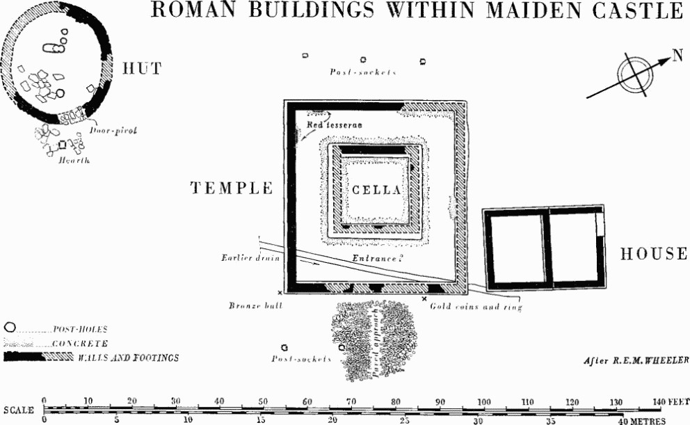
Roman Buildings Within Maiden Castle
The temple (67118846), excavated by E. Cunnington in 1882–4 and by Wheeler in 1934, was of Romano-Celtic type, 43½ ft. by 40½ ft. externally, and terraced into the gentle northerly slope. The cella, 20 ft. by 19½ ft., or 16 ft. square internally, was slightly W. of centre and surrounded by a passage or verandah. A paved approach indicated a central E. entrance, and post-sockets on E. and W. perhaps imply a fence. The walls, largely robbed but uniformly some 2 ft. wide, were of coursed herring-bone flint-work above a levelling course or courses of Purbeck limestone on chalk rubble footings; the external wall survived to 3 ft. on S., but evidence is lacking for use of columns here or elsewhere. The walls were probably plastered on both sides. Plaster of the outer S. wall, originally yellow outside with a basal panel or border of oblique red splashes, had been renewed three times. The W. cella wall had remains inside of mortar rendering with 'roughly stuck' false joints; loose fragments within indicated panels of blue-green, dark red and white, on a mainly terra-cotta ground, while one piece in yellow and black showed two renewals.
No remains survived in 1934 of the 'small portion of black and white tessellated pavement' reported by Cunnington or of his mass of masonry 9 ft. by 6 ft., both apparently in situ in the cella. Cement foundations for such a floor remained, however, over rubble and cement make-up which contained debris and lumps of black and white mosaic border from an earlier building; the surround or verandah had been floored wholly or partly with coarse red tesserae. Both these floors had been largely replaced by reused stone roof-slabs which had possibly formed the original roof of the building, which was probably covered with clay tiles in the second phase.
122 coins were found in and near the building, all save 11 of the 4th century. Several sealed below the floors and paved approach dated the original construction at earliest to 367, and the reconstruction to 379 or later; further occupation was represented by eight Theodosian issues and a hoard of four gold coins of Arcadius and Honorius of c. 405 found with a gold ring beside the outer wall.
A rectangular building (the 'priest's house'; Wheeler, Pl. CXV), 26 ft. by 18 ft. overall and roughly aligned with the temple, lay immediately N.; it consisted of two rooms stepped down the slope, with an entrance in the N. end. The walls 1½ ft. wide were of herring-bone flint-work, levelled with and partly based on limestone courses; it had no surviving floor-surface or wall-plaster. The building contained 4th-century pottery but no coins.
An oval building (67098844; Wheeler, Pl. CXVI) lay on the local hill-crest 12 yds. S.W. of the temple. It was 23 ft. by 21 ft. internally, with rough drystone wall; holes and debris suggested a clay-tiled roof on axial posts. The floor was of limestone roof-tiles and slabs, and had been levelled into that of the largest Iron Age 'C' hut found at Maiden Castle (Wheeler, Pl. XX). A pivot-stone showed the position of a S.E. doorway, outside which was rough paving containing a tile-lined pit-hearth filled with wood ash. As well as cult objects listed below, the hut contained 171 coins mostly of 4th century down to Honorius (393–423); a preponderance of issues of c. 350–360 suggested a slightly earlier period of use than that of the temple.
Discussion. The date of the temple aligns it with others built or restored in Britain in the late 4th century in response to a widespread revival of paganism. Its dedication is unknown, and the small private ex voto objects frequently found on such sites are lacking; nevertheless several objects of dedicatory or cult significance show signs of the syncretism of Roman and native religion. From the temple itself came a fragment of a near life-size bronze statue, a feather-shaped bronze plaque with repoussée figure of Minerva with traces of an inscription (Wheeler, Pl. XXXIX B), and in 1934 a figurine of tinned bronze probably representing the Celtic three-horned bull surmounted by three human busts with bird-like bodies, thought probably all female (ibid., Pl. XXXI B). This figure, and another, in private hands, from Waddon Hill, Stoke Abbot, have been further discussed by F. Jenkins (Dorset Procs. LXXXII (1960), 104–8, fig. 9). From the oval hut came a bronze pedestal for a standing statuette (Wheeler, fig. 97) and the base of another in Italian marble with the feet presumably of Diana and a hound (ibid., Pl. XXXI A).
The objects found in the hut, as well as the quantity of coins, may be cited in support of the view that it served as a shrine, perhaps consciously archaic and continuing a local cult of Iron Age origin, despite the apparent discontinuity of occupation; the importance of the Iron Age 'C' hut which underlay it is evident both from its size and its situation astride or at the head of an Iron Age main street leading from the E. gate (Wheeler, Pl. I), although there is no direct evidence of religious use. If this view is correct, parallels are offered by the 'rotunda' near the temple at Frilford, Berks., overlying an Iron Age penannular ditch (Oxoniensia IV (1939), 11–15), and the polygonal shrine at Brigstock, Northants., in a similar association (Ant. J. XLIII (1963), 235–8). The identification of the small rectangular building as a priest's house, although without obvious parallel, is supported by its division into two small rooms, and by the absence of coins and cult objects.
The inhumation burials. An irregular line of four extended burials (one male, three female) was partly excavated about 150 yds. W. of the temple, overlying the S. ditch of the 'long mound' and close within the original W. rampart, here supposed to form the precinct wall (66988847; Wheeler, Pls. III, V). All were orientated E.-W. with head W., and one at least was not earlier than the 4th century A.D. Fragmentary remains of a child were in the same stratum.
Of earlier burials, in addition to 38 male and female skeletons in the war cemetery of c. 44, 18 inhumations are referred to the Iron Age 'C'/Roman phase, mostly within the outworks of the E. entrance. Some (e.g. T 3–6) were in orderly lines; heads were normally towards N.E., E., or S.E. All save one had limbs flexed or slightly bent, in plain graves accompanied in some cases by vessels or food. The exception was a female fully extended with head S. and hob-nails at feet, accompanied by the headless skeleton of a lamb, in a coffin indicated by iron nails, and with a young dog probably outside the coffin. Interments in the war cemetery, despite evidence of haste, indicated a substantially similar ritual of burial.