An Inventory of the Historical Monuments in Dorset, Volume 2, South east. Originally published by Her Majesty's Stationery Office, London, 1970.
This free content was digitised by double rekeying. All rights reserved.
'Enclosures', in An Inventory of the Historical Monuments in Dorset, Volume 2, South east, (London, 1970) pp. 502-508. British History Online https://www.british-history.ac.uk/rchme/dorset/vol2/pp502-508 [accessed 23 April 2024]
ENCLOSURES
This category embraces earthworks of very diverse form and date. It includes two 'henge' monuments (Dorchester (228) and W. Stafford (24)), three small Bronze Age enclosures, possibly for ritual (Whitcombe (25), Winterborne Came (49) and Winterborne Monkton (11)), and eight small, somewhat angular enclosures, probably prehistoric or Romano-British occupation or stock enclosures. In addition there are three enclosures of possibly later date (Arne (48a), Portesham (56) and W. Lulworth (53e)) and a concentration of seventy-seven circles of unknown date and function (Studland (43)). One enclosure (Portland (98)) has been long destroyed. Some of these enclosures might prove to be settlements, though all certain settlements are discussed under that category. Enclosures of known mediaeval date are described in the parish inventories. Excavation has provided conclusive results only for Maumbury Rings, Dorchester (228).
Arne
Enclosure, see Dykes, Arne (48a).
Chaldon Herring
(58) The Round Pound (SY 78 SE; 79638168), lies at about 480 ft. above O.D. on Chaldon Down, part of an undulating E. to W. chalk ridge here covered by angular flint gravel. The earthwork is on a knoll but with a rise to the S.W. blocking any view towards Portland. Visibility is otherwise extremely good and extends from the Hardy Monument in the W., to Bindon Hill, Flower's Barrow and St. Aldhelm's Head in the E. and to the limits of the chalk downs on the N. The date is unknown; the only evidence is a single sherd of Iron Age 'A' ware with finger-tip decoration found by R.C.H.M. staff scraped from the body of the bank at the W. corner.
A single defensive bank about 36 ft. across at its base and at most 5½ ft. high above the rather dished interior and 10 ft. above an external ditch about 25 ft. wide encloses an irregular, roughly square area of about 1/6 acre with sides 80 ft. to 110 ft. long. The interior ground level is somewhat higher than the outside. The rounded corners at the N. and W. are notably higher than the general run of the sides. The only possible entrance is a dip in the crest of the bank for about 10 ft. immediately S. of the very rounded E. corner. This depression is not certainly original, however, since the scarp of the bank falls for some 4 ft. below it to the outside and perhaps 3 ft. to the inside. The earthwork has been much disturbed and to the E. the ditch, elsewhere almost filled, has been completely obscured.
Dorchester
Maumbury Rings, 'henge' monument, see Roman section, Dorchester (228).
Lulworth, West
Enclosure, butting against bank of dyke on Bindon Hill, see Hill-forts, W. Lulworth (53e).
The Round Pound, Chaldon Herring
Osmington
(42) Enclosure, trapezoidal (SY 78 SE; 75058282), of about ½ acre, sharply angular, with three sides of 140 ft. and one of 170 ft. It lies, almost ploughed out, near Ringstead Barn at about 250 ft. above O.D. on a gentle N.-facing slope, dipping on the W. into a small gully. It is below 'Celtic' fields of Group (12), but remains undated. (R.A.F. V.A.P. CPE/UK 1821: 4442–3.)
Owermoigne
(36) Enclosure, near-rectangular (SY 78 NE; 769880), partly survives in Bowley's Plantation at 200 ft. above O.D. on a plateau (Reading Beds) with ferruginous gravels and sandy clays. The W. part, outside the plantation, has been destroyed by ploughing, but the area enclosed was originally about ½ acre. On the E. is an outer bank, 16 ft. across and 4½ ft. high above a ditch of similar width, with an inner bank, 15 ft. wide and 1 ft. high above the interior. The single causewayed entrance, 10 ft. wide, is slightly S. of centre on the E. side.

Owermoigne
Excavation by Mr. N.H. Field at C-D (Dorset Procs. LXXXI (1959), 102–3; LXXXII (1960), 85) showed the ditch to be V-shaped and 6 ft. deep below the outer bank. Sherds from a bowl in the primary silting were comparable in date with complete Durotrigian jars found upright in shallow pits immediately E. of the bank outside this point. Pollen analysis by Professor Dimbleby suggested open land when the earthwork was constructed and thus a mediaeval or later date. Its form is without any close parallel in the area to give further guidance on the date.
Portesham

Portesham
(56) Enclosure, square, possibly mediaeval or later (SY 68 SW; 64358423), lies on the N.-falling slope of Hewish Hill, a limestone ridge just above 100 ft. A shallow unbroken ditch 11 ft. to 21 ft. wide with no trace of an inner or outer bank bounds an area of just under ½ acre. A drainage ditch running N. to S. continues the line of the W. side and another runs N. from the N. side near the N.E. angle. This angle juts prominently above the level of the ground outside, giving a platform-like effect. Slight scarps run E. to W. across the interior and some small limestone blocks appear in one, to the S., which edges a shallow platform 12 ft. wide. The site is probably that noted in 1923 (Dorset Procs. XLIV (1923), lxix).

(57) Enclosure, angular (SY 68 NW; 61578700), lies S. of Benecke Wood on a gentle S.-facing slope. Only two sides and part of a third remain, consisting of a low bank about 20 ft. across with an outer ditch, all disturbed by gravel digging and solution hollows. The S. part has been destroyed by ploughing. The enclosure might have been connected with ancient fields of Group (5) to the S.
Portland
(98) Enclosure, oval, now destroyed (SY 67 SE; 68987354), lay on the Verne at about 440 ft. above O.D. near the highest point of the Isle of Portland. An unbroken bank with an outer ditch and indications of a counterscarp bank enclosed an area of about ⅓ acre. The defences were best preserved on the W. and external measurements were about 250 ft. by 150 ft. On the S. and W. two terraces continued for some distance northwards and eastwards along the edge of the steep scarp of the hill. To a local antiquary, J. Medhurst, these seemed earlier than the enclosure (C. King Warry, Old Portland Traditions (c. 1908), 15–16). The enclosure was noted as well preserved from the 17th century until its destruction during the building of the fort in c. 1860 when inhumation burials, probably Romano-British, were found in the interior and a flint axe and a ball of chert were discovered in the bank on the S.W. Iron Age and Roman finds have been made nearby to the E. and a hoard of '2,000 slingstones the size of cricket balls' came from the area in 1936. (Hutchins II, 817–18; C. Warne, Illustrations to the History of Dorset, MS. in D.C.M., 251, with plan; Tithe Map of Portland (1839); Dorset Procs. XXXVII (1918), 246; XLIV (1923), 34; Portland Official Guide (1947), 21.)
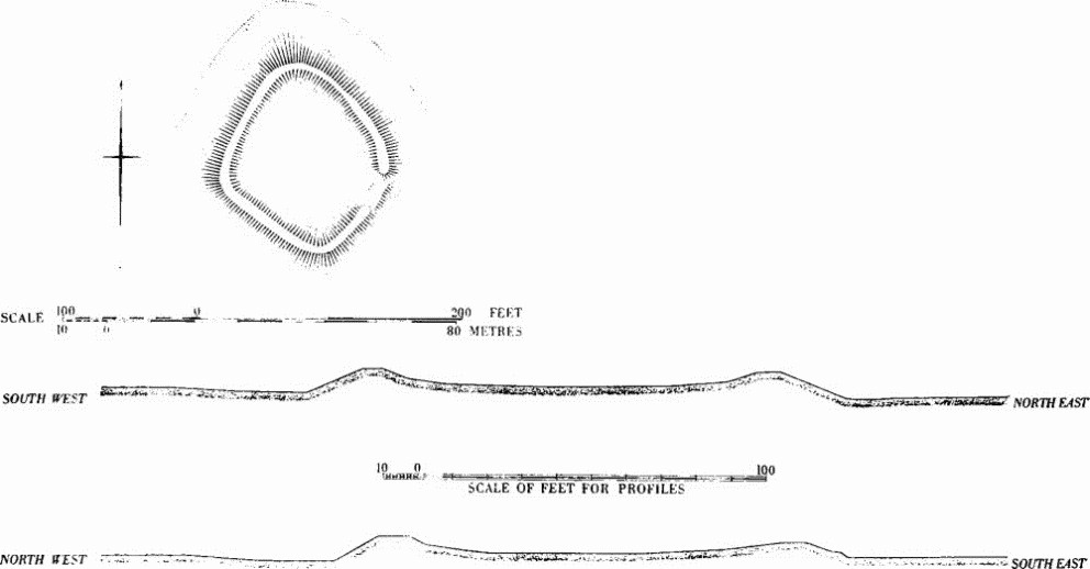
Stafford, West
(24) Enclosure, oval, probably a Neolithic 'henge' monument (SY 78 NW; 710899), lies across a low hill called Mount Pleasant with gentle slopes on all but the N. where the fall, to the R. Frome, is steeper. The enclosing bank only remains on the S. side and the whole site has been heavily ploughed except for the coppice around Conquer Barrow, a large, much disturbed, mound apparently built on the bank at the W.
The bank is of loosely-packed chalk and earth, spread over a width of 50 ft. or more, and, where best preserved, stood about 5 ft. above the old ground surface. Within the bank was a shallow ditch generally 50 ft. to 60 ft. wide. The simple causewayed entrance at the S.E. is certainly original.
Air photographs indicate that when complete the enclosure measured internally about 1150 ft. (E. to W.) by 1000 ft. and covered 12 acres. The area and the position of the existing entrance suggest that it was probably a 'henge' of Atkinson's Class II and would therefore have had an opposed entrance at the N.W., but there are no indications of such an entrance. Warne called it 'Vespasian's Camp' and recorded the finding of 'a sword and a few ancient relics' (Ancient Dorset, 150–1, 242).
Conquer Barrow (22) is about 90 ft. in diameter and lies on the W. bank of the enclosure at the highest point of the hill (see plan). It has a flat top 24 ft. across and on the E. is 7 ft. high above a shelf 24 ft. wide, possibly representing part of the original top of the bank, from which there is another drop to a 'berm' immediately above the inner ditch. On the W. the mound falls 15 ft. without a break to a very disturbed sloping shelf up to 30 ft. wide. A bank 2 ft. high and 10 ft. across runs up to the outer edge of this from the S. This shelf could be due to interference, perhaps deliberate remodelling connected with the name 'Mount Pleasant'. Conquer Barrow is probably a Bronze Age round barrow since its situation on the bank of a Neolithic earthwork has parallels (e.g. Robin Hood's Ball, Shrewton, Wilts.). It is shown without the 'henge' on I. Taylor's one inch map of Dorset (1765). It has been suggested that another barrow (23) existed at the centre of the enclosure but the traces are very slight (R. J. C. Atkinson etc., Excavations at Dorchester, Oxon. (First Report) (1951), 94, 95; S. and C. M. Piggott, Antiquity XIII (1939), 158; R.A.F. V.A.P. CPE/UK 1934: 5081–3; 58/271: 5128–30).
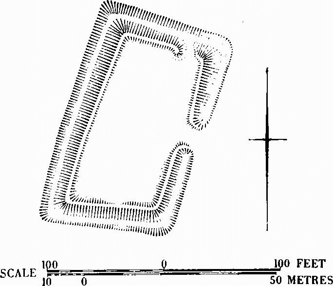
Studland
(43) Circles (SZ 08 NW, SW; Fig. p. 506), occur S.E. of Poole Harbour in two groups: seventy-one on the heath of South Haven peninsula W. of the ferry road (025855 to 029860) and six 1000 yds. S.S.W., just W. of the base of the peninsula (021845). Traces of others, totally destroyed, formerly appeared on air photographs at about 017842 (R.A.F. V.A.P. CPE/UK 1821: 4396 and 6388). They all lie on Bagshot Beds, which at surface levels include sands above an iron-pan, and clays, up to a height of 32 ft. above O.D. Most have single banks about 1 ft. high and 9 ft. to 27 ft. across forming rather irregular circles; the interiors are slightly dished but are all almost horizontal, being built up downhill and cut back uphill if on the slight slope to the Harbour. Diameters between crests vary from 36 ft. to 125 ft. Ten banks have narrow gaps in them, one gap being known from excavation to be original. Many held rainwater for short periods, displaying a wet bog flora; others are heather-covered. One or two circles with relatively deepcut interiors may have been ponds but the function of the others is quite unknown and their date only fixed between the Iron Age and c. A.D. 1700. The northern group are associated with thirteen low sandy mounds but these have also defied explanation. In the centre of the peninsula is a straight line of five regularly placed stones, originally standing upright, with a sixth N.W. of the N. end of the line. (Antiquity XXXVII (1963), 220–3; R.A.F. V.A.P. 540/723: 5040–1 and CPE/UK 1821: 6385–8.)
Whitcombe
(25) Enclosure, D-shaped (SY 78 NW; 70078542; Fig. p. 458, Plate 209), about 100 ft. by 80 ft. with bank and inner ditch each about 13 ft. across, visible on air photographs only. It lies among barrows of the Culliford Tree Group and is apparently cut by ditch of round barrow Whitcombe (14); it is therefore probably of the Bronze Age at latest.
Winterbourne Abbas
(55) Enclosure, irregular and now flattened (SY 69 SW; 60359175), lies near Lankham Eweleaze on the W. shoulder of a spur falling gently to the 600 ft. contour. The subsoil is thick Clay-with-Flints. The enclosure (Figs. p. 507, opp. p. 623) was built over 'Celtic' fields of Ancient Field Group (1), and the N., W. and S. sides are lynchets, low on the S., 5 ft. to 8 ft. high on the W. and built up into a slight bank on the N. The S. part of the bowed E. side had a bank 30 ft. wide and 4 ft. high above a wide external ditch. A later, very slight, bank and ditch run up on to the S.E. corner. In the interior a slight scarp, possibly an earlier lynchet, runs E. to W.; its ends correspond with changes in the form of the E. and W. sides. A very slight scarp runs W.S.W. away from the N. side. The earthwork may be unfinished and is possibly a settlement area of the Romano-British period. Broad ridge-and-furrow, probably mediaeval, lies N., E. and probably S. of it.

Earthworks and Barrow on Mount Pleasant, West Stafford

Earthwork Circles, Studland
Winterborne Came
(49) Ring-work (SY 68 NE; 68728621), 45 yds. E. of the N.E. mound of round barrow Winterborne Came (28). A depression 41 ft. in diam. and 2 ft. deep in centre is surrounded by a bank 25 ft. wide and 1¾ ft. high broken on S.E. by a gap 15 ft. wide, perhaps an original entrance. An external ditch 22 ft. to 28 ft. wide and 9 ins. deep was recently filled on E. with soil from Dorchester containing Roman and later material. Whether the ditch continues across the gap in the bank is unknown. The form and position of the work, within a close-packed barrow group ((AG) Came Down Group, Winterborne Came), suggest kinship with pond barrows or 'henge' monuments.
Winterborne Monkton
(11) Enclosure, horseshoe-shaped (SY 68 NE; 66658920), associated with Lanceborough Group of barrows (AH) (Fig. p. 494). It measures overall about 105 ft. E.-W. and about 93 ft. N.-S. The bank, apparently of chalk rubble, is broken by an entrance on the E. There is no sign of an external ditch but the site has been heavily ploughed.
Winterborne St. Martin
(143) Enclosure (?), irregular (SY 68 NW; 63308664), spans the parish boundary with Portesham, just below 600 ft. above O.D., on the gravel-capped Bronkham Hill where it begins to dip E. and falls sharply N. immediately outside the earthwork. Only the N. and part of the W. side survive, forming an 'angleditch'. On the N. the bank is downhill, 6 ft. across and 1½ ft. high above the silted ditch, 4 ft. across. On the W. the bank is about 17 ft. across, inside and 3 ft. high above a ditch of similar width. Round barrow Portesham (39) (p. 467) and two solution hollows lie inside this 'angle-ditch', which is probably prehistoric.

Winterbourne Abbas (55), see pp. 504–5

Winterborne St. Martin (143)
(144) Enclosure, rectangular (SY 68 NW; 62508734), lies on the E. side and near the S. end of a gully 120 yds. N.E. of round barrow Winterborne St. Martin (32) on Bronkham Hill (Group R.6) and at about 550 ft. above O.D. It is defined by scarps on the N. and W., up to 3 ft. high at the N.W. angle, by a vestigial scarp on the S. and by the steep gully side on the E. The interior, about 1/5 acre in area, falls gently N. In the N.W. angle is an apparent hut-circle with an almost level floor about 15 ft. across and sunk some 3 ft. below the scarp which marks it uphill; it has an entrance 6 ft. wide at the S.E.

Winterborne St. Martin (144)
The enclosure is probably prehistoric. Immediately to the N.E. are fragmentary, very low, rounded lynchets. (R.A.F. V.A.P. CPE/UK 1934: 1066 etc.)
Winterbourne Steepleton
(63) Enclosure, sub-rectangular (SY 68 NW; 60338807), lies 300 yds. N. of the summit of Black Down some 650 ft. above O.D. and within the N.W. angle of the cross-roads (Fig. opp. p. 624). It lies on a gentle slope on pebble gravel of the Bagshot Beds. A bank about 14 ft. across rises some 1½ ft. above the interior and about 4 ft. above an outer ditch some 14 ft. wide with traces of a counterscarp bank. The interior is flat, ¼ acre in extent, and may have been sub-divided. The simple gap and causeway entrance is midway along the E. side.
Winterbourne Steepleton