An Inventory of the Historical Monuments in Dorset, Volume 2, South east. Originally published by Her Majesty's Stationery Office, London, 1970.
This free content was digitised by double rekeying. All rights reserved.
'Dykes', in An Inventory of the Historical Monuments in Dorset, Volume 2, South east, (London, 1970) pp. 515-519. British History Online https://www.british-history.ac.uk/rchme/dorset/vol2/pp515-519 [accessed 24 April 2024]
DYKES
The dykes described in this Volume are classified as linear dykes or cross-ridge dykes. The former are generally longer and more irregular than the latter which run approximately at right angles across a ridge or spur.
Linear Dykes: four of the nine examples are clustered together on Worgret Heath (Arne (48)). Another, mostly outside the Volume boundary (Winterbourne Steepleton (66)), is the only one to be dated even approximately: it appears from an R.C.H.M. excavation to be of the Late Bronze Age. Attached to it is a small enclosure recalling a similar relationship of this period on Boscombe Down East, Wilts. (fn. 1) This is the only example which warrants any comparison with the linear ditches of N.E. Dorset and beyond, and even so, seems to form no part of a large enclosure as would be usual with a 'ranch boundary'. Doubtful analogy suggests that the only multiple examples, amongst the Worgret Dykes, are Romano-British. Battery Bank (E. Stoke (50)) by its possible length of over 3 miles suggests comparison with boundary works like Comb's Ditch 4 miles S.W. of Blandford (to be described in Dorset III) or the late Roman but much bigger Bokerley Dyke. None of the single banks and ditches exceeds 53 ft. in maximum overall span (Battery Bank) and only one has a depth, from crest of bank, approaching 8 ft. Most are much less, the very curious Winterborne St. Martin (145) being the smallest.
Linear Dykes W. of Wareham. Arne (48), East Stoke (50)
Cross-ridge Dykes: all ten are on chalk and eight are probably Iron Age. Five, on Knowle Hill (Church Knowle (56)), are arranged in a coherent pattern around a proved Iron Age 'A' settlement, which strongly suggests that they could have been developed into a small hill-fort with outlying dykes. The hill-fort of Flower's Barrow actually has such an outlier (E. Lulworth (41)). This is considerably smaller than the relatively massive dyke, Weymouth (436), that may have converted the Windsbatch spur into a promontory fort, rather as W. Lulworth (53b) cut off the W. end of Bindon Hill.
Winterborne Monkton (12) is anomalous in that, although it crosses a spur from combe to combe, the even and gentle fall of the spur and the presence of barrows on one side and former open field on the other leave its function and date quite uncertain. Portesham (62) could be recent.
Arne
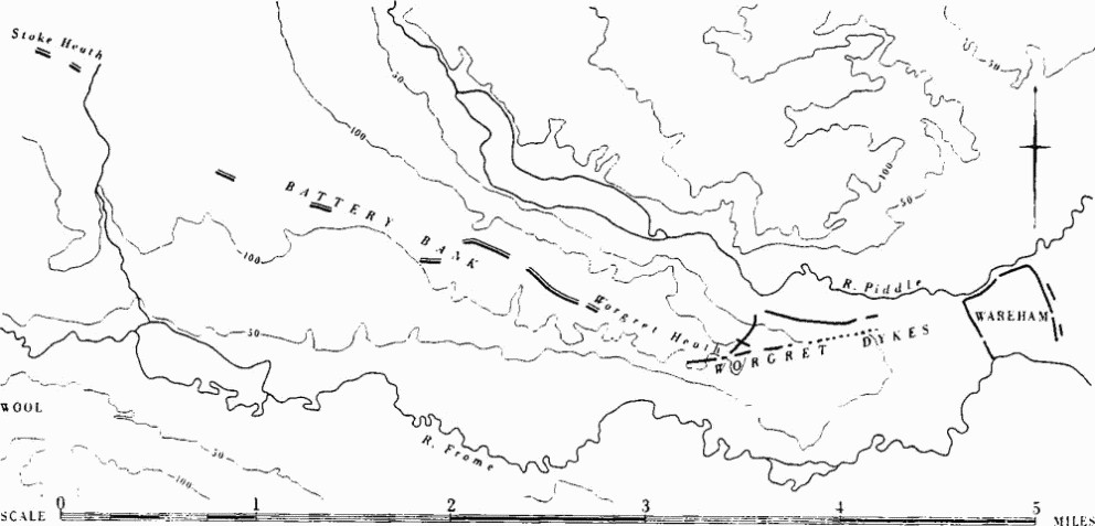
(48) Linear Dykes, four, on Worgret Heath and Wareham Common, partly in the parish of Wareham Lady St. Mary (SY 88 NE, 98 NW; 89638705 to 91218745). This complex lies on gravels and sands, now mostly heath and poorly drained, between the rivers Piddle and Frome (Fig. above). The W. end is 1½ miles due W. of Wareham and about 750 yds. S.E. of the first of a series of discontinuous lengths of dyke, all facing N., known collectively as Battery Bank (see East Stoke (50)). There seems to be no necessary connection between these two sets of earthworks.
The dykes are of different forms but their siting is nowhere tactical and they appear to be boundaries forming barriers to movement, possibly of cattle, rather than defences. Alignment (c) differs from (a) and (b) in situation, however, while only (b) has double ditches. The fragmentary bank-and-ditch (d) cuts through (b) and may conceivably be connected, from its alignment, with Battery Bank. The line of earthworks shown on O.S. maps N. of the W. end of (a) appears to be the result of gravel digging.
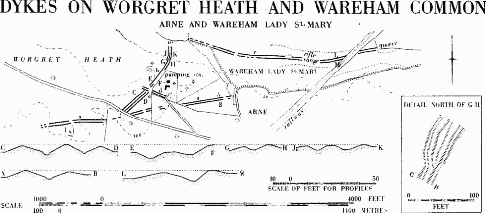
Dykes on Worgret Heath and Wareham Common, Arne and Wareham Lady St. Mary
The date of the dykes is uncertain. The nearest possible analogy for the variably multiple form is on the chalkland of Cranborne Chase, where the dykes are possibly Romano-British (D. W. Harding, Dorset Procs. LXXXI (1959), 110–13). If (d) can be connected with Battery Bank, then (b) would have gone out of use when Battery Bank was built.
(a) consists of two banks, some 1½ ft. high, on either side of a narrow-bottomed ditch 4 ft. deep; the overall width is 45 ft. It runs N.E. for about 1000 yds. from a re-entrant gully and is now broken by two wide gaps. There are faint traces at the N.E. end of a link with the present Arne-Wareham parish boundary which continues the alignment for 4/5 mile. Near the S.W. end, on a plateau 100 ft. above O.D., discontinuous banks about 1 ft. high, double on the E., spring from the S. side and might have formed a trapezoidal enclosure (x), measuring some 120 ft. (E.) by 225 ft. (N.).
(b) is of varied form: for the first 200 yds. triple banks contain two ditches, the whole being 62 ft. wide, but after being cut by (d), there are first two ditches and two banks, then one bank between two ditches, then one ditch between two banks and finally three banks and two ditches, 50 ft. overall (for junction between these last two forms, see detail on plan). It runs N.E. and then N. for about 400 yds. from the modern road near a gap in (a) to a scarp 10 ft. high falling to the flood plain of the river Piddle.
(c) consists of double banks with a ditch between them, the whole varying in width from 45 ft. to 55 ft. In places the ditch is up to 5¾ ft. deep below the banks but recent excavation of a field drain along part of it may point to similar scourings in the past. A recent cut near the rifle butts suggested the possibility of a flat bottom 7 ft. below the top of the banks (Dorset Procs. LXXVIII (1956), 78). The dyke follows the low-lying terrace approximately parallel to the river Piddle for 860 yds. from a point 200 yds. E. of the N. end of (b) and may have continued further W. on the line of the ArneWareham parish boundary. The rifle butts and much of the length E. of them have recently been destroyed (Dorset Procs. LXXXI (1959), 108); a large field bank continued the line further E. towards the N.W. angle of Wareham defences.
(d) is a bank 3 ft. high with a ditch and counterscarp bank on the N., about 30 ft. wide overall, and cuts (b) at right angles. It projects only a few feet to the N.W. but traces exist to the S.E. for about 100 yds.
Bere Regis
(119) Linear Dyke (SY 89 NW; 81389644–81889701) runs along the parish boundary with Milborne St. Andrew, down the sides and across the bottom of the small dry valley followed by the Bere Regis-Milborne road. To S.W., it begins about 610 yds. S. of the road, in the centre it is broken for about 25 yds. either side of the road, and it apparently ends about 230 yds. N. of the road. The ends are ill-defined, owing to an overlying (manorial?) boundary bank, which continues the line to the S.W. The dimensions vary along the dyke's length, but at most it is 23 ft. wide and 6 ft. high; throughout, it is higher above present ground level on the W. than the E., suggesting a ditch on the W. and uphill side. Towards its S.W. end, the bank is crossed by a double-lynchet track running past the probable settlement in Ancient Field Group (30). (Warne, C.T.D., cpf, barrow no. 2.)
Church Knowle
(56) Cross-ridge Dykes, five, on Knowle Hill (SY 98 sw; Fig. opp. p. 509, Plate 212), are of varying form; (c) and (d) are complex. Some or all are likely to be contemporary with the Iron Age 'A' settlement, Church Knowle (54), which lies between (c) and (d), the ditches of all the dykes being on the side distant from it. The apparently unfinished works along the N. shoulder between (c) and (d) suggest that there may have been an intention to enclose this area.
(a) (93088211) is much disturbed by a quarry on the S. but runs 100 ft. to the edge of the ridge on the N. The bank is about 15 ft. across and now up to 3 ft. high above its ditch, 10 ft. wide. A slighter bank, 12 ft. wide and 1 ft. high, also with a ditch on the W., joins the dyke at the N. and bends slightly W. before running down to the foot of the steep slope. Burials, probably Roman, were found to the E. (Roman section, Church Knowle 59).
(b) (932821), 130 yds. E. of (a), is 150 ft. long, rising diagonally across the ridge from a broken edge on a quarry at the S. to the shoulder above the steep slope on the N. The bank is 23 ft. across and about 2½ ft. above the ditch, 13 ft. wide. The modern ridgeway track crosses it. 55 yds. to the E. a sharply defined shelf crossing the ridge is modern.
(c) (93378217), 200 yds. E. of (b); two banks with a ditch between, about 160 ft. long, span the hilltop where it is still rising to the settlement area (54). A gap in the banks 100 ft. from the S. end corresponds with an original causeway. The ditch is here 22 ft. wide, notably wider than elsewhere and 8 ft. below the E. bank. The W. bank, about 25 ft. wide and nearly 3 ft. high from the W., is bowed markedly W. At the N. end the outer scarp swings sharply E. and is continued as a terrace about 10 ft. wide, possibly the first stages of ditch construction, for 400 ft. (fn. 2) The E. bank is about 28 ft. wide.
(d) (93658228), 320 yds. E. of (c), spans the hilltop and is bowed to the E. The bank is 3½ ft. high from the W. and 4½ ft. above E. ditch, but probing suggests the ditch is at least 3 ft. deeper than this. The present break in the dyke is secondary; uninscribed mere-stones formerly lay on either side of it. The dyke seems to end about 50 ft. short of the edge of the really steep slope to the S. but on the N. ran up to the edge, making a junction (obscured by the later hedge bank) with another length of dyke, its ditch on the uphill side, which then runs W. for 200 ft., oddly veering away from the edge.
(e) (94398235), 810 yds. E. of (d), is 270 ft. long with an original gap near the centre, now widened. It has long been ploughed but its dimensions were probably similar to (d): there is an apparent constriction of the ditch 60 ft. S. of the entrance. A round barrow (Church Knowle (40)), immediately E., appears to extend into the ditch but the excavator's note that he threw soil to the W. may explain this (Purbeck Papers I, 110–15). The dyke ends on the shoulder of the steep slope to the N., but 200 ft. short of the corresponding edge to the S.
Lulworth, East
(41) Cross-ridge Dyke, E. of Flower's Barrow (SY 88 SE; 868806) and partly in Tyneham parish, see Hill-forts, East Lulworth (40).
Lulworth, West
Cross-ridge Dyke, on Bindon Hill (SY 88 SW; 82688020), see Hill-forts, West Lulworth (53b).
Owermoigne
(37) Linear Dyke, on Owermoigne Heath (SY 78 NE; 78138790–?78058769). In an area scarred by gravel quarrying a bank and ditch are aligned N.-S. along the W. edge of a low plateau sloping gently southwards at about 150 ft. above O.D. The subsoil is Bagshot Beds, now with a thick scrub cover. The dyke is 270 ft. long, with a modern break near the centre: its ditch, on the W. side, is 14 ft. across, its bank 18 ft., rising from 6 ft. to 8 ft. above the ditch bottom. The S. end has been destroyed by quarrying but in a field immediately S. of this, and ploughed almost flat, are traces of a bank and ditch, the ditch on the W. side, extending S.S.E. for about 250 ft.
Portesham
(62) Cross-ridge Dyke, on Friar Waddon Hill (SY 68 NW; 64258542), a bank and ditch about 70 yds. long, is aligned N.-S. across the axis of the limestone ridge at about 400 ft. above O.D. It lies on a gentle S.-facing slope and extends from the edge of the steep S. face of the ridge to its summit. The bank is 14 ft. across and 1 ft. high, the ditch, to its E., 14 ft. across and about 1½ ft. deep; 3 yds. beyond the N. end of the bank is an irregular mound, not a barrow, 20 ft. across and 2½ ft. high. Level with the N. end of the bank the ditch is shallower and turns sharply eastwards for some 20 yds., running under a stone field wall before being lost in very disturbed ground. It may be related to the 'Celtic' fields of which faint traces are discernible all over the hill-top, but there is no visible connection.
Linear Dyke, on Bronkham Hill, see Winterborne St. Martin (145).
Stoke, East
(50) Battery Bank, a series of discontinuous stretches of dyke (SY 88 NW, NE; 844894–891874), runs S.E. towards Wareham along a heathland ridge 150 ft. above O.D. (plan p. 516). At the S.E. end the earthwork is on the ridge crest but at the N.W. it is on the S. slopes. The remains consist of a bank 20 ft. to 33 ft. wide and 1 ft. to 2 ft. high with a ditch on the N. 18 ft. to 20 ft. wide and 1 ft. to 1½ ft. deep. The surviving lengths, possibly once continuous over 31/5 miles, have been much damaged, especially by gravel quarrying; none of the gaps is certainly original. There is no certain connection between this boundary dyke and the complex on Worgret Heath (Arne (48)) commencing 750 yds. from its S.E. end.
The lengths are as follows: (a) of 300 yds., very slight and mostly only traceable on air photographs (R.A.F. V.A.P. CPE/UK 1934: 5063), runs from about 84438941 to 84658929; (b) of 200 yds. from 85788863 to 85948853; (c) of 230 yds. curving from 86558831 to 86768828; (d) of 220 yds. from 87478787 to 87688787; and (e) of 1500 yds. from 87828800 to 89068743.
Wareham Lady St. Mary
Linear Dykes, on Wareham Common, see Arne (48).
Weymouth
(436) Cross-ridge Dyke, on Windsbatch (SY 68 NE; 65748504 to 65778517), a bank 30 ft. across and some 8 ft. above a W. ditch 30 ft. wide, is bowed slightly E. and virtually cuts off the E. end of the limestone ridge. Its S. end is on the 300 ft. contour, at the edge of a very steep slope (an apparent continuation downhill is a small boundary bank of later date built in the ditch and continuing its line); 240 ft. to the N. is a gap, probably original, 16 ft. across. A less clear length of bank running for some 90 ft. N. of this gap ends a little way down the rounded shoulder of the hill where there is much old quarry disturbance. The N. slope is only notably steep E. of the dyke, which is therefore defensive in situation as well as size. There are slight banks and scarps in the 8 acres of ridge top to the E. but the area is very disturbed. Immediately N. of the ridge are faint traces of 'Celtic' fields broken down by strip ploughing before the whole area was flattened by more recent cultivation.
Winterborne Monkton
(12) Cross-ridge Dyke, traces of bank and ditch (SY 68 NE; 66808932 to 66798902; Fig. p. 494), lies between 200 ft. and 300 ft. above O.D., spanning the forward slope of a low broad spur between two gullies; the bank with a ditch on its W. side, now in arable land and almost totally flattened, ran approximately N.-S. for 1620 ft. The northern 630 ft. is visible on air photographs only (R.A.F. V.A.P. CPE/UK 1934: 3089). A portion of mutilated bank measured before ploughing was 18 ft. across and 1½ ft. high; when later seen spread in plough-land the bank was about 36 ft. across and the ditch was 18 ft. across.
Date and purpose are both unknown. The dyke changes direction as it passes a round barrow (Winterborne Monkton (7)) and is probably later than it. The form, with a ditch uphill, is unusual in this area but has affinities with cross-ridge dykes elsewhere, e.g. in Sussex, associated with 'Celtic' fields. Immediately N. of it was 'Ditch End Furlong' of Fordington open field (Tithe map 1844). It was conceivably built to bound arable fields and to preserve the barrows (Lanceborough group) on the spur, whether in the mediaeval period or earlier.
Winterborne St. Martin
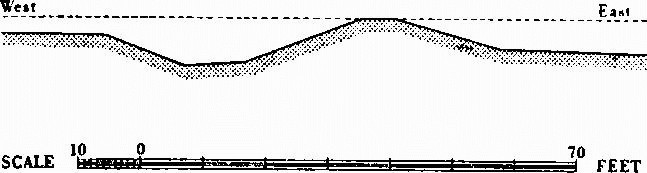
(145) Linear Dyke, on Bronkham Hill (SY 68 NW; 62558680 to 62948675; Plate 209). Running athwart the Ridgeway and cutting over round barrow Winterborne St. Martin (47) is a single bank, at most 14 ft. across and 1½ ft. high, with a ditch on the N. Short erratic stretches link solution hollows— but do not run down into them as do later banks—from a point about 230 yds. W. of barrow (47) to about 185 yds. E. of it. The dyke climbs the S. face of the ridge (in the parish of Portesham), and is crossed by the present stone wall on the Winterborne St. Martin boundary and by another running up to the boundary. The bank appears to consist solely of the gravel of the underlying Bagshot Beds. The barrow is the only feature which clearly ante-dates it, and the fact that it mutilates the barrow strongly suggests a Romano-British or, probably, later origin, while its disregard for the parish boundary could point to a date before the formation of the parishes.
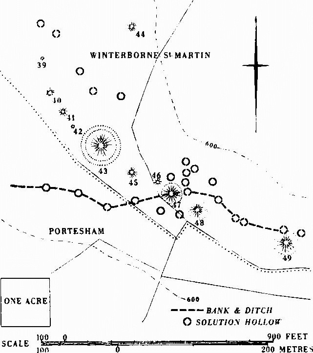
Dyke, Winterborne St. Martin (145), with part of Bronkham Hill Barrow Group (R. 6).
Winterbourne Steepleton
(66) Linear Dyke, on Black Down (SY 68 NW; 60078795 to 60568793), within Ancient Field Group (3), runs E.-W. for 530 yds. from just below 700 ft. to about 575 ft. O.D. (Fig. opp. p. 624). To the W. it passes into Little Bredy parish where a small enclosure (Dorset I, Little Bredy (6)) is attached to it. W. of the enclosure it extends downhill along the N.-facing slope of a re-entrant valley, first as a ditch with a bank on the S. side, then as a soil-mark, then as a depression 15 ft. wide, and finally as a narrow sloping terrace which fades into the hillside below a 'Celtic' field scarp. E. of the enclosure after a 14 yd. gap, perhaps due to quarrying, the dyke continues uphill, first as a depression then, E. of the parish boundary, as a ditch with a bank on its N. side.
Small-scale excavations on the dyke where it forms part of the enclosure (by R.C.H.M. in 1956) showed that the bank was 12 ft. across and only 1 ft. high, while the ditch was 9 ft. across the top, 2 ft. across the bottom and 3 ft. deep. A few coarse undecorated sherds from the ditch filling might indicate a date in the Late Bronze Age.