An Inventory of the Historical Monuments in Dorset, Volume 3, Central. Originally published by Her Majesty's Stationery Office, London, 1970.
This free content was digitised by double rekeying. All rights reserved.
'Ibberton', in An Inventory of the Historical Monuments in Dorset, Volume 3, Central, (London, 1970) pp. 123-125. British History Online https://www.british-history.ac.uk/rchme/dorset/vol3/pp123-125 [accessed 16 April 2024]
In this section
25 IBBERTON (7807)
(O.S. 6 ins. ST 70 NE, ST 80 NW)
The parish extends over nearly 1,400 acres and straddles the main Chalk escarpment which at this point stands 300 ft. high. The E. half of the area is a broad dry valley draining E. down the dip-slope of the Chalk from 700 ft. to 500 ft. above sea-level. The W. half, below the escarpment, undulates gently between 300 ft. and 400 ft. on Gault and Kimmeridge Clay. The village lies on the spring line at the foot of the escarpment, at the junction of the Greensand and Gault. Marsh Farm and Leigh Farm seem to be secondary settlements; the former is first recorded in the 14th century. (fn. 1)
Ecclesiastical
(1) The Parish Church of St. Eustace stands above the village, on the steep hillside to the S. It has walls of banded rubble and flint, with ashlar dressings, except for the tower which is of squared rubble and ashlar; the roofs are tiled. The building was in an advanced state of decay at the end of the 19th century and extensive restorations were effected c. 1903, but the main fabric is of the middle of the 15th century. It consisted originally of a Chancel and Nave; the North Chapel and the West Tower were early additions, and the nave arcade and the North Aisle were built in the first half of the 16th century.
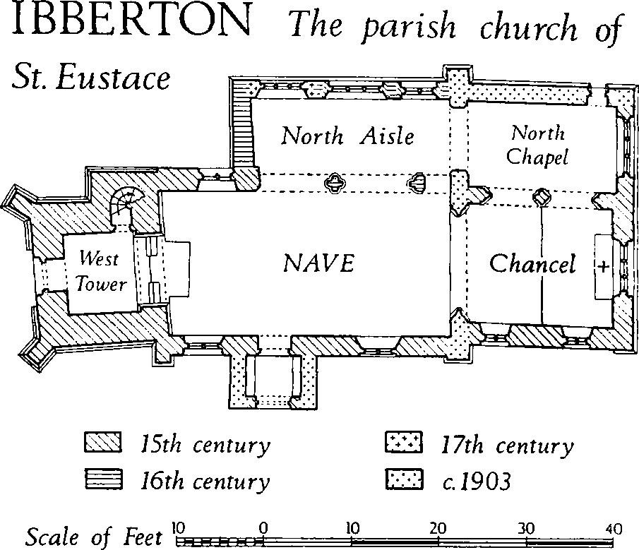
Ibberton, the Parish Church of St. Eustace
Architectural Description—The Chancel (16½ ft. by 13½ ft.) has a 15th-century E. window of three cinquefoil-headed lights with outer casement mouldings; it was originally square-headed but was provided with a pointed head and intersecting tracery c. 1903, the original square head being retained as a transom. In the N. wall is a two-bay arcade to the N. chapel; the two-centred arches have been retooled but the masonry is substantially of the 15th century. The arches consist of two ogee-moulded orders separated by a hollow-chamfer which continues on the responds and central column. The inner order is carried on attached shafts while the outer orders have shafts on the column but continue as ogees on the responds; the shafts have plain conical caps and polygonal bases. In the S. wall are two square-headed windows, each of two cinquefoil-headed lights with hood-moulds; that to the E. has a segmental rear arch and a sill about 1 ft. higher than that to the W. The chancel arch is of c. 1903.
The North Chapel (17 ft. by 10 ft.) has a gabled E. wall continuous with that of the chancel; in it is a restored three-light E. window similar to that of the chancel, but square-headed. The N. wall, rebuilt c. 1903, includes a reset late 15th-century doorway with a four-centred hollow-chamfered and casementmoulded head, continuous jambs and a square label. On the W. side of the chapel an archway of c. 1903 leads into the N. aisle.
The Nave (32¾ ft. by 16½ ft.) has, on the N. side, a 16th-century arcade of two bays augmented to the E. by a small modern archway cut through the respond. The arcade has segmental-pointed arches composed of two chamfered orders. The same orders continue in the form of polygonal shafts with chamfered and wave-moulded capitals on the E. respond and central column, but the W. respond, which is formed from the original N. wall, has the outer chamfer of the arch repeated on its S. face only; a wave-moulded corbel supports the inner order. W. of the arcade the N. wall is pierced by a square-headed 15th-century window of two cinquefoil lights with a square label with headstops: to the E. a woman wearing a head-dress, to the W. a man in a cap. The S. wall of the nave has a square-headed window of two cinquefoil lights on each side of the doorway; that to the E. has an ogee-moulded external surround while that to the W. has casement mouldings; both windows have restored labels with square stops. The S. doorway has a two-centred chamfered head with continuous jambs and a hollow-chamfered segmental-pointed rear arch.
In the North Aisle (22¾ ft. by 8½ ft.) the lower courses of the N. wall are built with heavy ashlar blocks, forming a chamfered plinth. A modern two-stage buttress marks the junction of the aisle and the N. chapel. In the E. part of the aisle wall is a reset 15th-century window of two cinquefoil-headed lights in a square-headed casement-moulded surround, with no label. Near the middle is another reset 15th-century window of three cinquefoil ogee-headed lights with a chamfered square-headed surround with no label; this window is said to come from Milton Abbey. Further W. is a 17th-century window of three square-headed lights. The gabled W. wall of the N. aisle has no openings.
The West Tower (9¼ ft. by 8½ ft.) is of two stages with an embattled parapet. At the base is a moulded plinth; the stages are divided by a weathered string-course and the parapet has a roll-moulded and hollow-chamfered string-course. The stringcourses continue around the vice turret, which has three main stages; it stands at the N.E. corner and its embattled parapet is slightly higher than that of the tower. The lower stage of the tower has diagonal N.W. and S.W. buttresses of three weathered stages, and a similar square-set buttress at the S.E. corner. The tower arch is two-centred and of two wave-moulded orders; the outer moulding continues on the responds and ends in shaped stops; the inner moulding dies into the responds at the springing. The vice doorway has a chamfered segmental-pointed head. The W. doorway has a casement-moulded segmental-pointed head with continuous jambs and a segmental-pointed rear-arch. Above it, the W. window has three cinquefoil-headed lights under a two-centred head with vertical tracery, a casement-moulded surround and a hollow-chamfered hood-mould; the rear-arch is two-centred and hollow-chamfered. In the upper stage of the tower each side has a belfry window of two cinquefoil-headed lights under a square head and label. The South Porch is largely rebuilt, but the two-centred hollow-chamfered arch with continuous jambs has original plinths and includes portions of original voussoirs, one scratched '1636'.
Fittings—Bells: four; treble inscribed 'Joseph Daubeny Esqr. 1799, Thomas Mears of London fecit'; 2nd inscribed 'TP. RR. TA. cw. ANNO DOMINI 1656'; 3rd inscribed 'Richard Rogens, Allen Hayne, Churchwardens, 1641, W.P.'; tenor by James Wells of Aldebourne, 1813. Book: Chained, leather-bound book of homilies, 1673. Brass: In floor near N. respond of chancel arch, to Joseph D'aubeny, 1817. Chair: In chancel, with turned legs, shaped arms, carved back panel and frame, 17th century. Coffin Stools: Two, with beaded uprights and stiles, late 18th century. Communion Table: In N. Chapel, with turned legs and fluted front and side rails, early 17th century; top modern. Font: Octagonal stone bowl with vertical sides, and chamfered and undercut mouldings below, each side with a trefoil-headed panel, much worn, on octagonal stem and moulded octagonal base; 15th century. Glass: In chancel, in E. window, reassembled fragments and two roundels; in S. window, shield-of-arms of Milton Abbey (Plate 144), with letters I and T in border, perhaps for John Towninge, rector 1452–1478, and in cusping, a rose and a sun. In N. aisle, in N.E. window, oval panel of strapwork enclosing shield with Tudor rose and letters E.R., 16th century; in adjacent light, larger panel displaying royal achievement-of-arms of Elizabeth I, 16th century (Plate 44); in N.W. window, three quarries, one inscribed 1588, one with three battle-axes, one with a shield with three stars, probably late 16th century. In nave, in N. window, crowns, roses and other fragments; in S.W. window, a sun; probably 15th or 16th century. In tower, in W. window, tracery lights with tops of scrolls, probably 15th or 16th century.
Monuments: In chancel, on S. wall, (1) of Richard Daubeney, rector, 1802, wall-tablet of variegated marbles with pediment. In N. chapel, on N. wall, (2) of Richard Applin, 1792, marble tablet; (3) of Richard Seymer, 1785, marble tablet; (4) of Mary Galton, 1758, marble wall monument with vase in broken pediment, and cherub-head on shaped apron, also later inscription commemorating donor, C. Elswood, 1774, rector. In nave, on S. wall, (5) of Elizabeth Davis, 1842, marble tablet by 'Patent Works, Esher St. West'r'. Piscina: On S. side of chancel, with cinquefoil cusping in hollow-chamfered two-centred head with continuous jambs and broach stops, three-sided projection to bowl; 15th century. Plate: includes a heavy and plain silver cup with straight-sided conical bowl and tapering stem on domed base; date-letters of 1632, churchwardens' initials and date 1686. Royal Arms: Above E. window of N. chapel, arms of George III on shaped panel inscribed 'Jos. D'aubeny Esqr. 1801'. Screen: In tower arch, early 17th-century panelled oak screen, 6 ft. high, in three heights; upper height comprising turned balustrade. Tables of Decalogue: In tower, incised on two stone panels, late 18th or early 19th century. Tiles: In pavement of S. porch, slip tiles with various patterns, much abraded; 15th century.
Secular
(2) The Manor House (78940774), 200 yds. N. of the church, is a mid 17th-century farmhouse of two storeys with walls of banded flint and ashlar and a modern slated roof. The plan consists of one room on each side of a central entrance passage, with a service wing behind; the fireplaces are in the end walls. A 19th-century addition, recently refaced, extends the original range westwards.
The original S. front is of three bays, having a doorway flanked symmetrically by four-light casement windows with square heads and hollow-chamfered stone surrounds, and three similar three-light windows above. The central doorway has a hollow-chamfered and ogee-moulded four-centred head, continuous jambs and roll stops; it is sheltered by a gabled ashlar and rubble porch with a round-headed archway. A reset stone in the porch bears the dates 1666 and 1686. The E. wall of the house is banded like the S. front but the chimney-stack on the gable has been rebuilt in brick; the original W. wall is hidden by the 19th-century extension. The 17th-century nail-studded front door is of two layers of oak planks, vertical outside and horizontal inside, hung on wrought-iron strap-hinges. The central passage is separated from the ground-floor rooms by plank-and-muntin partitions with chamfered bottom rails and moulded top rails. The ground and first-floor rooms in the original range have ceiling beams with double roll-mouldings. One room has 18th-century fielded panelling.
(3) Cottage, 50 yds. W. of (2), is of rubble, mainly rendered, and has two storeys and a thatched roof; it is of 17th-century origin but has been extensively restored. The doorway and one casement window in the N.E. front retain original chamfered oak surrounds. The entrance passage is flanked by plank-and-muntin partitions.
(4) Barn (78760796), 300 yds. N.W. of (2), is of banded flint and rubble and dates from the late 17th or early 18th century.
(5) Cottages, range of four (78770778), with walls of rubble and brick and with thatched roofs, are of 18th-century origin. They were formerly single-storied with attics but an upper storey was added, probably in the 19th century. (Demolished.)
(6) Inn (78780777), originally two cottages, is of the early 19th century but incorporates a late 17th-century door, of elm planks in two thicknesses fastened together with wrought-iron studs.
(7) Cottage (78740780) is of brick in two storeys with a thatched roof and dates from the late 18th century. The symmetrical three-bay E. front has a recessed panel over the doorway and blue-brick chaînage at each corner.
(8) Cottage, 100 yds. N. of (7), of one storey with an attic, is of the 18th century.
(9) Cottages, pair, at Leigh Farm (78370869), are onestoried with dormer-windowed attics and have rendered rubble walls and thatched roofs; they date from the middle of the 18th century but the upper floors have been rebuilt.
Early 19th-century monuments in the parish include the house at Leigh Farm (78390871) and three two-storied cottages with brick walls and thatched roofs, dispersed in the village.
Mediaeval and Later Earthworks
(10) Cultivation Remains. Nothing is known about the open fields of the parish but, upon the evidence of the remains of strip fields, indented modern field boundaries and the situation of apparently secondary settlements, they must have been in two separate areas. Some lay around the village, at the foot of and on the Chalk scarp, while others were on the dip-slope in Coombe Bottom a mile to the S.E.
On the steep Chalk scarp immediately N.E. of the church a group of eight contour strip lynchets covers about 22 acres (791077). Originally the strips were up to 400 yds. long with risers up to 18 ft. high, but extensive alterations were made to the group before 1840, as a result of enclosure. Two of the fields, 'Cross Lands' on the Tithe Map of 1840, are laid out across the risers of the original strips, and subsequent ploughing in these fields has produced secondary risers cutting obliquely across the older treads. Some 500 yds. S.E. of the church, also on the scarp slope, further contour strip lynchets overlie 'Celtic' fields (see Group 54).
In Coombe Bottom (801071 and 804071) at least five fragmentary contour strip lynchets lie within an area which, to judge by the shape of the existing boundaries, was once an open fields. N. and N.W. of these, on the steep hill-side (803074), are very slight contour strip lynchets with low risers, apparently outside the permanent open fields.
Roman and Prehistoric
(11) Settlement, Romano-British, on South Down (80530692), has been destroyed by ploughing. It lay at 625 ft. above O.D., overlooking a dry valley, on the N. shoulder of a spur dropping eastward from the main Chalk escarpment. The site, already ploughed when investigated, included a small group of platforms, three certain and two probable, levelled into the slope; they measured about 20 ft. across and were backed by curving scarps. About 90 yds. E. of the platforms and probably associated with them was a small enclosure of 1/8 acre, with four unequal sides, rounded corners and an entrance on the S. It was defined by a low bank up to 2 ft. high and 15 ft. across, with an external ditch, most clearly marked on the S. Coarse Romano-British pottery and a few samian fragments were found in the platforms but none was found in the enclosure. 'Celtic' fields which surround the settlement site are directly related to the enclosure.
'Celtic' Fields, see p. 339, Group (54).
(12), (13) Cross-Dykes, two, lie across the ridge top at the summit of the Chalk escarpment. The first runs W.N.W.—E.S.E. (78800643–79080638) slightly obliquely across the ridge between Chitcombe Down and a combe to the E. It is univallate and about 325 yds. long, with a ditch on the S. side, but it is now almost completely ploughed out. At the E. end, about 30 yds. remain; the low bank is 20 ft. across and the ditch is 15 ft. across and 1 ft. deep. A possible break N. of centre is suggested by air photographs (R.A.F. CPE/UK 1934 2172–3).
The second dyke, 1 m. N.E. of the first, runs N.W. to S.E. (79590807–79760787) at about 800 ft. above O.D. across the ridge top, on ground falling S.W. from Bell Hill; the dyke faces the higher ground to the N.E. It is about 315 yds. long, with a bank some 22 ft. across and 3 ft. to 4 ft. high, and a ditch of about the same width and depth. Except towards the ends, a low counterscarp bank is visible; it is nowhere more than 1 ft. high and 5 ft. wide. There are three differently aligned lengths; at the N.W. end, where the dyke runs out on the steepening slope, a length of 165 yds. extends S.E.; a central length of about 33 yds. is aligned N.—S.; to the S. is a length of some 116 yds. running N.N.W.—S.S.E. and fading out on the well-marked shoulder of a S.—facing slope, along which runs a track. The abrupt change of alignment where the present ridgeway track passes obliquely through the central length suggests an original entrance. The parish boundary with Okeford Fitzpaine is marked by a bank about 3 ft. wide and 1 ft. to 2 ft. high which runs along the ditch of the N. length, and continues down the hill.
(14) Barrow ? (79200723), on Ibberton Hill at about 750 ft. above O.D., on a N.W. slope near the spine of a ridge, is now roughly D-shaped on plan, probably owing to destruction by a trackway on the S.E. There appears to have been digging at the centre. Diam. (S.W.—N.E.) 54 ft., ht. 3½ ft.