An Inventory of the Historical Monuments in Dorset, Volume 3, Central. Originally published by Her Majesty's Stationery Office, London, 1970.
This free content was digitised by double rekeying. All rights reserved.
'Tincleton', in An Inventory of the Historical Monuments in Dorset, Volume 3, Central, (London, 1970) pp. 286-287. British History Online https://www.british-history.ac.uk/rchme/dorset/vol3/pp286-287 [accessed 24 April 2024]
In this section
49 TINCLETON (7792)
(O.S. 6 ins. SY 79 SE)
Tincleton parish has an area of 900 acres and lies between 100 ft. and 300 ft. above O.D. on the N. side of the R. Frome. Being on the edge of the Reading Beds the parish includes extensive stretches of heathland to E. and W., but the central part is largely Chalk. There were two original settlements, Tincleton and Clyffe; the former was near the church and the latter lay about ¼ m. to the E., where Clyffe Farm now stands; both settlements existed in 1086. (fn. 1) By the 17th century the two centres had been abandoned in favour of the present rather scattered settlement pattern, witness monuments (4) and (5).
Ecclesiastical
(1) The Parish Church of St. John, designed by Benjamin Ferrey in 13th-century style, was built in 1849; it has walls of squared and coursed rubble, dressings of Ham Hill ashlar, and tiled roofs. The church comprises a Chancel, a Nave, a South Chapel and Vestry, and a North Porch. Above the W. gable is a bell-cote with two bells. An earlier church, a little to the S., was demolished in the 19th century and fittings from it were transferred to the new church.
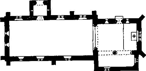
The Church, Plan
Fittings—Brass: Reset on S. wall of S. chapel, plate (16½ ins. by 4 ins.) inscribed in black-letter 'Hic iacet Thomas Faryngdon Armig' qui huc. locu. dedicari fecit qui quidem obijt in festo sci. Augustini Epi. Anno dni. Mill'o cccc.xxxiiii. cui' aie' p'piciet' deus'. Font: of Purbeck stone, with coarse reeding in two heights between rounded top and bottom mouldings, perhaps originally 12th-century but reshaped in recent times; stem and base modern.
Momuments and Floor-slabs. Monuments: In chancel, on N. wall, (1) of Anne Seymour, 1844, marble tablet by Lester of Dorchester; (2) of Rev. Thomas Seymour, 1849 and Jane Seymour, 1850, marble tablet by Lester of Dorchester. In nave, on N. wall, (3) of George Baynard, 1693, marble wall monument with carved apron, gadrooned base, scrolled cheek-pieces with flower festoons, segmental broken pediment, flame-finials and urn, apron with arms of Baynard impaling another coat; (4) of Rachel Baynard, 1667, wife of Thomas Baynard and daughter of Thomas Moore of Hattesbury, oblong inscription tablet of painted stone in egg-and-dart border, with scrolled apron with crude cherub carving, above, arms of Baynard impaling Moore, with mantling and helm, crest gone. In nave, on S. wall, (5) of Mary White, 1718, daughter of George and Elizabeth Baynard and wife of George White of Stafford, marble wall monument with carved apron, gadrooned base, scrolled cheek-pieces and Doric entablature with segmental broken pediment and arms of White impaling Baynard. Floor-slabs: In nave, near chancel steps, (1) of Radolphus Baynard [1695], Purbeck marble slab; (2) of [Thomas B]aynard, [1683], stone slab much worn.
Plate: includes silver-gilt cup and cover; cup with trumpet-shaped bowl, gadrooned in lower part and engraved with two shields-of-arms (unidentified 15 and 16), stem with knop, scroll supports and serrated foliate flange, foot moulded and enriched with oval repoussé panels; cover with enrichment similar to that of foot and with finial in form of man bearing shield and staff; probably German, 16th century. Designed to match cup is a silver-gilt flagon with oval body gadrooned above and below, with tapering neck and spout, and scrolled handle; foot similar to that of cup; engraved on body, 'The gift of George White Esq. & Mary his wife to ye Parish Church of Tinkleton in ye County of Dorset for ye Use of ye Communion Table, 1718'; probably English, c. 1718, remodelled 1900 and old hallmarks removed. Also silver-gilt paten with same inscription as flagon; also another silver-gilt paten with hallmark of 1727.
Secular
(2) Clyffe House (78189215), ½ m. N. E. of the church, was built in 1842 in late 16th-century style, the architect being Benjamin Ferrey. It is of two storeys with attics and has walls of English-bond brickwork with stone dressings ; the roofs are covered with stoneslates. To the N.E. of the main block is a slightly lower service building, planned around a courtyard. The stone windows are of many lights, mostly with transoms; those of the ground floor are capped by continuous weathered string courses ; those of the first floor have labels. The windows of the N. front and of the service building have square-headed lights ; elsewhere the heads are four-centred. The chimneystacks have groups of octagonal brick shafts with moulded cappings. Inside, the entrance hall is lined with 19th-century woodwork incorporating mid 17th-century panels with guilloche enrichment.
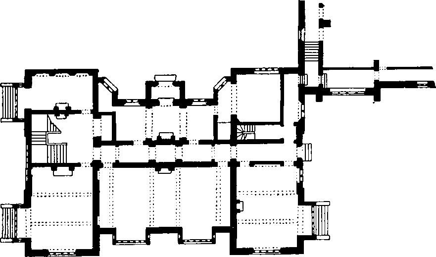
Clyffe House
(3) School (77549186), 100 yds. N.W. of the church, is of two storeys and has brick walls and tiled roofs. It is approximately contemporary with (2) and probably was also designed by Ferrey. To the N. is a master's house. The cylindrical brick chimneystacks are embellished with moulded lattice-work; the windows have chamfered stone surrounds, round heads and square labels.
(4) Tincleton Farm (76679191), house, ½ m. W. of the church, is two-storied, with walls of coursed rubble and with thatched roofs. The house dates from about the end of the 16th century and was extended S. in the 18th century. At the S. end of the original range is a stone chimney-stack with a moulded coping. Inside, there are two deep-chamfered ceiling beams, and an open fireplace with a cambered and stop-chamfered bressummer. On the first floor is a fireplace with a chamfered four-centred head; the first-floor hearth-stone rests on two moulded stone corbels.
(5) Holland's Farm (76769214), house, ½ m. N.W. of the church, is of two storeys, with brick walls and thatched roofs; it was built in the second half of the 17th century and is now two tenements. The gabled W. wall, the N. wall and the W. part of the S. wall have a continuous first-floor plat-band. The entrance, to the W. in the S. wall, has a brick porch that is integral with the rest of the wall. Inside, the ground plan comprises three rooms; that to the W. was originally the most important, having an ovolo-moulded and hollow-chamfered ceiling beam ; in the W. wall is an open fireplace. The unheated middle room has a stop-chamfered beam. The division of the house into two tenements probably dates from the early 19th century.
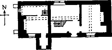
Holland's Farm
Prehistoric
Two Round Barrows lie on the high ground in the N.E. of the parish, near the centre of Clyffe Copse, just over 300 ft. above sea-level. Taylor's map of Clyffe Farm, 1770 (copy in D.C.R.O.), depicts them as small rings with trees inside and the word 'plantation' written against them; hence the bank surrounding (7) is probably a tree-ring.
(6) Bowl (78139244), near the summit of a ridge on ground that slopes S.W., lies in dense woodland and is thickly overgrown. Diam. about 44 ft., ht. about 4 ft.
(7) Bowl (78189243), 50 yds. E.S.E. of (6), lies on a S. slope in dense undergrowth; it is surrounded by a low bank, almost certainly not original. Diam. of mound, 36 ft., ht. 4½ ft.; diam. of bank from crest to crest, 61 ft.