An Inventory of the Historical Monuments in Dorset, Volume 3, Central. Originally published by Her Majesty's Stationery Office, London, 1970.
This free content was digitised by double rekeying. All rights reserved.
'Winterborne Whitechurch', in An Inventory of the Historical Monuments in Dorset, Volume 3, Central, (London, 1970) pp. 309-314. British History Online https://www.british-history.ac.uk/rchme/dorset/vol3/pp309-314 [accessed 19 April 2024]
In this section
56 WINTERBORNE WHITECHURCH (8300)
(O.S. 6 ins. ST 80 SW, ST 80 SE, SY 89 NW)
The parish lies in the valley of the Winterborne brook and has an area of 3,436 acres, entirely on Chalk. Until 1933 Milton Abbas parish included the W. part of Whitechurch village, and the parish church thus stood outside its own parish. There were originally three separate settlements in the parish, each with its own open field system; they may well be represented among the Domesday entries for the eastern group of Winterbornes in Dorset. To the N., on both sides of the brook lay Whatcombe, now Higher Whatcombe. Threequarters of a mile to the S. of Whatcombe lay La Lee, now Lower Whatcombe; both settlements have now diminished to a few houses. The S. half of the parish is Whitechurch; its houses formerly extended along the brook, but they are now grouped where the DorchesterBlandford road crosses the stream, with a small group named Lower Street outlying to the S. The principal monument is the parish church.
Ecclesiastical
(1) The Parish Church of St. Mary stands in the W. part of the village. The walls are of flint and rubble with ashlar dressings, and of banded flint and ashlar; the roofs are partly tiled and partly stone-slated. The Chancel dates from c. 1200 and there are traces of former North and South Transepts, now gone, which probably were of the same date. The Crossing was rebuilt early in the 14th century, possibly in consequence of the collapse of a former tower; the present Central Tower is of the 15th century. The South Chapel, on the site of the former S. transept, is of the mid 15th century. In 1844 the Nave was completely rebuilt and the North and South Aisles and the South Porch were added; the architect for these works was Benjamin Ferrey.
Architectural Description—The Chancel (23⅓ ft. by 15 ft.) has an early 13th-century E. window of three gradated lancet lights and, at each of the eastern corners, a restored E. buttress of one stage with a weathered capping. The N. wall has two chamfered lancets, that to the E. with a round rear-arch and that to the W. with a two-centred rear-arch; beside them are two square-set buttresses, rendered and of uncertain date. The N. wall is capped by a chamfered corbel-table with moulded and rounded corbels. Near the W. end of the N. wall, the ashlar quoin of a former re-entrant angle indicates the probable position of the E. wall of the former N. transept. The S. wall has, to the E., a lancet similar to the corresponding opening on the N. and, to the W., a lancet with a 14th-century trefoil head; the sill of the latter window was originally 1 ft. lower than at present. A little to the W. of the western lancet, a fragment of the ashlar E. wall of the former S. transept is incorporated in the S. chapel (see below). Between the two S. windows of the chancel is an original S. doorway with a chamfered two-centred head and continuous jambs. The S. wall is capped by a corbel-table similar to that on the north.
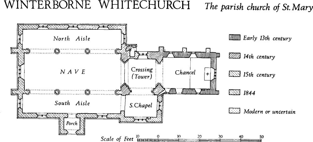
Winterborne Whitechurch, the Parish Church of St. Mary
The Crossing (14 ft. square) has, to the E., an early 14th-century chancel arch of three chamfered orders with continuous responds and chamfered plinths. The N. wall is of flint with an ashlar buttress of two stages to the E. and a projecting vice turret to the W.; the wall and buttress are probably of 14th-century origin but the turret is of the 15th century; inserted in the wall is a 15th-century window of two cinquefoil-headed lights with vertical tracery in a segmental-pointed casement-moulded head with continuous jambs. The S. and W. sides of the crossing have 14th-century arches of three chamfered orders, springing from shafted responds with moulded bases and with capitals carved with human masks and foliage; the shafting and bases are of the 14th century but the carving on the capitals (Plate 17) appears to be of the 16th century. The Central Tower rises above the crossing in two external stages. Above the flint-work of the N. wall of the crossing, which is almost equal in height with the walls of the chancel, the tower is of banded flint and ashlar with ashlar quoins. The stages are separated by a weathered string-course and at the top is a moulded string-course and a low embattled parapet with a continuous moulded coping; the parapet is probably of the 19th century. The vice turret, square at the base and octagonal above, ends in weathered stonework below the top of the lower stage; it is entered through an E. doorway with a chamfered four-centred head; an internal S. doorway with an elliptical head is now blocked. In the upper part of the lower stage, the N. wall of the tower has a reset lancet light. In the upper stage the E. and N. sides have mid 15th-century windows of two trefoil-headed lights with quatrefoils in two-centred heads, under labels with returned stops; the S. side has a narrow window with a reset 13th-century lancet head.
The South Chapel (15¾ ft. by 10¾ ft.) incorporates a fragment of the ashlar masonry of the former S. transept at the N. end of the E. wall; it bonds with the masonry of the chancel. The 15th-century walls have hollow-chamfered and ogee-moulded plinths. In the E. wall is a 15th-century window of two cinquefoil-headed lights with vertical tracery in a two-centred head, with internal and external casement mouldings. The S. wall has a similar window of three lights, with a label with head-stops; the tracery has been restored. The W. wall contains a 19th-century opening to the S. aisle.
The Nave (47¼ ft. by 18 ft.), rebuilt in 1844, has N. and S. arcades of three bays with rendered and moulded arches springing from octagonal stone piers with moulded caps, the latter being partly of plaster. In the W. wall is a window of three cinquefoil-headed lights under vertical tracery in a two-centred head. The North and South Aisles (each 9½ ft. wide) have windows of two trefoil-headed lights. The S. doorway has a four-centred moulded head with continuous jambs. The Porch has a casement-moulded two-centred archway with continuous responds.
Fittings—Bells: five; 2nd recast 1730, 3rd inscribed in Lombardic capitals 'Iesu Fili Dei Miserere', 15th century, 4th inscribed 'An Domini 1608 SH', others modern. Communion Table: In nave, of oak, with turned legs, and moulded and shouldered rails on four sides; legs shortened and stretchers missing; mid 17th century. Font: Octagonal stone bowl moulded externally and decorated with vine-scroll ornament (Plate 28); tapering octagonal stem with trefoil-headed panel on each face and moulded base; alternate sides of bowl supported on freestanding shafts, with crocketed angle standards and shields at top; N.E. shield with IHS in black-letter, S.E. shield blank, (fn. 1) S.W. shield with arms of Herring, N.W. shield with arms of Rochford; mid 15th century. Font cover, of oak, octagonal on plan, with moulded pyramidal sides and turned and enriched finial; 17th century. Glass: In N. window of crossing, three small 15th-century roundels, two with suns, one with mask, also a few other mediaeval fragments.
Monuments and Floor-slabs. Monuments: In chancel, on S. wall, (1) of Thomas Tyrwhitt, 1849, vicar, white marble tablet with pediment by Marshall of Blandford; (2) of Richard Cobbe, 1769, vicar, marble tablet. In N. aisle, reset on N. wall, (3) of Charles Blair, 1802, and others of same family, 1770–1837, marble tablet with enriched pilasters, shaped surround and gadrooned apron by Marshall of Blandford; (4) of Edmund Dowland, 1819, and Rev. James Dowland, 1824, marble tablet by Hiscock of Blandford. In S. aisle, reset on S. wall, (5) of Ann and William Clapcott, 1784 and 1790, marble tablet with pediment, arms and obelisk-shaped back-plate with cherub; (6) of John Lawrence, 1691, marble cartouche with palms and drapery; (7) of Mrs. Hussey Lawrence, 1689, cartouche similar to foregoing, with arms of Lawrence impaling Gould; (8) of John Lawrence, 1691, wall monument of painted stone with oval inscription tablet, apron with skull and leaf sprays, pendent drapery, cornice, scroll-work and urn finial. In churchyard, attached to N. wall of N. aisle, (9) of Rev. Tobias Walton, 1658, and Rev. Edward Sutton, 1726, shaped stone tablet; loose, against S. wall of S. aisle, (10) of Richard Stevens, 1783, shaped headstone with trumpets, serpent, sun and book, signed 'cut by W. Shave'; close to S. aisle, (11) of John Clapcott, 1774, table-tomb. Floor-slabs: In nave, (1) of John and Hussey Lawrence, 1691, 1689; (2) of John Lawrence, 1649; (3) of Elizabeth Lawrence, 1685.
Piscinae: In chancel, in S. wall, with trefoil-headed recess and moulded, corbelled base with quatrefoil bowl, 13th century; in S. chapel, in S. wall, with cusped two-centred head and shallow bowl cut off at wall-face, 15th century. Plate: includes silver two handled bowl (Plate 43) with hallmarks of 1653, used as communion cup, with scrolled monster-head handles and punched guilloche decoration, inscribed on rim 'J. Squibb, 1692'. Pulpit: (Plate 46) said to be from Milton Abbey, hexagonal, with four closed sides of carved and painted oak, each side comprising a canopied niche with side standards and crocketed finials flanked by trefoil-headed panels in three heights; with panelled angle posts, enriched and moulded cornice, and moulded plinth; S., S.E. and S.W. sides are 15th century but much restored; all figures, cornice, plinth and entire N.W. side modern. Sundial: In gable of S. chapel, octagonal stone dial with two metal gnomons and incised numerals, late 17th century. Weather-vane: on N.E. corner of tower parapet, with arrow and pennant, probably 18th century. Miscellanea: Reset on outside face of N. wall of N. aisle, shaped stone carved with lobed cross, probably 13th century. In S. chapel, reset above S. window, three 15th-century head corbels; in crossing, reset on N. wall, 15th-century head corbel.
(2) Chapel (Methodist) (83980025), is single-storied with brick walls, partly rendered, and with slated roofs; it was built in 1847. The windows have two-centred heads and timber surrounds.
Secular
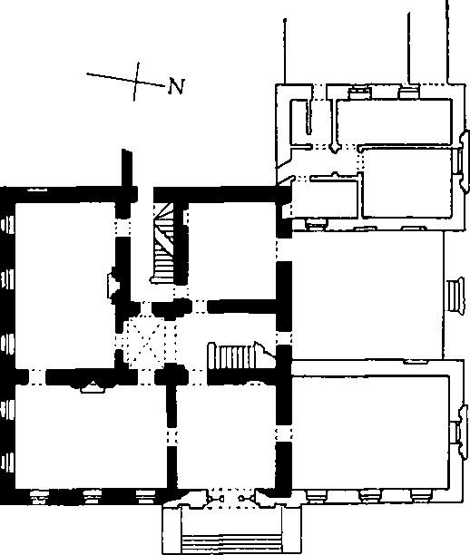
(3) Whatcombe House (837013), about ¾ m. N. of (1), is of three storeys and has rendered walls with ashlar dressings, and lead-covered roofs. The house was built in 1750 and was enlarged and altered in 1802.
The present main façade, to the E., is symmetrical and of seven bays; it is principally of 1802 but in the three southern bays it incorporates the two-storied side elevation of the 18th-century house. The central bay, a pavilion with coupled Ionic pilasters two storeys high, contains the main entrance; the lunette over the doorway is embellished with a shield-of-arms of Pleydell quartering Morton impaling Richards. The ends of the façade have rusticated quoins; above the second storey is a heavy cornice with dentils and above the third storey is a smaller cornice surmounted by a parapet with blind panels. In the second storey, at the centre, is a Palladian window; the top floor has a corresponding square-headed window of three lights. The six flanking bays are uniform, with tall sashed ground-floor windows with moulded architraves and keystones, similar but shorter first-floor windows, and others shorter still in the top storey. The S. elevation is symmetrical and of five bays with the central bay slightly wider than the others; the architectural details are as described for the E. façade. The two lower storeys presumably constituted the main front of the house of 1750 and the central ground-floor window is probably an insertion of 1802, replacing a former doorway. The central first-floor window has an eared architrave with scrolled cheek-pieces. To the W., set back, is the two-storied service wing of the 18th-century house, with brick walls and tiled roofs with stone-slate verges. The 19th-century N. front comprises two symmetrical wings flanking a deeply recessed centre bay; on the ground floor each wing has a large Palladian window and the upper storeys have single sashed windows.
Whatcombe House
Inside, the hall, at the centre of the E. range, has 19th-century door-cases with reeded architraves; the plaster ceiling is of 1750 and has rococo enrichments and a modillion cornice. The stairs (Plate 85) are of 1750 and have stone steps with moulded nosing and scroll soffits; the moulded mahogany handrail is supported on wrought-iron balusters with foliate and scroll enrichment. The drawing-room, at the S.E. corner of the house, has 18th-century decorations including a fireplace surround with garlands on the architrave and pendent rococo arabesques on the pilasters; the ceiling is enriched with similar garlands and arabesques; the doorways have moulded and enriched architraves with wreath and leaf-and-tongue decoration.
(4) West Farm (83959969), house, 600 yds. S.E. of the church, is two-storied, with walls of banded rubble and flint, banded brick and flint, and with tiled roofs. The original house comprised an E.-W. range of three rooms and a through-passage, dating probably from 1670; the range was altered and partly rebuilt in the 18th century and considerable additions were made on the S. West Farm is probably the manor house described by Hutchins (I, 198–9) as 'on the S. side of the rivulet' and almost opposite 'an ancient house and farm . . . of the Turberviles'; the latter could be East Farm, now wholly modern. The date-stone of 1670 remarked by Hutchins is now reset in the E. end wall of West Farm; it is inscribed L.S., perhaps for the Lawrence Squibb who gave a bell to the church in 1672 (Raven, 130).
The house of 1670 is represented by areas of banded rubble and flint work in the W. end wall and in the lower part of the N. front. The upper part of the N. front, the E. end wall and the exposed parts of the S. front are of banded brick and flint and are probably of the 18th century. The N. front is of three bays; at the E. end on the ground floor is a 17th-century wooden casement window of three lights with wooden surrounds. The other N. ground-floor windows are three-sided 18th-century bay windows with sashed lights and dentil cornices; between them is the entrance doorway. The first floor has modern casement windows. The S. front is largely masked by the later 18th-century extension, which has walls of banded brick and flint more regularly executed than the banded masonry of the N. front. Inside, the oak stairs from the first floor to the attics are of the early 17th century; they have square newel-posts, handrails of square cross-section with a roll-moulding attached to the upper side, and turned and moulded balusters.
To the N. of the farmhouse is an 18th-century circular Milling-house for a rotary horse-drawn mill; it was probably a cider press. The conical roof is thatched and the wall-piers are of English-bonded brickwork.
(5) The Vicarage (83640016), 30 yds. N.E. of (1), is two-storied with attics and has walls of English-bonded brickwork and tiled roofs. The house was built in 1743 and enlarged in 1781 (parish records). The S. front is of six bays, with uniform sashed windows in each storey and the doorway in one of the central bays. The eaves cornice has brick dentils. Inside, the house has been much altered but the fireplace surround, a round-headed archway and the moulded ceiling cornice of the entrance vestibule appear to be original.
(6) House (83730018), 150 yds. N.E. of (1), is two-storied with attics, and has cob walls and thatched roofs. The principal range, to the S., is of the second half of the 17th century; the range running N. from the W. end was added in the 19th century. In plan, the S. range contains three rooms, the middle one unheated, the other two with fireplaces in the gabled end walls. A 16th-century moulded ceiling beam is reset. One room contains a reset corner-cupboard with egg-and-dart enrichment.
(7) Cottage (83760019), a few paces E. of (6), is single-storied with attics and has cob walls and a thatched roof. It was built late in the 16th or early in the 17th century, probably as a single dwelling comprising two ground-floor rooms with a central chimney between them. At one time the cottage was divided into two tenements but it has again become a single dwelling. Inside, the W. room has a beam with stopped chamfers.
(8) Forge Cottage (83650008), 60 yds. S.E. of (1), is single-storied with attics and has cob walls and thatched roofs. It probably dates from the end of the 16th century but it has been much altered. The original range, only 13½ ft. wide, contained two rooms with a central chimney between them, and a throughpassage to the E. Adjacent, to the W., is an early 18th-century cottage, also of cob and thatch. To the E. of the original range is a late 18th-century two-storied cottage with brick walls and thatched roofs.
(9) La Lee Farm (83270110), house, 5/8 m. N. of (1), is two-storied with dormer-windowed attics, and has header-bonded brick walls and tiled roofs. The house was built late in the 18th century and has a symmetrical E. front of five bays with a central doorway, uniform casement windows in both storeys, a coved plaster eaves cornice, and chimneystacks on the gabled end walls. About 50 yds. E. of the house is a 19th-century Barn with brick walls and a thatched roof.
Monuments (10–14)
Except as otherwise noted, the following are 18th-century cottages of one storey with attics, with cob walls and thatched roofs.
(10) Cottage (83820175), is of the late 18th century. A 19th-century Barn to the W. has walls of banded brick and flint and a transeptal exit bay on the W. Some 50 yds. further W. is an early 19th-century cottage.
(11) Cottage (83850035), has rendered walls and a tiled roof. Until recently the W. front was approximately symmetrical, having two sashed windows with a central doorway on the ground floor, and two sashed attic windows in a mansard roof; it has now been remodelled.
(12) Cottages (83830030), range of three.
(13) Cottages (84030029), two adjoining.
(14) Cottages (84069934), range of four, at Lower Street, are two-storied. The three tenements to the S. are uniform and are each of one bay. To the N. is a larger tenement with a symmetrical E. front of three bays. A fifth tenement at the N. end was similar to those on the S. but it has recently been demolished.
Mediaeval and Later Earthworks
(15) Settlement Remains (839998), formerly part of Whitechurch, lie on either side of the Winterborne brook, S. of the present village. There is no documentary evidence that Whitechurch has ever been deserted and the remains indicate a change in the village morphology, from original settlement along the N.-S. stream to later settlement along the Dorchester-Blandford Road (cf. Milborne St. Andrew (13)). The change probably took place over a long period of time but it is likely to have been accelerated in 1752 when the road became a turnpike; even now the process is not complete since West Farm (4) and cottages (14) at Lower Street still represent the former layout. The remains consist of twenty-seven long closes, ten on the W. of the stream and seventeen on the E. They measure from 70 yds. to 190 yds. in length and from 30 yds. to 45 yds. in width and are bounded by low banks up to 15 ft. wide, and up to 3 ft. high. At the uphill ends are quarries and some poorly defined rectangular platforms measuring about 35 ft. by 45 ft. At the lower ends are uneven depressions and at least four fairly well-preserved building platforms, each measuring some 30 ft. by 50 ft.
(16) Settlement Remains (837018), formerly part of the hamlet of Whatcombe, lie W. of Whatcombe Farm at the junction of a broad tributary valley with the valley of the Winterborne brook. The settlement is probably one of the Winterbornes recorded in Domesday Book, but Eyton's identification may be no more than a guess. Eleven taxpayers were recorded in 1333 and ten householders in 1662 (Meekings, 78); the population today is approximately the same. The date of desertion of the remains is unknown. The earthworks comprise at least six rectangular closes, each about 30 yds. by 25 yds.; they are bounded by low banks, and lie between the present road and the strip fields (18) on the W. All the closes are disturbed by later quarrying but a number of possible building platforms may be identified within them. Other closes, very much disturbed, possibly lay immediately S. of Whatcombe Farm. (Destroyed, 1966.)
(17) Settlement Remains (840010), formerly part of the hamlet of La Lee, lie immediately S. of Lower Whatcombe on the E. side of the Winterborne valley. The settlement is one of the Winterbornes in Domesday Book and can be identified because it was held by Milton Abbey (Hutchins I, 199; D.B. Vol. I, f. 78a). The recorded population in 1086 was only three, but twenty-six tenants were listed in an early 14th-century custumary of the abbey (Hutchins I, 199; ibid. IV, 389). Only six householders were recorded in 1662 (Meekings, 77). The remains consist of nine long closes, up to 100 yds. long and from 20 yds. to 50 yds. wide, bounded by low banks up to 15 ft. wide; they lie along the present road. The higher E. ends of the closes are much disturbed by quarrying into the valley side but there are traces of building platforms. At the western ends there are no certain remains of house sites, but disturbed areas indicate possible sites.
(18) Cultivation Remains. The date of enclosure of the three open field systems in the parish is unknown. Strip fields of Whatcombe remain in two places: on either side of the Winterborne brook and around Higher Whatcombe. To the W. of Whatcombe Farm (around 836019) four furlong blocks of flat strips at right-angles to one another cover some 15 acres; the strips are 20 yds. to 30 yds. wide and are bounded by low banks. N.E. and S.E. of Whatcombe Farm (840020 and 842015) are the fragmentary remains of at least ten strip lynchets.
Strip fields of La Lee formerly existed in two places. In Whatcombe Park (839013) some 30 acres of narrow-rig lay over, and partially obliterated, ridge-and-furrow 5 yds. to 7 yds. wide (R.A.F. CPE/UK 1934: 3118–9). To the E. of Lower Whatcombe along the sides of a dry combe are the fragmentary remains of contour strip lynchets; air photographs show further traces to the S. and E.
The strip fields of Whitechurch remain in two places: to the S. of Lower Street (841990) there is a small area of ridge-and-furrow 7 yds. to 9 yds. wide, and to the W. of West Farm (837997) are the fragmentary remains of flat strips 30 yds. to 60 yds. wide, bounded by low banks.
Roman and Prehistoric
(19) Combs Ditch (85050217–88710000), a linear dyke, follows a sinuous course from N.W. to S.E., between 300 ft. and 400 ft. above O.D., along the broad Chalk ridge between the Winterborne brook and the R. Stour. The dyke now extends from Whatcombe Down in the N.W. to Great Coll Wood, Sturminster Marshall, in the S.E., a distance of some 2¾ miles. For most of its length it forms the parish boundary between Winterborne Whitechurch, Winterborne Kingston and Anderson on the S.W. and Charlton Marshall and Spetisbury on the N.E.
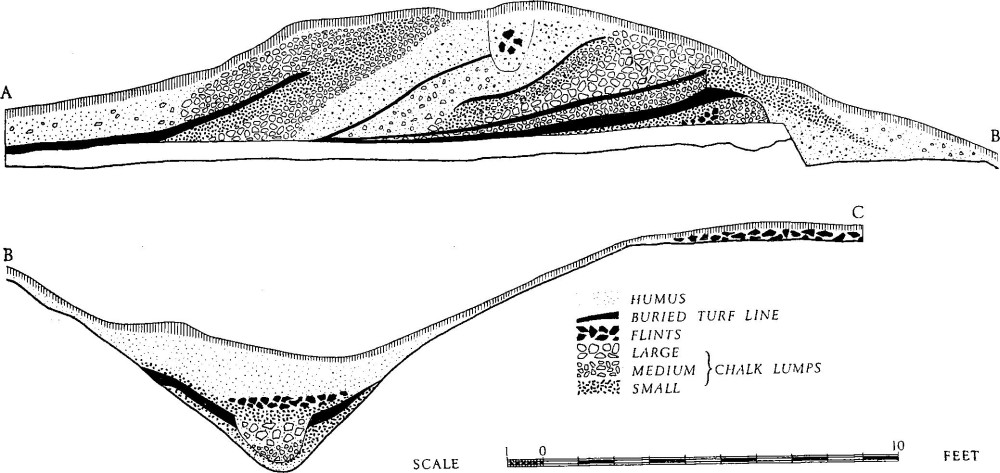
Winterborne Whitechurch. (19) Combs Ditch. Cross-section near East Down Plantation.
The dyke consists of a bank with a ditch on the N.E. side. The bank varies from 18 ft. to 28 ft. in width and from 1½ ft. to 4½ ft. in height above ground; it reaches a maximum of 7½ ft. above the present ditch-bottom E. of East Down Plantation. The ditch varies in width from 16 ft. near the S.E. end to 28 ft. at the N.W. end but it averages about 23 ft. for much of its length. A counterscarp bank by East Down Plantation, up to 22 ft. wide and 3½ ft. high above ground level, is separated from the lip of the ditch by a berm 9 ft. across. N.W. of Great Coll Wood, in Spetisbury parish, a 40 yd. length of bank, 15 ft. wide and 2 ft. high, on the outer lip of the ditch, is less certainly an original feature; no comparable remains occur elsewhere along the dyke.
The ends of the dyke are not entirely convincing and it may originally have been longer than it is now. To the N.E., on Whatcombe Down, beyond a length which has been destroyed by ploughing but which is visible on air photographs (R.A.F. CPE/UK 1934: 1137–9), the dyke bends sharply S.W. for 70 yds. and then regains its general alignment before stopping at a hedge. Beyond the hedge is cultivated land; firstly the strip fields of Whatcombe (18) and, further, the fields of Nicholson in Winterborne Clenston (6) (see p. 297); no dyke is visible in the arable but persistent cultivation for over a thousand years may well have destroyed all surface traces. Towards the S.E. end, in Great Coll Wood in Sturminster Marshall parish, the dyke is crossed by a small bank and ditch of later date, the boundary between the parishes of Sturminster Marshall, Anderson and Spetisbury. The S. continuation of this feature is sometimes mistaken for an extension of Combs Ditch; in fact the true ditch continues in a straight line for about 200 yds. before fading out in dense undergrowth. There are numerous breaks in the dyke, but none is certainly original.
The dyke is in contact with 'Celtic' fields in two areas. On Whatcombe Down, the line of the 70 yd. length of bank that runs S.W. is continued by a lynchet, and it may itself be on a lynchet although modern disturbance renders the sequence uncertain. The presence of 'Celtic' fields might account for the double bend in the dyke; there is no other obvious explanation. Further S.E., between Charlton and Muston Downs, two low banks, probably the sides of 'Celtic' fields, run up to the dyke on the N. and appear to be cut by its ditch. They probably formed part of 'Celtic' Field Group (66) (see p. 343), on Muston Down to the S. There, the fields are associated with a bank about 12 ft. across which runs along the E. side of East Down Plantation, immediately behind the bank of Combs Ditch. The dyke diverges from the main dyke where it turns E.S.E. and continues for about 40 yds., with a small ditch on the E.; it is possible that it represents a marking-out earthwork for the main dyke.
An excavation some 40 yds. E. of the S.E. corner of East Down Plantation was carried out by this Commission in 1965. A series of five turf-lines within the bank indicated successive enlargement over a long period. A single large post had stood in the top of the bank; it was a late feature if not the last in the sequence. The removal of the front of the bank to make a berm 5 ft. wide, cut 1 ft. into the Chalk bedrock between the bank and the inner edge of the ditch, was probably also a late development. The ditch itself was 17 ft. wide and 5½ ft. deep, with a V-shaped profile. Iron Age 'A' sherds in the buried ground surface beneath the banks provided a terminus post quem, but molluscan evidence suggested no cultivation before the dyke was built. Sherds of the 3rd–4th century A.D. behind the bank, and probably ante-dating its final reconstruction, were the only other evidence of date. Hence it appears that Combs Ditch is prehistoric in origin, but of a late Roman or later period in its final form. The scale of the earliest structure suggests that the dyke was originally no more than a boundary; by the end of the Roman period, however, it had become a formidable defensive earthwork. (Hutchins I, 192; H. Sumner, Local Papers (1931), 89–105; Dorset Procs. LII (1930), 59–74; 86 (1964), 112.)
'Celtic' Fields, see p. 343, Groups (64), (66).
Monuments (20–26), Round Barrows
Of the seven barrows in the parish, monument (20) forms part of a scatter that is continued on Roke Down, Bere Regis (Dorset II, p. 436); monuments (21) and (22) form part of the Deverel Down group in Milborne St. Andrew (p. 182).
Barrows shown on the Tithe Map of 1839 at 85700176 and 86120135 have now been destroyed. In 1864 William Shipp opened a barrow, possibly (25), on 'Whitechurch Down' (now East Down) close to Combs Ditch. At the centre, under a flint cairn, a deep circular cist was cut into the natural Chalk; it contained a primary cremation together with nine 'rudely chipped arrow heads' in a large 'bucket' urn. Four inhumations, one crouched and three extended, were found above the cairn and a small urn was found just below the surface on the S. side of the mound (C.T.D., Pt. 2, No. 41; Ant. J. XIII (1933), 448). A barrow at Whatcombe, possibly (26), was opened in 1898 by J. C. Mansel-Pleydell and W. Boyd Dawkins; the ditch was smoothed into a 'well-defined track by human feet circling round the burial mound' (Transactions of the Lancashire and Cheshire Antiquarian Society XVIII (1900), 122). Three barrows (86310078, 86330080 and 86340077) close together in East Down Plantation were destroyed in 1908 when East Down House was built. The northernmost, 30 ft. in diam. and 8 ft. high, was dug by J. C. Mansel-Pleydell and was found to contain a primary cremation in a large 'bucket' urn set in a central chalk-cut cist; above it lay a broken secondary globular urn; the mound appears to have contained a low internal flint wall, within which were extensive traces of fire. No details are available for the other two barrows, but a small 'bucket' urn and fragments of a globular urn may have come from them (Dorset Procs. LXXIV (1952), 104–6; Ant. J. XIII (1933), 448). Two globular urns from a barrow or barrows at South Farm (C.T.D., Pl. VI; Arch. J. CXIX (1962), 57) may have come from two barrows on the parish boundary, Winterborne Kingston (25) and (26).
(20) Barrow ? (83169754), S. of Horse Close Plantation, in the hedge forming the parish boundary with Bere Regis, lies at just over 200 ft. O.D. on top of a broad ridge and is now almost ploughed away, except where it has been protected by the hedge. Diam. about 45 ft., ht. 4 ft.
Two barrows (21 and 22) lie on the summit of Deverel Down at just over 350 ft. O.D. on a gentle N.E. slope; both have been heavily ploughed.
(21) Bowl (82329936), in the corner of a modern field; diam. about 50 ft., ht. 1 ft.
(22) Barrow ? (82349938), 30 yds. N.E. of (21), is now visible only as a slight rise; diam. about 30 ft.
(23) Bowl (85440045), just S. of Whitechurch Hill Barn, at about 360 ft. O.D. on a broad ridge sloping S., has been very heavily ploughed. Diam. about 60 ft., ht. 1 ft.
(24) Bowl (86080133), 220 yds. S.E. of Charisworth and 30 yds. W. of Combs Ditch, lies near the summit of a local rise in the Chalk, at just over 400 ft. O.D.; it has been much ploughed. An air photograph (R.A.F. CPE/UK 1934: 3122) shows the ditch as a dark ring. Diam. about 40 ft., ht. 1 ft.
(25) Bowl (86100134), 22 yds. E. of (24), is similar to it in condition. Diam. 30 ft., ht. 1 ft.
(26) Bowl (85500197), about 35 yds. from Combs Ditch on a gentle S. slope at 350 ft. O.D., lies at the head of a shallow combe on Whatcombe Down; it has been much damaged by ploughing. Diam. about 50 ft., ht. 1 ft.