An Inventory of the Historical Monuments in Dorset, Volume 3, Central. Originally published by Her Majesty's Stationery Office, London, 1970.
This free content was digitised by double rekeying. All rights reserved.
'Celtic' Field Groups', in An Inventory of the Historical Monuments in Dorset, Volume 3, Central, (London, 1970) pp. 318-346. British History Online https://www.british-history.ac.uk/rchme/dorset/vol3/pp318-346 [accessed 18 April 2024]
In this section
'Celtic' Field Groups
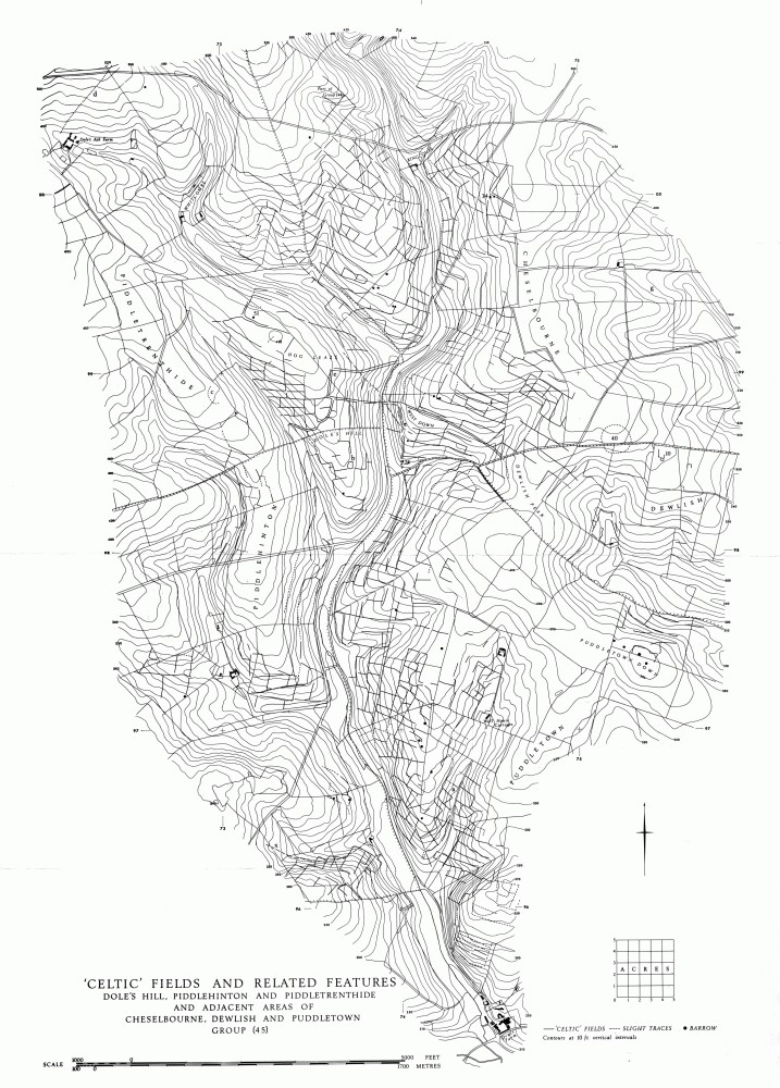
'Celtic' Fields and Related Features
Dole's Hill, Piddlehinton and Piddletrenthide and Adjacent areas of Cheselbourne, Dewlish and Puddleton Group (45)
The Field Groups in the following Inventory have been defined, for convenience of presentation, on the basis of remains which survive by chance. They are not necessarily related to ancient land-blocks and they often overlap the parish boundaries. They are therefore described outside the parish inventories and are numbered consecutively with the thirty-three 'ancient field' groups of South Dorset (Dorset II, 622–33) which they resemble; thus the first entry in the present volume is numbered (34). For convenience of reference each group is given a topographical name. Some groups are divided topographically into blocks, numbered (i), (ii) etc. Features of note within each group are identified by letters referable to groups rather than parishes. The overall arrangement, generally, is from W. to E. Some recently discovered features of Groups (35) and (36) are in West Dorset and thus constitute addenda to Dorset I.
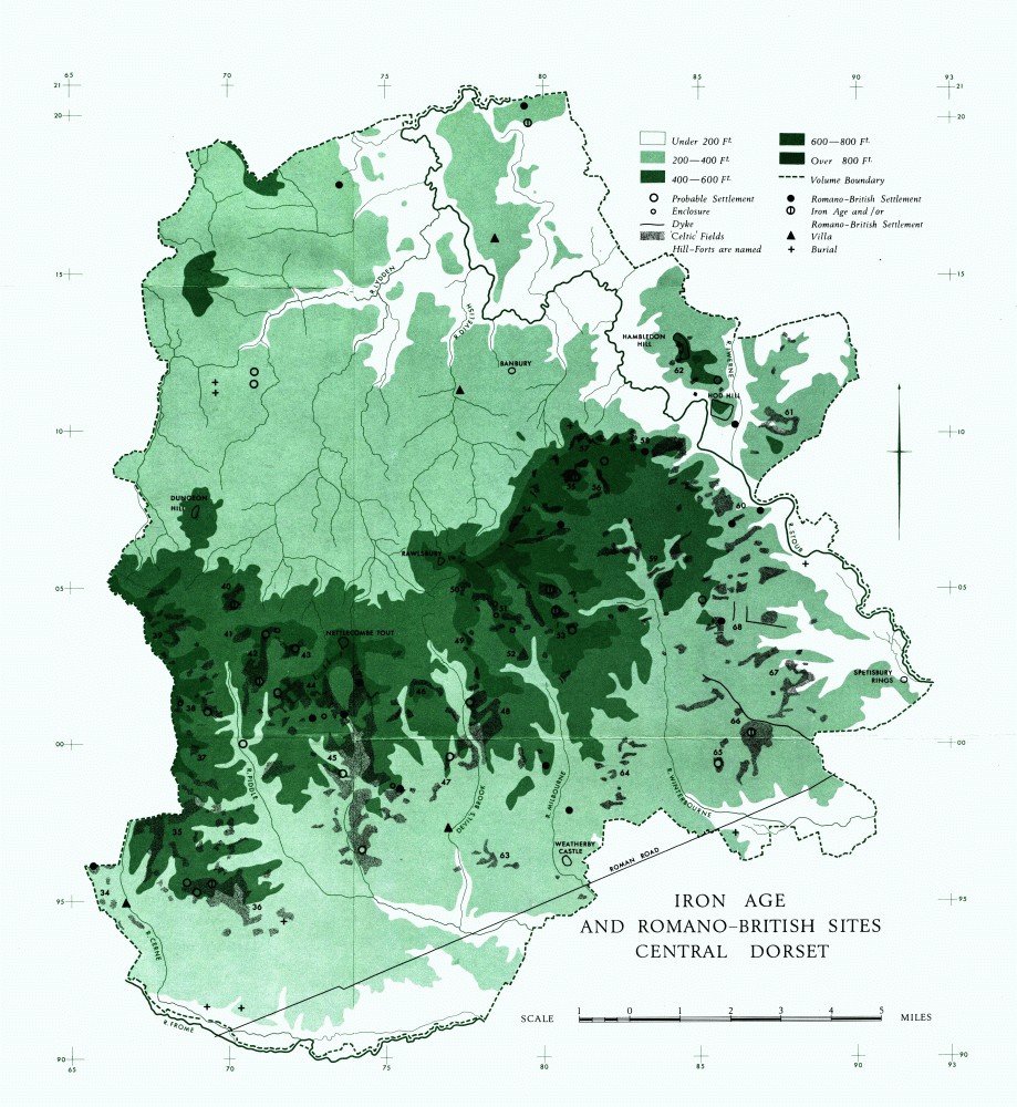
Iron Age and Romano-British Sites, Central Dorset
The distribution of the groups is shown on the general map of Iron Age and Romano-British sites (end-pocket), where also the placing of fields not otherwise illustrated will be found. Wherever possible the field groups, or parts of groups, are illustrated by drawings at a scale of 6 ins. to 1 mile; there are also detailed plans at larger scales, and reference is occasionally made to plans at 1: 2,500 in the parish inventories. Lynchets etc. are usually hachured, but when the material demands diagrammatic treatment they are drawn as plain lines.
Reference to air photographs is made in every group. Those with long reference numbers (e.g. CPE/UK 1934) are approximately vertical R.A.F. photographs, mostly taken before 1948. Many air photographs have been specially taken by Dr. J. K. S. St. Joseph, Director in Aerial Photography, Cambridge University.
Introduction
The groups vary greatly in content; their common feature is a pattern recognisable loosely as 'Celtic' fields, including different types, but they may also include settlements, tracks, dykes and so on, as well as other arrangements of earthworks which can sometimes be defined but not explained. Such features usually seem to be contemporary with the 'Celtic' field system although they may be later than particular 'Celtic' fields. Possible sites of settlement are occasionally noted, and these may be lettered on the maps, but without further evidence they should be regarded merely as suggestions.
The total area with detectable remains is 7,000 acres; a small proportion of the former total. The existence of a continuous extent of fields and associated features over some 3,000 acres of Chalk is demonstrated by Groups (44) and (45). There is little doubt that many other groups were formerly continuous and it is therefore possible that on the Chalk alone they covered 50,000 acres. Destruction has been intense, and is continuing, so that only in rare instances are unploughed earthworks to be seen. Strip cultivation probably destroyed large areas. On West Hill, Plush, for instance (Group (42)), strip lynchets lie over part of a settlement together with the 'Celtic' fields down-hill of it. There was probably a similar situation on Ibberton South Down (Group (54)) before modern ploughing completed the destruction. Evidence for broad ridge-and-furrow on the fields is relatively small, but it can be difficult to detect (e.g. Bramblecombe, Group (48, ii)). There are instances where the lack of cross-banks (e.g. Group (39, ii)) might be due to undetected secondary ploughing. One group (42) provides on Watcombe Plain, Alton Pancras, a clear and visible record of the successive use of 'downland' from the Romano-British or earlier 'Celtic' fields, through the mediaeval and possibly later strip system, to the 'narrow rig' of probable 19th-century date (Plate 86). The effect of modern levelling and ploughing is much more drastic and leads to total obliteration.
Most of the remains lie on Chalk, but they also are found on Clay-with-flints and other upland acid soils capping the Chalk, although these raised problems of chalking as well as difficulties for the ploughman. Group (55), for example, lay entirely on Clay-with-flints. Lynchets frequently have been quarried for the flints in them, notably in Groups (43) and (58). In Group (35) an exposed positive lynchet displayed sand and gravel to a depth of 6 ft. An exception is provided by the coarse gravels and sands on the ridge S. of Okeford Hill (Group (57)), edged by 'Celtic' fields which apparently stopped on its fringes. There is no sign that fields ever existed on the Tertiary Gravels, though remains occur immediately beside them in Group (63). Conversely, despite an almost total lack of surface remains, it is virtually certain that in the Iron Age and Roman period crops were grown on the band of Corallian Limestone, ½ mile to 2 miles wide, running for a dozen miles N.N.E. from Buckland Newton (N.E. of Group (40)) through Marnhull (ST 7818). The suitability of the soil and the presence of the Iron Age settlement at Marnhull (69), with its storage pits and other evidence indicating arable cultivation, suggest this; there is no evidence on the surface either of this Iron Age settlement or of nearby Roman settlement. The Roman villa, Fifehead Neville (13), is similarly invisible today. There are, however, traces of scarps which could belong to 'Celtic' long fields on Plumber Common, Lydlinch; they lie on Corallian Limestone less than 300 yds. N.W. of the villa, at 767115 (CPE/UK 1974: 2180–1). These are omitted from the distribution map out of caution, on two counts —the extreme rarity of such remains and the fact that certain boundaries on the mid 19th-century Tithe Map partly correspond with the position of the scarps.
The southern aspect provided by the dip-slope of the Chalk was fully exploited, as Group (45) clearly shows, but the fields are found facing all directions. In general, they appear to have been ploughed on slopes of up to 24°. Above this, and up to 26°, field remains occur only occasionally and then there is doubt whether they were ploughed at all (Group (62)).
The constant alignment of field axes over considerable areas is again apparent, as in some groups in Dorset II. In Group (45) an alignment is continuous across the brook N. of the group, suggesting that early boundaries were arranged geometrically from point to point irrespective of local topography. It is a curious but perhaps not significant fact that the mediaeval dam at Dewlish (8) is on a 'Celtic' alignment (Group 48)).
There is little to show the extent of land farmed from settlements, but the evidence of certain sites where settlements can be seen with attendant fields (for example, Groups (36), (42), (53), (55), (58) and (60)) suggests a bare minimum of 40 acres and probably very much more. A qualification is that settlements are often difficult to recognise (cf. Group (45), Plate 86). Occasionally there are features, such as curving scarps, to help. Compare, for instance, Groups (65) and (66). Apart from ploughing, quarrying can obscure a settlement and also can occasionally produce earthworks difficult to distinguish from open platform types of settlement (Group (51)).
Although the limits of land belonging to specific farms or settlements cannot be closely defined there are many probable boundary lines among the fields. These may be marked by a continuous line of field edges or by dykes. Such dykes sometimes appear to be later than the original pattern of fields, as in Group (44). In the E. part of the area (Groups (66) and (68)) there are signs of linear ditch divisions which may suggest comparison with the 'ranch boundaries' common in N.E. Dorset, beyond the R. Stour. The cross-dykes of Group (44), probably part of long boundary lines, and of Group (57) are close to relatively low-lying ground which may have been suitable as pasture.
Permanent pasture is otherwise indicated only by narrow bands of land alongside streams, between scarps which appear to be terminal flanking lynchets (Groups (45) and (48)). The earthworks enclosing valley bottoms, as in Group (48, i), were probably intended to contain stock but are likely to belong to a later period than the 'Celtic' fields. The slopes of lynchets can be regarded either as land wasted or as useful permanent pasture. On Green Down (Group (53)), for instance, some lynchets 20 ft. high each provide a grass strip 50 ft. wide. The large series of high lynchets S. of Meriden Down (Group (53)) is seen on Plate 87.
Tracks, often sufficiently wide and well-marked to be called roads, lead into a number of settlements, some of which are at track junctions (Groups (35) and (53)); they are generally arranged in straight lines with angular turns, but there are exceptions which curve around slopes, for example in Groups (45) and (48). These are apparently part of the original field pattern. The track leading to a settlement across Shillingstone Hill (Group (58)) curves for no apparent reason, suggesting the former existence of obstacles, such as trees, later cleared for cultivation. In at least two instances, Groups (42) and (53), the approach tracks crossed the boundaries of pre-existing fields, which continued in cultivation over a reduced area. The fact that other tracks run below lynchets which obtrude on their line could mean that the fields existed before the tracks (see plan, p. 299). There is one ditched track which varies in width as if for a purpose, as yet uncertain, but plausibly for the control of animals (Group (68)). The tracks among the unusually shaped fields of Group (37) converge in a way which suggests the proximity of settlement.
To what extent the recognisable tracks are part of an interlocking system is not certain. The ridgeways that became well known as through routes are sometimes blocked by 'Celtic' fields (as in Groups (36), (39) and (43)). Lengths of track in Groups (36) and (45), in particular, suggest that they extended beyond the areas attributed to individual settlements. In the former group the surviving stretch of road approaching Charminster (30), for instance, is ¾ mile long. The difficulties of recognising the tracks associated with the 'Celtic' fields is increased, however, by the fact that until recent years the downland was crossed by a maze of roads providing the most direct routes between a large number of points. This is illustrated on the accompanying plan, which shows how the roads noted on O.S., 1811 are on lines which partly correspond with some of the 'Celtic' tracks in Group (45). The group numbers are positioned on this plan to correspond with those on the general map of Iron Age and Romano-British sites (endpocket). (See also Plate 87.)
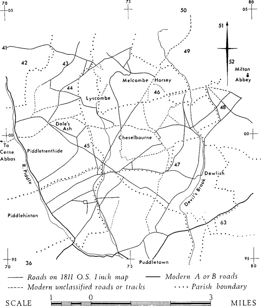
Old roads in the area N. of Puddletown
In Group (44), where one of the ancient tracks is still in use, and Group (53), tracks seem likely to have joined some of the settlements, but it is clear that they also led towards low-lying sources of water. There are no certain ponds associated with the fields, although water is held easily in areas of Clay-with-flints. In this connection O.G.S. Crawford's suggestion that 'Ringmoor' may be a corruption of 'Ring-mere' and may refer to the large circular pond on Clay-with-flints, W. of Group (55), is interesting (Archaeology in the Field, 125).
Fields are generally from ¼ acre to 1½ acres in size. When they are of square or short oval proportions their sides are seldom over 70 yds. long. There are, however, examples of long fields with lengths generally up to 130 yds. and occasionally, as in Group (66), where they appear to have been laid out on top of an earlier squarish pattern, up to 230 yds. in length. These long fields are not necessarily very precise in layout. There are other fields whose characteristic is extreme sharpness of pattern with angular corners and straight sides, again about 130 yds. long, which need not be longer than four times the width (as in Group (67)). It is tempting to think that the 'Celtic' origin of this form here removes any uncertainty that existed about the attribution of the long fields (albeit including narrow-rig) on Shorn Hill in S.E. Dorset (Dorset II, 625–7, Group (6)). Very small plots S. of the settlement at Winterborne Houghton (9), (Group (53)) and amongst the hut circles of Hod Hill (Stourpaine (11)), especially by hut 168, can be regarded as gardens. Whether the plots inset in the annex outside the Hanford Gate of Hod Hill are gardens or fields is uncertain.
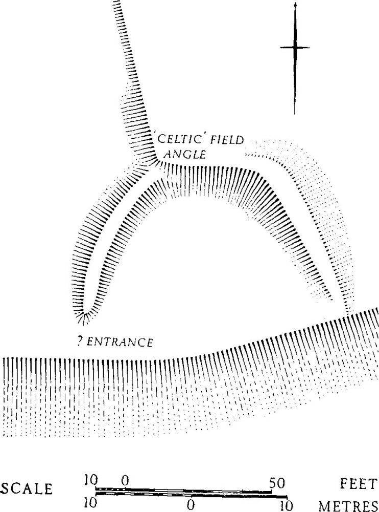
The date of the fields and of features associated with the fields cannot be stated with precision. In general it appears that fields are so arranged that sides skirt pre-existing barrows, but we cannot be sure of this in the case of the Deverel barrow (Group (64)). Dykes which are likely to be pre-Roman frequently appear to be later than 'Celtic' fields. The dating evidence for surviving settlements—and the pottery from fields—is mostly Romano-British, but this circumstance is likely to be due to the lack of excavation of settlements and to the fact that, on fields, earlier pottery, spread with manure, tends to be buried or destroyed. It seems most likely that fields existed from the Bronze Age until the end of the Roman period, but nothing can be said of later survival. There is no good information on abandonment of the higher ground. The incidence of features on top of 'Celtic' fields is by itself no indication of a date later than the system since numbers of settlements are built on fields, or extend on to them (Group (35), Nether Cerne (5), and Group (53)). In the absence of datable pottery, shape and situation can help with attribution. For instance, the 'parcels' of parallel strips in Groups (38), (64) and (67), here illustrated, are unlike anything recognised in the mediaeval period, and two of the 'parcels' are evidently overlaid by parish boundaries; failing excavation or the appearance of well-preserved earthwork forms it is impossible to guess at their purpose. Occasionally there are other patterns different from definable 'Celtic' fields, but clearly associated with them (e.g. Group (48), block (ii)). Small 'D' shaped features ((a) in Group (35) and (f) in Group (45)) are probably contemporary with the fields.
Other enclosures—and some platforms in field areas— are quite undated; nevertheless, where such an attribution seems more likely than anything later, some are shown on the Iron Age and Romano-British distribution map (end pocket).
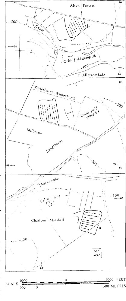
'Parcels' of strip-like features, of doubtful origin
Inventory
Group (34): Watcombe Bottom—Haydon Hill (Charminster). In the extreme W. of Charminster parish 'Celtic' fields are recognisable in a number of areas totalling about 80 acres, between 300 ft. and 520 ft. above O.D., between Watcombe Bottom (SY 656961) and Haydon Hill (673943). Clay-with-flints partially caps the Chalk in Watcombe Bottom and parts of Haydon Hill are covered in thin gravel. Most of the fields are heavily ploughed, but prominent lynchets survive on Charminster Down and in Watcombe Bottom. The fields are linked with others in Godmanstone and Stratton parishes (cf. Dorset I, Stratton (11), settlements and fields on Grimstone Down ¾ mile W. of Watcombe Bottom.) These fields are related to a probable settlement, (a).
The probable settlement, (a), of Romano-British date, lay on the N., gentler, slope of Watcombe Bottom, in arable ground. Tegulae, imbrices and pottery, with some samian and slip-coated New Forest ware, were scattered for at least 50 yds. about 65759608 (Dorset Procs., 76 (1956), 75). A lynchet ran N.-S. through this area, suggesting that the settlement lay partly over 'Celtic' fields. W. of this, faint traces of probably ditched features appear on air photographs (CPE/UK 2475: 3187–8). A double-lynchet track approached the settlement area from the S. Two 'Celtic' fields across the valley floor E. of this were 22 yds. and 26 yds. wide and up to 150 yds. long. Lynchets reached 11 ft. high at the foot of the steep valley side S. of these.
On the E. shoulder and sides of Haydon Hill, 1 mile S.S.E., 'Celtic' field fragments survive in a thin line extending for 700 yds. S.E. from 668946, by Walls Coppice, 250 yds. S. of the Roman villa, Charminster (29).
Air photographs: CPE/UK 2475: 3185–9 and 4124–5.
Group (35): Well Bottom Down (Piddletrenthide and adjacent areas in Charminster, Piddlehinton and Nether Cerne (Dorset I). Map on p. 323). 'Celtic' fields are traceable over 800 acres within the area Bushy Eweleaze, Forston (SY 673957) and Cowdon Hill (670974), both in Charminster parish; College Down (687992) in Piddletrenthide parish; and Coombe Bottom (705970) in Piddlehinton parish. Most of these remains are very slight, but 190 acres of fields, though very incomplete and almost all affected by later ploughing, were surveyed on Well Bottom Down, Piddletrenthide, an adjacent area to the S.W. in Charminster, and another to the W., in Nether Cerne, containing a Romano-British settlement (Nether Cerne (5), at SY 682985). There is a small D-shaped enclosure, (a), 300 yds. N. of this, at 68179875. To the S., the group was contiguous with 'Celtic' field Group (36), about 700967. The fields lie between 350 ft. and 650 ft. O.D. on the N.-S. Chalk ridge between rivers Cerne and Piddle, the spurs E. and W. of it and the re-entrants separating them. Gravel, clay and sand lie over the Chalk in the area of 'Celtic' fields N. and W. of settlement Nether Cerne (5). (fn. 1) There are many small quarries in this area and 1,300 yds. S., in Charminster, about 684975. Some quarries are cut into and along lynchet faces.
Group (35): Enclosure (a)
Settlement Nether Cerne (5), showing occupation remains in a disturbed area of some 3 acres in and S.W. of the enclosure described under this number in Dorset I, lies at least in part on older 'Celtic' fields. The enclosure is a field with a ditch dug along two of its sides, 50 yds. and 40 yds. long; the N.W. side is a lynchet and any S.W. side has been destroyed. 'New Forest' beaker fragments were found amongst sherds in rabbit scrapes here. Samian ware was found amongst other pottery 100 yds. S.W. of it (Dorset Procs., 74 (1952), 91: (ii) to (iv)). Enclosure (a) here shown, has a slightly sloping interior of 75 ft. by 50 ft., but its bank is much spread. A 'Celtic' field lynchet, itself much disturbed by later ploughing, appears to spring from the enclosure bank on the N., suggesting a contemporary relationship. The lynchet below the enclosure, 7 ft. high, has been disturbed. Over a mile S.S.E., two destroyed earthworks lie in close but indeterminable relationship to 'Celtic' fields. These are the rectangular enclosure Piddlehinton (24) and, 1,000 yds. N.W. of it, in the N.W. corner of the same parish, at 68959705, an ovoid feature, (b), visible only on air photographs (CPE/UK 1974: 1370 and Cambridge University Collection, oblique AND 8). This lay on almost flat ground rising gently W. above 400 ft. O.D. About 160 ft. long and 120 ft. broad, aligned N.-S., the feature is defined by a narrow ditch (or two concentric ditches).
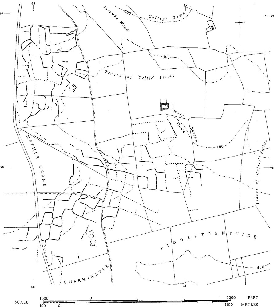
Group (35): Well Bottom Down
The fields as a whole are on gentle slopes, facing all directions, lynchets being up to 8 ft. high. An exposed lynchet section S.W. of Nether Cerne (5) showed the positive element, almost 6 ft. high, to consist entirely of sandy, clayey ploughsoil with abundant flints. The few surviving complete fields suggest proportions from square to 2:1 and sizes from ⅓ acre to 1 acre. The apparent long fields W. of (a) were produced by the overploughing of cross-lynchets N. to S. leaving traces of broad-rig earlier than the present enclosure pattern. In the area S.S.W. of this there was abundant narrow-rig.
Air photographs: CPE/UK 1974: 1369–72; 3370–2; Cambridge University Collections, obliques, AND 9 and ANF 51.
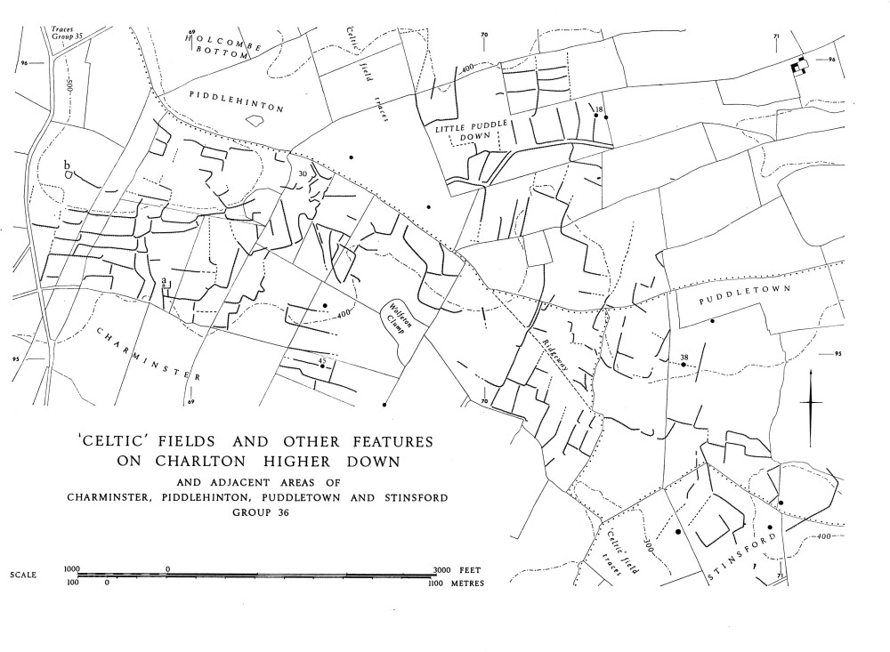
Group (36): Charlton Higher Down (with adjacent areas in Charminster, Piddlehinton, Puddletown and Stinsford, comprising 'Celtic' fields, settlement and other remains. See map opposite). 'Celtic' fields covered at least 600 acres on Charlton Higher Down, Charminster (E. from SY 684954), Little Piddle Down, Piddlehinton (to 703960), Waterston Ridge, Puddletown (to 720943) and parts of Stinsford S. of this (to 710940). The remains were prominent on Charlton Higher Down, where parts towards the W. were the only portions not in modern arable, but incomplete even there owing to former destruction by ploughing. Elsewhere the pattern is much broken. Very faint traces show that the group was virtually continuous with Group (35) on the N. There are isolated fragments E. and S. of the main block: on Little Piddle Hill (711958) and N. of Seager's Barn, Charminster (698938).
A settlement, Charminster (30), on Charlton Higher Down (see plan, p. 73), is at the junction of local roads associated with the 'Celtic' fields. There are two other possible settlements, (a) and (b), W. of this, also on Charlton Higher Down.
The fields lie mostly on gentle slopes between about 300 ft. and 550 ft. O.D. on and about a ridge E. from the N.-S. ridge between the rivers Cerne and Piddle. They are generally on Chalk, but at least 20 acres are on sandy loam of the Reading Beds on the summit of Charlton Higher Down (690956). Sandy clay also occurs in patches E. of this. Some podsolisation was visible near Settlement (30) and water was held in a modern pit there. Purple 'heathstone' was scattered in the settlement area.
Settlement (30) existed between the 1st century, at latest, and the 4th century A.D. It is approached for ¾ mile from the E. by a road, now incomplete and all of it under the plough, which shows as a double-lynchet track with surface 7 yds. wide on the E. of Little Puddle Down, and as a hollow between banks of chalk and clay where the ground rises W. from the Down. 'Celtic' fields were arranged on either side of it. The road forks N.W. and S., just N.E. of the settlement, the junction forming a small open space about 20 ft. across. It is possible that a road also continued W. from the settlement.
Possible settlement (a), 68919521, is suggested by a scarped and banked rectangular enclosure, 38 yds. by 14 yds. on the edge of a block of fields with a shallow gully immediately W. A circular depression about 27 ft. across, almost surrounded by a slight bank, lies N. of it. A gap in the bank facing S.W. is, however, uncharacteristic of hut-circles. There is a curving bank, unusual amongst ordinary fields, 100 yds. N.W. of the circle.
Possible settlement (b) depends chiefly on air-photographic signs of a possibly banked enclosure, roughly 100 ft. square, but with the S. side rounded, at 68599562 (CPE/UK 2475: 3189–90) near the summit at the W. of Charlton Higher Down, above 500 ft. The ground S. of this is uneven and there is a break in the regular pattern of fields.
The remains of a continuous belt of fields have survived for 2 miles from W. to E. At 702953 an almost straight line of lynchets running for 600 yds. S. from Peak Coppice suggests a boundary. Staggered angles are common, especially S.E. of Charlton Higher Down. Destruction has left very few complete individual fields. There are indications of proportions of about 2:1, lengths from 83 yds. to 100 yds., sides from 30 yds. to 50 yds., and sizes from ½ acre to under 1 acre. Lynchets up to 6 ft. high occur over the whole area and are up to 10 ft. high on Charlton Higher Down. Relationships with other earthworks are few. Barrows appear to have been respected. Two, Charminster (45) and Piddlehinton (18), clearly lay at field angles. Puddletown (38), a probable barrow, is also at a field angle. All parish boundaries cut across 'Celtic' fields as does the ridgeway connecting Puddletown with the Dorchester-Sherborne ridgeroad; the line of this ridgeway is visible running S.E. from 700952.
Air photographs: CPE/UK 2475: 3185–93; 4115–6. Cambridge University Collections, oblique, AY 7 and 8. Other oblique photographs of settlement Charminster (30) taken by W/Cdr. H. J. Penrose.
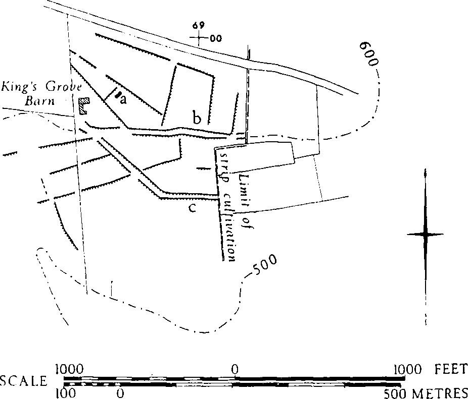
Group (37): King's Grove (Piddletrenthide). 'Celtic' fields of unusual form with one very well-preserved double-lynchet track met by another, less well-preserved, lie within 24 acres immediately W. of the open fields of Middle Tithing, Piddletrenthide (40), and S. of the present ridge road to Cerne Abbas, about SY 689999. The ground slopes gently S. from the ridgetop to a wet combe bottom. Patches of clay apparently lie over the Chalk bed-rock.
'Celtic' Fields and Other Features on Charlton Higher Down and Adjacent Areas of Charminster, Piddlehinton, Puddletown and Stinsford Group 36
The prominent track (b), 10 ft. to 16 ft. wide between lynchets about 4 ft. high, runs W. across the middle of the area to a point just S. of King's Grove Barn, where it is met by the second track (c). Fields N. of this junction have tapering ends. One, a pentagon, has in the N.W. angle an oval mound (a), (68849990). This is 40 ft. long S.W.-N.E. and 23 ft. wide, with a flat top 8 ft. by 6 ft. indented by a shallow hole, and is about 4½ ft. high above the surface of the field whose N.W. bank skirts it. It is unlike any usual barrow or 'pillow-mound'. There is no sign of ploughing immediately beside it. Fields here and to E. are bounded by banks about 15 ft. across and up to 1 ft. high, in places deepened by cultivation into scarps up to 4 ft. high. The largest field is nearly 2 acres and the longest is 160 yds. by 40 yds. (Now totally destroyed by ploughing.)
Air photographs: F.21 540/RAF/1775: 0219.
Group (38): Cow Leaze—Kiddle's Bottom (Alton Pancras and Piddletrenthide). Five small blocks of fragmentary and disturbed 'Celtic' fields, numbered (i)–(v), once probably continuous, occur in the N.W. of Piddletrenthide and in the S.W. of Alton Pancras parishes; blocks (ii)–(iv) are illustrated. The actual remains total about 110 acres, between 400 ft and 700 ft. O.D., mostly on the sides of spurs E. from the N.-S. Chalk ridge and in the valley bottoms between. There is one possible settlement, (a) in block (ii), and one certain and two probable instances of fields being overlain by enclosures of uncertain date, in (iii) and (iv). Some of the fragmentary lynchets were very high. A rare example occurs, (b) in block (iii), of close-set, parallel divisions, possibly ditched, in an enclosed area of about 5 acres; they are seen only on air photographs. The remains are generally beyond the limits of the open fields but some, in (v), are overlain by strip lynchets. Extensive destruction is apparent even in areas of old pasture. Broad ridge-and-furrow was visible in the area of block (iii).
Group (38): Cow Leaze—Kiddle's Bottom: blocks (ii)–(iv)
Block (i), Kiddle's Bottom, SY 687005: traces exist over 4 acres towards the head of the valley.
Block (ii), Higher Down, SY 684013: 25 acres in all, on both sides and bottom of re-entrant S. of spur. Well-marked, though partly spread, lynchets lie parallel 28 yds. to 40 yds. apart up and down the S. slope; cross divisions are less clear. Lynchets are generally under 1 ft. high, exceptionally 4 ft. A field on the N. slope is trapezoidal, ⅓ acre in area.
On the spur top, at 68430133, is an almost destroyed nearcircular earthwork, (a), sometimes shown on maps as 'tumulus' or 'hut circle'. A spread flint-packed bank 18 ft. across, with external ditch 12 ft. across, up to 3 ft. below the bank, now encloses rather more than a semicircle 79 ft. by 66 ft. It is open, or broken, at S.E. where a slight curving scarp crosses the enclosure. There is a shallow circular depression 15 ft. across, W. of centre. Very faint traces of fields around suggest that the earthwork was avoided as if contemporary or earlier.
N. of the spur are very faint traces of cross-valley scarps, 30 yds. to 35 yds. apart; one contour scarp on the N. slope is 10 ft. high and sharply-defined as if built up or reused in an area of destruction.
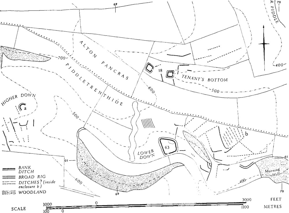
Block (iii), Lower Down, from ST 691011 (formerly Serpentine Plantation) to 699010 (Morning Well Plantation): about 33 acres N. of the valley bottom and on Tenant's Hill show remains of very fragmentary 'Celtic' fields on a slope rising from gentle to an inclination of 18°. Lynchets S. of Sole Copse, about 696009, were 8 ft. to 14 ft. high. On the southern shoulder of Tenant's Hill, 697011, there is an enclosed area, (b), defined by scarps, cut by the Piddletrenthide/Alton Pancras parish boundary. It is some 170 yds. by 130 yds. with two sides slightly curved. Inside it, air photographs show at least 6 roughly parallel strips defined by flanking dark lines, presumably ditches or furrows, up to 160 yds. long (see p. 321). The enclosure is central to 'Celtic' fields which radiate from it, producing a triangular field on S.E. (CPE/UK 1974: 2371–2).
Undated enclosure Piddletrenthide (63) probably lies on 'Celtic' fields. A lynchet runs down to its N.E. angle and disappears. A platform inside its N. side and a scarp inside its S. side may derive in part from lynchets.
An isolated and disturbed section of double-lynchet track, with scarps 4 ft. high above and below and with a hollowed tread 4 yds. across, runs from the N.W. corner of Morning Well Plantation (69850098), S.W. for 200 ft. then N.W. for 150 ft.; 'Celtic' fields probably are linked with it on the S. Obscured by scrub in the plantation were strip lynchets or 'Celtic' fields modified.
Destruction is generally marked by incompleteness, but at 69130123, E. of the old Serpentine Plantation, were ten low plough ridges, 7 yds. wide, down a slope increasing to 17°, where 'Celtic' fields could not be detected.
Block (iv). In Tenant's Bottom, ST 692014 to 698017, 20 acres of very fragmentary remains are just visible on both sides of the valley. Undated enclosure (18a), on the W., is built partly on a lynchet, the inner scarp of its N. side being 5 ft. high compared with the 1 ft. of its S. bank. A lynchet approaches the S.E. angle of enclosure (18b) from S.S.E. and is probably overlain by it.
Block (v). On Rake Hill, Rake Bottom and Cowleaze, ST 691020 to 696020, about 25 acres of 'Celtic' fields are almost completely incorporated in a pattern of strip fields (cf. Alton Pancras (15)).
Air photographs: CPE/UK 1974: 2371–3; 1975: 1042–4; F. 21 540/RAF/1775: 0222.
Group (39): Barnes's Lane (Alton Pancras, Buckland Newton and Cerne Abbas (Dorset I)). The group consists of some 180 acres of much broken 'Celtic' field remains in the N.W. of Alton Pancras and S.W. of Buckland Newton parishes, extending from about ST 680027, S. of Holcombe Wood, to Ridge Hill, 680050. A few traces continue W. into Nether Cerne. There are two possible settlements, (a) and (b).
The fields lie between 575 ft. and 800 ft. O.D. on the E. side of the N.–S. Chalk ridge and on the spurs and in the bottoms E. of it. Even the best-preserved area, about 60 acres, S. of Barnes's Lane (see plan), had been considerably disturbed by chalk pits, by strip lynchets and by ploughing of uncertain date. Lynchets here were up to 6 ft. high and fields sloped up to 24°. Elsewhere, the remains were much broken, though individual lynchets were occasionally prominent. Strip lynchets impinge on 'Celtic' fields on the lower slopes of Ridge Hill, 681049.
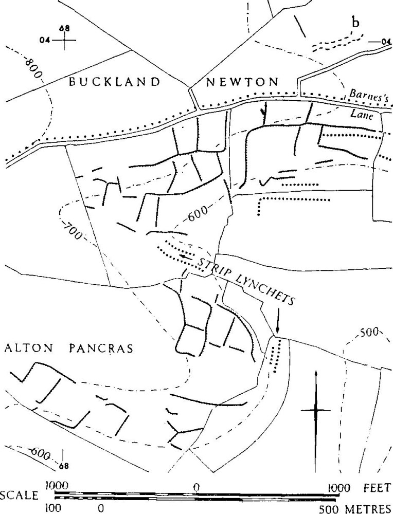
At the extreme S.W., 200 yds. S. of Holcombe Wood, at 67700275, inside Cerne Abbas parish, is a hitherto unrecorded enclosure, (a), just apparent on air photographs (CPE/UK 1975: 1044–5). It lies in arable land on the E. brow of the ridge at 800 ft. O.D., its flattened bank, about 20 ft. across, enclosing a rough semicircle about 70 ft. by 50 ft. (possibly comparable with (a) in Group (38), 1 mile S.S.E.). At least one lynchet appears to join it on the E. In Buckland Newton parish, at 68580403, in arable land N. of Ford Down Lane, traces of irregular close-set terraces (b), up to 130 yds. long, may mark the site of a settlement. Romano-British tiles and coarse pottery have been found scattered on the 'Celtic' fields just S. of Barnes's Lane where, at 68370376, a schist hone was also found (Dorset Procs., 76 (1954), 76, 98–9.)
Lynchets formerly crossed the line of Barnes's Lane and there is no sign of a contemporary route to correspond with the 'Great Ridgeway' (cf. Timperley and Brill, Ancient Trackways of Wessex (1965), 20).
Air photographs: CPE/UK 1974:4370–2; 1975:1043–5; 2431: 3354–7).
Group (40): Knoll (Buckland Newton). About 100 acres of very disturbed 'Celtic' fields are detectable between 500 ft. and 650 ft. O.D. facing all directions on the prominent small hill, Knoll, of Middle and Lower Chalk, projecting beyond the main Chalk escarpment (ST 69800420–70300505). There is a probable settlement, (a).
The fields are bounded by Landscomb, Castle and Bookham Lanes but formerly continued on all sides, though not necessarily on to the Upper Greensand N. and E. of the area. The probable settlement, (a), at 70130442 just S.E. of the hill-top, covered about 3 acres with a track entering it from N.W. Platforms, on a 9° slope, have been flattened by ploughing, but the faint remains suggest similarity to Piddletrenthide (43). A few sherds of Romano-British pottery were found on the surface.
No certainly complete field survives, but some lynchets left unploughed are up to 8 ft. high on a natural slope of about 10°.
Air photographs: CPE/UK 2431: 3352–3.
Group (41): Barcombe (Alton Pancras; Plate 88). Modified 'Celtic' fields cover 15 acres of the S.W. slopes of Church Hill (ST 70200330–70690337) N.E. of Barcombe Farm on Chalk between 500 ft. and 600 ft. O.D. An early pattern of squarish fields has been overlaid by long fields, in one case measuring 180 yds. by 30 yds. Other ploughing, probably mediaeval, has further altered the plan.
Mediaeval alteration is indicated by the fact that, uphill, some fields end in an arc typical of strip lynchets and that, downhill, lynchets continue towards the valley bottom, where, although almost destroyed, there are remains of the strip fields of Barcombe (Alton Pancras (15)). Field slopes are 12° to 17½°. Downhill lynchets up to 18 ft. high have partly determined the sinuous line of the present hedge along the N. side of the bottom.
Immediately N.E. is a continuous lynchet line, up to 10 ft. high at the E., forming the edge of other cultivation which has probably destroyed former 'Celtic' field remains continuing E. towards Group (42).
Air photographs: CPE/UK 1975: 1041–2.
Group (41): Barcombe
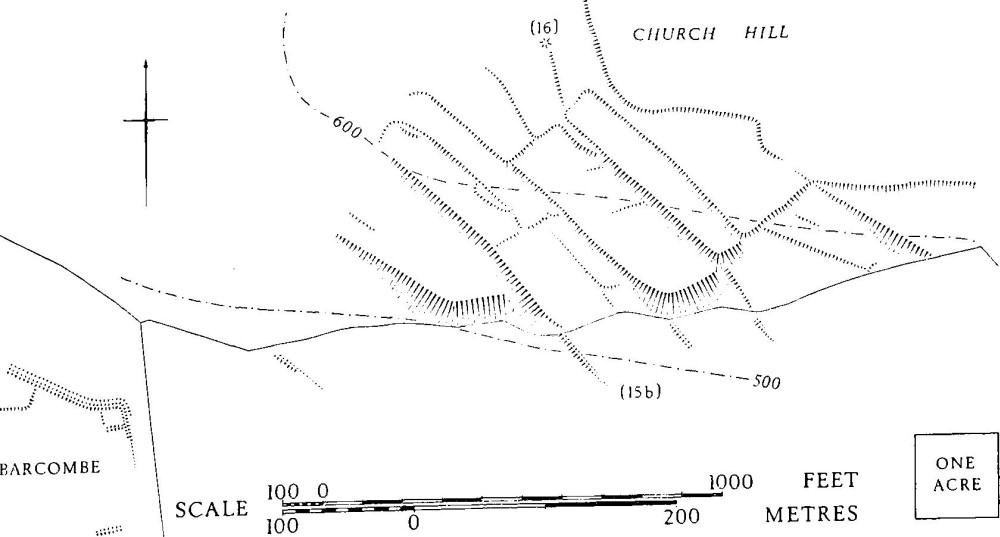
Group (42): Watcombe Plain—West Hill (Alton Pancras and Piddletrenthide. Plan, p. 328; Plate 86). 'Celtic' fields are traceable over about 190 acres on the spur of Lower to Upper Chalk that runs for 2 miles N.N.E. from East Hill, Piddletrenthide, to Church Hill, Alton Pancras, rising from 500 ft. to about 760 ft. above O.D., ST 70450085–705023–715035–713026. The pattern is fragmentary, some prominent lynchets being allowed to survive out of convenience, but it is continuous from West Hill to Church Hill. The best preserved 'Celtic' fields and a double-lynchet track are on West Hill, W. of the contemporary settlement Piddletrenthide (43), (see plan, p. 220). To the E., strip lynchets lie over 'Celtic' lynchets. On Watcombe Plain there is particularly clear evidence of a sequence comprising narrowrig overlying strip lynchets, overlying 'Celtic' fields. Old quarry pits have been dug into some of the larger lynchets. Stretches of a reused track, contemporary with the 'Celtic' fields, lead to the site of a possible settlement in the area of (a), on Church Hill (712035). There are traces of low banks and scarps on the ridge between this site and enclosure Alton Pancras (19), but no visible relationship with that enclosure.
Group (42): Watcombe Plain—West Hill
Lynchets are up to 8 ft. high on West Hill. Some fields are marked by banks running against the slope, but in places the appearance of banks is produced by secondary ploughing behind a lynchet head; this also makes it difficult to be sure of original field measurements. Changes of arrangement contemporary with the settlement are indicated by the fact that the doublelynchet track, in places 10 ft. wide with an uphill lynchet up to 5 ft. high, crosses the first-phase lynchet of a field, immediately S. of the settlement, in which continued ploughing has built up a new lynchet against the track edge. On Watcombe Plain lynchets are up to 15 ft. high. The bank (n), 6 ft. across and 2 ft. high, with a ditch partly visible on the S. side, is at the southern limit of narrow-rig and strip lynchets. It lies on a 'Celtic' field boundary. The track W. of this is 10 ft. wide, edged by a bank 7 ft. wide and 1 ft. high on the W. and by scarp increasing from 1½ ft. to 6 ft. high on the E. It is almost destroyed by cultivation in places, but it assumes double-lynchet form, with 'Celtic' fields clearly associated, N. of Watcombe Plain. The bank curving eastwards at (a) on Church Hill, continuing the line of the track, is 14 ft. wide and up to 2½ ft. high. The area is much disturbed. The factors suggesting settlement hereabouts include the curved bank, the track leading towards it, the suitability of the situation, and its spacing relative to Piddletrenthide (43) and the probable settlement on Ball Hill (Group (43), area (a)).
Air photographs: CPE/UK 1975: 1040–2; Cambridge University Collections, verticals, K. 17, E. 152, 158–9 and obliques, LR 38–40, 42; AND 14–16, ANF 46–9; AAU 11–13.
Group (43): Ball Hill (Piddletrenthide. Plan, p. 329; Plate 86). 'Celtic' fields, much altered, lie on the summit and slopes of the spur falling S. from Ball Hill, from 800 ft. to 600 ft. O.D., between about ST 725033 at N.E. and 716027 at S.W. Remains, still clear over 50 acres, formerly continued in all directions. To the W., on the S. slopes of Church Hill, they probably joined those of Group (9). There is a probable settlement (a) on the S.E. shoulder of Ball Hill, about 72050305 flanked by a bank (b), with apparent ditch N. of it possibly reused as a track (profile X–Y). Some 250 yds. S.W. of (a), at 71890285, near the summit of the spur, in an area of still quite prominent but considerably disturbed 'Celtic' fields (not shown on the plan), is an almost rectangular platform, about 66 ft. by 42 ft., bounded by low lynchets. The bedrock is Lower and Middle Chalk, with a dense spread of flint on the latter. There has been considerable digging for flints, some of the digging following the line of the lynchets; the circular sinkings N. and N.E. of (a), on slopes of 8° and 20°, are probably due to this. Strip lynchets, mostly destroyed by later cultivation, have intruded into 'Celtic' field remains near the foot of the hill. Immediately W. of Kithill Plantation only the W. ends survive, with risers up to 6 ft. high.
'Celtic' Fields and Probable Settlement, Ball Hill Part of Group (43). Piddletrenthide
The area of probable settlement (a) is on a gentle sheltered slope facing S.E. It is approached from below, in the S., by a prominent terrace or double-lynchet track, first traceable near the square modern pond. The main section, which may have been ploughed, has a 'tread' about 18 ft. wide between downhill scarp up to 5½ ft. high and uphill scarp 7 ft. high. This latter almost disappears after 70 yds., but a track, where best preserved 9 ft. across between uphill scarp 2 ft. high and downhill scarp 3½ ft. high, bends due N. and then curves westward. It is flanked by a disturbed area, probably with platforms, on the W. side. The curved line of lynchets bordering area (a) on the W. itself suggests former settlement. The double-lynchet feature approaching the same area from the S.W. probably had 'Celtic' fields bounded by the lynchet, 4½ ft. high, on its S.E. side, but the scarp on the N.W. side, 2½ ft. high, could be the product of secondary ploughing. This is probably the explanation of the double-lynchet line that lies at right angles S.E. from the narrower end of this feature.
Bank (b) is 20 ft. across and 2 ft. high above a flat-bottomed hollow, on its N. side, as wide as the bank. It prolongs the alignment of a continuous series of lynchets, not determined by the contours, which runs for at least ¼ mile and suggests a former boundary. The hollow has been blocked by cultivation scarps or banks. 'Celtic' fields based on this line are crossed by the present ridgeway, seen in the N.E. corner of the plan on p. 329.
The 'Celtic' fields are generally bounded by lynchets, exceptionally up to 11 ft. high above the steep S.E. slope. There are, however, some field banks, probably 'Celtic', N. of (b), which are about 13 ft. across and 1 ft. high, packed with flints. Field sizes cannot be assessed with safety because of the destruction of some sides, but they appear to range between 30 yds. to 40 yds. by 60 yds. to 70 yds. Field slopes are up to 18°.
Air photographs: CPE/UK 1974: 4367–8; 1975: 1038–40; Cambridge University Collections, vertical, K.17, E.162–3; obliques, LR 37–42.
Note on Groups (44) and (45). These groups are very large, covering a total of almost 3,000 acres. They are in fact a single unit, but are divided here for ease of presentation. The road from Piddletrenthide to Cheselbourne, mediaeval if not earlier, is taken quite arbitrarily as the boundary between the groups; indeed, in several places it crosses 'Celtic' fields which prove the continuity of the groups.
Group (44): Plush Hill and Lyscombe (Piddletrenthide, Cheselbourne and Melcombe Horsey. Map opposite). 'Celtic' fields are detectable within about 800 acres from the area of Plush Hill on the W. (ST 712006– 717021) to Bowden's Hill, Melcombe Horsey at N.E. (741024) and the Kingcombe area of Cheselbourne at S.E. (747004). They lie on Lower and Middle Chalk between 360 ft. and 800 ft. O.D. The pattern is fragmentary, but was probably continuous except on the high ground around the N. half of Lyscombe Bottom, where the main surviving earthworks are an incomplete hill-fort on Nettlecombe Tout and a number of dykes. Other dykes, later than some of the 'Celtic' fields among which they lie, are S. of this. There are two settlements, Piddletrenthide (44) on Plush Hill, probably associated with 'Celtic' fields, and Melcombe Horsey (11), closely associated with a well-preserved small area of fields. Two other settlements are indicated by occupational debris (Piddletrenthide (41) and Cheselbourne (21)). There are at least four sections of double-lynchet track, three connected with settlement. A large angular enclosure, Piddletrenthide (65), is linked to the 'Celtic' field complex and may be contemporary, but the small enclosure Piddletrenthide (64), totally destroyed without any occupational material being reported, was probably later. Only the more easterly part of the group is illustrated.
In the W. of the group the 'Celtic' fields on Plush Hill, though now partly pasture, have all been reploughed. Narrow rig lies on strip lynchets W. of settlement Piddletrenthide (44), where there is no trace of 'Celtic' fields. Elsewhere around the settlement some low 'Celtic' scarps have been left, occasionally emphasised by lines of scrub growing on them. At N.W. of the area, where the old road from Lyscombe to Plush cuts across 'Celtic' fields on steeper ground, the scarps are prominent, but there are no certainly complete fields visible here or in the Thorncombe area further E. Numerous roughly circular sinkings, called 'pit dwellings' on some old maps, are chalk pits. Two mounds, probably barrows, Piddletrenthide (55) and (56), apparently lie at 'Celtic' field angles.
In the E. half of the group two sections of a double-lynchet trackway, now destroyed, on Pond Eweleaze, E. of Thorncombe, ran from 72600087 S.E. to 73050057. The northern section skirted Romano-British occupation remains at 72590092, and a gap in the lines of track corresponded with the position of further occupation remains, formerly including earthworks, at about 727008, Piddletrenthide (41), below enclosure (65), (F.21 540/ RAF/1775: 0221–2). Further E. 'Celtic' fields are still detectable over 200 acres on the S.W. and S.E. sides of Lyscombe Bottom, the ground above, and in the re-entrant valley below Hog Hill at the S.E. of the area (742013). They formerly existed on Bowden's Hill E. and N. of settlement Melcombe Horsey (11) and they possibly extended N. to Nettlecombe Tout, but there is no trace on the N.W. side of Lyscombe Hill, between dykes Piddletrenthide (45) and (47). There are outlying traces on Nordon Hill (753028).
There are numerous earthworks, many related to 'Celtic' fields, on the high ground surrounding the Bottom. The complex of dykes is discussed below. Double-lynchet tracks, integrated with fields, drop from the high ground N.W. and N.E. towards the gap by Lyscombe Farm, N. of the site of Romano-British occupation (Cheselbourne (21)). They have been in use in recent and, probably, in mediaeval times— Cheselbourne (2) being the site of a chapel. The E. section of track ran through settlement Melcombe Horsey (11), itself in part probably lying on the site of former 'Celtic' fields (see plan, p. 173). The 100-acre floor of the Bottom has probably been arable for a very long time (with narrow-rig marking 19th-century ploughing on the sides towards the S.), and occupation is only indicated by Romano-British debris from S. of the farm (Cheselbourne (21)).
The 5 acres of fields lining the W. side of the track S.W. of settlement Melcombe Horsey (11) are the best-preserved. They vary from 2/5 acre to just under 1 acre in area, though there are indications that they include fields enlarged by the breakingdown of former boundaries. Their lynchets increase in height down the N.W. slope; one example increases from 3½ ft. to 6½ ft. The W. section of track was probably blocked by dyke Cheselbourne (22), near which it is 10 ft. wide and bounded by lynchets 3 ft. high uphill and 4 ft. high downhill.
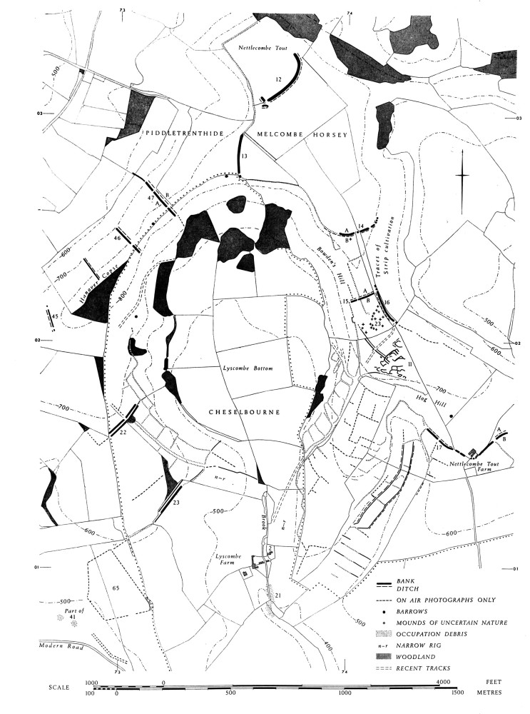
The pattern of fields, now destroyed, in the valley S.W. of Hog Hill differed in the S. and the N. half. In the S. a regular series of lynchets about 2 ft. high crossed the valley bottom at intervals of some 50 yds. Low mounds 15 ft. to 30 ft. across lay on three of these lynchets in the middle of the bottom (cf. Dorset II, Ancient Field Group (15)). Slight banks continued the line of the lynchets up the E. side only, against a slope of 16°. To the N. of this area the valley bottom, some 10 acres, was enclosed by a low bank, 6 ft. across, with uphill ditch cutting over widely spaced cross-valley lynchets which rose up both sides of the valley on slopes of over 19°. A continuation of the E. bank and ditch partly blocked the valley bottom at the S., but there was no trace of it in disturbed ground below the steep head of the valley.
The fields as a whole date almost certainly from the Early Iron Age at latest (cf. dyke Melcombe Horsey (15)), at least to a late point in the Roman period, as indicated by the settlements and by finds in the fields (e.g. Dorset Procs., 76 (1956), 76). The only traces of strip cultivation, on the E. shoulder of Bowden's Hill, as high as 800 ft. O.D., are mediaeval or later.
The concentration of dykes is rare, but has parallels, for instance near Cold Kitchen Hill, Brixton Deverill (V.C.H., Wiltshire, 1. 1) where, again, Chalk ridges partly surround lower ground. The form of the dykes is varied. Relationship to the other earthworks is not always certain. Two cross-ridge dykes, Melcombe Horsey (13) and (14), face away from the incomplete hill-fort on Nettlecombe Tout (Melcombe Horsey (12)) and are joined to each other by a high scarp with a ditch at its foot for part of the way. The total area contained between this, the shoulder of the hill at the 800 ft. contour, and the hillfort, is about 70 acres. Dykes Cheselbourne (22) and (23), Piddletrenthide (46) and (47), and Melcombe Horsey (15) have ditches towards the hill-fort, i.e. uphill, as has the slight bank, conceivably ancient, between Piddletrenthide (46) and (45); but (45) has its ditch on the side away from the hill-fort. With the possible exception of Melcombe Horsey (15), the siting and size of the dykes indicate that they are not defensive. Cheselbourne (22) probably blocks a double-lynchet track, but dense scrub and disturbance prevent certainty about this. Three dykes, Melcombe Horsey (15) and Cheselbourne (22) and (23), are built on or across 'Celtic' field lynchets. Such relationships indicate a relatively late date for these particular dykes in their present form, but since, as is the case with (23), their lines are in places continued by lesser banks and scarps, it is possible that the dykes themselves represent the local building-up of parts of earlier boundary lines. Banks and ditches running down steep slopes from the ends of dykes, continuing dyke Piddletrenthide (47) to both S.E. and N.W., and continuing Melcombe Horsey (15) to the W. (not illustrated), could be later. However this may be, there is no doubt that the area was eventually divided into blocks by long boundary lines. The dykes unrelated to ridge-tops, Melcombe Horsey (16) and (17), and Cheselbourne (23), emphasise this. The first, with extension S.E., could be ⅓ mile long; the second, 500 yds. long, running between the heads of two valleys, is continued N. for over 300 yds. by a long scarp, while the third is continued by a scarp up to 5 ft. or more in height, connected with the N.E. angle of enclosure Piddletrenthide (65).
Air photographs: CPE/UK 1974: 2370, 4364–8; CPE/UK 1934: 2097, 3180–1, 5180–1; Cambridge University Collections, verticals K. 17, E.149–151, 154–6, 160, 161, 163; obliques NK 90, AMN 53–6, ANF 39 and 41.
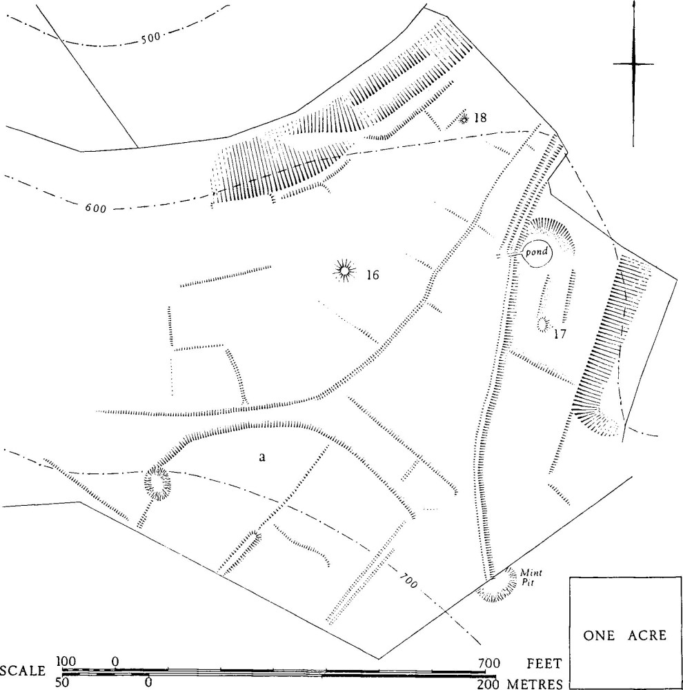
Group (45): Dole's Hill. (Piddlehinton, Piddletrenthide and parts of Cheselbourne, Dewlish and Puddletown. Folding map in end-pocket; Plate 87). (fn. 2) 'Celtic' fields, now mostly destroyed, were virtually continuous over at least 2,000 acres on either side of the Lise brook, N. from Home Eweleaze, Puddletown (SY 743958) to Kingcombe (ST 741002). Thence they continued without a break to Lyscombe (Group (44)). They lay on Middle and Upper Chalk, in places capped by clay, between about 220 ft. and 550 ft. above O.D. The drainage system, from N. to S., and the general southward fall of the ground on the dip-slope of the Chalk, leave very few N.-facing slopes. Former open fields, of Piddletrenthide on the N.W. and of Cheselbourne on the N.E., abut on the area. In Puddletown, on Home Eweleaze, remains of strip fields, presumably of the settlement of Hyde, are still traceable superimposed on 'Celtic' fields. Some of the downland, e.g. Peak at the extreme W. of Dewlish, was arable in the mid 19th century (Tithe Map, 1844). No certain settlements survive as earthworks, but two may be roughly placed by surface concentrations of occupation debris. The first is Dewlish (10), Romano-British, where air photographs show a feature 50 ft. square at 75479852, the site being perhaps significantly close to the destroyed enclosure Cheselbourne (40), undated, but probably of the Iron Age. The second, (a) in Puddletown, lies S. of Well House cottages, about 742966, and is of Iron Age or Romano-British date (Plate 87). One other settlement (e), about 737989, further considered below, is chiefly suggested by arrangements of tracks on Hog Leaze, N. of Dole's Hill (736990). A small ploughed enclosure (b), still visible, is integrated with 'Celtic' fields on Dole's Hill, Piddlehinton, and air photographs suggest the possible former existence of enclosures other than fields at (c), 72959887, in Piddletrenthide, at (g), S.E. of New Barn, Cheselbourne (754996), and at (f), 74499884, on Cheselbourne West Down; these are located on the map, but not delineated. The last, D-shaped, is comparable in size, shape and apparent situation with (a) in Group (35), Nether Cerne. Saxon charters indicate the recognition of a 'castel' (walled structure?) near (b), and a sacred place by the stream E. of (e).
The only certain tracks associated with the 'Celtic' fields are at (e). There is a likely continuation from this area E.S.E. across Cheselbourne West Down and the possibility of a continuation W.N.W. past barrow Piddletrenthide (51). There are indications of tracks elsewhere, e.g. running S.W. towards barrow Cheselbourne (34) and N.E. towards settlement area (a), but the first is on the line of an abandoned through-route from Dorchester to Shaftesbury and the second has, at least in part, been followed by later hollow-ways. A road from Plush to Dewlish, certainly later than the 'Celtic' fields, was once a deep hollow-way cutting diagonally across settlement (e), (Plate 87). A narrow track or ditch, visible only on air photographs, and perhaps contemporary with some phase of the 'Celtic' fields, ran southwards past barrow (24) on Cheselbourne West Down. A low bank and ditch (x) in Piddlehinton, at the extreme S. of the group, is later than the 'Celtic' fields there.
The alignment of the fields in the N. half of the group is markedly along a N.W. to S.E. axis. This is continuous, though broken physically, across the Lisc brook, and is unaffected by the lie of the ground. Further S., the alignment is generally the same to E. of the stream, but it changes slightly on the W., where it is congruent with the pattern of tracks at (e). There are no suggestions of boundary lines other than the stream S. from (e), an unassociated low bank (d) running N.E. across Eweleaze, N. of Dole's Ash Farm, and the tracks and ditches already mentioned. A narrow band, at the most 80 yds. across, was probably uncultivated along the line of the brook.
Original field sizes appear to run from ½ acre to 1½ acres. Fields which appear to be larger than this are almost certainly the result of destruction of field sides. Shapes are generally rectangular and proportions of length to breadth less than 2½: 1. Fields of irregular shape are notable W. of the probable settlement area (a) in Puddletown, where the turn of the spur may be partly responsible, and S.W. of barrow Puddletown (51), 741973. Immediately N. of the latter is a long field, 110 yds. by 30 yds., and another of the same dimensions occurs S. of the tip of Dole's Hill at 93839785. There are others on Cheselbourne West Down. The fields about 220 yds. long on Home Eweleaze, Puddletown, N. of Druce Farm, are almost certainly a consequence of mediaeval strip-ploughing. Lynchets were generally well-developed, frequently up to 6 ft. high on gentle to moderate slopes and up to 20 ft. high where they incorporate a natural shoulder on the edge of the stream.
Dating evidence is scanty. Round barrows, probably of earlier date than the fields, were apparently respected and generally lie by field angles or sides. The known or suspected settlements probably associated with the fields in different phases range from Iron Age 'A' to Romano-British. Pottery found on the fields is of corresponding date (Dorset Procs., 74 (1952), 87–9). References in the 9th century A.D. to walled enclosures and to a (?) holy place on the Lisc brook have been discussed by Grundy (Dorset Procs., 56 (1934), 115 ff.). Enclosure (b) on Dole's Hill is now the nearest recognisable walled or banked enclosure to the 'castel' which is mentioned in Saxon Charter B 525 K. 300, 5, after reference to the lynch, apparently above the brook W. of barrow Cheselbourne (24). The 'burnstow' was on the stream to the N., possibly below (e).
The suggestion of settlement in this area (e) is based, firstly, on the very unusual angular 'U' pattern made by the tracks. With the stream as the fourth side, these enclose a sloping area of nearly 12 acres. The bounding tracks were variously of double-lynchet form, with tread about 18 ft. wide between flattened scarps 1 ft. to 3 ft. high, or sunken 2 ft. or so between banks which were in places very flinty. The overall width is 30 ft. to 40 ft. Both sides seem to have continued down to the stream, the northern first making an angular turn N. A slight hollow and texture mark in grass continues the S. side, eastwards uphill, on Cheselbourne West Down. The interior shows incomplete and rounded remains of scarps, some still 5 ft. high, apparently lynchets. A once clear double-lynchet track with tread 13 ft. wide between lynchets up to 5 ft. high climbs around a moderate slope to join the rectangle near its S.W. angle. At the N.W. angle the banks defining the feature splay into an open triangle, with darkened earth but with no small finds. An air photograph (Plate 87) suggests former ditches here underlying the latest pattern of earthworks. There is no proof of the probable connection between this area and the shallow hollowed track system passing S. of barrow Piddletrenthide (51), 600 yds. W.N.W.
Air photographs: CPE/UK 1934: 4102–7; 1974: 1363–4, 2365–7, 3363–9; 58/RAF/5768: 0028–38; Cambridge University Collections, vertical, K.17, E.142–7; obliques, LR 45–62, AGT 17, 18, 23.
Group (46): Manor Farm and Henning Hill (Cheselbourne and Melcombe Horsey). 'Celtic' fields are traceable from N.N.W. of Manor Farm, Cheselbourne, to Henning Hill, Cheselbourne and Melcombe Horsey, between ST 750008 and 767018, over about 100 acres of Chalk downland. They lie between about 400 ft. and 650 ft. O.D., mostly on the steeper hill-slopes, but in one place, ¼ mile N. of Manor Farm, crossing the valley bottom. They formerly continued in all directions. Some destruction by strip ploughing is apparent N.W. of Manor Farm and on the slopes of Henning Hill, especially on its N.E. side (cf. Melcombe Horsey (10)).
An original pattern recognisable over some 20 acres N.W. of Manor Farm includes long fields but only one is complete, 170 yds. long by 20 yds. to 30 yds. wide. Slopes here are from 5° to 16°, lynchets 3 ft. to 9 ft. high.
On the N. tip of Henning Hill, at 75950197, is a pentagonal enclosure, probably an altered 'Celtic' field about ⅓ acre in area, delimited by a massive lynchet on the N., a low bank 12 ft. wide on the E. and traces of bank or lynchet elsewhere. Poor remains of 'Celtic' fields lie around it.
Air photographs: CPE/UK 1934: 1151–2.
Group (47): Whitelands Down (Cheselbourne and Dewlish). 'Celtic' fields, very disturbed, are traceable on three areas of Whitelands Down in Dewlish and Cheselbourne parishes between under 300 ft. and over 400 ft. O.D. About 30 acres lie between SY 770993 and ST 773002; some 12 acres lie on the W.-facing slopes N.E. of Chebbard Farm, about 767986; 15 acres lie on ground falling S.E. towards Dewlish Mill, at 778992. There is a possible settlement (a) in the first-mentioned block, at 770996. There is much evidence for past ploughing; it includes narrow ridge-and-furrow, which appears to have lain over 'Celtic' fields on Whitelands Down, 773001. (CPE/UK 1934: 1150.)
Details on the Tithe Map (c. 1843) indicate that 'Cheselbourne East Field', at N.W., and other areas to S. and E. were formerly ploughed. Most of the area is modern arable showing spreads of flints and patches of clayey loam. A series of hollow-ways rises W.N.W. from the road junction at 77430030, on the line of Streetway Lane, with very faint remains of 'Celtic' fields to N. and S. At the S.E. the modern road N. of Dewlish can be seen to cross 'Celtic' field lynchets which terminate against a scarp up to 6 ft. high bordering the Devil's Brook. Only this stream and the narrow flat band of land along it separate this group from Group (48).
Possible settlement at (a), on the top and on the gently falling E. slope of a spur S. of Callway Lane, is suggested by a 100 yd. length of track, 18 ft. wide, with scarp uphill 3 ft. high and downhill 6 ft. high, which runs S., with a pronounced bow E. not required by the lie of the land, from about 77019965, where it was probably blocked by Callway Lane. South of this section of track its downhill side seems to describe a further bow to the S.W., the uphill side forming a chord about 80 yds. long across it. There are other suggestions, on air photographs, of a curiously sinuous continuation S. The very disturbed area W. of the track contained scarps among which, at 76959954, against the N. side of a hedgerow, was a curved flinty bank (b), possibly the remains of a dished circle, some 30 ft. across, cut by the hedgerow.
Fields are generally too broken to declare original sizes, but there is a notably regular pattern of long scarps laid off either side of a base line, around 773999. Subdivisions may have been destroyed, but field widths ranged from 30 yds. to 55 yds.
Air photographs: CPE/UK 1934: 1150–3; 1974: 2361–3.
Group (48): Bramblecombe (Cheselbourne, and nearby areas in Dewlish, Hilton, Milborne and Milton Abbas. See map on p. 334). 'Celtic' fields, generally much disturbed and mostly ploughed over, but including prominent earthworks, are traceable over some 400 acres of Chalk, widely capped by Clay-with-flints, between the Devil's Brook on the W. (about 300 ft. O.D.), the Cheselbourne/Milton parish boundary on the E., Coombe Hill, Hilton, on the N. (667 ft. O.D.), and Dewlish Mill on the S. They are described below in blocks from N. to S. although they were probably continuous and formerly continued in all directions, as did an outlying and greatly disturbed block of some 20 acres E. of West Bagber Copse (around SY 792996) in Milton Abbas parish, crossing the boundary with Milborne. Fields where preserved had sides up to at least 70 yds. long. Areas were up to 1½ acres. Forms apparently triangular in block (i) are not original.
Settlements cannot be located with certainty in the main area, but there are several notable features. In block (ii) are a bank (a) cut by the Cheselbourne/Hilton parish boundary, a very disturbed area (b), and a well-preserved and unusual stretch of double-lynchet track. Block (iii) contains a small roughly rectangular enclosure (c) of unknown date. Coarse potsherds, Iron Age or Romano-British, as well as samian, were found in the area of (a) and (b) as well as elsewhere on the fields. Undated and complex features with elements later than 'Celtic' fields include remains of massive scarps associated with ditches or tracks at about ST 77530075. These bound an almost rectangular area of ½ acre on a slope of 17° cut by hollow-ways and present hedges E. of Cheselbourne Mill, W. of the area shown on p. 334. 'Celtic' fields lie immediately E. A bank and ditch, later than the 'Celtic' fields, formerly enclosed Combe Bottom (block (i)). Secondary disturbance by an unusual form of ridge-and-furrow ploughing occurred in Bramblecombe (block (ii)). An almost certain settlement of Roman date lies close to the Bagber fields on the E. (Milton Abbas (26)). Round barrows in the area are along the sides of fields or at their angles; in areas of great disturbance such as S.W. of Common Barn (block (ii)) some mounds (not numbered) may be the remains of field angles only.
Block (i), Hilton parish. Some 35 acres of broken 'Celtic' fields remain in and around Coombe Bottom, with traces ½ mile N. on Coombe Hill at 778025. Scarps N. of Coombe Bottom are up to 20 ft. high, but there is no complete pattern and a line of probably later ploughing marking the N. shoulder is responsible for a sharply triangular field shape. Below this field, at 77670173, is an unexplained rounded 'platform' 90 ft. by 25 ft. with scarp up to 30 ft. high. There has been much quarrying. The valley bottom, covering some 9 acres and including faint traces of 'Celtic' fields, is largely contained by an enclosure (32), shown on the Tithe Map of 1842 and partly shown on O.S. maps; it has a bank and an uphill ditch, each about 8 ft. across, the ditch being 2 ft. deep. The ditch cuts through 'Celtic' field lynchets.
Block (ii), immediately S. of (i), includes Bramblecombe, around 778013, with prominent earthwork remains, and the area E. and S. of it to the parish boundary with Milton (see p. 334). A double-lynchet track is prominent, running W. at the head of the coombe. The upper lynchet is absent in the lower parts of the valley head, where there is a plantation and some disturbance. Its gentle curve, rising around the slope, and some wear of the track, perhaps due to re-use, give a false impression of constructed banks. Air photographs show that it probably continued S. to a point E. of area (b), opening into a splay at 78170123. A faint scarp marks its continuation N. from Bramblecombe. The disturbed remains of roughly rectangular fields that covered Bramblecombe were seen to have been ploughed over by very low ridge-and-furrow about 11 yds. wide. This swept up the N. valley side, on slopes of 19°, marking the final destruction of substantial lynchets along the contour. Other lynchets survive up to 6 ft. high. A barrow, Hilton (30), is placed on the line of a field edge which it probably pre-dates. About 120 yds. S.W. of this, at 77670127, a ploughed bank (a) occurs in an area covered by Clay-with-flints; it is up to 4 ft. high and 30 ft. wide and it curves gently for 110 ft. S.W. from, parallel with and then sharply towards the parish boundary, which crosses it. The bank appears to be part of an enclosure integral with the 'Celtic' field system, possibly developed from a field. Area (b), at 78020115, is an uneven area of uncertain extent, formerly much ploughed. It is on an almost flat shoulder with ground rising gently E. and N.; here, in an area of Claywith-flints, samian fragments have been found amongst very faint 'Celtic' field traces (Dorset Procs., 76 (1956), 76). Between this area and the parish boundary with Milton Abbas the Tithe Map shows that in 1841 there were 47 'furze allotment' strips; these, however, do not correspond with marks on air photographs. To the S. of this, E. of Common Barn (78200064), are faint traces of 'Celtic' fields together with an unexplained strip 130 yds. by 10 yds., its S.W. end at 78320060. Earthwork remains W. and S.W. of Common Barn (on very flinty broken-up ground where there is an exposure showing 1 ft. of Clay-with-flints on the Chalk) include narrow rig, mounds of uncertain origin, and relatively late banks in an area where 'Celtic' fields were once widespread. Romano-British and possibly earlier pottery has been found on the fields (Dorset Procs., 76 (1956), 76–7). Former ploughing and land divisions have broken or confused the original pattern. An apparent double-lynchet track 20 yds. from Common Barn, parallel with its S. side, might result from unconnected phases of activity, as might the flinty bank extending nearly 400 yds. W. from this to meet a modified 'Celtic' field lynchet. A mound 45 yds. S. of the double-lynchet, jutting W. from the present hedge, is spur-like, measures 20 ft. across its top, and falls 3 ft. to S. and W. A mound 370 yds. S.W. of this, at 780004, could be a flinty field angle or a barrow at a field angle. Some 370 yds. further S.W. is a disturbed fragment, probably of a double-lynchet, up to 15 ft. high, apparently marking a track from the Devil's Brook; it has been buried by ploughsoil at the N.E. end.
Group (48): Blocks (ii) and (iii)
Block (iii), continuous with the foregoing at the S. of the group, in Milton Abbas and Dewlish parishes, has remains which are generally less disturbed, but on Woodsdown there has been much secondary ploughing. This has broken down 'Celtic' field divisions, but in places has left the stubs of the field sides. In this area is a ploughed-over trapezoidal enclosure (c), about 75 ft. by 42 ft.; it is defined by a probably 'Celtic' lynchet falling 2 ft. from its longest side on S.W., and elsewhere by a low bank up to 12 ft. across. Further S., where crossed by the Milton/ Dewlish parish boundary and southwards, the fields on the 100 ft.-high slope rising E. from the Devil's Brook are relatively well-preserved, with lynchets up to 6 ft. high.
Air photographs: CPE/UK 1934: 1150–3, 2109–14, 3107–10, 5108–10; 1974: 2365–7.
Group (49): Little Down (Hilton). 'Celtic' fields covered the whole of Little Down; they are well-marked E. of ST 775034, and they are just traceable N. of it around 77670364, but disturbed by strip ploughing; there are also traces S.W. of it, about 775030, in a field said to have been steam-ploughed before 1914. The area, between 600 ft. and 650 ft. O.D., totals about 25 acres.
Little Down itself is a spur of Middle Chalk capped by Clay-with-flints. The ground falls away from it in all directions except N.W. Despite prominent individual lynchets, a variety of disturbance including extensive shallow quarrying has destroyed the original pattern and has obscured the shape and size of single fields. Some sides were between 30 yds. and 70 yds. long.
Air photographs: CPE/UK 1934: 3108–9.
Group (50): Cuckoo Lane (Hilton and Stoke Wake). 'Celtic' fields, considerably altered, survive on parts of the W.-facing slopes of the spur S. from Bulbarrow, between 600 ft. and 800 ft. O.D., partly on Clay-with-flints over the Chalk. They formerly extended into Stoke Wake parish where, N. of Bulbarrow, dyke (7) impinges on fragmentary remains. A pattern is detectable only over some 8 acres immediately W. of Cuckoo Lane, extending N. from ST 774048 to the boundary with Stoke Wake parish.
A series of roughly parallel E.–W. lynchets 30 yds. to 40 yds. apart runs down the slope to a substantial lynchet on the W. shoulder of the spur. N.-S. field divisions between them are generally destroyed or altered. There is a double-lynchet with lower scarp 7 ft. high running S. for 80 yds. from the parish boundary at 77450412.
Air photographs: CPE/UK 1934: 1078–9.
Group (51): Hilton Bottom and Green Hill (Hilton and Milton Abbas). 'Celtic' field remains, very much disturbed, are distinguishable over some 80 acres between about 500 ft. and 800 ft. above sea-level, from W. of the head of Hilton Bottom, 777046, to Green Hill Plantation, Milton Abbas, 796037. Most are on the sides of the ridge S.E. from Bulbarrow between Groups (50) and (52). Clay-with-flints caps the Chalk over the higher half of the area and there is some sand about 784044. There has been much soil-slip on slopes of up to 27°. No certainly complete original fields survive, but many lynchets are massive, exceptionally up to 30 ft. high. There has been extensive ploughing on the summit of the ridge and also below the 600 ft. contour, below which little is detectable. At the extreme N.W. of Hilton Bottom there are traces of ridge-and-furrow over 'Celtic' fields. There are numbers of deep quarry pits among the fields as well as shallower quarries. Some of the latter are regularly disposed and notably rectangular, though with sloping 'floors'. A row of such pits is cut into a lynchet on Green Hill at 79200392. Some sub-rectangular platforms superficially resemble the earthworks of a form of settlement; they lie uphill of a long scarp, 10 ft. high, E. of Shop House Plantation, around the 600 ft. contour at 794037. Abandoned banks of relatively late date further confuse the remains. One, W. from 78510447, partly shown at (x) on p. 335, is 6 ft. across and has ditches 3 ft. wide and 2 ft. deep on either side. Disturbed field remains are probably cut by a substantial park pale, following the line of boundaries shown by O.S. between 78940377 and 79330371, N. of Horse Park Plantation.
Group (51): Hilton Bottom and Green Hill
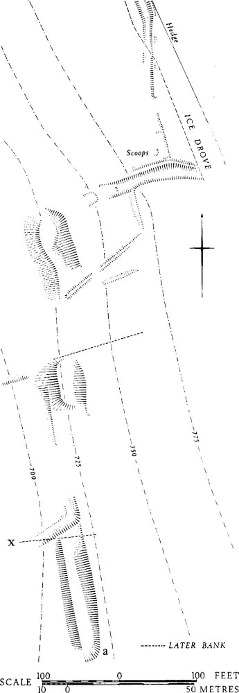
Group (51): Platforms and Hollow-ways at (a)
Group (53): Meriden Down, Houghton South Down and Green Down
Undated and unexplained features, complex or much disturbed, include: (a) 'platforms' and hollow-ways over some 250 yds. on the upper W.-facing slopes above Hilton Bottom between 78430440 and 78400460 (see p. 335); (b) incomplete indications of a rounded enclosure of perhaps 4 acres, with a ploughed bank up to 27 ft. wide, centred at 785040; (c) a feature defined by a scarp up to 5½ ft. in height, with N.W. corner rounded, about 790036, E. of the Hilton/Milton Abbas parish boundary and in indeterminate relationship to it. The 'platforms' in area (a) are generally prominent, but the surfaces of the smaller examples slope up to 8°. The hollow-ways at the N., up to 2½ ft. deep, are probably earlier than the ridge-way, Ice Drove. The terrace, 50 yds. long and 4 yds. to 5 yds. wide at the S. of the area, is immediately above a 'Celtic' field. The lengths of a terrace-way which approach area (a) from the valley bottom do not accord with the lie of the 'Celtic' fields.
Air photographs: CPE/UK 1934: 1078–9; 2431: 3340–1.
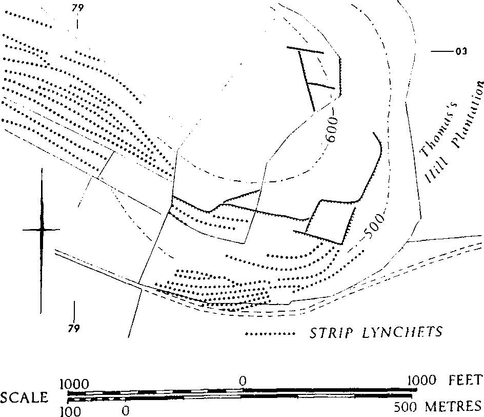
Group (52): Thomas's Hill (Hilton). 'Celtic' fields are recognisable over approximately 5 acres on the tip of Thomas's Hill, between 792027, 795027 and 794030. The subsoil is Chalk and there is much surface flint. The remains, mostly much altered, survive on the fringes of strip cultivation (Hilton (29), (a)) which has probably destroyed others. Later ploughing and tree planting have added to the destruction.
Air photographs: CPE/UK 1934: 3110–11.
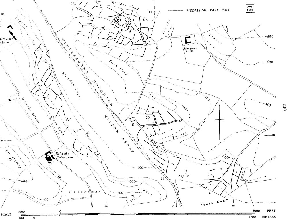
Group (53): Meriden Down, Houghton South Down and Green Down (Winterborne Houghton and Milton Abbas. Plans, opp. pp. 298, 299, 336, 338; Plate 88). 'Celtic' fields, some of them exceptionally well-preserved, lie within 200 acres between Crincombe and Delcombe Bottoms (ST 791051–800035) on the W., and a line from near (Higher) Houghton Farm (810046) to Houghton South Down (811037) on the E. There are very faint traces indicating former extension E. along South Down into Winterborne Stickland (824043). A further 20 acres of almost flattened fields N. of Milton Abbas village (804019–807023), ½ mile S.E. of Crincombe, are treated as an outlier of the group. There are suggestions on air photographs that these fields continued S. of the village on to Luccombe Hill (CPE/UK 1934: 1144 and 3113). Almost all are between 500 ft. and 750 ft. O.D., on Upper Chalk and some Clay-with-flints, along the W. side of a ridge and on the spurs E. from it. The ridge top is capped by Clay-with-flints and has a number of ponds.
There are two certain settlements, S. of Meriden Wood (Winterborne Houghton (9)), and by Bully Wood (10), ½ mile S. Both settlements are associated with well-marked contemporary roads. A possible third settlement, (a), lies ½ mile further S.E. Some platforms, (b) and (c), on Green Down, are of uncertain date and purpose, as are a nearby mound (d) and some banks and mounds, other than barrows (16)–(18), on Houghton South Down. Dyke Milton Abbas (27), on a spur N. of the village, is partly built on a 'Celtic' field lynchet.
The alignment of the fields in the N. of the group is generally N.E. to S.W.; this suggests a connection between Meriden and Green Down. Although in the intervening area there are no fields traceable in Blagdon Copse, incomplete fields preserved along its W. edge once ran into it and there are faint remains on Clay-with-flints towards the N.W. tip of Park Wood. Nothing survives to indicate any boundary between the fields of settlements (9) and (10). The lie of their roads E. suggests that they led to water in the Winterbourne below (cf. tracks to Lyscombe Bottom in Group (44)). The road S.E. from (9) was built along the edge of 'Celtic' fields whose lynchets were already well developed. Part of the settlement was also built out on to previous fields in its S. parts, and in settlement (10) the S. ditch of the partial enclosure N. of barrow (20), itself almost certainly at a former 'Celtic' field angle, cuts into and runs along a 'Celtic' field lynchet. The close proximity and easy intervisibility of the two settlements is emphasised on Plate 88, which shows the massive lynchets, frequently over 10 ft. high, just S. of (9).
Lynchets on Green Down are of comparable proportions; they are frequently 6 ft. high and some of them reach a height of 20 ft. (e.g. at 79530471), having a slope 50 ft. long from top to bottom. The field slopes here are up to 8°, elsewhere up to 22°. Sizes of complete fields vary from ½ acre to 1 acre. At least two fields of this larger size, N. of Green Down, seem to have been formed by the joining together of smaller fields. The most attenuated is 125 yds. by 30 yds. About 79940390, scarps in a disturbed area are only 18 yds. to 24 yds. apart; their E. ends are destroyed in Blagdon Copse. One small lyncheted plot immediately S.E. of the nucleus of settlement (9) was probably a garden.
The roads through the fields around (9) are now marked on the flat by low banks (road b), and on slopes by lynchets which may have banks built on them (road a), (plan opp. p. 300). The tracks are from 10 ft. to 24 ft. wide. The road E. from settlement (10) is 12 ft. wide and is similarly embanked or lyncheted.
Group (53). Feature (a) and associated earthworks on Houghton South Down
There has been extensive disturbance over parts of the group. On Green Down the 'shelf' (b), 40 ft. by 10 ft., above a 'Celtic' field lynchet, and the terrace (c), 150 ft. long, 20 ft. wide at the N. and 40 ft. wide at the S., could result from secondary activity, as could the irregular mound (d), 60 ft. across and 3 ft. high, which projects W. of an apparent 'Celtic' field angle. Feature (a) embodies, on almost flat ground, a quarter circle defined by short straight stretches of scarp and suggests the former existence of a roughly circular enclosure of about 4 acres, possibly of the early Iron Age. The bounding scarp, without any sign of a flanking ditch, is about 4 ft. high in the N., where for a length of over 300 ft. its face has been dug for flints. In the N.W. it has been interrupted by a quarry pit, which could be on the site of an entrance. The E. side of (a) is marked by low parallel banks, each 12 ft. across, divided by an uneven sinking which may indicate robbing of a former single bank. Subdivisions of the interior might mark occupation or conversion into fields, themselves largely destroyed. A mound 120 ft. long, jutting N. from the modern hedge, increases in height from 1 ft. to 3 ft. at the N. end (plan, p. 338). East of (a), the long curving scarp which runs N. and N.E. from Mint Pit is flanked by a later track on the W., and on the E. it falls 2½ ft. to 4½ ft. to remains of 'Celtic' fields which probably are contemporary with it. These fields are partly overlain by later ridge-and-furrow. The pond is relatively recent. The long bank, 12 ft. across and up to 2 ft. high, W. and N. of (a), is variously scarped on both sides, probably by cultivation. It makes slight angular deviations in its course and has low scarps butting against it on both sides, presumably 'Celtic' fields which have subsequently been almost flattened. About 230 yds. W. of (a), at 806037, on a gentle N.-falling slope, are remains of a slight bank (? enclosure, date unknown) with outer ditch forming an angle of 80°, with sides about 180 ft. by 80 ft.; it lies immediately E. of the small mounds Winterborne Houghton (13–15). The track still visibly skirting this area was shown on O.S. 1811 as a road linking Winterborne Houghton to the ridgeway. Dyke (11), 100 yds. further N.W., is probably contemporary with the 'Celtic' fields.
Air photographs: CPE/UK 1975: 1026–9 (S. of area) and 1974: 5169–73 (N. of area and Winterborne Stickland).
Group (54): Ibberton, Sturminster and Woolland. 'Celtic' fields, now largely destroyed, are traceable over some 70 acres in the E. half of Ibberton and, N., in the nearer parts of Sturminster on Bell Hill (ST 797082), and in Woolland on Woolland Hill to 774061. Most of the fields lay between 400 ft. and 800 ft. O.D., on Chalk and Clay-with-flints. There has been considerable disturbance by ploughing in the past. Strip lynchets in Coombe Bottom (Ibberton (10)), themselves overploughed, probably impinged on settlement Ibberton (11) and associated 'Celtic' fields. Strip lynchets apparently also lie over 'Celtic' fields on Ibberton Hill at 791072.
The pattern was clearest on South Down from 795064 in the S.W. to just E. of settlement (11) at 807069. Lynchets on the rounded top of the spur were up to 4 ft. high and those on the steep slopes to the S. were up to 15 ft. high. Field sizes were from ¼ acre to 1¼ acres. Air photographs show a stretch of track running between 'Celtic' fields along the shoulder S. of the settlement (CPE/UK 1934: 2170–1). It was continued E. by a long lynchet which was joined by curving scarps to the small enclosure at 80660691, probably part of the settlement. Fields continued in all directions and there are faint indications of a connection with further broken remains in Winterborne Stickland, E. of Stickland Wood (820068) (CPE/UK 1974: 1173–4).
There is no direct relationship to dykes, although a few isolated and disturbed 'Celtic' fields lay N.W. of Woolland (7), N. of Bulbarrow (CPE/UK 1934: 2175), and lynchets lie parallel to, and N. of, Ibberton (13) on Bell Hill.
Other air photographs: CPE/UK 1975: 2025–7 (South Down).
Group (55): Ringmoor (Turnworth). Some 30 acres of 'Celtic' fields lie around the contemporary native settlement Turnworth (7) on Ringmoor (ST 809085) (see plan facing p. 291) and formerly extended in all directions. They lie between 700 ft. and 800 ft. above O.D., entirely on Clay-with-flints. On the N. the group is bounded by a winter bourne, beyond which are further 'Celtic' fields (Group (56)). There has been some destruction of field sides by ploughing at an unknown date, so that most of the remaining fields, on plan, are much bigger than they were originally. Lynchets are from 2 ft. to 6 ft. in height.
Group (56): Turnworth Down (Turnworth). 'Celtic' fields survive in much broken and altered form within some 60 acres on Turnworth Down and The Cliff, N. and E. of Group (55), on Upper Chalk between 500 ft. and 750 ft. O.D. on valley sides generally facing S.
On the N. a lynchet 7 ft. high extends along the N. side of a winter bourne at ST 810089; other lynchets in pasture to the E., on slopes up to about 10°, are 3 ft. to 15 ft. high and are occasionally defaced by shallow quarrying. Many lesser divisions have been at some time ploughed away, though banks 12 ft. wide and 1 ft. high survive, running down the slope about 813090. N. of this area the fields seem to stop short of the sand-andgravel capped E.-W. ridge at about 810090. To S.E., E. of the present road, around 817087, a further broken pattern of large lynchets, on the same general alignment, occurs in pasture on slopes of up to 15°. The pattern on the upper slopes and in arable land to the E. suggests the proximity of settlement. The possible settlement on Bonsley Common, noted in Shillingstone (25), lies about ¼ mile N.E. between this group and Group (57). To the S., strip lynchets and ridge-and-furrow on the Cliff (Turnworth (6)) overlie 'Celtic' field remains about 818083. There are further greatly disturbed traces S. of Turnworth House, 816080.
Air photographs: CPE/UK 1934: 4168–9; 1975: 4024–5.
Group (57): Okeford Hill (Okeford Fitzpaine and Shillingstone). 'Celtic' fields, much altered, cover about 80 acres of the spurs projecting N. from Okeford Hill between ST 808094, 808098 and 824097, at 500 ft. to 700 ft. O.D. There are also traces of 'Celtic' fields N. of dyke Okeford Fitzpaine (40), 600 yds. to the S.W., at 803090.
On the W. parts of Okeford Hill the fields partially survive only W. of the road to Okeford Fitzpaine. Here they are on Upper Chalk and seem not to have intruded on to the angular flints, sand and clay which cap the ridge immediately S., separating them from Group (56). Only two or three original fields are intact; they are from ⅓ to 2/3 acre. Substantial overploughing and shallow quarrying have reduced or levelled former sides although the surviving lynchets are up to 7 ft. high. A hollowway up to 4 ft. deep, later than the fields, runs up the spur W. of the modern road following a line of 'Celtic' field lynchets. At 80870975 a slightly hollowed double-lynchet feature of uncertain origin, 21 ft. wide, runs W. downhill.
To the E. of the road to Okeford Fitzpaine the remains have been ploughed almost flat. A dyke, Okeford Fitzpaine (41), now destroyed, was integrated with 'Celtic' fields whose sides sprang N. and S. from it, indicating field widths of 30 yds. to 70 yds. (CPE/UK 1934: 4169). To the S.E., on Clay-with-flints, the much broken remains link up with those around dyke Okeford Fitzpaine (42) on the E. parts of Okeford Hill, investigated before the fields were levelled. The lynchets on the Chalk spur were almost entirely low, about 2 ft. Some divisions had been removed by previous secondary ploughing. The long line of lynchets at E. had attained a height of about 3 ft. before the dyke was built over it.
Air photographs: CPE/UK 1975: 4024–5; 1944: 1327–8.
Group (58): Shillingstone Hill (Shillingstone). 'Celtic' fields once covered Shillingstone Hill from ST 828100 on the W. to 845093 at the extreme S.E. of the parish and formerly continued in all directions. Until destruction during afforestation, the remains were prominent over some 120 acres of the E. end of Shillingstone Hill.
All the fields were on Chalk between 300 ft. and 600 ft. O.D. The area was Common Pasture in 1839 (Tithe Map), but the 'Celtic' fields had been altered and disturbed by strip ploughing, particularly on N. and E., and many lynchets, often 6 ft. high, had been dug along for flints. A double-lynchet track can be traced for 700 yds.; it probably ran from the vicinity of the R. Stour to the settlement, Shillingstone (25), at the extreme W. of this group. Towards the summit of the hill its course was sinuous. It had been hollowed for part of its length as a result of re-use. An oval enclosure (Y), of ½ acre, now flattened, lay at 841092. The line of lynchets N.E. from a point just S. of this enclosure was probably a boundary. 'Celtic' fields downhill of it are generally narrower and longer (up to 100 yds.) and are defined by relatively low lynchets and banks.
Settlement (25) and the whole of the hilltop W. of it, capped by Clay-with-flints, had been disturbed by tracks, quarrying and, possibly, by ploughing. 'Celtic' field remains here were slight but definite and joined with those, also much broken, on the spur (828100) at the W. of the group. Fields ran down to Eastcombe Bottom E. of the spur, but they had been flattened by strip ploughing on the W. side. Dyke (26) was built over 'Celtic' lynchets.
Original fields in the main block were apparently 3/5 acre to 1 acre in size, field sides ranging from 33 yds. to 80 yds.
Air photographs: CPE/UK 1934: 4163–5; 1944: 1323–6; 1975: 4020–2. Cambridge University Collections, obliques, CS 59–61; LR 23; AEL 53; ANF 19, 21. (cf. H. C. Bowen, Ancient Fields (1961), frontispiece and Plate 1.)
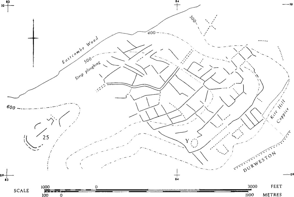
Group (58): Shillingstone Hill
Group (59): Winterborne Stickland and Winterborne Clenston. There are traces of 'Celtic' fields over large areas of Winterborne Stickland parish, the biggest block extending N. and N.W. from Winterborne Stickland to N. of Normandy Farm, where the parish boundary about ST 842063 runs across 'Celtic' fields continuing into Bryanston parish. All the fields are on Chalk between about 300 ft and 500 ft. O.D.; they total some 300 acres. These remains have all been much altered or degraded, especially by strip and later cultivation, and they were formerly much more extensive. There are further slight traces S. in Winterborne Clenston around the village. Such traces, and others around the villages of Stickland and the former settlement of Quarleston (Winterborne Stickland (16)), together with the favourable conditions offered by the Winterborne valley, suggest that 'Celtic' fields and, possibly, settlements have been overlain by these later settlements.
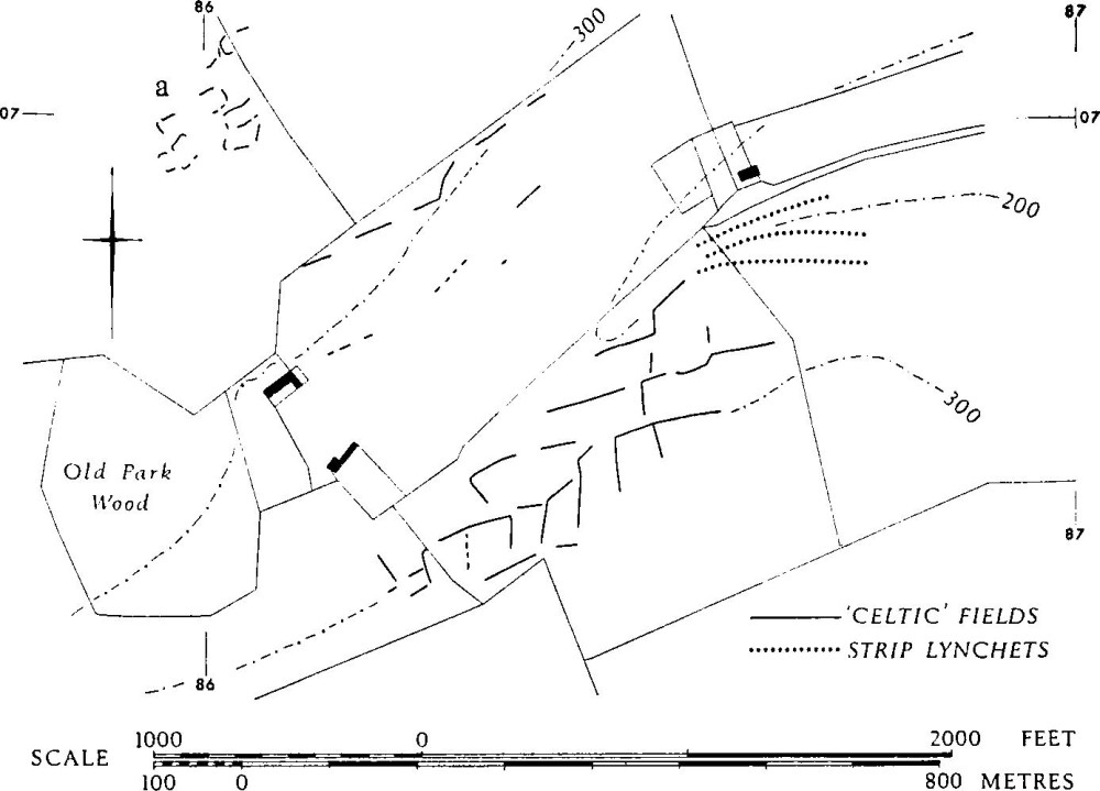
Group (60): Bryanston
For a probable settlement overlain by the parish boundary at the extreme E., and possibly associated with 'Celtic' fields, see Group (68).
Air photographs: CPE/UK 1934: 2166–9 and 1975: 2022–5 (N. of parish); 1934: 5164–8 (N.W. from Winterborne Stickland); 1934: 3167–70 (Stickland, Quarleston, Clenston).
Group (60): Bryanston and Durweston (Plate 88). 'Celtic' fields are traceable over 180 acres in the W. of Bryanston parish and over 220 acres of Durweston parish, chiefly in the E. They formerly continued in all directions, and blocks may have been connected within some 1,500 acres; links are suggested with Group (58), Shillingstone, on the N. and with Group (68), Blandford St. Mary, on the S. Most of the fields are on Chalk, though a few encroach on the Clay-with-flints which is widespread in the W. of Durweston. There is a settlement (a) in Old Park, Bryanston, ST 860070, and there are indications of another settlement ¾ mile E.N.E., at 870075 (Bryanston (10), p. 48).
The best preserved fields, with lynchets up to 14 ft. high, are on the S. side of the valley traversing Old Park, ⅓ m. S.E. of (a), (Plate 88). Even here there has been overploughing of lesser lynchets and almost complete destruction by strip lynchets Bryanston (9) in the E. (866068). Elsewhere, although there are some high lynchets, the pattern is greatly broken. Other strip fields, themselves much altered by subsequent cultivation, lie over, or have been cut into, 'Celtic' fields in a number of places, notably S.W. of Durweston, 856078–853082.
Settlement (a), about 4 acres in area, consists of a group of contiguous embanked, hollowed or platformed features on the summit of a spur falling gently E. Air photographs suggest that a track approached from W. and ran through the settlement. Occupation debris includes possibly Romano-British sherds, coarse pottery of Iron Age type, and wattle-marked daub. There is a tenuous link with the fields already noted, 550 yds. to the S.E.
Air photographs: F.21 58/RAF/1090: 69–70 (S); CPE/UK 1975: 2016–18 and 1934: 2162–5 (centre); 1944: 1320–3 (N.)
Group (61): Stourpaine, Iwerne Stepleton and Iwerne Courtney. 'Celtic' fields, all greatly disturbed, appear over some 150 acres of E. Stourpaine and can be just detected in the two parishes on the N.
All the fields are on Upper Chalk between 200 ft. and 500 ft. O.D. To the E. of Manor Farm, Stourpaine, ST 865094, and E. of Ash Farm, 868101 to 873100, in both instances on N.-facing valley-sides, the remains have been overlain by or integrated with strip and subsequent cultivation. E. of the second block the plough disturbance is generally later. On Stourpaine Down, around 880107, a broken pattern can be seen in a field called Horse Leys on the Tithe Map. (CPE/UK 1944: 3322–4). The only apparently complete fields here are 120 yds. long and about 35 yds. wide. S. of this, traces on France Down (876091) continue S. into Pimperne, again broken by strip and later cultivation (CPE/UK 1934: 2159–61).
In Iwerne Stepleton there are traces of fields N. of Everley Coppice, around 872118, and in Iwerne Courtney there are traces between Ranston Hill and Furzhill (873128–879129).
Air photographs: CPE/UK 1944: 2323–5.
Group (62): Hambledon Hill (Child Okeford, Hanford and Iwerne Courtney). There are traces of 'Celtic' fields, now totalling some 12 acres, but certainly indicative of a much greater former acreage, at a number of points on the Chalk of Hambledon Hill, between about 300 ft. and 600 ft. O.D. All the fields have been disturbed by subsequent ploughing and most of them are immediately adjacent to the hill-fort, Child Okeford (22). The least disturbed, at ST 847117, are ½ mile from the hill-fort and the same distance from the enclosure, probably of the Iron Age, Hanford (6); these are the only typical remains. They lie W. of a yew plantation, which partly encroaches upon them, between 300 ft. and 500 ft. O.D. on the S.-facing slope of a spur. There are only the faintest traces S. of Hanford (6).
The fields around the hill-fort have been almost destroyed by strip and later ploughing at S.W., 840122–842123, but one lynchet survives 8 ft. high. N. of this, around 842124, there are banks down the slope (23° to 25°) forming at least three fields, the smallest covering ½ acre and the largest 1¾ acre. The steep slope and the exposed position suggest that the lynchet formation might have been caused by stock rather than by cultivation. The fields below the N.W. limb of the hill-fort were probably laid out before the final enlargement of the defences, but they appear to have been adapted to continued cultivation. There are further traces E. of the N.E. entrance to the hill-fort.
Air photographs: CPE/UK 1944: 2327–9 and 3328–9; Cambridge University Collections, oblique, BZ 34, 47 and 49. Keiller Collection, verticals (N.M.R.).
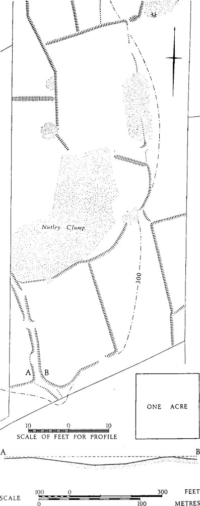
Group (65): North Down
Group (63): Burleston Down (Dewlish and Milborne St. Andrew). 'Celtic' fields are detectable over 150 acres of gently undulating ground, mostly arable, in Burleston, Dewlish and Milborne parishes between Burleston Down SY 776960, where they survived in a pasture field, 776965, 783966 and 791960; they formerly continued in all directions. To the W., faint traces survive on Basin Hill at 772960. All the fields were between about 250 ft. and 350 ft. O.D. on Upper Chalk. Even on the present pasture of Burleston Down the fields are much disturbed. Sides include two 17 yds. long; others are 35 yds. to 38 yds. One lynchet on the shoulder of a ridge is 20 ft. high.
Air photographs: CPE/UK 1934: 4111–5; 1974: 1357–8, 3357–8; 2018: 3088.
Group (64): Deverel Down and Chescombe (Milborne St. Andrew and Winterborne Whitechurch). Traces of 'Celtic' fields, mostly ploughed and in some cases disturbed by quarrying, occur over about 120 acres of undulating land, generally divided by N.-S. coombes, from a southern point at the extreme E. of Milborne parish, SY 823979, northwards across Deverel Down, almost to the road S. of Chescombe Farm, Winterborne Whitechurch, ST 826001—SY 833999. All the fields are on Upper Chalk, with patches of Clay-with-flints, between about 230 ft. and 400 ft. O.D. It is probable that they linked up with those on Roke and Bere Downs (Dorset II, Group (30)) and also continued in all directions. No certainly complete field survives, nor can the relationship of fields to the Deverel barrow, or the nature of a 'parcel' of enclosed strip divisions, be determined. Lynchets range from a recorded 1 ft. high on Deverel Down to 8 ft. S. of Chescombe Farm.
The Deverel barrow (Milborne (30)) lay near the corner of a 'Celtic' field and its remains are now some 50 ft. from the ploughed-down field edges. It is impossible to be sure of the chronological relationship. W. A. Miles noted in 1826 that the barrow stood on 'a sort of step to the plateau' (Deverel Barrow, 17), and his account, coupled with the present aspect, perhaps implies that the barrow was built in the corner of a field.
N. of Longthorns (825993), on ground falling gently N. above the shoulder of a shallow combe, air photographs show a block of six or seven parallel strips, bounded by ditches or furrows, within an incomplete enclosure about 170 yds. by 130 yds. cut by the parish boundary between Winterborne Whitechurch and Milborne (plan, p. 321; cf. Groups (38) (iii) and (66)).
A terrace-way or double-lynchet track, traceable for 3/5 mile roughly parallel with and just S. of the present road past Chescombe Farm, is earlier than enclosure and also earlier than an old road running S. from Chescombe, but its relationship to 'Celtic' field remains is uncertain because of disturbance.
Air photographs: CPE/UK 1934: 2117–8 and 5117–8; 1974: 2353–5.
Group (65): North Down (Winterborne Kingston. Plan, p. 342). Some 90 acres of 'Celtic' fields are detectable on and N.E. of North Down, between SY 853991 and ST 857001, on the summit and E. flank of a broad Chalk ridge close to 300 ft. O.D. They formerly extended in all directions. Only 16 acres around Nutley Clump (SY 855994) are now unploughed. Here, substantial earthworks, including curving scarps 4 ft. to 6 ft. high with a contemporary trackway, suggest the proximity of a settlement associated with the 'Celtic' fields. A few sherds of coarse pottery, probably Iron Age, were found.
Air photographs: CPE/UK 1934: 5122–3.
Group (66): Muston Down, and adjacent area (Winterborne Kingston and Winterborne Whitechurch). 'Celtic' fields, now almost levelled by ploughing, lay over some 180 acres of Muston Down in Winterborne Kingston, on gentle S.W. slopes between SY 862002, ST 872999 and the parish boundary to W. and N. They formerly continued in all directions except N., where, at least in their later phases, they were bounded by Combs Ditch (Winterborne Whitechurch (19)). Traces are detectable to N.W. along Combs Ditch, which may have been built along field edges on Whatcombe Down at 852021, accounting for its angular arrangement there. There are other outlying traces on Whatcombe Down, 842011 to 857016. A settlement is associated with long fields on Muston Down. All the fields are on Upper Chalk between about 250 ft. and 400 ft. O.D.
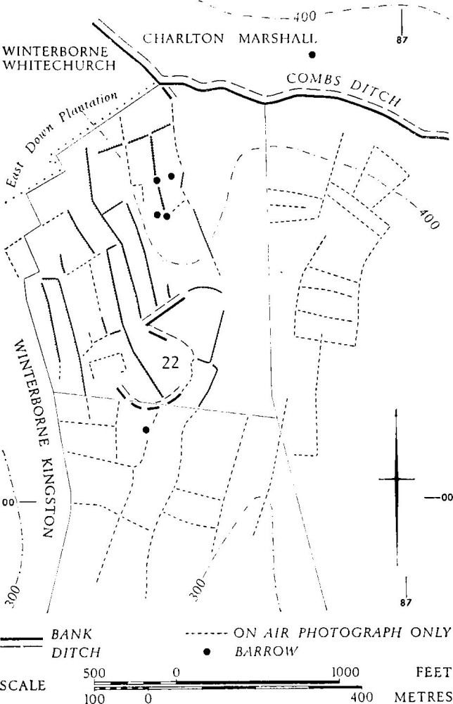
Group (66): Muston Down
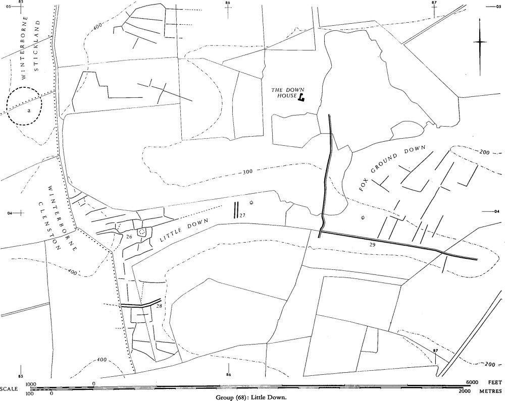
Group (68): Little Down
On Muston Down a straggling settlement, Winterborne Kingston (22), is associated with long 'Celtic' fields apparently superseding an older pattern. Iron Age 'A' coarse ware and samian pottery were found on the nearby fields. There is an indication of comparable long fields, up to 130 yds. long, on East Down, Winterborne Whitechurch, ½ mile N.W., at 861010. A line of apparent scarps and ditches, presumably marking a boundary, ran from the low bank, probably part of an early phase of Combs Ditch, projecting 40 yds. S.E. from its angle at 86540078, towards the N.E. of settlement (22). Of the long fields, W. of this boundary, four were 150 yds. to 160 yds. long and 30 yds. to 40 yds. wide. One was 230 yds. long and generally about 34 yds. across, but widening to 54 yds. at the N., where it probably incorporated one of the earlier fields, making a total of 1¾ acres. Barrows appear to lie at field angles or sides.
Air photographs: CPE/UK 1934: 1092–5 and 5122–5.
Group (67): Charlton Down and Thorncombe (Charlton Marshall and Spetisbury). 'Celtic' fields, now mostly destroyed on the ground and only recognisable as a pattern rather than as individual fields, can be detected in two main areas which were almost certainly linked: (i) on Charlton Down between Combs Ditch, ST 870008, and points E. of Bottom Plantation, 890008, and S.E. of Sparrowbush Farm, 880030; (ii) W.-E. across Thorncombe around a line from 862026 to 874029, W. of Sparrowbush Farm. All are on gently rolling Chalk, pierced by narrow valleys from the E., between about 180 ft. and 400 ft. O.D.
Area (i) is virtually continuous over some 250 acres, air photographs indicating squarish or oblong fields with original sides frequently 40 yds. to 60 yds. long (CPE/UK 1934: 1135–8 and 3125–7; F. 22 58/RAF/1212: 0046–8). Area (ii), totalling at least 80 acres, includes some unusual features (see also p. 321). To the S. of Red Barn Farm at 877027 is an incomplete but sharply rectangular pattern of fields with notably straight sides at least 130 yds. long and 25 yds. to 40 yds. wide (CPE/UK 1934: 1094–5). About ½ mile N.E. a block of parallel strip features (a) occurs, with probable ditches or furrows 10 yds. to 15 yds. apart, within an enclosed area having sides with rounded angles. Like the comparable blocks in Groups (38) and (64) it now is visible only on air photographs.
Air photographs: F.21 58/RAF/1090: 0083–4.
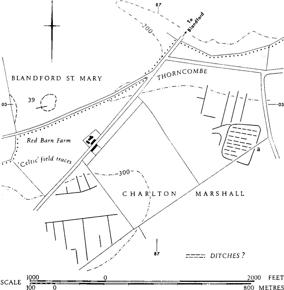
Group (67): Charlton Down and Thorncombe. Area (ii)
Group (68): Little Down (Blandford St. Mary. Plan, p. 344). 'Celtic' field remains, almost all broken by ploughing, occur over 100 acres of Little Down, Fox Ground Down and other areas in the N.W. of Blandford St. Mary parish, between 855032, 871036 and 854049. All are on Upper Chalk, partly capped by Clay-with-flints, between about 200 ft. and 400 ft. O.D. They formerly continued in all directions and they were almost certainly linked with fields of Group (60) to the N. A settlement, Blandford St. Mary (26), apparently Romano-British, is integrated with fields on Little Down, 856039. A probable settlement (a), a complex but roughly circular enclosed area of about 8 acres, suggestively Iron Age in form, is visible on air photographs ½ mile N.W. at 850045; it is cut by the parish boundary between Winterborne Clenston and Winterborne Stickland (Cambridge University Collections: obliques, AMN 100–2). The fields appear to be contemporary with cross-dykes and linear ditches.
The track approaching (26) from the W. is bounded by a ditched enclosure on the S., and, on the N., by a ditch which continues to form the boundary of another enclosure, a trapezoid of 1½ acres with subsidiary enclosures, which appears to be at the heart of the settlement. The track widens to about 30 ft. and then contracts to under 10 ft. before entering this enlcosure. Dyke (27) is apparently linked to the settlement by a straight ditch running towards its N. end. Dyke (28), S. of the settlement, was integrated with 'Celtic' fields of which some unploughed scarps survive to a height of about 6 ft.
Dyke (29), on Fox Ground Down, apparently bounded 'Celtic' fields N. of it. These were of regular form with long sides frequently extending to about 130 yds. There were also traces of fields immediately S.
Probable settlement (a) lies on the W. shoulder of a broad saddle in the N.-S. ridge, on ground sloping gently W. just above the 400 ft. contour, 150 yds. W. of the most westerly visible 'Celtic' fields.
About ¾ mile E. of Fox Ground Down, S.E. of Higher Buildings, 886038, at 200 ft. O.D. in an area otherwise without any such sign, air photographs taken by J. R. Boyden (ST 8803/1 and 2, N.M.R.) show a possible enclosure and track among traces of 'Celtic' fields which cover some 15 acres of W.-sloping ground.
Air photographs: CPE/UK 1934: 3163–6.