An Inventory of the Historical Monuments in Dorset, Volume 5, East. Originally published by Her Majesty's Stationery Office, London, 1975.
This free content was digitised by double rekeying. All rights reserved.
'Sixpenny Handley', in An Inventory of the Historical Monuments in Dorset, Volume 5, East(London, 1975), British History Online https://www.british-history.ac.uk/rchme/dorset/vol5/pp64-72 [accessed 30 April 2025].
'Sixpenny Handley', in An Inventory of the Historical Monuments in Dorset, Volume 5, East(London, 1975), British History Online, accessed April 30, 2025, https://www.british-history.ac.uk/rchme/dorset/vol5/pp64-72.
"Sixpenny Handley". An Inventory of the Historical Monuments in Dorset, Volume 5, East. (London, 1975), British History Online. Web. 30 April 2025. https://www.british-history.ac.uk/rchme/dorset/vol5/pp64-72.
In this section
18 SIXPENNY HANDLEY (9917)
(O.S. 6 ins., ST 91 NE, ST 91 SE, SU 01 NW)
This parish, roughly quadrilateral in outline and covering over 6,000 acres, spans the upper reaches of three valleys which drain southwards, that in the E. to the R. Allen, the others to the Gussage Brook. The whole area is on Chalk, the land rising generally north-wards from some 200 ft. above O.D. in the S. to 497 ft. on the county boundary in the N., where extensive woodlands, part of Cranborne Chase, coincide to some extent with patches of Clay-with-flints above the Chalk.
Sexpena and Hanlega were the names of two distinct hundreds. Eventually, probably in the 14th century, they were united as the Hundred of Sexpenne et Henle (Hutchins III, 534), but the use of both words in the name of the parish is modern; until quite recently it was called Handley. The parish was formed in the 19th century by the amalgamation of two chapelries, Handley and Gussage St. Andrew, previously parts of Iwerne Minster parish (Dorset IV, 36); Handley, however, had been a parish until late in the 13th century (Hutchins III, 544). The ecclesiastical division reflects the pattern of settlement. The E. part of the parish has always been centred economically and tenurially on Handley village, a long-street settlement on the N.E. side of the eastern dry valley, Until the end of the 18th century it had no outlying settlements; Upwood Farm was established c. 1790 although the present buildings are modern; Deanland and Newtown are 18th and 19th-century encroachments on the woodland. The open fields were finally enclosed in 1797 (Award, D.C.R.O.).
The history of settlement in the W. part of the parish is more complicated. Minchington and Gussage St. Andrew were early settlements in the valley of the Gussage Brook, each with an associated strip of land extending N. into the woodland; to a large extent the boundaries of these strips are still preserved in the form of continuous hedgerows. Within Gussage St. Andrew two later settlements appear to have grown up: Woodcutts on the edge of the woodland was in existence by 1244; Dean, in a small tributary valley, was in existence by 1278 (Fägersten, 25).
The parish contains several houses of the 17th century and earlier, also two important archaeological sites excavated by General Pitt-Rivers in the 19th century. Handley village was destroyed by fire in 1892 and contains very few Monuments.
Ecclesiastical
(1) The Parish Church of St. Mary, on a knoll at the N.W. end of Handley village, has walls of banded rubble and flint with ashlar dressings; the roofs are tiled. An image of Christ-in-Majesty, the font, and a capital reused as a stoup in the porch indicate a 12th-century building, but nothing else survives of that date. The Chancel and the South Porch are of 14th-century origin. A north aisle was built in 1832 (Act Book, Sarum Dioc. Regy.). In 1877 the Nave, North Aisle and West Tower were entirely rebuilt, a South Aisle was built, and the 14th-century porch was removed from its former position and re-erected (Faculty, Sarum Dioc. Regy.).
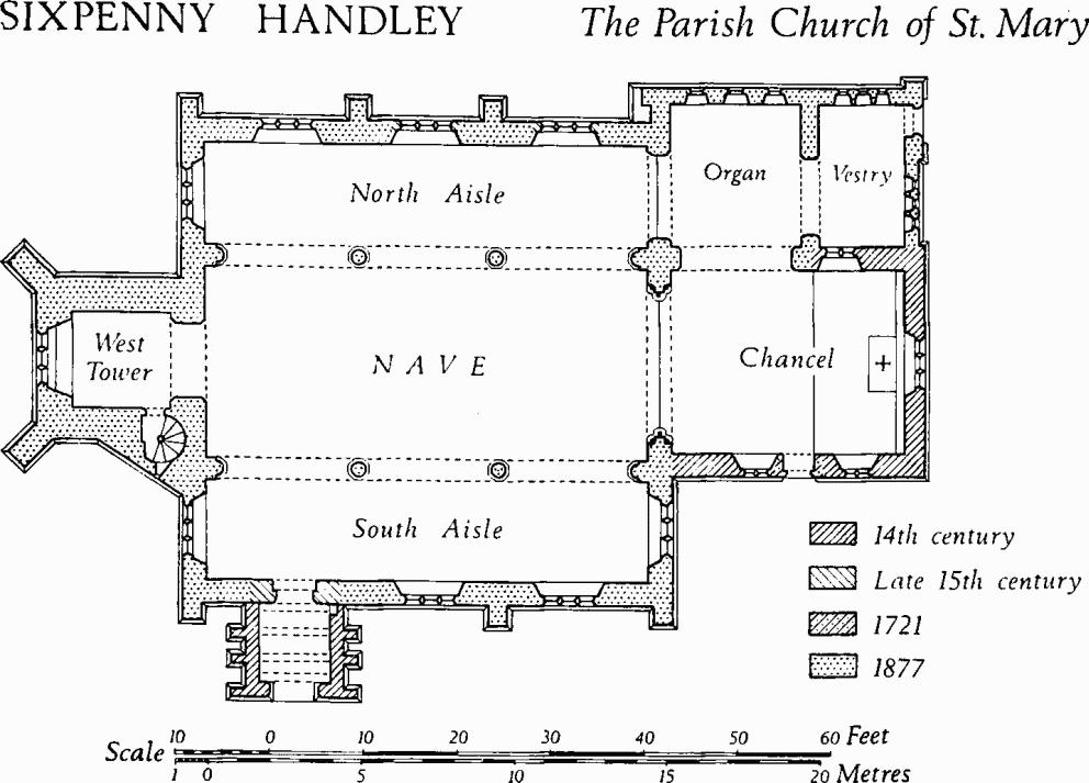
Sixpenny Handley, the Parish Church of St. Mary
Architectural Description—The Chancel has an early 14th-century E. window of three trefoil ogee-headed lights with curvilinear tracery in a two-centred head. The N. and S. walls have respectively one and two early 14th-century windows, each of two trefoil ogee-headed lights with a quatrefoil in a two-centred head. The S. doorway in the chancel is probably of 1721 and has a chamfered semicircular head; the date appears above it. The chancel-arch is modern. Reset high in the E. wall of the organ chamber is a window similar to the side windows of the chancel and no doubt moved from the N. wall.
The North Aisle has two reset and partly restored windows, probably of late 15th-century origin; they are of three trefoil-headed lights in a square head; the labels have male, female and dog head-stops.
The West Tower incorporates old material; it is of three stages with a moulded plinth; the embattled parapet has four mediaeval gargoyles. The belfry has, in each wall, a 15th-century window of two trefoil-headed lights with a blind quatrefoil in a two-centred head with a label.
The reset South Porch (Plate 64) has an outer archway with a two-centred head of two chamfered orders. The barrel-vaulted stone roof is divided into three bays by broad, two-centred, chamfered ribs which die into the side walls; they are supported externally by buttresses which continue as raised bands on the weathered stone roof. On the N., the reset doorway to the 19th-century S. aisle is of late 15th-century origin and has moulded jambs and a four-centred head with sunk spandrels in a square surround.
Fittings—Brass: In chancel floor, to Ureth, wife of Richard South of Lockerby, 1629, inscription plate, 4½ ins. by 15 ins. Chest: of oak, with panelled sides and chip-carving on front, 17th century. Coffin-stools: two, with turned legs, 17th century. Font: of Purbeck marble, with square bowl with four round-headed panels in each side, cylindrical stem and three angle shafts (one missing), 12th century; oak font-cover, octagonal, with enriched framework and turned knobs, 17th century. Image: (Plate 9) reset in N. aisle, on N. wall, rectangular stone with moulded vesica-piscis enclosing seated figure of Christ-inMajesty, surface much defaced, probably 12th century. Monuments: In S. aisle, reset at E. end, (1) of John Alie, 1579, Dorothy (Ashey) his wife, 1577, Henry their son, 1631 and Elizabeth (Constantine), Henry's wife, 1630, canopied table-tomb (Plate 12) with entablature supported on Ionic columns and pilasters; between pilasters, an arched recess with carved spandrels and intrados. Reset in W. tower, (2) of Richard Withers, 1825, tablet by Osmund of Sarum; loose on window-sill, (3) stone fragment of inscription to wife of Thomas Cook, 1669. Niche: In gable of S. porch, small projecting hood, perhaps mediaeval. Stoup: In recess in S. porch, hollowed-out 12th-century scallop capital. Sundial: On S. wall of chancel, scratch-dial. Miscellanea: Loose in W. tower, fragments of stone cartouche-of-arms of Alie, 17th century.
(2) St. Andrew's Church, Gussage St. Andrew (97611425), some 2¼ miles S.W. of (1), has flint walls with ashlar dressings, in part rendered, and a tiled roof. The Nave, of 12th-century origin, has 13th-century wall-paintings (Plates 7, 24). The Chancel dates from late in the 13th century. Although small, the building has good 12th and 13th-century features and is of considerable interest.
Architectural Description—The gabled E. wall of the Chancel has two restored 13th-century lancet windows; the N.E. and S.E. corners have ashlar buttresses of two weathered stages. The eastern window in the N. wall is of 13th-century origin, restored in 1857. In the S. wall the easternmost window is of the late 13th century, with two trefoil-headed lights and a quatrefoil spandrel light under a two-centred head with a moulded label; the two-centred hollow-chamfered rear-arch also has a moulded label. The jamb and sill contain an original piscina and recess. The adjacent S. doorway, contemporary with the window, has a sunk-chamfered two-centred head and continuous jambs with roll-moulded stops; the rear-arch is segmental-pointed and chamfered.
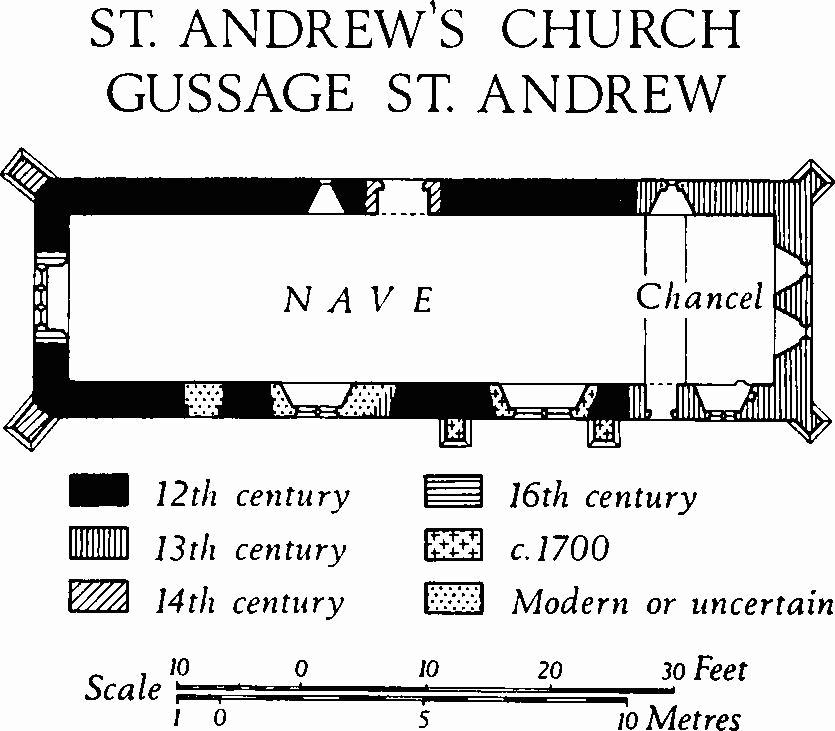
St. Andrew's Church, Gussage St. Andrew
The Nave has a 14th-century N. doorway with a chamfered two-centred head and chamfered jambs. Adjacent on the W. is a round-headed 12th-century window with wide splays and a semicircular rear-arch. The S. wall of the nave has two brick buttresses of c. 1700 flanking a window of two square-headed lights, probably of the same date. Further W. is a window of 1857 with two trefoil-headed lights, and immediately E. of this are the chamfered jambs of a blocked doorway, perhaps 13th century. Still further W. is a blocked 12th-century doorway with an unchamfered round head and a semicircular rear-arch.
The W. window, of three trefoil-headed lights in a square surround with a chamfered segmental rear-arch, is of the early 16th century. The N.W. and S.W. corners of the nave have 14th-century diagonal buttresses of one weathered stage.
The nave Roof is of the 15th century and has five rough tie-beam trusses with chamfered and cambered ties and curved struts; the trusses rest on chamfered wall-plates.
Fittings—Chandelier: of brass, with three tiers of scrolled brackets and ball pendant, early 18th century. Communion Rails: of oak with spirally turned balusters, early 18th century, restored. Communion Table: of oak, with turned legs and enriched rails, 17th century. Floor-slabs: In chancel, beneath communion table, (1) of William Williams, Purbeck marble slab (Plate 11) depicting coffin surrounded by emblems of mortality and inscribed 'Gulielmus Williams de Woodcotts Generos. extremum suum diem clausit Novemb. ye 17th 1725, Aged 100'. In nave, (2) of John Lush, 1722, and Mary his wife, Purbeck marble slab with symbols of mortality. Font: of Purbeck stone, with plain tub-shaped bowl and moulded stem, 12th century; spurred octagonal stone base, mediaeval. Glass: In central S. window, roundel with crown, 15th century.
Niche and Piscina: In jamb of E. window of S. wall, rectangular niche with chamfered trefoil head; in sill of same window, corbelled piscina with eight-lobed basin, moulded underneath; both late 13th century.
Plate: includes cup of usual Elizabethan form with donor's inscription of Henry Alye, late 16th or early 17th century; also stand-paten with maker's mark VG. Pulpit: of oak, with four panelled sides with chip-carving, late 17th century. Royal Arms: crudely painted on panel, of George III, after 1801.
Tables of Creed etc.: Reset on W. wall, two square-headed wooden panels with moulded surrounds, with Lord's Prayer, Creed and Decalogue in gilt lettering, and 'Benjamin Biles, chapel-warden, 1811'. Wall-paintings: In nave, on N. wall (Plate 24), ashlar ruling probably late 12th century; superimposed figures late 13th century; black-letter texts, illegible, probably 17th century.
Secular
Sixpenny Handley
(3) Handley House (99631723), recently demolished, was of two storeys with attics and had walls of chequered ashlar and flint-work, partly rendered, and tile-covered roofs. The kitchens were of 17th-century origin; the main range, with a class-T plan, was added on the W. of the kitchen range early in the 18th century; further extensions were built in the late 18th and 19th centuries.
The S. front of the main range was approximately symmetrical and of five bays, with french windows in the lower storey and with sashed windows above. Small wings projecting at each end of the S. front were of the 19th century. The E. elevation of the 17th-century kitchen range was of knapped flint with ashlar dressings. The gabled W. end of the main range had no openings. The N. front was masked by 19th-century extensions which composed a symmetrical façade of gabled bays, each with a round-headed window, flanking a central bay with the main doorway under a pillared porch.
Inside, some of the rooms had fielded panelling. The stairs, situated in one of the 19th-century extensions on the N. of the main range, were of the first half of the 18th century and evidently had been brought from elsewhere. They had cut strings, fluted Tuscan-column newel-posts, three vase-andcolumn balusters to each tread, and moulded and swept handrails which ended in a first-shaped scroll (Dorset III, lxii). The staircase dado had fielded panelling and a moulded capping. Other 18th-century fittings in the house included a small oak chimneypiece with a carved floral swag and pendants.
(4) Manor Farm (99901662), house, of two storeys with attics, has brick walls and tiled roofs. It dates from the middle of the 18th century and has a later 18th-century extension on the N. The E. front of the original range is symmetrical and of three bays, with a central doorway under a small porch with slender Tuscan columns, and with plain sashed windows in both storeys. The W. front has similar features, but no porch. The plan is of class T.
Adjacent to the farmhouse on the N. is an 18th-century Granary, rectangular on plan, with brick walls on staddle-stones and with a tiled roof. A Barn with a thatched roof, some 50 yds. N.W. of the house, now gone, appeared to be largely of the 18th century, but it incorporated in ashlar and squared rubble wall with weathered ashlar buttresses, perhaps of 17th-century origin. A scratching of 1739 was noted.
(5) Frogmore Farm (99891688), house, of two storeys with brick walls and a tiled roof, was built probably in 1712. Originally the S.E. front was approximately symmetrical and of three bays, with a central doorway and with square-headed casement windows in both storeys. Late in the 18th century a S.E. wing was added at the S.W. end of the original range, and in more recent times a further addition was built in the re-entrant angle between the two ranges. A date-stone inscribed WH 1712 in the S.E. end wall of the late 18th-century wing, now hidden, probably refers to the building of the original range; it may once have been set above the central doorway. Inside, the plan is of class T; one room has a chamfered beam with shaped stops.
(6) Town Farm (00011717), house, of two storeys with attics, dates from early in the 19th century and has walls partly of banded flint and brickwork and partly tile-hung; the roofs are tiled. The E. front is symmetrical and of three bays, with segmental-headed sashed windows in each main storey and with a round-headed central doorway with a fanlight. A timber porch with trellised sides and an opening with a two-centred head is of the mid 19th century. Inside, the house has a class-U plan.
(7) Cottage (00141736), of one storey with attics, has cob walls with some timber reinforcement, on a plinth of flint and brick, and a thatched roof; it is of c. 1800.
Gussage St. Andrew and Minchington
(8) Chapel Farm (97591428), house, of two storeys with walls partly of knapped flint, partly of banded brick and flint and partly of brick with ashlar dressings, dates from early in the 17th century. The roofs are tile-covered. The original building had an L-shaped plan with the principal front on the N.W. and with a S.E. wing at the back. In the 18th century the N.W. range was extended on the N.E., more than doubling its length.
The original N.W. front is of flint and squared stone blocks in courses alternating with double courses of brick; it is approximately symmetrical and of three bays, with a central doorway flanked in the lower storey by square-headed three-light casement windows with moulded stone surrounds and mullions, and with three-light casement windows with timber surrounds in the upper storey; at an intermediate level a stone two-light casement window opens over the doorway. The N.W. front of the 18th-century extension is also symmetrical and of three bays, but here the façade is of brick with ashlar quoins and the principal windows are sashed. In the rear elevation, to S.E., the outside wall of the original N.W. range is of neatly coursed knapped flint with squared rubble quoins. The S.E. wing is partly of flint and rubble and partly of knapped flint banded with brick; the quoins are of squared rubble. Inside, the house has been greatly altered and the original plan is lost. The roofs have collared tie-beam trusses, those of the 17th century range being stouter than those in the N.E. extension.
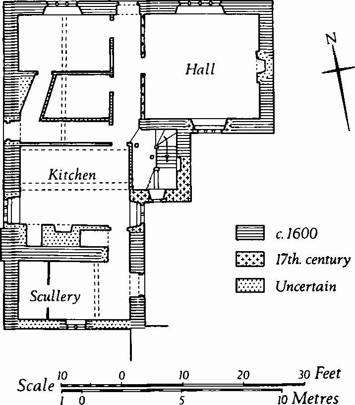
(9) Lower Farm, Minchington (97021455), house, of two storeys with attics, has walls of flint and rubble, in part rendered, with ashlar quoins and dressings; it dates probably from c. 1600 and retains interesting fittings.
The N. front is of three bays, with a stone doorway with a shallow four-centred head, flanked by square-headed casement windows with chamfered stone surrounds and labels; immediately over the door-head is a small stone window of one light; the upper storey has plain wood-framed casements. The W. and S. elevations have no notable features. In the E. elevation (Plate 30) a stone doorway with a shallow four-centred head gives access to the scullery, a single-storeyed structure with a lean-to roof on the S. of the kitchen chimneybreast. A vertical joint in the E. wall of the stair tower indicates that the tower was enlarged later in the 17th century.
Inside, the hall is divided from the adjacent through-passage by a 17th-century panelled oak partition brought recently from elsewhere; its two original doorways have been closed with later panelling and a central opening has been formed between them. On the W. of the through-passage is an original plankand-muntin partition with two doorways side-by-side near the centre (that on the N. subsequently blocked and replaced by another opening further N.). The stairs to the first floor are of the later 17th century and have a moulded handrail and turned balusters; above, the stairs are of c. 1600 and have solid oak treads radiating from a circular wooden newel-post. The kitchen ceiling has a deep stop-chamfered beam, and similar beams span the service rooms on the W. of the through-passage. Some first-floor rooms retain plank-and-muntin partitions; stud partitions in the attic have doorways with chamfered four-centred heads.
Lower Farm
(10) Cottage (96991460), of one storey with an attic, with cob walls and a thatched roof, is of the first half of the 18th century. The plan is of class S.
(11) Cottage (96971460), of one storey with an attic, with cob walls and a thatched roof, is probably of the 17th century. Original attic dormer windows have small square-headed lights with ovolo-moulded timber surrounds. The plan is of class S.
(12) Minchington Farm (96171495), house, of two storeys, has walls of squared rubble and flint, with brick and stone dressings, and a thatched roof; it is of the late 16th or early 17th century. The plan is of class T, with an original N. wing, centrally placed, at right-angles to the main S. range. The three-bay S. front retains in the lower storey an original casement window of three square-headed lights with moulded stone surrounds; a similar two-light window occurs in the upper storey; the other openings are modern. Inside, the throughpassage between the two main ground-floor rooms, flanked by moulded plank-and-muntin partitions, is occupied by a secondary staircase. The E. ground-floor room has an open fireplace with chamfered stone jambs and a chamfered and cambered oak bressummer. The ground-floor room in the N. wing has a large chamfered beam.
(13) Dean Farm (97841519), house, of one storey with dormer-windowed attics, has cob walls and a thatched roof; it is of the late 18th century.
Woodcutts
(14) Manor Farm (96941693), house, of two storeys with walls of chequered flint and stone and with tile-covered roofs, dates from early in the 18th century (Plate 30). The S.E. front is symmetrical and of five bays, with a central doorway and square-headed sashed windows with plain keystones. The gabled N.E. and S.W. end walls have projecting chimneystacks capped by diagonally set flues. Inside, the plan is of class T. The staircase has cut strings and turned balusters.
(15) Cottages (97101701), two adjacent, of two storeys with walls of banded brickwork and flint, and with tiled roofs, are of the 18th century, but they incorporate a stone doorway and other masonry of 17th-century date. Reset in the S. front are 20 small monolithic round-headed niches of unknown origin. On O.S. maps the site is named 'Old Manor House'.
(16) Champs Farm (96711681), house, demolished in 1960, was single-storeyed with attics and had original walls of knapped flint with dressings of squared rubble and ashlar. Later repairs and refacings were of banded brickwork and flint; the roofs were thatched. The house, probably of early 16th-century date, was in ruins at the time of demolition. Originally, the building comprised a hall with an open hearth, with smaller rooms at each end.
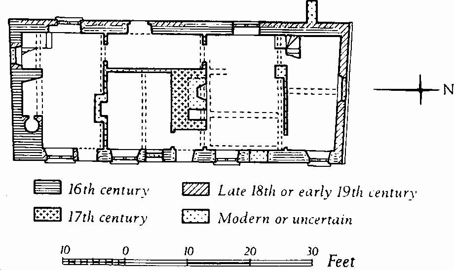
Champs Farm
The range was of four bays and the roof was supported on upper cruck-trusses. In the S. bay, evidently the kitchen, the open fireplace had splayed ashlar jambs and a chamfered oak bressummer with a raised centre; a secondary oven had been formed in the E. jamb. Above the fireplace opening was a stout stop-chamfered wall-plate for the original attic floor. The 19th-century stairs on the W. of the chimneybreast probably took the place of an original winding staircase. The doorway in the E. wall of the kitchen had a bead-moulded timber frame, probably of the 18th century. The adjacent room had, on the E., a blocked original doorway of ashlar with a chamfered four-centred head and chamfered jambs. Nearly opposite, on the W., were remains of another early doorway with one ashlar jamb.
The cruck-truss between the second and third bays was smoke-blackened and had arch-braces, indicating that these bays originally composed a hall with an open hearth near the centre. The crucks were chamfered and at the apex were pegged to an angled yoke. Early in the 17th century the open hearth had been replaced by a large fireplace with a stout timber bressummer and with a flint flue terminating in a brick chimney-stack; at the same time the hall was chambered over. The attic floor on the N. of the chimneybreast was supported on two deep stop-chamfered beams and corresponding E., N. and S. wall-plates. Doubtless the part of the former hall which lay to the S. of the chimneybreast also was chambered over at this time.
The N. bay had been rebuilt late in the 18th or early in the 19th century and its original form is unknown; here the attic floor rested on a roughly chamfered beam.
Mediaeval and Later Earthworks
(17) Settlement Remains (963148), formerly part of Minchington, lie S.E. of (12) on both sides of the valley of the Gussage Brook and consist of fragmentary rectangular closes bounded by low banks and scarps. Most closes have platforms representing former buildings, those on the N. side of the valley being particularly well marked. By the early 19th century the sites on the N. had been deserted, but those on the S. continued to be inhabited (O.S., 1811).
(18) Enclosure (01201630), on the S. slope of Handley Hill, 360 ft. above O.D., is almost square and covers ¼ acre. It is bounded by a bank, nowhere more than 1½ ft. high and 8 ft. wide, with an external ditch up to 1 ft. deep. A gap 6 ft. wide occurs at the centre of the N.W. side. The interior is featureless. In 1893 Pitt-Rivers excavated and interpreted the site as of prehistoric and Romano-British origin, but pottery recovered by Pitt-Rivers has been re-examined and is now found to be of the 12th century; it thus appears that the site is mediaeval, but see also (22). (Pitt-Rivers, Excavations in Cranborne Chase, IV (1898), 46–57; W.A.M., XLVII (1936), 409; P.P.S., II, n.s. (1936), 229–30.)
Roman and Prehistoric
(19) Iron Age and Romano-British Settlement on Woodcutts Common (963181), associated with tracks and 'Celtic' fields (Group (83), p. 118), covers about 4 acres and was probably a single farmstead. It lies in the N. of the parish, just under 500 ft. above O.D., on a gentle S.E. slope of the Chalk, here in part covered with Clay-with-flints. The site was dug into by J. H. Austen in 1863 and it was excavated by General PittRivers in 1884–5 (Pitt-Rivers, Excavations I (1887), 7–239; Arch. J., XXIV (1867), 168–9). The data obtained by Pitt-Rivers have been reinterpreted by C. F. C. Hawkes (plans opp. p. 69) in particular to reveal a sequence of development on the site (Arch. J., CIV (1947), 42–8; but see also P.P.S., XXIV (1958), 101–19 and J.R.S., LIV (1964), 62). The present appearance of the site (Plate 63) is due to Pitt-Rivers, who reconstituted much of it to conform with his own discoveries, rather than with its form before excavation.
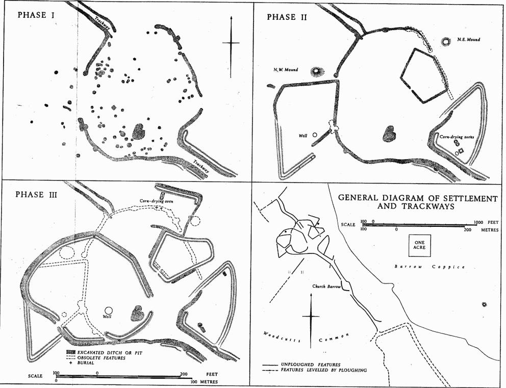
Sixpenny Handley. (19) Iron Age and Romano-British Settlement on Woodcutts Common.
Before excavation, the visible remains comprised a roughly circular enclosure, about 300 ft. across with a gap at the S.E., defined by a low bank with an external ditch, together some 16 ft. across. Inside the enclosure was a mound 20 ft. across and 2 ft. high, also two roughly rectangular depressions in the N. part and two circular hollows in the S. part. Outside the ditch to the S.W., a slight ditch and bank enclosed a triangle with sides of about 100 ft. Two trackways, each about 20 ft. wide and flanked by slight ditches and outer banks, ran towards the main enclosure from N.W. and S.E. Beyond them on the E. side were two other enclosures, a quadrilateral 150 ft. by 100 ft. on the E. and a triangle 170 ft. by 100 ft. on the S.E., both defined by low banks. To the N. of the E. enclosure was a slight E.–W. bank and ditch and an isolated mound 22 ft. across and 1 ft. high. The S.E. trackway could be traced for 385 ft., as far as a semicircular embanked depression 93 ft. to 130 ft. across, known as Church Barrow, and beyond it for a further 400 ft. Short lengths of ditch branched N.E. and S.W. for 50 ft. from the trackway ditches, 180 ft. N.W. of Church Barrow. The N.W. trackway could be followed for some 300 ft.
In 1863 J. H. Austen dug into the N.W. mound, the E. depression in the main enclosure, and into one of the circular hollows. The excavations of 1884–5 were more thorough. The main enclosure and the two enclosures on the E. were totally excavated and all ditches encountered were followed, including those of the two trackways; the N.W. mound was removed, the N.E. mound and Church Barrow were sectioned, and two wells (represented by the circular hollows) were cleared to depths of 136 ft. and 188 ft. The triangular enclosure to the S.W. was the only principal feature not investigated. On completion of the excavations, the earth cleared from the ditch of the main enclosure was left to heighten the bank.
The excavations showed that the site initially consisted of a roughly circular enclosure, some 300 ft. in diameter, defined by a ditch up to 18 ft. wide and 6 ft. deep (Phase I in accompanying plans). Trackways led into it, and there appear to have been wide gaps on E., W., and N. There was probably a house in the W. part of the interior, and numerous chalk-cut pits, up to 10 ft. across and up to 9 ft. deep, were found. Phase II was characterised by the addition on the W. of a kite-shaped enclosure measuring about 280 ft. by 150 ft., and two smaller enclosures on the E., the southern containing two corn-drying ovens. The mounds outside the enclosures on N.E. and N.W. probably belong to this phase; the north-western was perhaps a barrow, since a cremation in a Roman pot was found near its foot. In phase III, most of the earlier ditches and pits had been filled and the roughly circular enclosure (seen before excavation began) had been added on the W. This enclosure contained a well 4 ft. in diameter and 188 ft. deep, and probably also a building, as indicated by roofing slabs and painted plaster from a wattled wall. The two E. enclosures of phase II were retained, but the more northerly was enlarged to the E. and another, enclosing a corn-drying oven, was added on the N. Church Barrow was erected at this time over the ditches of the S. trackway.
The three phases appear to have begun, respectively, in the early 1st century A.D., the late 2nd century and the early 4th century, but occupation was apparently continuous. Some Iron Age 'B' pottery, a La Tène I brooch, much Durotrigian pottery and four Durotrigian coins were found. The first phase probably continued until about 180, as indicated by samian and coarse pottery and seven coins; most of the 84 brooches apparently also belong to the 1st century A.D. A hoard of 36 coins from 74 B.C. to c. A.D. 180 or 270 (fn. 1) was found, with remains of a bronze-mounted casket, near a hearth in the E. depression. No coins of the first half of the 3rd century were found, but there were 130 coins for the period 253 to 296. Coins and New Forest pottery indicate occupation until c. 360. Finds of bronze and iron were numerous, including rings, pins, tweezers, spoons, harness, knives, ploughshare-tips and other tools. There were spindle whorls, beads, bracelets and handles of shale, as well as lathe-cores and unworked pieces of the same material. Stone objects included whetstones, querns and mortars. Burials of thirteen adults, a child killed by a sword-cut and of twenty-two infants were found in pits, ditches and in a corn-drying oven; scattered human bones, presumably from disturbed burials, were common. Bones of ox, sheep and pig were the most numerous, but remains of horses, dogs, deer and other wild animals and of birds were also identified. In one pit some wheat grains were found, and chestnut was distinguished among more common woods. The finds are in the Pitt-Rivers Museum at Farnham, and in D.C.M.
(20) Romano-British Occupation Site (98311708), noted in 1951 in the W. side of Humby's Stock Coppice, was indicated by coarse pottery, a bronze bracelet, and 11 coins ranging from Antoninus Pius to the late 4th century; copper slag was also found (Dorset Procs., 73 (1951), 104–5). An Enclosure (982168) linked with boundary ditches and a track is revealed by an air photograph (C.U.A.P., BCV 86) in the arable immediately W. and S. of the coppice (Plate 62). It is sub-rectangular, about 280 ft. by 240 ft., and it has an entrance on the S.E. Numerous storage pits, nearly all inside the enclosure except for a few on the W., suggest an Iron-Age origin. From the entrance a narrow passage flanked by side-ditches extends S.E. for about 120 ft. The ditches then curve away, one to S. and S.E., the other to N.E. and then N.W. The second ditch follows a sinuous course and at 98311686 curves to accommodate a small, roughly circular enclosure about 100 ft. across, possibly with storage-pits inside it. Beyond this the ditch forms one side of a track which leads N.W. This ditch appears to have replaced earlier alignments just outside the entrance passage.
(21) Romano-British Settlement, S.W. of Oakley Farm (008181), lies on the gentle N. slope of a spur at about 340 ft. above O.D. It has for long been levelled by ploughing, but it is visible on air photographs (C.U.A.P., RC 8 V223, WX 65, 66) as part of what appears to be an irregular ditched enclosure with occupation areas inside it, associated with 'Celtic' fields (Group (85), p. 118). Pottery, including a sherd of decorated samian, has been found on the site.
(22) Roman Occupation Debris, including a denarius of Trajan, was found in and under the bank of a mediaeval enclosure on Handley Hill (01201630). (Pitt-Rivers, Excavations IV (1898), 46–51; P.P.S., II (1936), 229–30.)
(23) Roman Building and Occupation Debris, found in 1868 'in a field called Oak Hill' near Minchington, included sandstone wall footings, wall plaster painted with red and green borders, some small red and white tesserae, large stone roofing slabs, and coins (Hutchins III, 547).
A Roman coin hoard of 693 denarii from Mark Anthony to Septimius Severus, buried soon after 195, was found in 1877 in a pot on Upward Farm, near Deanland (992183); 440 surviving coins are now in D.C.M. (Pitt-Rivers, Excavations III (1892), 279; Numismatic Chronicle, 6th Ser., X (1950), 311–15; Dorset Procs., 73 (1951), 115.)
For Romano-British burials in barrows, see (29), (31), (40).
(24) Enclosure, probably Iron Age and/or Romano-British (Plate 63), adjoins the W. boundary of the parish, ½ mile N.N.E. of Farnham (961160); it lies on the E. slope of a spur, between 325 ft. and the summit at 360 ft. above O.D. It comprises a roughly circular area of some 12 acres defined by a ditch, but the whole has been disturbed by quarrying and severely mutilated by ploughing. The S. half is barely visible on the ground, but air photographs (N.M.R., ST 9616/6/189) confirm its existence and show clear indications of former occupation within the enclosure. On the N. side, where it is best preserved, the ditch measures some 21 ft. across and 3 ft. deep and there are snote idictions of an inner bank. There are gaps in the earth- work on the N.E. and the N.W. sides; a hollow way leads downhill S.E. from the former and air photographs show hollow ways or ditches approaching the latter, but it is not certain that either gap represents an original entrance. The site has been identified with Totenberg, which occurs in a Handley charter of 956 (see (25)).
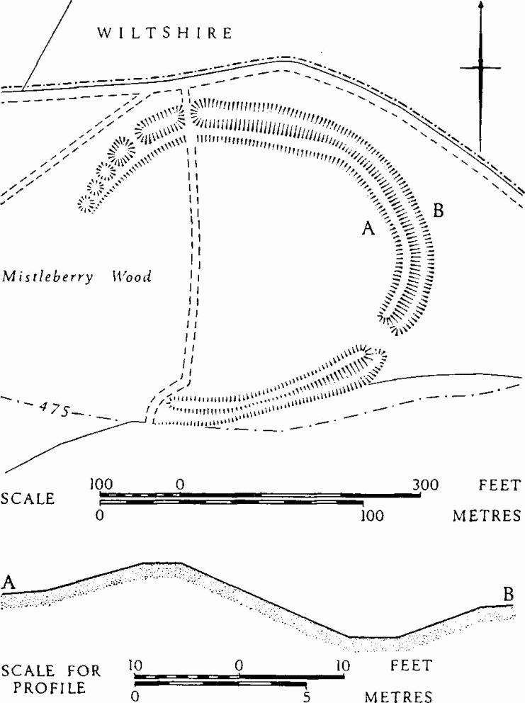
(25) Unfinished Hill-fort, in Mistleberry Wood in the extreme N. of the parish, occupies a weak defensive position on the S. slope of a spur between 475 ft. and 500 ft. above O.D. (996195). It lies within an area of Clay-with-flints and is obscured by trees and bushes. The defences, which comprise a bank with an external ditch, have been left unfinished on the S.W. side, but if complete would enclose an oval of just over 2 acres. At its best the bank is 24 ft. across and 4 ft. high and the ditch is of similar dimensions. The unfinished nature of the earthwork is clearest on the N.W. where the bank gradually diminishes in height and the ditch becomes a series of shallow pits. There is an original entrance on the S.E. side. The site is probably to be identified with Mealeburg, which occurs in a charter of 956 relating to Handley (Dorset Procs., 58 (1936), 118).
Wiltshire
(26) Enclosure, W. of Woodcutts Common in Brookes Coppice (961177), lies at 475 ft. above O.D. on a gentle S.E. slope in an area of Clay-with-flints. It is just over I acre in internal area and roughly circular on plan, with an entrance on the E. It is defined by a ditch up to 18 ft. wide and 2 ft. deep and there are slight traces of an outer bank on the N. side. The N.E. side of the enclosure, which probably is of Iron Age or Romano-British date, has now been levelled by ploughing.
(27) Bronze Age Ditch, known as the Angle Ditch and probably part of an occupation site, lies on the summit of Handley Down (01171730), some 200 ft. W. of Wor Barrow (29). Not visible as a surface feature, it was discovered by bosing and was excavated by General Pitt-Rivers. It lies in an area of 'Celtic' fields (Group (85), p. 118), now heavily ploughed, and appears to be integrated with their pattern. The ditch, 6½ ft. deep, 7½ ft. wide at the top and 1 ft. wide at the bottom, followed an irregular line for 165 ft. from S.W. to N.E., then turned at right-angles towards the S.E. and continued for a further 60 ft. Finds from the lower filling of the ditch indicate a date in the later Bronze Age; they include parts of a looped palstave and of a class-II razor, a bronze awl, a sandstone grain-rubber, a complete barrel urn and fragments of others, and a fragment of a globular urn. Possibly the ditch formed part of a roughly rectangular enclosure with broad gaps in its sides, like that on Martin Down, Hants., also excavated by Pitt-Rivers and found to be of comparable date (Excavations IV (1898), 185–214). That the Angle Ditch had already been obscured by ploughing in the Roman period is clear from the quantity of later pottery, especially Romano-British wares, found in its upper filling and as a surface scatter around it.
Pitt-Rivers's excavation also revealed a shallow ditch, 3 ft. wide and 1½ ft. deep, which ran for over 450 ft. from N.N.W. to S.S.E. across the site and was apparently cut by the Angle Ditch. Its position and its apparent relationship with the 'Celtic' fields immediately to the W. suggest that it may have served to separate those fields from an uncultivated area surrounding Wor Barrow, rather than as a drain, as suggested by Pitt-Rivers. Finds from the excavation are in the Pitt-Rivers Museum at Farnham. (Pitt-Rivers, Excavations IV (1898), 58–61, 102–113; Dorset Procs., 46 (1925), 92–3; Arch. J., CXIX (1962), 54, 56.)
(28) Beaker Burial (01201723), on Handley Down, 150 ft S.W. of Wor Barrow (29), was found by Pitt-Rivers in the course of his examination of the Angle Ditch. A circular grave 6 ft. in diameter and 2½ ft. deep, unmarked by any obvious surface feature, contained a crouched inhumation accompanied by a fingernail-rusticated (Clarke, type FN) beaker. (Pitt-Rivers, Excavations IV (1898), 60, 114; D. L. Clarke, Beaker Pottery of Great Britain (1970), 479, No. 191).
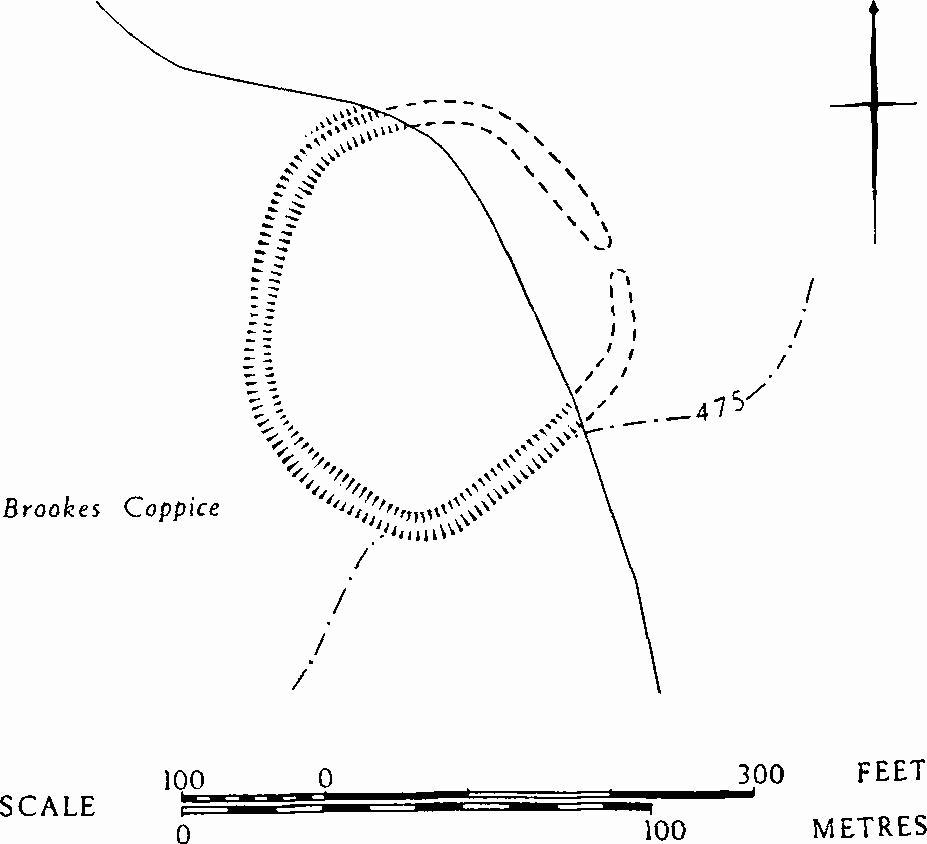
(26) Enclosure in Brookes Coppice
(29) Wor Barrow, a Neolithic long barrow (01241728), was totally excavated by General PittRivers in 1893–4. The present earthwork, a sort of amphitheatre, was created by him for the holding of exhibitions, games etc. (Plate 78, top left). The material from the mound was formed into a terraced bank along the S.W. side and the area within the ditch became an arena. The barrow is prominently sited near the crest of Handley Down and is clearly visible from the large group of barrows (Wimborne St. Giles (94–124)) on Oakley Down to the E., whose siting it may have conditioned.
Before 1893–4 the mound, aligned S.E.-N.W., was 150 ft. long, 75 ft. wide and 12 ft. high. Beneath it was found a rectangular enclosure, 90 ft. by 34 ft., with an entrance at the S.E. end. This enclosure was defined by a trench, 1½ ft. to 3 ft. wide and 3 ft. deep, packed with flint nodules which had formerly held timber uprights. Within the enclosure under a low turf mound lay six primary inhumations, three of them articulated and three in disorder.
The long barrow was surrounded by a ditch, steep-sided, flat-bottomed and interrupted by one causeway at the N.W. end and by three at the S.E. end. The ditch varied in width from 10 ft. to 25 ft. and for the most part was some 13 ft. deep, except at the N.W. end where it shallowed to 7 ft. Along the inner margin of the ditch on the N.E. and S. were traces of an earlier, shallower ditch, also interrupted; possibly it was contemporary with the rectangular enclosure under the mound. Two early Neolithic burials, an adult and a child, were found 8 ft. down in the main ditch at the S.E. end. The ditch also yielded a stratified sequence of pottery from early to late Neolithic. Seventeen Romano-British burials, eight of them headless, were found in shallow graves inserted into the mound and ditch, and much pottery of this period was found scattered in the upper filling of the ditch. Finds from the excavation are in the Pitt-Rivers Museum, Farnham.
Bibliography—Pitt-Rivers, Excavations IV (1898), 58–122. S. Piggott, Neolithic Cultures of the British Isles (1954), 53 ff. P. Ashbee, The Earthen Long Barrow in Britain (1970), passim.
Monuments (30–56), Round Barrows
Twenty-seven round barrows, several damaged or levelled by ploughing, have been recorded in the parish. Many have been excavated, most of them by General Pitt-Rivers, but very few completely. Pitt-Rivers reconstituted the barrows which he dug. The N.W. mound in the Settlement on Woodcutts Common (19) appears from excavation to be a Roman barrow.
(30) Barrow, probably Iron Age (98901443), on the N. slope of Gussage Hill, was removed by excavation in 1969. It lay immediately adjacent to the boundary dyke of the Iron Age and Romano-British Settlement, Gussage St. Michael (7). The mound, originally about 30 ft. in diameter, had been dug into in the past and was reduced by ploughing to 1½ ft. in height. It covered the remains of a cremation pyre among which were fragments of human bone and sherds of a pot of late Iron Age or early Romano-British type. A flint scatter was also found.
The mound lay within a ditch, 4 ft. to 6 ft. wide and 2 ft. deep, almost square in plan with sides about 50 ft. in length. The S. side was parallel to and probably later than the boundary dyke (Ant. J., L (1970), 26–36).
Thorney Down Farm Group (31–34) comprises four barrows on relatively low-lying ground N.E. of the farmhouse and immediately N. of the Salisbury-Blandford road. Monument (31) alone survives as an earthwork, and part of it has been cut away by the road; the others have been levelled by ploughing, but are visible on air photographs (C.U.A.P., AEK 95–6; RAF 58/3250: 0118, 0130).
(31) Bowl (99891533), was excavated by Pitt-Rivers (Excavations IV (1898), 172–81). The mound, 70 ft. in diameter and 2½ ft. high, covered a central cist in which was found a primary cremation, with a bone needle, a burnt flint knife and flakes, in an inverted collared urn (P.P.S., XXVII (1961), 294). In its upper levels the encircling ditch contained Romano-British pottery and three intrusive burials, probably of the same period.
(32) Barrow (99781541), diam. about 70 ft.
(33) Barrow (99821545), diam. about 60 ft.
(34) Barrow (99811550), diam. about 100 ft.
(35) Bowl (00461585), on the W. slope of Wyke Down, immediately S. of the Salisbury-Blandford road, was excavated by Pitt-Rivers (Excavations IV (1898), 172–81). The mound, about 50 ft. in diameter and 1 ft. high, covered three cremations in pits, none centrally placed, but all apparently primary; two were in collared urns, one of late Neolithic or earlier Bronze Age type (P.P.S., XXVII (1961), 294); the third had no associated finds. The surrounding ditch contained fragments of comparable pottery in the lower filling, and Romano-British pottery in the upper levels.
Three barrows (36–38), near the summit of Handley Hill, have been much reduced by ploughing. All were excavated by Pitt-Rivers.
(36) Bowl (01021653), about 50 ft. in diameter within the ditch and 2 ft. high, covered a cremation, probably primary, in a central pit and two secondary cremations in collared urns. A secondary, crouched, inhumation with a bronze awl was also found. (Pitt-Rivers, Excavations IV (1898), 144–7.)
(37) Bowl Barrow and Urnfield (00991655), 50 yds. N.W. of (36), comprised a low mound about 23 ft. across surrounded by a small penannular ditch with a causeway on the S.W. side. Beneath the mound were three pits, two interpreted as unoccupied graves. Immediately S.W. of the barrow some fifty-two cremations were discovered, nearly all in urns. Barrel urns were most common, but a few globular urns and one collared urn were also present. (Pitt-Rivers, Excavations IV (1898), 147– 57; Arch. J., CXIX (1962), 54–56.)
(38) Bowl (01131659), immediately E. of the SalisburyBlandford road; diam. 21 ft., ht. less than 1 ft. When excavated by Pitt-Rivers, nothing was found (Excavations IV pl. 244).
Two barrows (39, 40) lie just E. and N. of Wor Barrow (29), on the parish boundary with Wimborne St. Giles. Both were examined by Colt Hoare with little result (Ancient Wiltshire I 242), and they were subsequently excavated by Pitt-Rivers.
(39) Bowl (01281726), 40 ft. in diameter and 3 ft. high, covered a crouched interment, probably primary and accompanied by a belt 'slider' of shale. Fragments of a second skeleton were found near the centre (Pitt-Rivers, Excavations IV 58–61, 140–1).
(40) Bowl (01221738), about 50 ft. in diameter and 3 ft. high, lay within a very irregular ditch. Colt Hoare recovered traces of a skeleton from the mound. In the ditch Pitt-Rivers found an intrusive Romano-British burial in the remains of a coffin (Excavations IV (1898), 136–42).
(41) Bowl (95611738), in Calcots Wood, close to the boundary with Wiltshire; diam. 35 ft., ht. 2 ft. Pitt-Rivers found no burials in the mound, which appeared to have been opened previously (Excavations II (1888), 5, 37).
(42) Bowl (96871793), in Barrow Coppice, E. of Woodcutts Common, was excavated by Pitt-Rivers, who found a cremation, probably primary, near the centre (Excavations II (1888), 3). The mound, 46 ft. in diameter and 5 ft. high, is surrounded by a substantial ditch.
Scrubbity Barrows (43–50), a group of eight, lie on the S.W. slope of a dry valley in woodland between Woodcutts Common and Handley Common; all were excavated, but most only partially, by Pitt-Rivers (Excavations II (1888), 3–5, 32–44). A ninth mound (Pitt-Rivers xv) yielded no finds and from its irregular shape appears to be a spoil heap rather than a barrow.
(43) Bowl (97251788), (Pitt-Rivers ix) contained a primary crouched cremation in a boat-shaped tree-trunk coffin. A flint knife and axe and hundreds of flint flakes were found in the mound. Diam. 52 ft., ht. 4 ft.
(44) Bowl (97231790), (Pitt-Rivers x) covered an inverted collared urn, but no burial, in a central pit. A flint axe and numerous flint flakes were found in the mound. Diam. 64 ft., ht. 2 ft.
(45) Bowl (97221787), (Pitt-Rivers xi) covered what appears to have been the remains of a pyre, but no cremated bones were found. Diam. 28 ft., ht. 2 ft.
(46) Bowl (97211788), (Pitt-Rivers xii) contained a cremation burial and, beneath, a large grave 12 ft. by 9 ft. by 5 ft. deep, with nothing in it. Diam. 37 ft., ht. 3 ft.
(47) Bowl (97211789), (Pitt-Rivers xiii) covered a primary cremation burial. Diam. 24 ft., ht. 1 ft.
(48) Bowl (97251787), (Pitt-Rivers xiv) contained a cremation in a collared urn, centrally placed. Diam. 28 ft., ht. under 1 ft.
(49) Bowl (97171790), (Pitt-Rivers xvi) covered a cremation in an inverted collared urn which lay beside a long pit, possibly an unused grave. Diam. 37 ft., ht. 1½ ft.
(50) Bowl (97171789), (Pitt-Rivers xvii) in which nothing was found except a small pit. Diam. 40 ft., ht. 1½ ft.
Four small bowl barrows on Handley Common have been levelled by ploughing; (51) and (52) are at the N.W. end; the others lie further S.
(51) Bowl (97581861), formerly about 24 ft. in diameter.
(52) Bowl (97601862), formerly about 22 ft. in diameter.
(53) Bowl (97971793), formerly about 35 ft. in diameter.
(54) Bowl (97981791), formerly about 30 ft. in diameter.
Two barrows lie in Humby's Stock Coppice, S. of Handley Common (Dorset Procs., 73 (1951), 104–5).
(55) Bowl (98341699); diam. 34 ft., ht. 1½ ft.
(56) Bowl (98321700); diam. 48 ft., ht. 3 ft.