Ancient and Historical Monuments in the County of Gloucester Iron Age and Romano-British Monuments in the Gloucestershire Cotswolds. Originally published by Her Majesty's Stationery Office, London, 1976.
This free content was digitised by double rekeying. All rights reserved.
'Minchinhampton', in Ancient and Historical Monuments in the County of Gloucester Iron Age and Romano-British Monuments in the Gloucestershire Cotswolds, (London, 1976) pp. 81-84. British History Online https://www.british-history.ac.uk/rchme/ancient-glos/pp81-84 [accessed 11 April 2024]
MINCHINHAMPTON
(8 miles w. of Cirencester)
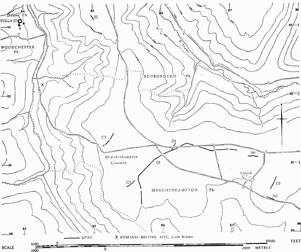
A gold stater of BODVOC now in Stroud Museum came from Camp Field in 1925. (fn. 1) A Roman brooch was found in a barrow on a 'table-land' in Hyde, N.E. of Minchinhampton, about 1845. (fn. 2) Two urns, one said to be a 'Roman olla', with bones and charcoal, were found during quarrying at Burleigh, N.W. of Minchinhampton, in 1845. (fn. 3) Roman pottery and tiles, perhaps from a kiln, have been noted near Little Britain (so 843021), near the valley bottom between Minchinhampton and Woodchester. (fn. 4)
Monuments (1)–(8)
Monuments in Minchinhampton, Rodborough and Woodchester.
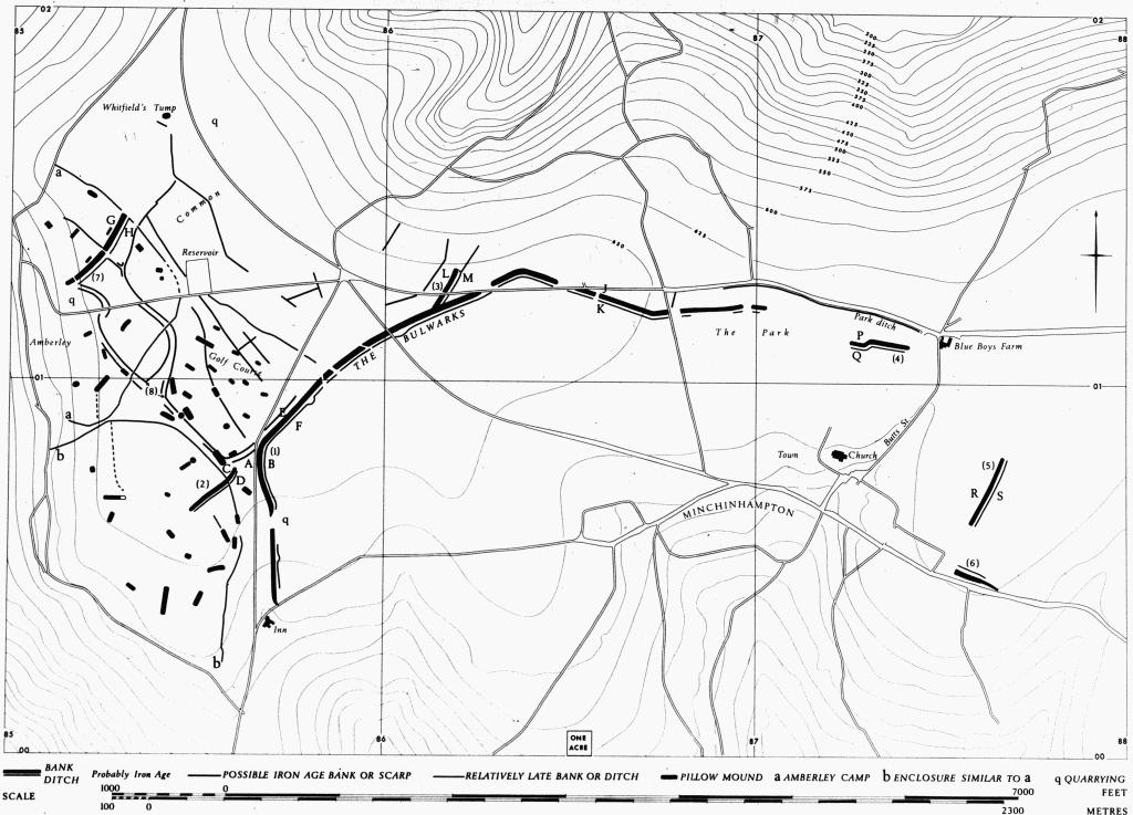
Complex, diverse and exceptionally well-preserved earthworks extend over the greater part of Minchinhampton Common, an almost flat-topped ridge capped by Great Oolite. North and east of Minchinhampton town there are more broken earthworks, and there has also been some levelling and creation of earthworks in later times. The gently sloping southern shoulder of the ridge is indented by re-entrant valleys in the area S. of monument (1). The earthworks include stretches of bank and ditch (1–7), various in form and size and probably if not certainly of the Iron Age, and a complex of long low banks (8) of uncertain but relatively early date, possibly Iron Age. Amberley Camp (so-called) is later; (fn. 5) its bank (a-a) touches an Iron Age rampart (7) which bisects the area, and also crosses elements of complex (8); it is known from excavation to lie over a pit which probably dates from historic times, one of many hundreds on Minchinhampton Common. It is matched by another large enclosure (b-b) immediately on the S., defined by a slight bank which crosses bank and ditch (2), itself probably of the Iron Age. Isaac Taylor noted 'wattle hedge' in this area on his map of 1777, but Bigland in 1792 could only guess at the origins of the earthworks. Fifty or more pillow mounds, including four or five round mounds, are probably relics of the rabbit farming which flourished in the region as late as the 18th century; one such mound is built on top of bank (2) and others lie on elements of complex (8). The pillow mounds and the pits are restricted to the S.W. half of the Common in an area bounded by the N.E. side of Amberley 'camp' and by a bank and ditch, 18 ft. across overall, which extends from the E. angle of the 'camp' to a break in The Bulwarks (1) at SO 85830102.
Neither The Bulwarks (1) nor the rampart (7) fully crosses the ridge-top, although the position of bank and ditch (2) suggests an unfinished attempt to prolong (1) to the scarp edge on the S.W. Present evidence suggests that The Bulwarks, probably continuous with and extending beyond bank (4), surrounded an area of more than 200 acres, now largely occupied by the town. The suggestion is strengthened by a reference in 1853 to 'the ancient earthwork which encloses the whole town' (Arch, XXXV (1853), 412–13).
Much disturbance, including at least two phases of enclosure and ploughing, and wartime construction (1939–45), conceal the probable link between (1) and (4) in The Park, an area defined on the N. by a relatively modern ditch. There are faint suggestions on air photographs that a ditch ran parallel with Butts Street, E. of The Park and S. of Blue Boys Farm. It is uncertain if bank (5), now isolated on the E., is of the same period as (1) and (4); if so, its relationship to the other earthworks is obscure since its ditch is on the E. side. The profile of bank (5) is akin to that of (1) at JK. A bank may have extended S. from so 87460049, some 200 yds. S.W. of (5). Feature (6), greatly disturbed, is of unknown origin. Rampart (7) may be tenuously linked to The Bulwarks by the complex of low banks (8), but its curve suggests that it faced The Bulwarks.
The very large area of these remains, their diversity, their dissimilarity from hill-fort or cross-ridge dykes, and the large area left open to the S. of (1) and (4), all stress their divergence from the pattern of Iron Age works repeatedly found elsewhere in the Cotswolds. Despite notable differences of arrangement and situation, the Bagendon complex (p. 6) is the only other Cotswold site of which this can be said. As yet, however, no true Belgic material has been found in Minchinhampton.
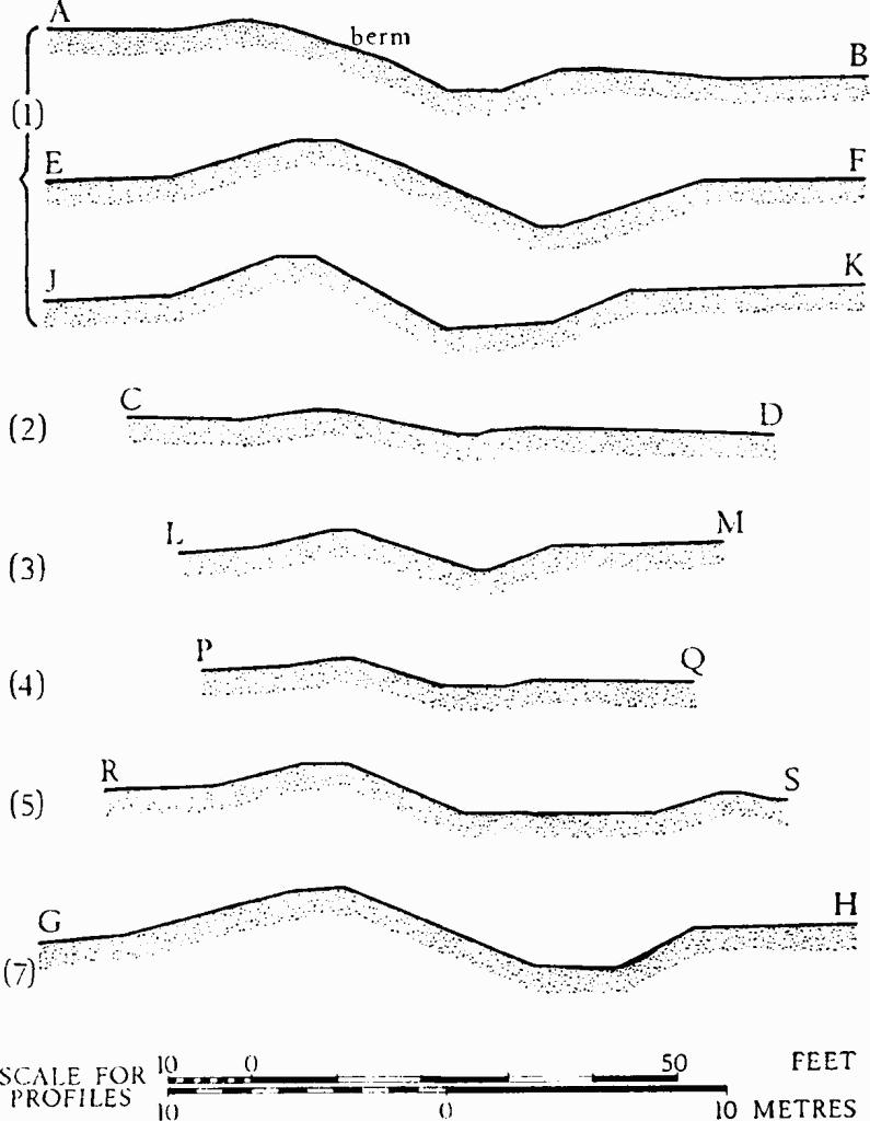
Minchinhampton. (1)–(8) Profiles
(Plan opposite.)
Occupation of Minchinhampton Common in the Romano-British period is shown by Roman tiles and pottery found during excavations in 1937 and also in the course of diggings among the widespread pits (e.g. PCNFC, V (1875), 288, 292; XIII (1898–9), 53–6). Similar material, now in Stroud Museum, came to light when wartime trenches were dug close to the reservoir.
Air Photographs: C.U.A.P., VAP RC8-L 152–7, V-CJ 81–100, V-CK 3–14, 24–33, 37–48, 60–7, 70–8, 85–98. RAF, VAP 3G/TUD/UK 102: 5071–5, 5103–8, 5156–61; CPE/UK 2098: F20, 3335–42.
Minchinhampton. (1) The Bulwarks, Iron Age bank and ditch. (2) - (8) Iron Age and undated banks and ditches.
C.U.A.P., OAP AIK 88–98, AIL 1–8, AIN 66–88, AJL 20–4, AMK 78–88, ARG 80–6.
Bibliography: Bigland (1791) II, 6. Playne (1872), 285–93. Witts (1883), 2–3. TBGAS, 59 (1937), 287–307 (excavation). Antiquity, XLII (1968), 312–14. Bagendon, 157. TBGAS, 80 (1961), 187.
(1) The Bulwarks, Iron Age Bank and Ditch (Plates 44, 45), extend for at least 11/8 miles from just N. of Halfway House Inn (SO 85700035) to a point in The Park (SO 87020120), beyond which they have been destroyed. Although the earthworks are continuous their form and scale of structure vary greatly: overall width from 47 ft. to 62 ft.; height of bank from 1½ ft. to 4½ ft. From the S.W. angle, N. of section AB, the ditch is relatively narrow and the bank is uneven and small; it is possible that the earthwork was once intended to continue S.W. on the line of (2). At section EF the ditch and bank are both some 8 ft. wider than at AB. As far as the N. angle (SO 86360130) there are surface indications of a berm on the E. side of the bank, and in 1937 Mrs. E. M. Clifford demonstrated its existence in her excavation some 400 yds. N.E. of section EF. Here the ditch, 9 ft. in front of a buried revetment wall, was 23 ft. across at the top and 7½ ft. deep; it had a flat bottom 5 ft. across. In the stretch E. of the northern angle (Plate 45 and profile JK) the character of the earthwork is entirely different from that hitherto described; there is no sign of a berm and the slope of the bank falling to the ditch bottom is particularly steep. Playne noted in 1872 that some part of the eastward continuation of the earthwork had been destroyed during the construction of The Park; he also averred that one of the two gaps near the N. angle, E. of (3), was an original entrance. It is probable that earthwork (4) represents a continuation of The Bulwarks. A roughly circular ditched platform in The Park (SO 870012), some 80 ft. in diameter and lying just N. of the line of the ditch, is of unknown origin.
The excavations of 1937 yielded Iron Age 'B' sherds from the bank as well as from the ditch, and Roman pottery from the ditch only. The finds are in Stroud Museum.
Bibliography: see above; also Rudder, 468; Witts (1883), No. 71; Playne (1876), 214, No. 31.
(2) Bank and Ditch, probably Iron Age, extend for at least 520 ft. S.W. from so 85600077 and are precisely sited at a slight change of slope on the W. side of a reentrant valley. Near its N.E. end the earthwork is crossed by the small bank and ditch of an enclosure (b–b) and to the W. of this point two pillow mounds lie, end to end, on its crest.
Bank and ditch are each about 16 ft. across and the bank is up to 1½ ft. high (profile CD). The S. portion, exactly in alignment with The Bulwarks (1), has been flattened by ploughing and may formerly have con tinued further S.W. The well-preserved N. part of the earthwork is bowed towards the E.
It seems possible that this earthwork represents an abandoned scheme to extend The Bulwarks S.W., rather than S., from the region of the angle at so 85670083.
(3) Bank and Ditch, probably Iron Age, extend for 400 ft. N.E. from (1), against which they appear to butt at so 86130117 (Plate 45). The natural slope drops gently from the N. end of the earthwork to the shoulder of the ridge about 190 yds. away. The earthwork is cut by the present road and the ditch is broken by quarries. At the N. end a low bank, probably cut by the ditch, lies approximately in line with the earthwork and extends N.E. for some 250 ft. Bank and ditch are each about 17 ft. across and the bank is about 2½ ft. high (profile LM).
(4) Bank and Ditch, probably Iron Age, in the E. part of The Park, extend for 450 ft. E. from so 87250110, some 800 ft. W. of the point where (1) is interrupted. Their continuation W. and E. has been destroyed. A sharp change in alignment near the W. end is unexplained. Generally the bank and ditch are each 12 ft. across, but at PQ they are respectively 21 ft. and 18 ft. across, and the ditch is 3 ft. below the bank (profile PQ).
(5) Bank and Ditch (SO 876007), possibly Iron Age, E. of The Old Grange (Rectory), are 600 ft. long and formerly continued N. and S. The bank is about 22 ft. across and 3 ft. high; the very wide ditch is of similar depth (profile RS). A causeway appears to have been inserted opposite the avenue leading from The Old Grange. Some 30 yds. S. from the S. end of the monument a shallow flat-bottomed depression extends E., tapering slightly.
(6) Bank and Ditch (?), possibly Iron Age, extend E. from a point 100 yds. S. of (5). The earthwork is greatly disturbed, and prominent only at the W. end; here the bank is 40 ft. broad and 2 ft. high above a poorly defined linear depression, 60 ft. across, possibly a ditch reused and widened as a track. The bank can be traced E. for 250 yds., eventually as a low scarp which turns towards the present road near the W. shoulder of the re-entrant from the south.
Bigland describes earthworks as extending to 'Woeful Dane Bottom', the re-entrant valley near by on the east. (Bigland (1791), II, 6).
(7) Iron Age Bank and Ditch, extend for 900 ft. N.E. from the escarpment edge at so 85140124. The two main parts, on either side of the only entrance which is certainly original, some 300 ft. S. of the N. end, are slightly angled, with the concavity facing N.W. The bank, 32 ft. across, is now about 4 ft. high (profile GH). The ditch is some 33 ft. across; Mrs. E. M. Clifford's excavation near the N. end in 1937 showed it to be 8 ft. deep, with a flat bottom 11 ft. across. Iron Age 'B' and so-called 'Belgic' pottery was found under the rampart and in low levels of the ditch. Finds are in Stroud Museum.
The work is now much disturbed, but there is no sign that the rampart ever continued further N. where an enclosure (a—a), 'Amberley Camp', appears to have been built against it. A low bank, part of complex (8), meets the ditch just S. of the entrance.
Bibliography: see above; also Rudder, 468; Playne (1876), 214, No. 30; Witts (1883), No. 4.
(8) Low Banks, undated, but possibly of the Iron Age, divide parts of Minchinhampton Common. The banks are mostly about 12 ft. across and 1 ft. high and there is no sign of accompanying ditches. They generally lie in straight runs or fluent curves and do not display the small, erratic changes of course apparent in parts of the enclosures (a–a), (b–b) mentioned above, and in the ditch S.E. of the reservoir. In places the ditchless banks run parallel, as if defining tracks up to 36 ft. across; three such 'tracks' converge on an 'open space' at so 854010. One part of the earthworks almost spans the gap between (2) and (1); another part spans between (1) and (7). The banks extend N. of the area occupied by the enclosures (a–a), (b–b), the pillow mounds and the pits, and the bank of Amberley 'camp' crosses them at three points. Low banks, not shown on the plan facing p. 82, exist on the town side of The Bulwarks (1), extending E. from so 857006. They are more prominent than most of the features embodied in monument (8).
C.U.A.P., VAP RC8-L 152–7.