A History of the County of Somerset: Volume 8, the Poldens and the Levels. Originally published by Victoria County History, London, 2004.
This free content was digitised by double rekeying. All rights reserved.
'Westonzoyland', in A History of the County of Somerset: Volume 8, the Poldens and the Levels, ed. Robert Dunning (London, 2004), British History Online https://www.british-history.ac.uk/vch/som/vol8/pp190-210 [accessed 30 April 2025].
'Westonzoyland', in A History of the County of Somerset: Volume 8, the Poldens and the Levels. Edited by Robert Dunning (London, 2004), British History Online, accessed April 30, 2025, https://www.british-history.ac.uk/vch/som/vol8/pp190-210.
"Westonzoyland". A History of the County of Somerset: Volume 8, the Poldens and the Levels. Ed. Robert Dunning (London, 2004), British History Online. Web. 30 April 2025. https://www.british-history.ac.uk/vch/som/vol8/pp190-210.
In this section
WESTONZOYLAND
TOPOGRAPHY
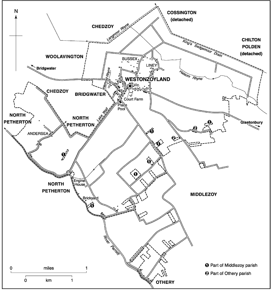
The parish was formed in 1515 by the division of the parish of Sowy. Westonzoyland derives its name from its position as the western settlement on Sowy, the name given, probably before 1066, to the 'island' between the rivers Cary, since displaced by the King's Sedgemoor Drain, and Parrett. (fn. 1) The parish includes the village, the hamlets of Bussex and Liney to the north and north-east, and settlements at Andersea, Ham or Hamland, (fn. 2) and Moorland, extending into Middlezoy, to the south-west beside the Parrett. The irregular shape of the parish is largely caused by allotments of moor made under the inclosure Act of 1795 (fn. 3), although the boundaries of Westonzoyland tithing were probably defined in the Middle Ages and included the river Cary in the north and the river Parrett in the southwest. (fn. 4) In 1840 the parish measured 2,656 a. (fn. 5) A detached part of Woolavington around Penzoy Farm was absorbed by the parish in 1885 and changes were made to the boundary with Middlezoy in 1886, probably including the absorption of detached fields, (fn. 6) making a total of 3,316 a. (fn. 7) Minor alterations in 1981 produced a slight increase to 1,371 ha. (3,387 a.). (fn. 8)
Sowy 'island' is formed by Burtle Beds of sand and gravel. At its flatter, western end the moors to the north and south are mostly of peat with a narrow strip of mudstone immediately to the south of Westonzoyland village and alluvium beside the Parrett. (fn. 9) The core of the village and much of the former airfield and earlier Weston open field to the west lie between 7 m. (23 ft.) and 10 m. (33 ft.), falling away north across Land moor to 4 m. (13 ft.) at King's Sedgemoor Drain, west to 5 m. (16 ft.) beyond Penzoy, and south to 4 m. (13 ft.) on Place Drove. To the south-west the land falls to 5 m. (16 ft.) along Lake Wall and rises to 8 m. (26 ft.) beside the Parrett between Andersea and Moorland, probably the site of the former Ham or Hamland. (fn. 10) Langmead and Weston Level have been declared an area of Special Scientific Interest because of grasses and other plants. (fn. 11)
COMMUNICATIONS
Until the building of Greylake Fosse, probably in the late 13th century, access to Sowy 'island' was difficult. A spine road between Westonzoyland and Greylake, known as the great road, was in existence by c. 1220 (fn. 12) and was linked with the Fosse and thus with Glastonbury. Lake Wall, probably built in the late 13th century, provided a dry route for most of the year between Westonzoyland village, Andersea, and the river Parrett. The great road had been continued west to Bridgwater by the later 17th century, (fn. 13) although the Parrett continued to be well used up to Langport until the coming of the railway in the 1850s. (fn. 14) The road from Bridgwater to Greylake Fosse was turnpiked by the Bridgwater trust in 1730 as far as Langport Bridge, west of Penzoy, (fn. 15) and from there in 1826 by the Langport, Somerton, and Castle Cary trust through Westonzoyland towards Greylake. That part of the road east of the village was closed c. 1943 when the airfield was extended and replaced by a route south-west along Place Drove to Thorngrove in Middlezoy. The previous route was largely reinstated c. 1969. (fn. 16) The road crossed Hamrod rhyne by Hamrod Bridge, a single arch bridge which was enrolled as a county bridge in 1880, reflecting the importance of the route. (fn. 17)
Westonzoyland parish 1836
POPULATION
Forty-four men and one woman were fined in 1497. (fn. 18) There were said to be 118 houses in the parish in the 1780s. (fn. 19) The population rose from 677 in 1811 to a peak of 1,007 in 1851 but fell to 894 in 1861 and to 663 in 1881. Thereafter it remained fairly stable until the later 20th century when the total rose rapidly from 661 in 1951 to 763 in 1961, to 1,351 in 1971, and to 1,769 residents in 1991 as the village became a dormitory for workers in Bridgwater. (fn. 20)
SETTLEMENT AND BUILDINGS
The Burtle sands appear to have been settled in Prehistoric times and sherds of Romano-British pottery have been found. Prehistoric flints have also been found at Liney. There was an Iron-Age settlement north-east of the church which appears to have been re-used in the 3rd and 4th centuries. (fn. 21)
Westonzoyland village was probably a Saxon settlement and in the Middle Ages grew up around the church and manor house, east of the arable field. It was known during the Middle Ages as Weston or sometimes Weston Abbatis, (fn. 22) in recognition of its ownership by the abbots of Glastonbury. The present village lies along the north - south road from the church to Lake Wall, the roads to Bridgwater and Middlezoy which lead out of it, and short side roads. During the later 18th century occupation spread eastwards from the church to Townsend and from there north towards Liney, (fn. 23) and also westwards towards the road to Bridgwater, where several plain brick houses survive. There are few obviously old houses in the village; those that may have been built before the mid 19th century are long and low and have the traditional cross-passage plan. They lie north-west of the church and on the Bridgwater road. Brick-casing, render, and slate have in at least one case, that of a house in Lodes Lane, been applied to a cob-walled building of uncertain date. Cob walling can also be seen in an outbuilding at Broadstone Farm.
During the later 19th century the village continued to expand in all directions including a number of landless, owner-occupied houses, small farmyards, and workshops. (fn. 24) The greatest concentration of 19thcentury houses is along the Bridgwater road, where there are several three- and five-bayed red brick villas. They are classical in style and most have rusticated lintels, a West Country motif. Monmouth House, on the north side, has a cast-iron verandah and balcony. Some large brick farmhouses were also built during the same period. Similar to the villas in style, they stand together with well laid-out large brick farm buildings. In the village the most notable are the red-brick Broadstone Farm and a farm of yellow brick on Monmouth Road. At Liney are two such farms, one called Liney House. Easthaven was probably the commander's house for the local air force base. It is a Neo-Georgian Ministry of Works type house, possibly part of the 1952 revival of the base. Local authority housing, and from the 1960s owner-occupied houses, were built in the area to the north and north-west of the church in styles alien to village tradition (fn. 25) and infill and replacement housing, including a housing association development, occupy the sites of farms and cottages which formerly lay south of the Bridgwater road. Several large 19th-century houses were unoccupied in 2000.
The hamlet of Liney to the north-east had been established by the mid 13th century with its neighbouring farmstead of Ferny. (fn. 26) Liney had about seven houses in 1516 (fn. 27) and ten in 1841. (fn. 28) West of Liney is Bussex, a new settlement of nine cottages in 1600. (fn. 29) The scattered surviving houses, mostly 19th-century, may be on the same sites. Sloo on the northern edge of Weston field was attached to Middlezoy vill in 1308 when it may have had three houses. (fn. 30) Only one house was recorded in 1516 when it belonged to the rectory. (fn. 31) The site had been abandoned by the 19th century. (fn. 32)
Andersea, recorded as an island (fn. 33) in the 12th century, (fn. 34) straggles along a lane running from the river bank towards Westonzoyland on slightly drier ground amongst old inclosures. It had nine houses in 1841 (fn. 35) and new houses were built in the early 20th century. (fn. 36) To the south along the river bank as far as Burrowbridge lies the scatter of houses known as Moorland and originally lying in Westonzoyland, Middlezoy, and Othery. (fn. 37) The area to the south of Lake Wall, known as Hamland, was a planned medieval settlement of 24 houses of which 21 remained in 1516. (fn. 38) The name had been abandoned by 1600 and the remaining houses classed as part of Moorland. (fn. 39) A scatter of cottages encroached along Lake Wall, totalling 22 by 1851, but by 1886 few remained. (fn. 40)
SOCIAL LIFE
The Westonzoyland Society, founded 1799, was probably replaced by the Westonzoyland Benevolent friendly society in 1818. The Westonzoyland friendly society was recorded in 1840 and a seven-year friendly society in 1849. (fn. 41) A provident clothing club had c. 30 members between 1862 and 1871. (fn. 42)
Four cottars paid to be free of toll on ale selling or brewing in 1308 (fn. 43) and in 1315 24 ale sellers were in breach of the assize. (fn. 44) In 1516 a tenant of the manor paid 2s. 4d. to have an inn in his cottage and to brew, and another paid 1s. for toll on ale for his cottage. (fn. 45) Two tapsters were recorded in 1536, (fn. 46) an alehouse in 1606, an unlicensed tippler in 1607, and two unlicensed tipplers in 1620. (fn. 47) In 1647 four men kept unlicensed tippling houses. The parishioners petitioned in 1651 to be free of alehouses, saying that they needed none, and secured an order that no licences be issued without special consent. (fn. 48) In 1674, however, two victuallers were licensed and an inn was recorded in 1678. (fn. 49) During the 18th century there was only one licensed house, known by 1777 as the Inn and after 1779 as the Three Greyhounds. (fn. 50) A shooting match was held there in 1812, and in 1814 a friendly society met there. (fn. 51) The name was changed to the Sedgemoor Inn c. 1970. The inn, west of the church, is a late 15th-century building with a jointed-cruck roof and a smoke hood. (fn. 52) A second beerhouse, the Shoulder of Mutton, had opened by 1840 on the main road south of the church. (fn. 53) It was kept in a two- or three-room cross-passage house which was later extended and in 1929 was totally rebuilt. (fn. 54) It closed in the 1990s and was divided into several dwellings.
The parish held an ale and elected a Robin Hood in 1606. (fn. 55) In the 1780s a revel was held on the Monday before Whitsunday. (fn. 56) A church hall was built in 1933 on the National school site and incorporated the original building. It had a hall, kitchen, and billiard room and in 1934 was extended to provide a skittle alley. (fn. 57) A men's club was held between 1932 and 1937, (fn. 58) and a branch of the Women's Institute was formed in 1938 but suspended in 1981. (fn. 59)
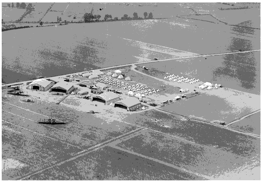
Westonzoyland, airfield, 1927
NATIONAL EVENTS
The clubman Humphrey Willis is said to have spoken to a crowd at Penzoy pound a few days before the battle of Langport in 1644, and Fairfax mustered his army at Penzoy after the battle on his way to Bridgwater. (fn. 60)
The battle of Weston, later known as Sedgemoor, between the armies of the king and of the duke of Monmouth, was fought on 6 July 1685 on the moors north of the village. (fn. 61) It lasted barely an hour but contemporaries gave the number of dead between 727 and 2,700, the former more likely. It was said that most of the 27 fatalities from the king's army were buried in the churchyard, one with a canon ball in his chest, (fn. 62) or on the battlefield, and the church was used to contain the prisoners, some of whom were hanged in the village. The parish bought frankincense, pitch, and resin to clean and disinfect the building afterwards and paid for ringing for a day of thanksgiving then and a year later when the king was in the parish. Only eight local men were accused of involvement, one of whom died while being transported to Barbados. (fn. 63) In 1927 a plain memorial stone was set up on the battlefield site, where bones had earlier been found. (fn. 64)
The former Weston open field (fn. 65) which stretched eastwards into Middlezoy became the site of annual summer training camps for the Royal Air Force between 1926 and 1939. In 1940 it became a 'fullyfledged self-accounting station' and in the following year at least one house in the village and the village hall were commandeered when it became a camp for training pilots to bomb gun positions and two gliders. In 1943 the runways were extended and the Middlezoy road diverted; in 1944 the coming of a large unit from the United States in preparation for the D-Day landings involved new buildings in Westonzoyland and Middlezoy. The station was virtually abandoned in 1946, revived in 1952, and was closed in 1958. In 1969 the site was sold and the Middlezoy road was rerouted using part of the runway. A section of the airfield was still used in 2000 for flying microlight aircraft. (fn. 66) In 1941 a German Heinkel was shot down at Andersea. (fn. 67)
MANOR AND OTHER ESTATES
SOWY MANOR
In 1066 Glastonbury abbey held an estate called Sowy (fn. 68) which it was claimed had been granted to the abbey by King Ine in 725 and by King Aethelwulf in 854. (fn. 69) By the early 16th century, and occasionally earlier, Sowy was regarded as three separate manors of which Weston was the chief. (fn. 70)
WESTONZOYLAND MANOR
At the dissolution of Glastonbury abbey in 1539 Westonzoyland manor passed to the Crown, (fn. 71) which retained it until 1547 when the manor was among estates granted to Edward Seymour, duke of Somerset. (fn. 72) After his attainder in 1552 it was leased for 31 years to Sir Henry Sidney, then principal gentleman of the privy chamber, (fn. 73) and in 1566 the reversion was granted to Robert Dudley, earl of Leicester. (fn. 74) Soon afterwards Dudley was licensed to alienate to Sir Thomas Gresham (fn. 75) but in 1570 Dudley sold the reversion to (Sir) Edward Dyer. (fn. 76) Meanwhile Sidney was said to have assigned his lease to Thomas Moore, a Taunton merchant. (fn. 77) Dyer mortgaged and forfeited the manor to the Crown (fn. 78) in or after 1600 (fn. 79) and at his death in 1607 it passed to Sir Thomas Egerton, Baron Ellesmere (later Vct. Brackley), the Lord Chancellor. (fn. 80) In the following year it was acquired by Peter Vanlore. (fn. 81) Sir Edward Powell, Peter Vanlore's son-in-law, seems to have taken possession on Vanlore's death in 1627, but in 1638 the manor, heavily mortgaged, was assigned to Peter's son and namesake, Sir Peter Vanlore, Bt. (fn. 82) The latter before his death in 1645 appears to have sold it to Dr. Arthur Duck (d. 1648). (fn. 83)
In 1672 Martha, one of Arthur Duck's two daughters and coheirs, placed one half of the manor in trust for her daughters, and in 1687, after her death, her son Richard Duck conveyed the other half to the same trustee, George Crane, under the terms of a Chancery decree. Both Duck and Crane sold some of the land to pay Duck's debts, creating freeholds held by the Bridge, Chapman, Strangways, and Prankard (later Dickinson) families. (fn. 84) In 1723 Susanna Bridge's estate was described as a manor. (fn. 85)
The rest of the Duck estate was offered for sale in 1696 (fn. 86) and by 1703 was acquired by Benjamin Hawkins, an Exeter merchant, who was succeeded by his daughters Elizabeth, Jane, and Mary. (fn. 87) Jane died without issue and her third was shared between her sisters. In 1709 Elizabeth married Simon Welman (d. 1716) of Poundisford in Pitminster, and in 1731 Mary married Simon's brother Thomas (d. 1757). Elizabeth (d. 1764) was followed by her son Isaac Welman (d. 1782) and by Isaac's son Thomas (d. 1829), who left a son Charles. Mary (d. 1760) left a daughter Elizabeth who married William Hawker in 1755. By his will dated 1804 Hawker left his estate to his three daughters Mary, Elizabeth, and Ann, from whose many children and heirs Charles Welman acquired it piecemeal between 1839 and 1841. (fn. 88) Charles (d. 1907) and his mother Charlotte (d. 1869), who married Thomas Thompson in 1839, held jointly nearly 1,000 a., but subsequently much land was sold and lordship was not recorded after 1865. (fn. 89)
Manorial Buildings
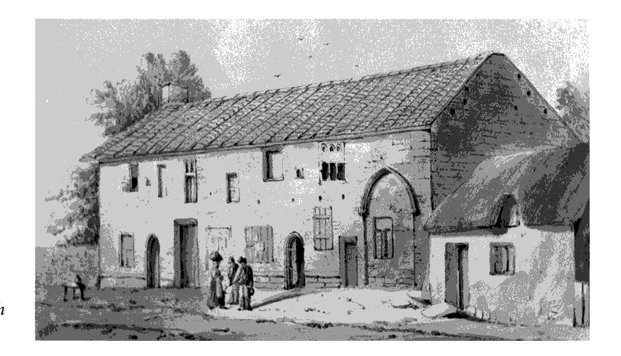
The medieval manor house stood in the main street of the village opposite the church. New stables and a chamber were built c. 1281. (fn. 90) The abbot's chamber recorded in 1299 may have been the great chamber mentioned in 1302; by 1300 there were also a hall and great gate. (fn. 91) The buildings including a barn were covered in stone tile and surrounded by an 8-ft. wall with posterns. A dovecot was built in 1315, and by 1333 the buildings included a great chamber, kitchen, pantry, buttery, larder, and other domestic offices, an entrance gate, almonry, and chapel, and rooms for reeve, bailiff, and carter. (fn. 92) The house was evidently rebuilt by Abbot John Selwood (d. 1492) and in 1516 the 12-a. site included what was described as an ample, large, and sumptuous mansion containing a hall, chambers, a chapel, (fn. 93) a kitchen, and spacious offices. There were two large courts, one containing a garden, orchard, bakehouse, and stable, the other with farm buildings including a large granary, and a dovecot. (fn. 94) About 1540 it was said that there were five chambers within the hall and one great chamber without for servants. (fn. 95)
In 1540 the house was let to Thomas Dyer. (fn. 96) By 1600 it was known as Weston House, (fn. 97) in 1605 as Parsonage Grange, (fn. 98) and by 1801 as Court House. (fn. 99) Under the Vanlores the house was used by an agent and was in poor repair. (fn. 100) It was paritally demolished in the later 18th century (fn. 101) and was 'much dilapidated' in 1846. (fn. 102) By the 19th century part of the late medieval house had been converted into a barn or byre. (fn. 103) Most of the farm buildings had been demolished by 1886. (fn. 104) The house was pulled down c. 1932. (fn. 105) Its replacement, Court Farmhouse, was built in 1935. A house on part of the manor house site, known as the Priory or no. 20 Main Road, was built in the mid to late 19th century, and part facing the road is stone faced with engineering brick dressings. The main doorway and window over it incorporate the arches of a 15th-century, probably domestic, building. (fn. 106)
RECTORY ESTATE
Sowy rectory was appropriated to Glastonbury abbey in 1268 (fn. 107) and in 1291 was valued at £33 3s. 8d. (fn. 108) The abbey retained the estate, consisting of land and the great tithes, until the Dissolution. (fn. 109) In 1535 it was valued at £65 6s. 8d. (fn. 110) About 1540 the value was £80 (fn. 111) and in that year it was let with some land and the manor house to (Sir) Thomas Dyer for 21 years, (fn. 112) extended by a further 40 years from 1560. (fn. 113) In 1548 the rectory passed by exchange to the bishop of Bath and Wells, (fn. 114) who in 1550 granted Dyer a lease for 99 years. (fn. 115) The lease was renewed in 1600 for a further 50 years. (fn. 116) In 1605 Sir Edward Dyer, son of Thomas, assigned the lease to Francis Dyer of Tickenham and in 1610 granted it outright. (fn. 117) By 1630 the rectory was held by Jacoba (d. by 1636), widow of Peter Vanlore. In 1638 following litigation it was awarded to her daughter Mary, wife of Sir Edward Powell, Bt., who had seized his wife's estates after her father's death in 1627. (fn. 118) Powell was again ordered to hand over his wife's property in 1640, and in 1642 Mary's brother Sir Peter Vanlore settled the rectory on his daughter Mary, presumably in reversion. In 1644 the rectory was said to have been sequestered, although Lady Powell had supported Parliament. (fn. 119) As episcopal property it was sold in 1651 to William Dingley, and by 1657 it was farmed by Jane Oswold and Mr. Powell, probably William. (fn. 120) In 1661 to William Dingley, and by 1657 it was sold in 1651 to William Dingley, and by 1657 it was farmed by Jane Oswold and Mr. Powell, probably William. (fn. 121) In 1661 James Oswold let half the rectory to William Powell (cr. Bt. 1661), nephew of Sir Edward Powell. Sir William settled it on his daughter Mary's marriage to Sir John Williams. Sir John assigned it to his father-in-law in 1676. (fn. 122) By 1689 the Bridges family was leasing the rectory from the bishop, and in 1724 they were succeeded by the Wynne family. (fn. 123) In 1846 just over 29 a. of rectory land was attached to the parsonage house and there was a further 89 a., some of which was claimed as freehold. (fn. 124) In 1863 the reversion of the estate was sold by the Ecclesiastical Commissioners to John Wood, probably in trust for the tenants. (fn. 125)
In 1600 the great tithes from the three parishes of Westonzoyland, Middlezoy, and Othery were valued together at over £400 a year. (fn. 126) In 1834 most great tithes of Westonzoyland were commuted for a variable sum and the rest in 1840 for £40. In 1846 the tithe rent charge was £232. (fn. 127) The rectorial tithes of Othery were commuted for £299 in 1841 and those of Middlezoy in 1852 for £21 15s. 2d., except for those commuted in 1800 for a variable sum. (fn. 128) In 1893 the variable rent charge for Westonzoyland was fixed at £142. 4s. (fn. 129)
OTHER ESTATES
Part of the vicar's glebe was known as the vicarage manor from the 17th century. (fn. 130)
There were small holdings at Andersea which included a rent charge owned by Muchelney abbey on the estate of Richard le Bule by 1211 (fn. 131) which was still payable in 1553. (fn. 132) Some land there was also owned by the abbey by 1333, (fn. 133) and at the Dissolution it was described as a manor and passed to Edward Seymour (d. 1552). (fn. 134) It was subsequently occupied by the Bragge family until 1691. (fn. 135) Land granted to Athelney abbey by Roger de Mandeville in the mid 12th century does not seem to have been retained. (fn. 136) The Revel family, lords of Curry Rivel, also seem to have held land in Andersea in the later 12th century (fn. 137) which was occupied by the St. Clare family of Stapleton in Martock in the 14th century. (fn. 138) In 1451 Walter Norton and William Moore were said to hold lands in Andersea of Curry Rivel manor by knight service (fn. 139) and Robert Brent (d. 1508) held jointly with his son John lands in Andersea of the countess of Richmond's manor of Curry Rivel. (fn. 140)
A farm in Andersea formed part of Dunwear manor in Bridgwater until after 1621 when it was let by Sir Robert Chichester to Philip Holman. It was bought from the Holmans by Joan Lockyer in 1692, and by her will proved in 1702 it passed, subject to the life interest of her husband Ambrose Budd, to her sister Mary, wife of George Raymond (d. 1728), with remainder to Joan's nephew John Lockyer. (fn. 141) Raymond, who held the adjoining Norman's, later Raymond's, farm, (fn. 142) held it in 1717, but John Lockyer was in possession by 1727 and was succeeded by Thomas Lockyer (d. by 1787). After his death the estate (c. 77 a.) was split up. A small farm, known as Andersea, passed to Thomas Gould who was followed by Samuel Wilcox. (fn. 143) Raymond's farm, in 1748 a 52-a. estate held by George's nephew William Raymond (d. 1749), had become part of William Chard's estate by 1787. (fn. 144)
ECONOMIC HISTORY
MEDIEVAL AGRICULTURE
The estate of Sowy gelded for 12 hides in 1066 and in 1086 had 20 ploughlands. There were 5 hides in demesne with 2 ploughs worked by 2 serfs. There were 30 a. of meadow and 12 a. of underwood. Demesne livestock comprised 17 cattle, 18 pigs, and 50 sheep. The remaining 7 hides were worked by 27 villeins and 13 bordars with 14 ploughteams. There were also 12 freedmen. The estate appears to have been either undervalued in 1066 or greatly improved by 1086, having increased in value from £10 to £24. (fn. 145)
The Sowy demesne, largely in Westonzoyland, was farmed out in the mid 12th century with a herd of 20 cows and 20 other cattle, and 4 sows with 20 other pigs.
The cows had gone by 1171 and there were fewer pigs, many having perished together with colts when the moors were under water. However, a bull and four oxen were kept and the abbey received over £11 in cash and honey rents. (fn. 146) In 1189 there were only 15 cows although 60 or more could have been supported. There were also 14 non-draught cattle, 13 calves, 15 pigs, and 16 piglets. The land was well cultivated and harvested but the abbot had a meadow on the moor, some of the hay from which had been spoiled. The only demesne worker, a cowherd, was quit of services. Tenant holdings were mostly in Middlezoy and Othery; Westonzoyland had only 7 half-virgaters, 4 or 6 holders of 7½ a., 15 of 5 a. (3 holding demesne land), and 1 tenant holding 2½ a. All paid cash rents, totalling £3 11s. 4d. except some of the 5-a. tenants who worked every other day and paid poultry rents at Martinmas. The half-virgaters ploughed ½ a. each week and performed one work between Michaelmas and 1 August, but for August and September worked on five days each week when required, carried with pack animals (summagium) when ordered, ploughed 1½ a. as boonwork, harrowed and reaped 1½ a., carried dung, and went to the vineyard. Smaller tenants had reaping and haymaking duties, carried dung, and served in the vineyard. (fn. 147)
By 1201 the abbey received over £13 in assize rent from the whole manor, payments in kind including loads of osiers, 20 church scot hens, a sester of honey, and 3,000 eels from the fishery at Statheweir in Othery. Tenants owed works including 61 a. of ploughing. The demesne covered 509 a. and livestock comprised a bull, 12 cows, calves, and other cattle, mares, and a boar and pigs, but it was stocked at only half its capacity. (fn. 148)
Over the next 60 years the Sowy demesne doubled in size and by c. 1260 measured c. 1,050 a. valued at nearly £76. (fn. 149) Expansion was made possible both by encroachment into the surrounding moor by means of small-scale drainage by tenants, and by sharing agreements between adjacent lordships. (fn. 150) About 272 a. were taken from the moors c. 1236 and let, usually in small plots; the rent at first was low until the grassland improved. Plots near Burrow and in Southlake in Othery were larger but no more valuable, probably because of the high risk of flooding. (fn. 151) Burrow and other walls were probably built in the early 13th century. (fn. 152) On a larger scale, an agreement was made in 1235 between the abbot of Glastonbury and William de Montagu, lord of Chedzoy, to share the 800-a. Weston marsh and to establish a jointly owned pound at Penzoy. (fn. 153)
About 1260 the Sowy demesne included 128 a. of meadow of varying quality and 432 a. of permanent pasture. The pasture lay in Westmore (350 a.), Vergmore (50 a.), and Cowleaze and Oxenleaze (32 a.). Summer pasture reckoned as part of the demesne was sufficient for 30 cows, 8 beasts, and 1 draught horse, and the lord's share of common pasture supported 240 animals including 100 pigs. (fn. 154) Improvement in the moors continued into the early 14th century. One man was said to have improved 5 a. of moor in 1262, and in 1265 a tenant paid an increase in rent for herbage of a drove at Liney. (fn. 155) Continuing encroachments were evidently not all with the abbot's approval: freeholders agreed in the 1260s, 1281, and 1292 to surrender their recently recovered fields and in 1281 agreed to allow the abbot to make encroachments anywhere in the moors. (fn. 156) By 1302 the abbot was said to have appropriated 160 a. in the moor between Greylake and Othery and a further 35 a. had been inclosed by freeholders. (fn. 157)
About 1260 demesne arable measured 491 a. in units ranging between less than an acre and just over 58 a. (fn. 158) There were four arable fields, one each in Westonzoyland and Middlezoy, and two in Othery. Weston field lay east of Westonzoyland village. (fn. 159) In 1258 corn sales produced £41 and wheat had been sown on 140 a., most of the 161 qr. produced going to the abbey granary. The estate also produced large quantities of beans, peas, and oats. Sixty-nine oxen were required for ploughing. (fn. 160) Later in the century the amount of arable under cultivation fluctuated, perhaps partly because of weather conditions. Thus in 1268 the new vicarage was endowed with the tithes of 197 a. of meadow in Langmead and Bennet, lying between Westonzoyland and Middlezoy, whether corn or hay was grown. (fn. 161) In 1275 no corn sowing was recorded and there were only 6 oxen on the manor; (fn. 162) in 1281 the manor was expected to supply the abbey with at least 168 qr. of barley and 40 qr. of oats; (fn. 163) in 1300 wheat was sown on 52 a., rye on 3 a., barley on 90 a., and beans on 40 a., in a year when the grange was extensively repaired following a great gale. (fn. 164) In 1303 and 1305 there were substantial sales of grain and c. 200 a. was sown each year, mainly with barley, producing two types of malt for the abbey. However, there was only one demesne plough, (fn. 165) and by 1308 the demesne had shrunk to 332 a. of which 188 ½ a. was arable. Former demesne arable was let either in small parcels of overland or plots of over 20 a. (fn. 166) In 1314 188 a. was sown with barley, wheat, and beans, (fn. 167) and a similar quantity of demesne continued to be cultivated in the early 1330s, but in 1334 all the oxen were disposed of although there were 21 horses and colts. (fn. 168) It is possible that the 355 qr. of barley and 147 qr. of wheat supplied to Glastonbury from Sowy in 1362 came from tithes. (fn. 169)
In 1258, apart from plough beasts, the demesne supported 12 cows, 37 pigs, and 35 geese. (fn. 170) In 1275 a gooseherd looked after 419 geese, including 310 bought that year. Other stock then included 25 cows, which produced 132 cheeses and 3 stone of butter, 150 pigs, 2 cranes paid as rent from Greylake, 22 peacocks, 5 ducks, and 8 hives of bees. (fn. 171) By 1300 the dairy herd had increased, the 35 cows producing 407 cheeses and 6½ stone of butter; there were 25 hives, 53 piglets were born, and 21 peafowl were hatched. (fn. 172) There was a withybed in 1305, and the demesne orchard produced c. 35 qr. of cider apples in the early 14th century. (fn. 173) In 1312 the dairy produced 356 cheeses and 10 stone of butter. A waggon house contained 5 carts and 2 dung putts, and there was a pool and a poultry house. (fn. 174) In 1314 ten hives of bees died, half the stock, and several peacocks were lost but 416 cheeses and two doles and one pipe of cider were produced. (fn. 175) In 1334 102 piglets were born and 3 peacocks produced 36 feathers for the abbot to give away. (fn. 176)
In 1275 the manor employed four carters and two drovers, half of them part-time, a hayward, a dairyman, and a gooseherd. The rectory estate was concerned mainly with grain tithes and eight carters were employed in 1275 as well as a horseman in each vill and a hayward. (fn. 177) Large numbers of casual workers were sometimes employed, such as the 160 men hoeing barley in 1301, when the manor had eleven tables and trestles, a lavatory, and over 60 dishes, plates, saucers, and cups, and supplied bean pottage, and probably cheese, bacon, and cider. (fn. 178) In 1302 a fisherman and a gooseherd were employed on the rectory estate which had five tables with trestles, a lavatory, and 127 dishes for a household which numbered nearly 40 people in 1304 including carters, waggoners, and stackers. (fn. 179)
Rapid progress was made with encroachments into the surrounding moors in the first 60 years of the 13th century. In 1258 manor rents totalled over £50 (fn. 180) and £20 8s. 7d. moor penny (morgabulum) rents (fn. 181) were received from the tenants of the three vills in the mid 13th century, an increase from earlier in the century and about half the total rental. (fn. 182) By c. 1260 most tenants paid as much or more in moor in moor penny rent as for their tenements and the demesne estate included 400 a. of moor worth more per acre than some of its meadow and arable. However, works were onerous and worth more than rents. (fn. 183) By 1275 moor penny was no longer recorded separately, implying that the improved land had been incorporated into holdings, (fn. 184) and by 1308 no demesne moor was recorded and there was enclosed pasture and meadow called Burmore and arable called Broadmore. (fn. 185) Attempts were made to preserve alder on the moors. (fn. 186) The bishop complained in 1315 that the abbot of Glastonbury had made dykes in parts of 'Sowyland' which caused flooding. (fn. 187) In 1317, on the orders of Matthew of Clevedon, lord of Aller, the walls were cut and the abbot of Glastonbury claimed that 1,000 a. of wheat, barley, beans, peas, and oats, 50 a. of meadow, and 300 a. of pasture were flooded for two years at a cost of £1,333 6s. 8d. That indicated that a great quantity of moorland had been reclaimed between the Parrett and Sowy island from Southlake to Weston moor. In 1321 the abbot recovered damages and an undertaking from Matthew not to enter the abbot's land again. (fn. 188)
In 1291 the manor was valued at £180 but actual receipts totalled between £250 and £300 a year. (fn. 189) In 1300 money was received from new rents, a sum which increased annually until 1305 or later. (fn. 190) The rental with farms totalled over £152 in 1334 with c. £45 from release of works. (fn. 191) The same year Sowy was assessed for the subsidy at nearly £26, over half the total for the hundred and far more than many towns in the county. (fn. 192) In 1331 it was said that meadow and pasture had been tilled, (fn. 193) probably because of population pressure; recorded tenants grew from 52 in 1086 to 100 in 1189, 145 by c. 1260, and 250 in 1308. (fn. 194) The number of boys paying chevage rose from 157 in 1265 to c. 350 in 1308 and in 1327 there were 161 taxpayers. (fn. 195)
Holdings had been subdivided by c. 1240 when there were only 4 half-virgaters in Weston but 8 ferlingers or ferdellers and 14 5-a. tenants. An additional 27 tenants had settled on the Ham by the river, later part of Moorland. Most had small parcels of meadow nearby which they rented separately. (fn. 196) In 1262 they, with others living on the river bank, were restricted to keeping two geese each and in 1307 nine geese were taken from the Hamland. (fn. 197) The prior of Glastonbury had a dairy and oxshed there. (fn. 198) It was later said that Abbot Michael had erected 40 houses in the moors, probably including Hamland and indicating planned settlement. (fn. 199)
Sixty half-virgaters and 37 ferdellers were recorded on the whole manor c. 1260 but a third of the halfvirgate holdings were shared by two tenants. A further 92 tenants had little or no recorded land but paid moor penny. (fn. 200) The tenants kept geese and pigs which strayed into cultivated land growing corn and peas. (fn. 201)
A further increase in the number of tenants by 1308 probably caused a reduction in the number of 5 halfvirgaters at Weston to 2 and an increase in ferdellers to 14 and 5-a. tenants to 15. There were 24 tenants at Ham, 21 cottars, and 29 other tenants holding up to 20 a. Some tenants also held substantial amounts of overland, possibly former demesne. Works were onerous, like the 20½ a. of ploughing owed by each halfvirgater, but many cottar tenants owed no works. (fn. 202) By 1312 more works were released but the manor claimed 856 a. of ploughing, 138 a. of reaping, and 6,305 works excluding the maintenance of Pilton park. (fn. 203)
The size of the estate and the distance between many tenants and the grange at Westonzoyland probably accounted for difficulties in getting works performed. By 1345 it was clear that Othery tenants in particular were failing to fulfil their obligations, and the changes after the Black Death probably increased their reluctance. (fn. 204) In 1348 there were 294 chevage payers but only 107 in 1350 when there were a large number of admissions to tenements. Women were presented for failing to come to bean planting and murrain killed many animals. (fn. 205) In 1352 it was said that several cottages had been in hand since the pestilence, and yet tenements were still being taken in hand for subletting and because of failure of Othery men to come to work at Weston grange. In subsequent years illegal fishing, turfcutting, and selling were also presented. (fn. 206) Three piggeries had been made on Sedgemoor by 1369 without permission, and one was then ordered to be thrown down. In 1375 several people were fined for growing onions on their land, and in 1388 many people failed to come to work. The manor court was concerned to check rights to copyholds and the status of tenants. By 1367 the number of chevage payers had fallen to 48. In the 1370s and 1380s there were problems with drainage and flooding and repairs to buildings but two houses, one three-bayed, the other four, were ordered to be rebuilt in 1375. (fn. 207)
No accounts survive for the 15th century to allow changes in the manor to be traced, but by 1516 the whole demesne was let except for the 12-a. site of the manor house at Westonzoyland and two closes there, the larger measuring 15 a. and ploughed by tenants. There were 2 half-virgaters, 13 ferdellers, 15 5-a. tenants, and 75 other tenants at Weston, including those holding Ham and rectory tenements. There were only 3 neifs. Some tenants actually held a great deal more land than their classification suggests, including former demesne, and two had over 50 a. Some tenants held two holdings and there were several tofts or former house sites. Works were confined to maintaining Greylake Fosse and Lake and Burrow walls, except for the 21 remaining Ham tenants who owed two days work at the grange. All customary tenants had common at Placelease, south of Westonzoyland village, pasture and turf on Sowy moor and Sedgemoor, and were allowed to take wildfowl on their land. Orchards and withies were recorded. (fn. 208) In 1534 over 528 qr. of grain was paid in kind for all three parishes together, more than half barley and the rest almost evenly divided between wheat, dredge, and beans. (fn. 209) In 1539 470 qr. of grain was winnowed and 297 qr. of barley, 67 qr. of wheat, and 61 qr. of dredge threshed. (fn. 210) Tithes were also paid on garlic, hemp, flax, reed, and some hay. (fn. 211) In 1600 tithes included apple, saffron, onions, hemp, and hay valued at £400 a year. (fn. 212)
POST-MEDIEVAL AGRICULTURE
In 1535 the total value of Sowy manor to the abbey was assessed at £283 (fn. 213) of which in the 1540s Westonzoyland manor accounted for £115 a year, including over £94 from rents. Seven bondmen remained on the manor. (fn. 214) Weston moor, or Penzoy common, 330 a. stretching from Rowing Lake to Penzoy, was still shared with Chedzoy although the chase (fn. 215) was worth little and the lord of Chedzoy was refusing to pay the customary rent for his 100 a. There were problems with flooding, said to have been caused by a stopping of the drain at Crandon Bridge in Bawdrip. (fn. 216) Thomas Dyer made some improvements including draining land at the Place, a moor immediately south of the village, in the 1550s. (fn. 217) There were substantial tenants like Thomas Symes, who left six of his best oxen to his wife in 1556. (fn. 218) By 1600 the overall number of tenements had fallen by nearly half, some tenants had two holdings, several cottages had been attached to tenements, and some of the holdings at Moorland appear to have been enlarged. There were only two tenants with over 50 a. One tenant had been condemned to death for murder and another had forfeited her tenement for subletting. Fourteen neifs were claimed, mostly living off the manor, two in the Isle of Wight. (fn. 219)
In the winter of 1630 the commons were under water and the following spring there was poverty in the area and malting was restricted. In the winter of 1637- 8 people travelled to church by boat because of flooding. Large areas of meadow, notably south of the village, were classed as moor in 1638, perhaps a reflection of a deterioration in drainage. (fn. 220) In the 1780s the moors were said to be under water for several months a year. (fn. 221)
Tithes continued to be paid in all three parishes to a single rectorial lessee and were brought to the rectory barns in Westonzoyland, separate buildings for barley, the chief crop, wheat, and beans. Between 1630 and 1632 at least two types of peas, flax, hemp, carrots, cabbages, and onions were grown on the rectory estate. The rectory meadow had been let and the only pasture for oxen was a croft used to grow barley, although there were also sheep on the estate. A turkey was stolen but a dovecot was maintained. (fn. 222) By 1689 the rectory estate was selling nearly 2,500 bu. of barley a year besides quantities of wheat, beans, and peas. Garden beans, vetches, bacon, butter, cheese, and malt were also produced or received as tithe. (fn. 223) In 1691-2 tithes were taken mainly in cash except for hay, clover, fruit, and hops. Hay was claimed from 41½ a. of arable converted to meadow or pasture, except where meadow had been grazed when that hay was considered worthless. (fn. 224) A dispute over tithing clover revealed that tenants growing clover in the 1690s cut part for seed and grazed the rest. Two tenants appear to have shared a crop on 18½ a. in 1693 which was all cut. Clover grazing was valued at between 2s. and 4s. a year. (fn. 225) The farmer of the rectory also cultivated his own land and hired out a boar, a bull, and a stallion. He winnowed 2,272 bu. of barley, 600 bu. of wheat, 198 bu. of beans, and 158 bu. of peas. Most of that grain was sold for c. £412, mainly at Bridgwater, but some was retained for the household and 185 bu. of barley was used in equal quantities to make malt, to sow, and to feed poultry. Pigs and lambs were sold at Tiverton, Wells, and Langport fairs, sales of cattle and pigs totalled over £110, and some butter, cheese, and bacon were produced for market. In 1677 lard, hops, and eggs were also sold and ten Welsh cows and 45 wethers were bought, and although some cattle were sold during the year the estate had, besides plough oxen and sheep, ten oxen, three cows, three colts, and two yearlings. In 1763 the rectory estate sold 80 lb. of clover seed, poultry, butter and cheese, malt, vetches, straw, dung, four loads of stone from a house at Moorland, and 867 bu. of wheat. Peas and beans were fed to the pigs and a cider mill was hired out. (fn. 226)
A tithe account of 1701 shows that holdings in all three parishes were still extremely small: only three were recorded over 20 a., (fn. 227) but during the 18th century there is some evidence that holdings in Westonzoyland were accumulated by tenants, although some may have been for subletting. (fn. 228) In 1779 there were complaints that two lessees had allowed good farmhouses to fall into ruin and had sublet to men too poor to repair them. (fn. 229) Husbandry was said to be badly attended to in the 1780s despite the fact that one third of the parish was good arable and produced wheat, barley, beans, and peas but no turnips. Pasture was probably scarce and the best was worth £2 10s. an acre. (fn. 230) In 1795, after many failed attempts, it was agreed that Sedgemoor was to be inclosed and Westonzoyland received 128 allotments. (fn. 231) In 1801 Langmoor and part of Sedgemoor north of the village and Place Common, a large strip of land to the south-east, were inclosed and 144 a. was finally allotted. The large pool at the end of Place Drove remained until the 1840s or later. (fn. 232) However, inclosure and the building of new rhynes did not stop flooding, and in 1811 a large freeholder was advised to sell his land before the autumn rains caused the usual floods on the meadows. (fn. 233) Not until the building of pumping engines from 1830 could the newly inclosed lands be drained. (fn. 234)
The Andersea cornfield, which lay open in 1709, was in closes by 1840 and probably by 1791. (fn. 235) In 1834 the 500 a. of remaining open arable was inclosed, mainly in Weston field but also at Hamland. The arable allotments were exchanged between owners from the 1840s to create large areas divided only by droves. (fn. 236) In the early 20th century there were no hedges or fences between crops, and although boundstones had been removed, the old headlands and furrows were used as bounds. (fn. 237)
By 1840 there were 474 a. of arable, 2,038 a. of grass, and 143 a. of orchard in Westonzoyland. Holdings remained very small and the larger farms had more than one house and yard, probably because of recent amalgamation. There were 21 holdings between 20 a. and 50 a., 10 between 50 a. and 100 a., and four over 100 a.; the largest, Manor farm (169 a.), had two large farmyards. (fn. 238) There had been a slight increase in farm sizes by 1851 when seven had over 100 a. and another had 220 a., but of 33 recorded farms, nine had 20 a. or less. A total of 74 labourer was employed. There was a dairy at Andersea and an egg dealer. (fn. 239) By 1861 there were cowkeepers and market gardners and farms had increased substantially with five farms over 200 a. including Court House with 760 a. The number of recorded labourers was only 36 but some farmers gave no statistical information. (fn. 240) In 1867 potatoes were an important crop, and women picked and sorted them as well as makeing hay, milking, and working in dairies. There were few gardens and no allotments, although some farmers let potato ground at £10 an acre. There were many smallholdings. Cottages were good and not overcrowded. Several were vacant. (fn. 241) Eleven houses were empty in 1871. (fn. 242) There were three potato dealers in 1875. (fn. 243)
In 1877 there was a severe flood which killed four men and a mare and destoryed or severaly damaged 22 houses, many hayricks, crops, and grassland. At Bussex the land affected was described as good land which had not flooded for a century and was used for dairying, cattle rearing, hay meadow, and potato growing. The water had risen high enough to damage wheat in what was still called Weston field. A relief committee was set up and claims totalling over £370 were submitted, although damage at Moorland and Sedgemoor was excluded on the grounds that those lands normally flooded. (fn. 244) In 1881 there were still 8 out of 29 farms with 20 a. or less and 7 with over 100 a. (fn. 245) Three maket gardners and three potato dealers were recorded in 1883. (fn. 246)
Changes to the parish boundary in the late 19th century resulted in an increase in arable to 609 a. in 1905 when there was 2, 424 a. of grass. (fn. 247) There were also many orchards, especially on former strips of meadow near the Parrett. (fn. 248) In 1914 a farm in Moorland specialized in fruit growing and cider making, (fn. 249) and in 1939 there was a willow grower near Lake Wall. A withy boiler was still in use there in 1983. There were also threshing machine proprietors at Moorland, agricultural machine owners, and an agricultural implement agent. The arable continued to produce barley, said to be among the best in the county, as well as wheat, peas, potatoes, and mangolds. Farms remained small, only seven over 150 a. (fn. 250) There were three dairies in 1947, and in 1980 there was an egg packer. (fn. 251) By 2000 several farmsteads had been abandoned or converted to residential use.
FISHERIES
There was a fishery at Sowy in 1189. A thousand eels were due from another fishery. (fn. 252) Three fisheries were farmed out c. 1260 (fn. 253) and in 1308 Statheweir in the Parrett and weirs at Greylake and Brixlake were let, the last divided between two tenants. (fn. 254) In 1516 a Moorland tenant held a fishery. (fn. 255)
MILLS
A mill was recorded on Sowy manor in 1189 (fn. 256) and a mill at Westwere was said to be down in the mid 13th century. (fn. 257) In 1268 there were unspecified mills throughout Sowy parishy from which the vicar was to receive tithe. (fn. 258) In 1330 a new windmill was recorded. (fn. 259) Its site in Weston field continued to be occupied by a windmill until 1851 or later. (fn. 260) The manor owned a horsemill in 1300 and paid a miller; in 1330 the mill was operated by a horse and five mares. (fn. 261) It appears to have stood to the west of the windmill and probably ceased to operate in the early 16th century. (fn. 262) It was mentiond again in 1600 but may not then have been in use. (fn. 263) Abbot Selwood (abbot 1456-92) built a horsemill called Trademyll which was tenanted in 1516. (fn. 264)
MARKET AND FAIR
In 1332 Glastonbury abbey was granted the right to hold a weekly Tuesday market and a three-day annual fair on 28-30 August at Westonzoyland, although a fair were kept in 1340 and 1345 and people were presented for not bringing their cattle. (fn. 265) In 1358 many manorial tenants were fined for withdrawing from the market and for going to Taunton and elsewhere. (fn. 266) The market was not recorded again but the fair survived as a one-day event, moving with the change in the calendar in 1752 to 9 Septamber. (fn. 267) It was mainly a horse and cattle fair and in 1818 it was expected to be transferred to Bridgwater, (fn. 268) but it seems to have continued at Westonzoyland until the 20th century as a pleasure fair. (fn. 269)
TRADE AND INDUSTRY
A furnace or forge was recorded in 1308 and in 1516 when two cottages on the rectory estate had been converted into a smithy. (fn. 270) A farrier was set up in 1632 in a shop next to the church house. In 1631 wool was spun for blankets and flax was grown and spun on the rectory estate. (fn. 271) In 1671 a woman was accused of stealing candles from a shop in Westonzoyland. (fn. 272) A maltster was recorded in 1778. (fn. 273)
There were no quarries in the 1780s (fn. 274) but a brickyard by the river at Hamland was opened by Samuel Stuckey c. 1787, presumably using clay on site. (fn. 275) The number of brickmakers and brickyard workers fluctuated between two and nine between 1841 and 1891, although some may have worked in the neighbouring North Petherton yard. (fn. 276) The brickyard appears to have gone out of use during the late 19th century, and by the mid 20th century the site was a farmyard. (fn. 277)
There was a boatman at Moorland in 1841, (fn. 278) and a basketmaker, a millwright, and a watchmaker at Westonzoyland in 1851. (fn. 279) By 1859 there were three grocers and shopkeepers, four butchers, two basketmakers, four tailors, a saddler, a watchmaker, ten carpenters and wheelwrights, and a surgeon. (fn. 280) In 1866 there were two watchmakers, a cooper, an ironmonger, and four other shops. (fn. 281) There was a general practitioner in the parish in 1891 (fn. 282) and in 1906. Several farmers had a second occupation including butcher, thatcher, farrier, and tailor. (fn. 283) In 1939 a watchmaker was still in business with three grocers and shopkeepers; visitors were catered for at two tea gardens. (fn. 284) In 1947 the parish had three dairies, a post office, four shops, two undertakers, a garage, and eight cafes and tearooms and several other services including a doctor's surgery. Despite a loss of services and one shop by 1980, the post office and five other shops remained open and there were several small businesses including a furniture dealer, a haulier, and an agricultural engineer. (fn. 285) In 2000 there were four shops and a hairdresser in business.
LOCAL GOVERNMENT
Westonzoyland lay in Whitley hundred with the exception of all or part of Andersea which until 1628 or later was in Abdick and Bulstone hundred. (fn. 286)
Weston was the meeting place of Sowy halimote court, which in addition to business common to the whole manor heard presentments brought from the halimotes of each of the three tithings of Weston, Middlezoy, and Othery. Composite court rolls survive for 1262, 1265, 1299-1300, 1304, 1307-8, 1313, 1315, 1340, 1344-52, 1357-8, 1365-75, 1379-80, 1387-8, 1403-4, 1407-8, and 1535-7, and estreats for 1544-5. (fn. 287) Thereafter no records survive for Westonzoyland manor, but courts continued until the 1780s (fn. 288) or later. In 1739 the lords reserved the right to use a tenant's house, stable, table, and chairs to keep courts. (fn. 289)
The Sowy halimote normally met twice a year but in the early 14th century as many as six times. (fn. 290) In the Middle Ages business was primarily agriculture, including drainage, and tenancy. (fn. 291) The tenants were required to elect herdsmen by the 1340s, presumably for areas of common pasture. Othery vill was presented in 1349 for failing to elect a cowherd and a swineherd, and in 1366 the swineherd was presented for not caring for the pigs properly. (fn. 292) By 1366 there were four horsekeepers, one for each of the three vills and one for Moorland. (fn. 293) Offences were normally dealt with at the hundred court. In 1544, after ownership of the hundred was no longer in the same hands as Westonzoyland manor, the local court confiscated a felon's goods. (fn. 294) In 1703 the manor was said to have view of frankpledge, court baron, and chattels of felons, fugitives, and outlaws. (fn. 295)
There was a manorial pound on the moor at Penzoy in the 13th century, evidently shared between Sowy and Chedzoy. (fn. 296) There was a pound in Westonzoyland by 1840, east of the manor house. It became part of the school site in 1864. (fn. 297)
Court records for the vicarage manor survive for the period 1740-1844. Until 1801 courts were held every three years for admissions, surrenders, and repairs, but thereafter only when required to deal with tenancy changes. (fn. 298)
Parish administration comprised two churchwardens and four sidesmen, (fn. 299) two overseers of the poor, increased to four in the 18th century, (fn. 300) with a salaried assistant by 1821, (fn. 301) and three highway surveyors, one combining the office with that of assistant overseer by 1837. (fn. 302) A vestry in the early 19th century was concerned with drainage, crime prevention, and poor relief in addition to inspecting accounts and appointing parish officers. A select vestry was established in 1820 to make decisions on poor relief. In 1826 it allowed 90 bags of coal to be given to the poor in severe frost. (fn. 303) Churchwardens and overseers were at different times responsible for drainage; (fn. 304) wardens had a gun to control vermin. (fn. 305) In 1622 the hundred court ordered the parish to provide a cucking stool. (fn. 306)
The former church house was repaired by the churchwardens in 1669 and was used by the poor. (fn. 307) In 1768 it was known as the almshouse and by 1792 as the poorhouse. Before 1843 it had been converted to three dwellings, (fn. 308) and in 1844 they were ordered to be sold. It had been demolished by 1886. (fn. 309)
Westonzoyland formed part of the Bridgwater poorlaw union from 1836 and from 1894 was part of Bridgwater rural district which itself became part of Sedgemoor district in 1974. (fn. 310)
By 1861 there was a resident police sergeant, and thereafter a constable until 1931 or later. (fn. 311)
DRAINAGE
The vill of Westonzoyland shared with Middlezoy and Othery responsibility for the maintenance of Greylake Fosse, Lake and Burrow walls, and clyces at Burrow and Bultes, probably the later New House clyce. The vill shared with Chedzoy repair of clyces at Gorehedde and Kenehouse, possibly Swiftstream. Three other clyces between Lake Wall and Burrow were the responsibility of individual tenants. (fn. 312) The parish took over responsibility from the vill after 1539, and by 1600 the Westonzoyland churchwardens rented 1 a. at Grove in Othery manor to support the maintenance of Burrow Wall. The parish also seems to have accepted responsibility for clyces formerly maintained by tenants. (fn. 313)
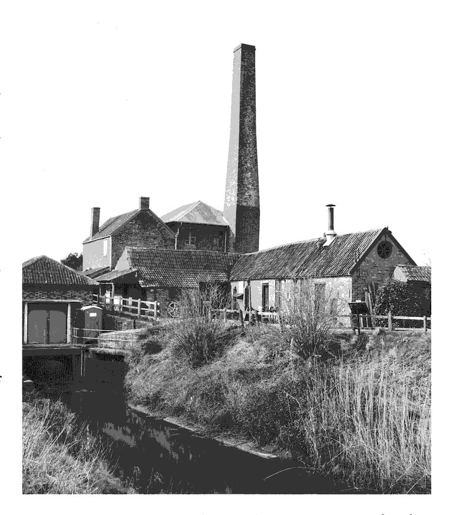
Pumping station at Westonzoyland built in 1861-2
In the 17th century the churchwardens were responsible by means of a special rate for opening and maintaining the clyces, scouring the rhynes and ditches, and mending the river bank with stone. (fn. 314) By order of the Commissioners of Sewers a new watercourse was built c. 1628 in the west of the parish, crossed by two stone bridges. (fn. 315) Although the usual problem was flooding, in 1676 the clyces were opened to admit water during a drought and the wardens paid men to get water to cattle in Sedgemoor and Penzoy. (fn. 316) By the mid 18th century, and probably earlier, responsibility for drainage had passed to the overseers of the poor. (fn. 317) From 1799 separate drainage accounts were kept, not only for maintenance but for watching at night to prevent flooding or malicious damage. In the 1840s individuals were paid a fixed annual sum to maintain clyces out of a special rate. (fn. 318) In 1830 an Act was passed for the drainage of lands between Lake and Burrow walls and between Burrow and Challis walls in Othery. The Othery, Middlezoy, and Westonzoyland Drainage Commission, later Board, set up under the Act, built a beam engine at Modishay clyce, south of the end of Lake Wall, to pump water into the river Parrett. (fn. 319) It had a resident engineer, (fn. 320) but only limited successes in dealing with flooding. In 1843 people had to be prevented from removing earth at Lake Wall. (fn. 321) Following an inspection of the bank and engine in 1860 repair was considered but in 1861 the board installed a drainage machine consisting of a vertical engine and centrifugal pump. In 1863 the drain was ordered to be widened. A horizontal coal-fired boiler was installed shortly before 1914. The 1861 engine was used until 1950 when it was replaced by a diesel-driven pump in an unmanned building on a new channel to the south. The old pumping station is preserved as a museum. (fn. 322)
In the 1860s there were disputes with Chedzoy over drainage to the north-west where a new bank damaged land and prevented flood water from Westonzoyland entering the King's Sedgemoor Drain. (fn. 323) In 1866 the Chedzoy Drainage Board agreed to buy land in Westonzoyland near the clyce at Andersea, about half a mile downriver from the Westonzoyland engine, and installed a draining machine. (fn. 324) A horizontal Lancashire boiler was installed in 1896. (fn. 325) Neither pump prevented severe flooding in 1877 and in the early 20th century. After a period of lack of maintenance the steam pumping stations, including Chedzoy, were abandoned in the late 1940s, and others like Westonzoyland, were replaced by diesel-driven pumps. (fn. 326)
CHURCH
ORIGINS, PATRONAGE AND ENDOWMENT
There was a church by 1189, one of the seven then placed in the immediate jurisdiction of Glastonbury abbey. (fn. 327) It was the mother church of Sowy 'island' with chapels at Middlezoy and Othery. A vicar had been appointed by 1231 (fn. 328) and a permanent vicarage was ordained in 1268, the vicar thereafter being required to find three chaplains and three clerks to serve the mother church and its chapels. (fn. 329) In 1515 the then vicar successfully petitioned that Westonzoyland, Middlezoy, and Othery each became separate parishes. (fn. 330) Westonzoyland was thereafter a sole living until 1984 when it was united with Chedzoy. (fn. 331)
The church was in the patronage of Glastonbury until the Dissolution and passed thereafter to successive lessees of the rectory (fn. 332) until 1744 when the bishop of Bath and Wells excluded the advowson from leases. (fn. 333) Bishops of the diocese have thereafter been pattons of both the vicarage of Westonzoyland and of the united benefice. (fn. 334)
Sowy vicarage was taxed at £8 13s. 4d. in 1291. (fn. 335) Westonzoyland vicarage was assessed at £16 8s 8d. in 1515 (fn. 336) and at £14 6s. 8d. in 1535. (fn. 337) In 1655 the minister was allowed £40 a year, increased to £50 in 1657, (fn. 338) the amount at which the living was valued c. 1670. (fn. 339) In 1760 the living was augmented by a gift of £200 from the patron, Bishop Edward Willes, (fn. 340) and the average net income in the early 1830s was £284. (fn. 341) In 1931 the net value was £520. (fn. 342)
In 1268 the vicar was assigned tithes of young stock, of wool, flax, hemp, cheese, milk, honey, and of all mills save those in the rector's court, small tithes of most gardens and curtilages, all other small tithes and offerings, and the tithes of over 200 a. of land. (fn. 343) Vicarial tithes of Westonzoyland alone were worth over £10 in 1515 (fn. 344) and tithes and offerings £13 9s. 6d. in 1535. (fn. 345) In 1840 the vicarial tithes were commuted for a rent charge of £215. (fn. 346)
The size of the glebe before the ordination of the vicarage is unknown but an acre in the moor was acquired by exchange with Abbot Robert (1171-8) for church land. In 1189 Geoffrey the clerk, probably the rector, also held 13 a. from the manor. (fn. 347) In 1268 the vicar was assigned most of the rector's demesne and most of his tenants. (fn. 348) Some vicarial glebe was exchanged for other land with the manor in 1398. (fn. 349) By 1515 the vicar received £6 8s. 8d. from 57 a. of glebe spread across the whole benefice. (fn. 350) By 1535 the glebe assigned to the vicar of Westonzoyland was worth only £1 10s. 6d. (fn. 351) In 1620 the glebe amounted to c. 64 a. of which c. 24 a. was described as the vicarage manor. (fn. 352) By 1840 there was only 33 a. in the parish but a further 11 a. had been purchased with money from Queen Anne's Bounty, presumably the £200 given in 1760. (fn. 353) In 1844 the vicarial manor (c. 43 a.) was added to the glebe. (fn. 354) Most of the glebe was sold before 1928. (fn. 355)
In 1268 the vicar of Sowy was assigned a house in Othery, which had formerly been the rector's barn and houses for chaplains at Weston and Middlezoy. (fn. 356) A clergy house and the vicar's garden were recorded at Weston in 1308 (fn. 357) and the vicar's chamber called le Cheor, with a born and dovecot, were mentioned in 1387. (fn. 358) A house with two gardens was recorded in 1620. (fn. 359) The same or another house, east of the churchyard, was described as large and ruinous in 1839. It was replaced in that year by a new house on a site to the north-east beside a barn. Designed by Richard Carver, it is a square three-bayed, red brick villa-type house under stucco above a stone plinth with a hipped roof. (fn. 360) It was sold in 1982 and houses were built in the grounds. They included a new vicarge house built in 1981. The old house was renamed Sedgemoor House. (fn. 361)
CHURCH LIFE
William of Bitton (II), bishop of Bath and Wells 1267- 74, was archdeacon of Wells and rector of Sowy in 1263-4. (fn. 362) Adam Wreach was the first recorded vicar of Sowy. (fn. 363) It is not clear whether William Harding was a vicar or a chaplain but in 1329 he was not in orders. Henry Roger, a poor clerk of Lincoln diocese, was presented to Sowy vicarage c. 1333 when only an acolyte but he was a priest when he exchanged his living in 1334. (fn. 364) In 1397 John Preston was allowed to be non-resident for ten years and to let his living, (fn. 365) but he was replaced in 1404 by Henry Abingdon, vicar 1404-36, prebendary of Wells, warden of Merton college, Oxford, and delegate at the Councils of Constance and Basle. (fn. 366) Many 15th- and early 16th-century vicars were graduates. (fn. 367) including Hugh Yng, instituted in 1508, a pluralist and later bishop of Meath and archbishop of Dublin. (fn. 368) The last vicar of Sowy, Roger Church, another pluralist and ecclesiastical administrator, resigned in 1515 when the parish was divided. (fn. 369)
William Croom, vicar 1527-58, was summoned before the Privy Council in 1547 on suspicion of teason. (fn. 370) William Seller, vicar c. 1558-63, was said in 1563 to be of mediocre learning and not licensed to preach. (fn. 371) Francis Godwin, vicar 1587-9, was son of Thomas, bishop of Bath and Wells, a writer of biography and fiction, and later bishop of Llandaff and of Hereford. (fn. 372) Robert Wolfall, vicar 1589-1610, was first non-resident and later accused with his sons of licentious and drunken behaviour. (fn. 373) Anthony Erbury, 1617-29, was said in 1629 not to have read a service for a year. (fn. 374) and Anthony Erbury the younger, vicar 1629-38, was frequently absent, involved in litigation in the Court of High Commission. (fn. 375) Thomas Holt, instituted in 1639, a pluralist and later chancellor of Wells, was deprived in 1646. He was restored in 1660 but the parish was served by curates until 1664 or later. (fn. 376)
In 1737 the vicar and wardens petitioned that the parish had at great expense learnt music and singing but that the singers were dispersed and could not sing in harmony and needed a gallery. One was built in that year. (fn. 377) There was a barrel organ in 1843. (fn. 378) Thomas Alford, a local man instituted in 1768, was also vicar of Ashill. He had 40 communicants c. 1780. (fn. 379) Caleb Rocket, pluralist, prebendary, and master of Bridgwater grammar school, employed his son as curate for £120 a year in 1827. (fn. 380) His successors were resident, holding two Sunday services and celebrating communion eight times a year in 1843 and twice a month by 1873. (fn. 381) In the early 20th century there were two or three Sunday services and the number of Easter communicants rose from 14 in 1929 to 113 in 1953. (fn. 382)
The service of St. Mary in the church was endowed with 4½ a. in Middlezoy let for 8s. 6d. and in 1548 had two chalices and ornaments worth £2 2s. The land was bought by Sir Thomas Dyer in 1554. (fn. 383) In 1558 it was said that in return for funding a priest and ornaments for the brotherhood of St. Mary and for maintaining the church the abbot of Glastonbury had leased a plot of land to the parish for a church house. (fn. 384) A plot 16 ft. by 35 ft. was in the occupation of the churchwardens by 1516 (fn. 385) and may have been enlarged later to build the church house which was let to the parishioners in 1529 for 99 years. In 1600 it was described as built of lias with freestone windows barred with iron and a Cornish tile roof. The upper room had carved timbers and measured 60 ft. by 40 ft. (fn. 386) It may have been used for the parish ale held on the Sunday after Ascension day in 1606 when one of the vicar's sons was elected Robin Hood and sat drinking in the stocks. (fn. 387) In 1634 the building was said to have been used previously as a school. (fn. 388) It was probably the later poorhouse and stood south-west of the road junction near the church. (fn. 389) It was demolished in the mid 19th century. (fn. 390) At that time it had a blocked archway at the west end, a pair of arched doorways, and a number of two-and three-light windows on both floors with two small single lights, possibly quatrefoil headed, on the upper floor. The doors and windows had been altered and chimneys added to create three dwellings. (fn. 391)
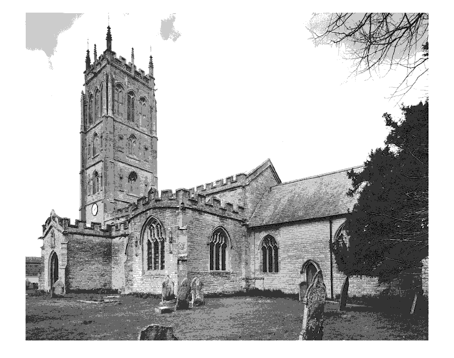
St. Mary the Virgin, Westonzoyland, from the south-east
Former church house of Westonzoyland built by 1529. Later used as school and poorhouse until demolished mid 19th century
CHURCH FABRIC
The church of St. Mary is notable for the exceptional height of its Perpendicular west tower of Quantock type which, together with the whole south front of the church, is richly decorated in Ham stone, and for its nave roof, the most elaborate of its tie-beam type in the county. The tower, nave, and transepts belong to the late 15th-century rebuilding of a church from which the chancel, the 14th-century font, and a late 13th- or early 14th-century effigy of a priest survive. (fn. 462) The two bayed chancel, which has windows with Decorated tracery and shafted rere-arches, may have been built c. 1302-3, when it was being tiled. (fn. 392) Its east window was replaced in the late 15th century. Its north vestry may be medieval in origin but was partly rebuilt in 1778 and altered in 1847. (fn. 393) The nave has wide north and south aisles, which partially embrace the tower and have sixbay arcades of standard local type, a clerestorey, and north and south porches. North and south transepts were added to its east end. The south transept, which has a fine, beamed roof, bears the initials of abbot Richard Bere (1493-1524) on a buttress. RB also appears on the nave roof, in glass, and on bench ends.
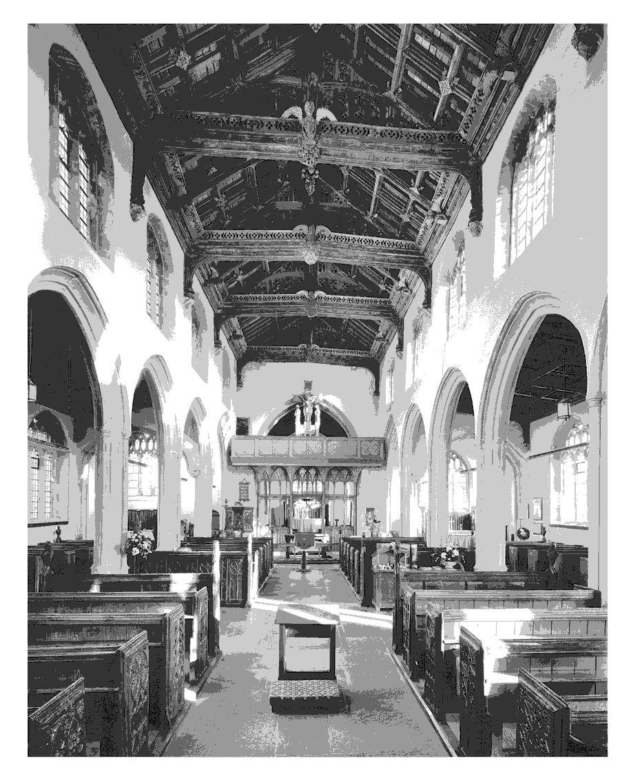
St. Mary's church, Westonzoyland, interior looking east
Significant repairs were made in the 17th century and in the early 19th century. (fn. 394) The gallery built at the west end in 1737 (fn. 395) was demolished c. 1845 and was replaced by a singers' pew. (fn. 396) In the 1860s major work was done under C. E. Giles. (fn. 397) The tower was partially restored in 1907-8 but the rest of the church continued to suffer from settlement. (fn. 398) A national appeal (fn. 399) led to the restoration and refurnishing of the whole church from 1933 under W. D. Caroe, and by 1937 over £8,000 had been spent. Caroe installed a screen in which he incorporated medieval bench ends, a rood, organ case, and seating. (fn. 400) The rood-stair tower was rebuilt, chapels created in the transepts, and heraldic glass and an angel corbel introduced from the Court House site. (fn. 401) Caroe's pulpit stands on the base of one of 1847. In the 18th century a wooden pulpit had a sounding board topped by a flaming urn. (fn. 402) A Jacobean communion table (fn. 403) has been placed in front of the rood screen.
There are six bells, the oldest a medieval one from the Bristol foundry by Thomas Jeffries; two others are of the 18th century by Thomas Wroth and Thomas Bayley. The sixth was added in 1934. (fn. 404) The plate includes a silver chalice of 1573 by 'I. H.' whose cover was repaired in 1682 but was replaced by a paten of 1710 given in 1721. A silver flagon of 1612 was acquired by 1669. (fn. 405) The registers date from 1558 and are complete except for the period 1644-8. (fn. 406)
There was a chapel at the manor house by 1274 (fn. 407) and by 1516 it had glass windows and was decently ornamented. (fn. 408) It may have been the chapel of St. Saviour recorded as a house in 1600 when it was said to have been granted by Christopher Symcocks to the parishioners for a life at 4d. rent. (fn. 409) It has not been traced further.
NONCONFORMITY
A Quaker was living in the parish in the 1670s, (fn. 410) and a house for an unspecified group was licensed in 1699. A house and a backhouse were both licensed for Quaker meetings in 1737. (fn. 411)
Methodist meetings were being held by 1752 and John Wesley preached in the parish in 1768. (fn. 412) In 1790 there were ten members. (fn. 413) A house licensed in 1803 was for occasional use; (fn. 414) it was still in use in 1816 but there were no members. (fn. 415) A revival had occurred by 1837 when there were 70 members, rising to 104 in 1840 when the chapel, formerly in the Taunton circuit, became part of the Bridgwater circuit. (fn. 416) In 1867 there were three Methodist places of worship: one in use by Wesleyans in 1852 and described as a building on private premises; a second described as a Wesleyan Methodist chapel, possibly in Fore Street and in use by 1861; and a third belonging to the Methodist Free Church, opened in Front Street by 1859. (fn. 417) Methodist divisions resulted in falling membership of the original congregation, (fn. 418) but the closure of one Wesleyan society in 1876 (fn. 419) and of the Methodist Free Church c. 1880 was followed by the remaining Wesleyans taking over the former Free Methodist building. (fn. 420) The former Wesleyan chapel in Fore Street closed and was demolished by 1886. (fn. 421) The society had 48 members in 1891 (fn. 422) but in December 1960 there were average attendances of 18 at the morning services and 22 in the evening. (fn. 423) By 1979 there was a morning service once a month and an evening service every Sunday. (fn. 424) In 2000 there was one Sunday service.
There were a few Anabaptists c. 1780 served by a teacher from Bridgwater. (fn. 425) Baptists met at first in a cottage and from 1836 in Ebenezer chapel at Burrowbridge. It was served between 1833 and 1881 first by a minister resident at Othery (fn. 426) and then by one at Middlezoy. (fn. 427) The chapel, on land given by Mrs. Welman of Poundisford, Pitminster, (fn. 428) is of brick under a hipped slate roof. A Sunday schoolroom was added in 1907 over an open stable. (fn. 429) A marriage register survives for 1931-52. (fn. 430)
A house in Westonzoyland was licensed for use by Independents in 1799; (fn. 431) another building used by Protestants was licensed in 1824. (fn. 432) A Congregationalist evangelist began work in 1896. (fn. 433)
EDUCATION
A man kept a school in Westonzoyland in 1619 (fn. 434) and children had been taught in the church house before 1634 when they had been transferred to the church. (fn. 435) Licenses were granted in 1670 to a man to keep a grammar school and in 1682 to a woman to keep an English school. (fn. 436) A charity school for twelve children was said to have been founded in 1774 by the vicar Thomas Alford and endowed by Edward Wynne with £5 a year. (fn. 437) It appears to have ceased by 1819, but 25- 30 children then attended day schools and two Sunday schools, one probably nonconformist, taught 50 children. (fn. 438) One Sunday school, said to have been founded in 1819, and c. 1825 supplied with books by voluntary subscription, (fn. 439) survived with 50 pupils in 1833. By 1833 there were six day schools, all started after 1818, teaching 102 children at their parents' expense. (fn. 440) By 1839, however, there were only three dame schools and 85 children attended a Church of England Sunday school although there was no schoolroom. The same number of children attended in 1847. (fn. 441) A Methodist Sunday school was built on a small site in the northwest of the village in 1840. (fn. 442)
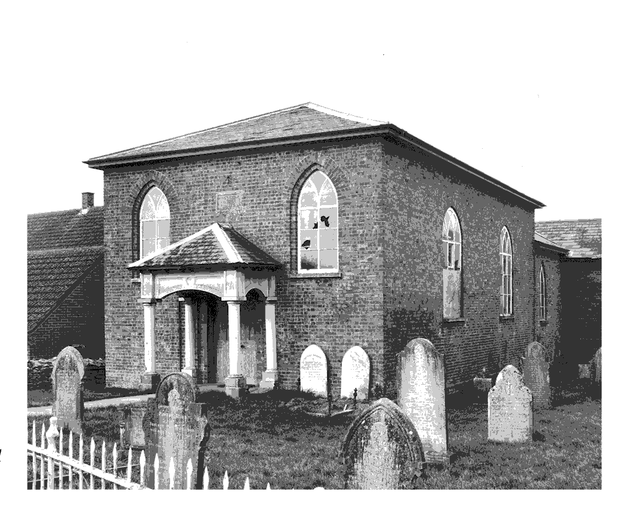
Ebenezer chapel, near Burrowbridge but in Westonzoyland parish, built in 1836 and extended in 1907
A National school was opened in 1842 opposite the church, (fn. 443) and the adjoining pound was acquired to enlarge the site in 1864. (fn. 444) By 1867 100 children attended in winter and up to 40 at night school, attendance in summer was poor, and it was said that uneducated parents were indifferent to their children's education. (fn. 445) William Chapman by his will dated 1868 gave a third of the income from £360 for education. (fn. 446) In 1870 the school was extended to provide two classrooms and an infant gallery and accommodated a total of 148 children. (fn. 447)
A School Board was appointed in 1878 and the National school was transferred to it. (fn. 448) In 1901 a new school for 100 children and 44 infants with a teacher's house was built in Front Street. (fn. 449) The old school, twostoreyed and four-bayed with a hipped roof and Gothic upper windows, was used as a Sunday schoolroom. It was later partly demolished and in 1934 extended as a church hall. (fn. 450) In 1903 there were 135 children on the books taught in three classrooms. (fn. 451) Average attendance fell from 105 in 1905 to 70 in 1915. (fn. 452) The school moved to new premises in the 1950s and new buildings were provided c. 1971. The old school was used by a playgroup in 2000. (fn. 453) In 1955 there were 44 children under 11 on the register, rising to 73 in 1965 and 191 in 1975. There were 184 children at the school in 1998. (fn. 454)
In 1950 a secondary school was opened north-east of the church in buildings formerly belonging to Westonzoyland airfield. (fn. 455) There were 332 pupils in 1952 and 600 in 1961, the year when the school officially closed. Most children transferred to Sydenham school, Bridgwater. The buildings remained in use for a further year for children living outside the Bridgwater catchment area who could not move to Crispin school, Street, until 1962. (fn. 456)
A private day school was recorded in 1861. (fn. 457)
CHARITIES FOR THE POOR
By will dated 1711 Thomas Dibble gave a rent charge of 15s. to the poor, and in 1722 Henry Garrett gave a further £1. Both charities were active in 1915 but have not been found later. (fn. 458) Mary Seymour of Bridgwater (d. 1823) gave £100 in trust for the poor of Westonzoyland. (fn. 459) After 1835 the Revd. Caleb Rocket established a bread charity and in 1847 Elizabeth Axford gave money to provide clothing for the poor. By will dated 1868 William Chapman gave two thirds of the income from £360 and in 1889 Thomas Durling gave an income of £1 8s. 4d. to be distributed amongst eight poor widows. (fn. 460) None of those charities was distributed by the late 20th century and all except the Axford charity were deregistered in 1998-9. (fn. 461)