A History of the County of Essex: Volume 10, Lexden Hundred (Part) Including Dedham, Earls Colne and Wivenhoe. Originally published by Victoria County History, London, 2001.
This free content was digitised by double rekeying. All rights reserved.
'Dedham: Introduction', in A History of the County of Essex: Volume 10, Lexden Hundred (Part) Including Dedham, Earls Colne and Wivenhoe, (London, 2001) pp. 154-161. British History Online https://www.british-history.ac.uk/vch/essex/vol10/pp154-161 [accessed 11 April 2024]
In this section
DEDHAM
DEDHAM, a cloth-working village from the later Middle Ages, was a prosperous small market town by the 16th century. (fn. 1) The ancient parish comprises a roughly rectangular area of 2,568 a. or 1,039 ha. (fn. 2) in the Stour valley, c. 7 miles north-east of Colchester. The western boundary follows the Colchester-Ipswich road, the north- ern the old course of the river Stour, and the eastern a tributary of the Stour earlier called the Shir (shining) burn. (fn. 3) The southern boundary, with Ardleigh, seems to follow a medieval woodland boundary. Since the parish boundary was established, presumably by the early Middle Ages, the main stream of the Stour has shifted northwards, leaving part of East Bergholt (Suff.) on the south bank of the Stour to the east of Dedham village. The only known boundary changes were the transfer of 1 a. from Dedham to East Bergholt in 1933, and another small adjustment of the county boundary in 1989. (fn. 4)
The land rises gently from below 8 m. along the Stour in the north of the parish to c. 38 m. on the flat plateau of Dedham Heath in the south, and to 46 m. at Birchwood in the south- west corner of the parish. (fn. 5) The scarp along the river is slightly steeper in the west of the parish and becomes less pronounced as the Stour valley broadens out towards Judas Gap in the east. The river is tidal as far as Judas Gap, (fn. 6) and before the erection of pumping stations higher up the river by the 1960s the valley was prone to flood- ing. (fn. 7) The Black brook runs from west to east through the centre of the parish, cutting a broad valley which falls to below 15 m. at Brook Farm, then turns north-east to join the Stour near Dedham Hall. (fn. 8)
Meadow along the Stour lies on alluvium, but the town stands on an area of river gravel which extends west, south, and east of the settlement, and land at Gun hill on the western parish boundary is formed of other gravels. The Black brook has exposed gravel, sand, and red crag along its course. Much of the land between the town and Dedham Heath is London clay, and the heath itself is composed of a glacial drift of sands, gravels, loam, and brickearth. (fn. 9) Sand, gravel, and brickearth were exploited commercially between the 16th and 18th centuries. (fn. 10)
In the early Middle Ages the royal forest of Kingswood or Cestrewald extended into Dedham, as far north as Black brook and the later Coopers and East Lanes. The king permit- ted Campsey priory to cut timber there for building works in 1224, 1240, 1246, 1256, 1258, and 1277, and the lord of Dedham Hall to do the same in 1245. (fn. 11) Woodland clearance, which created the open area later known as Dedham Heath, was still incomplete in 1329 when the great wood on Dedham Hall manor was worth nothing because it lay within the king's forest. (fn. 12) The heath, first recorded in 1412-13, (fn. 13) was divided into several parts, including one called Randes Heath in 1615, perhaps the later Purney Heath north of Birchwood. (fn. 14) When the heath was inclosed c. 1800 it comprised c. 1,000 a. from Stour House in the south-east of the parish to beyond Lamb corner in the south-west. (fn. 15)
The park on Dedham Hall manor from which horses were stolen in 1668 may have been at or near the later Park farm. (fn. 16) It presumably sur- vived c. 1720, when men were accused of break- ing the park. (fn. 17) The landscape, with its views of the Stour valley and estuary, favoured the estab- lishment of country houses with ornamental parks, gardens, and pleasure grounds, and prob- ably influenced the siting of high status 18th- and 19th-century houses. There appear to have been small parks or gardens at the Rookery (later Dalethorpe) and The Grove in 1777, others at Hill House, Stoneylands, and Lower Park by 1841, and others at Hillands, Upper Park, High- lands, and Stour House by 1875. (fn. 18)
The landscape provided the inspiration for the paintings of John Constable (1776-1837), whose work made Dedham Vale famous. Constable, from East Bergholt (Suff.), was educated at Dedham grammar school, where his father had milling interests. Many of his paint- ings and drawings portray views from Langham woods and Gun hill, often with Dedham, its church and its mill, in the background. (fn. 19) From the late 19th century Constable's growing fame attracted other artists to what became known as Constable's country. (fn. 20) Chief among them was Sir Alfred Munnings, who lived at Castle House, Dedham, from 1919 until his death in 1959. (fn. 21) Tom Keating, the artist and faker known for his 'copies' of old masters, worked in Dedham in the later 20th century. (fn. 22)
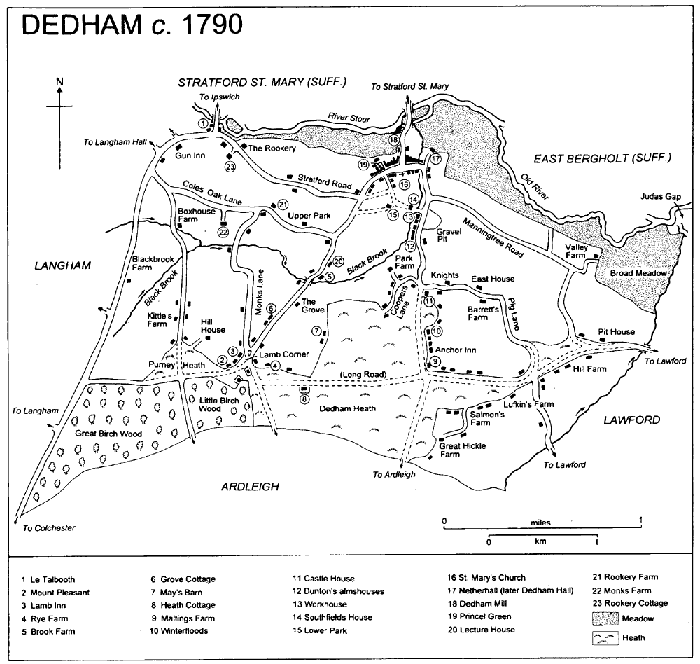
Dedham c. 1790
In 1937 the parish council discussed the pres- ervation of historic buildings, (fn. 23) and the follow- ing year the Dedham Vale Society was formed to 'maintain, protect and enhance the natural, architectural and other amenities of the Vale'. Among the 90 founding members were Sir Alfred Munnings and the architect Raymond Erith, who was the first chairman. By 1988 the membership had grown to 500, and the society was an effective lobbying force. (fn. 24) In 1970 the Countryside Commission confirmed the Vale, including most of Dedham, as an Area of Out- standing Natural Beauty. (fn. 25) The National Trust acquired land in the parish from the 1940s; by 1992 it owned over 300 a. at Bridges and Lower Barn farms. (fn. 26)
ROADS AND WATERWAYS.
The medieval Colchester-Ipswich road largely followed the line of the Roman road from London to Caistor St. Edmunds (Norf.). At Gun hill the medieval road turned eastwards to negotiate the scarp, crossing the Stour near the modern Stratford bridge. The Roman road may have followed that route, or may have run through Langham woods and crossed the Stour further west. (fn. 27) The road was turnpiked in 1725; (fn. 28) the toll house, at Strat- ford bridge in 1841, was demolished in the earlier 20th century. (fn. 29) A new road from Gun hill, by-passing Dedham and Stratford St. Mary, opened in 1966. (fn. 30)
The route from Dedham to Stratford St. Mary, along Mill Street and over Dedham bridge, may have replaced an earlier one by a ford at the northernmost bend of the Stour. (fn. 31) Another route ran roughly parallel to the Stour from Stratford bridge to Dedham High Street and thence to Causeway End Farm, Lawford. (fn. 32) In 1523 John Webb left money to repair the highway between Stratford bridge and Dedham church. (fn. 33) Routes from Dedham to Colchester via Ardleigh ran from the east and west ends of High Street through Dedham Heath and Lamb Corner. One, apparently later known as the king's way, perhaps existed by 1249. (fn. 34) Lesser roads and tracks, leading to farms, woods, and meadows, are probably also medieval. Hay Street or Lane was recorded in 1386 and 1545, (fn. 35) and Long Street, possibly the later Long Road, in 1386. (fn. 36) Coopers Lane and East Lane (Pig Lane until the 20th century) probably originated as woodland droveways. (fn. 37)
Stratford bridge was first recorded in 1441. (fn. 38) Thomas (d. 1506) and John (d. 1523) Webb both bequeathed money for the repair of the great bridge at Stratford St. Mary. (fn. 39) St. John's chapel recorded in 1523, which stood just south of the bridge, may have been a bridge chapel; it was demolished in 1826. (fn. 40) In 1614 the bridge was decayed and in danger of being destroyed by floods. (fn. 41) Repairs, in timber, were made in the 1660s. (fn. 42) Essex and Suffolk were jointly liable for repairs, and c. 1787 a new bridge was built by the Essex county surveyor, John Johnson. That bridge was swept away in 1795, and the following year Johnson built a new, wooden bridge with brick abutments at either end, on a site 70 ft. east of the old crossing. In 1875-6 Johnson's bridge was replaced by an iron bridge. Another replacement was built in 1928. (fn. 43)
The bridge built by the churchwardens before 1548 with some of the proceeds of the sale of church plate (fn. 44) may have been that over the Stour at Dedham mill, or the footbridge recorded in 1596. (fn. 45) The footbridge and causeway at the mill were repaired jointly by the mill owner and the parish in 1797. (fn. 46) In 1841 the bridge was altered by the Stour Navigation Co. In 1899 Essex and Suffolk County Councils took over the bridge, (fn. 47) and rebuilt it with iron girders in 1900. That bridge was replaced by a concrete one in 1974. (fn. 48)
The long bridge recorded in 1559 was possibly that to East Bergholt (Suff.) recorded in 1580. (fn. 49) In 1821 Essex County County declined to repair a footbridge to East Bergholt, (fn. 50) and later in the century there were two such bridges. (fn. 51) Another footbridge was built after 1839 on the site of the ford north-east of Ded- ham Hall. (fn. 52) A wooden footbridge from Dedham to Flatford (Suff.) was built in 1985 to replace an earlier, collapsed, bridge. (fn. 53)
Although there is no clear evidence for early shipping on the Stour, Dedham sent ships to the Icelandic fishery in the early 16th century. (fn. 54) The River Stour Navigation Co. made the river navigable between 1705 and 1713, and the lock at Dedham mill was rebuilt many times in the later 18th century and the 19th. The company went into voluntary liquidation in 1913, but the South Essex Waterworks Co. rebuilt the lock in 1928 and the river was used sporadically until 1931. (fn. 55) The River Stour Trust started to repair the navigation in 1975. (fn. 56) A wooden staunch was built at Stancks meadow before 1817 to hold back water and deepen the channel at the ford; its remains were still visible in 1937. (fn. 57)
POPULATION AND SETTLEMENT.
The re- corded population, of free and unfree tenants and servi, declined from 35 in 1066 to 32 in 1086. (fn. 58) In 1377 a total of 254 people paid poll tax. (fn. 59) Many new Colchester burgesses were migrants from Dedham in the period 1381- 1560. (fn. 60) Baptisms exceeded burials between 1560 and 1587, but only by 20 per cent, suggesting little growth. (fn. 61) Between 1597 and 1671 the number of households apparently increased from 200 to 265, (fn. 62) despite emigration to the New World particularly in the period 1630-9. Four members of the prominent Sherman family were among the emigrants, (fn. 63) as was Edmund Angier, one of the first settlers in New Eng- land. Dedham, Massachusetts, was named by Dedham settlers c. 1635. (fn. 64)
In 1686 the population was said to be more than 2,000; (fn. 65) it was apparently maintained by immigration as burials exceeded baptisms by 20 per cent in the periods 1641-54 and 1681-99. (fn. 66) Plague broke out in 1666, (fn. 67) and in 1724 smallpox killed 106. (fn. 68) There were further outbreaks of smallpox in 1750 and 1759, and fear of the disease led to the cancellation of Dedham fair in 1773 and 1785. (fn. 69) In 1723 there were said to be only 100 families in the parish, probably an underestimate as 300 houses were reported in 1778. (fn. 70) The population grew from 1,537 in 1801 to a peak of 1,916 (including the 114 staff and pupils at the grammar school) in 1871, (fn. 71) then fell to 1,500 in 1901. (fn. 72) It remained relatively stable until 1971, when it stood at 1,641, and had risen to 1,824 in 1991. (fn. 73)
Scattered neolithic material, including axes, has been found in Dedham, (fn. 74) but the earliest evidence of settlement are the Bronze-Age ring ditches, cremations, and enclosures found east of the town on ground overlooking the Stour. (fn. 75) An enclosure at Lamb Corner may be Iron- Age, (fn. 76) and crop-marks at Purney Heath, where a probably Romano-British stone figure of an infant has been found, may mark further prehis- toric activity. (fn. 77) Another enclosure near the Bronze-Age settlement contained late Iron-Age and early Roman material, as did a site at Jupes Hill farm. (fn. 78) Glass and a tessellated pavement, possibly from a villa, were found north of Man- ningtree Road, near the river. (fn. 79)
The medieval settlement pattern comprised a single nucleated village with an associated open field system, and scattered farms elsewhere in the parish. Dydda's ham or hamm referred either to that settlement, presumably on the site of the later High Street which is close to a ford over the Stour, or to the extensive meadows along the river. (fn. 80) Most of the village's medieval houses were on High Street east of Princel Green; they may have been planned with regular tenements stretching north to a back lane but the topographical evidence is late and uncertain (fig. 28). Surviving houses in Mill Lane and on Princel Green indicate some medieval settle- ment beyond High Street. (fn. 81) Houses to the south-east on later Crown Street, including Southfields, were probably built after the leas- ing and piecemeal inclosure of common-field land in the later 14th or 15th centuries. (fn. 82) Farms on the rising ground towards the heath, with their own irregularly-shaped fields, were probably medieval assarts. Towards the western parish boundary, Dalethorpe, Boxhouse Farm, Rookery Farm, The Rookery, and Le Talbooth, were all standing by the 16th century. (fn. 83) Other houses were built at road junctions like Lamb Corner and Jupes Hill, and along heath-edge tracks like Coopers Lane and East Lane. The 14th-century Winterfloods House, Rye Farm, perhaps named for Matthew atte Ry (1389), and the tenement next to the heath recorded in 1412-13, indicate that the pattern is medieval. (fn. 84) Farms south of Long Road, such as Lufkin's and Heath (formerly Salmon's), and the Old and New Hickle, were probably the final stages of medieval colonisation. (fn. 85)
By c. 1793 Dedham's reputation as a 'genteel neighbourhood' was reflected both in the re- building and modernization of houses and shops in High Street, and in the construction of country houses. (fn. 86) The latter were not built for manorial lords or great landowning families; the vicar reported in 1767 that the parish had 'several gentlemen of easy fortune, but no family of note'. (fn. 87) After the construction of the Great Eastern Railway in the 1840s, however, the parish, which had no station, gradually became a social backwater. (fn. 88) A few large houses were built, but most new mid and later 19th-century buildings, such as Princel, Duchy, and Octagon Houses, were smaller. (fn. 89)
In 1671 as many as 95 out of the 151 house- holds paying hearth tax had only one hearth, and another 114 were exempt. (fn. 90) Most of those dwellings were probably in hamlets at Coopers Lane, East Lane, Purney Heath, Lamb Corner, and Anchor Corner on the heath, where most 19th- century labouring and artisan families lived. (fn. 91) The buildings were either small, timber-framed or brick lobby-entry cottages, (fn. 92) or sub-divided medieval farmhouses. (fn. 93) Other poor families lived near the almshouses, in the former workhouse (Whitmore Place) and Southfields, which between them housed 112 people in 1851. (fn. 94) In 1900 there were more than 200 cottages, (fn. 95) which in 1902 were overcrowded and in poor condition. (fn. 96) Many were demolished and replaced by the Crown Fields council estate, built after the First World War and extended in the 1920s. (fn. 97) More council houses, some of them Airey concrete houses, were erected after the Second World War, (fn. 98) and others built at Forge Street and Bargate Lane in the later 20th century. (fn. 99)
Private development peaked in the 1960s. (fn. 100) The parish council tried to confine new develop- ment to the heath, (fn. 101) where there were in 2000 a mixture of 19th- and 20th-century houses, chalets, and bungalows. The Dedham Vale plan of the late 1960s stipulated that agricultural land should not be built on, (fn. 102) and new houses have since been obtained by rebuilding on old sites, by infilling, and by converting industrial build- ings, such as Dedham mill in 1987 and a former tallow or candle factory in 1992. (fn. 103)
SERVICES AND TRANSPORT.
In 1559 the common brook, presumably the Black brook, provided drinking water. (fn. 104) About 1895 the public had access to an artesian well at Dedham grammar school, but in general the water supply in the earlier 20th century was poor. (fn. 105) By 1909 Lexden and Winstree R.D.C. had built a sewage treatment works east of Dedham mill. (fn. 106) The Tendring Hundred Waterworks Co. built Dedham pumping station near Bridges Farm before 1936. The single-storeyed, white brick building, with round headed windows, was still in use in 2000. (fn. 107)
Dedham Gas, Light, Coke and Coal Co. was established in 1861 with 16 subscribers; all but one from Dedham. (fn. 108) A gas works was built before 1863, (fn. 109) east of Dedham mill, (fn. 110) and the town was lit by gas in the 1890s. (fn. 111) The company went into voluntary liquidation in 1923. Its replacement failed between 1929 and 1933. (fn. 112) A new gas supply was provided for the village and the heath after 1989. (fn. 113) Colchester Corporation supplied electricity from 1932. (fn. 114)
In 1768 two London coaches travelled to Ipswich through Dedham, (fn. 115) and others, including the Norwich mail, served the parish in the late 18th century and the early 19th. (fn. 116) There was a Post Office by 1838. (fn. 117) About 1793 a wagon from Stowmarket to London called at the Marlborough Head once a week, and there was a regular carrier's service to Colchester twice a week. (fn. 118) Several carriers operated services to Colchester, Ipswich, and Ardleigh in the later 19th and earlier 20th centuries. (fn. 119) Beeston and Sons Ltd. ran a motor bus service between Colchester and East Bergholt through Dedham from 1917. Among other services, one run by the National Omnibus and Transport Co. Ltd. in 1920 was extended to the heath in 1930. (fn. 120) Eastern Counties operated a service to Colchester in 2000.
SOCIAL LIFE.
In 1579 three men were licensed to keep a victualling house. (fn. 121) The house licensed for George Bigges in 1587 and 1589 may have been Southfields, which Bigges leased from 1583. (fn. 122) Further alehouse licences were granted in 1589, 1592, and 1600, (fn. 123) and by 1608 there were probably five inns. (fn. 124) Disorderly houses were closed c. 1604 and in 1721. (fn. 125) An inn on the Colchester-Ipswich road in 1728 (fn. 126) may have been the Gun, first recorded in 1698, (fn. 127) or the 'Shiers' on Dedham hill, said to have opened c. 1690. (fn. 128) A house called the Admiral Vernon in 1743 (fn. 129) was one of seven inns recorded in 1762; the others being the Marlborough Head, the Sun, the Three Compasses or the Compasses, the Rose and Crown or the Crown, the Anchor, and the Gun. (fn. 130) The Admiral Vernon was not recorded again, but the others apparently con- tinued throughout the 19th century. The Lamb opened before 1841, and two beerhouses, the Prince of Wales on Coopers Lane and the Live and Let Live on Ardleigh Road, before 1861. There were three other beerhouses in 1863. (fn. 131)
The Dedham Church of England Temperance Society, recorded in 1882, (fn. 132) apparently had little effect on the number of drinking houses, for in 1895 there were still 10 inns and beer- houses, about one for every 150 inhabitants. (fn. 133) The Compasses closed in 1911, (fn. 134) and The Prince of Wales and Live and Let Live perhaps in the earlier 20th century. (fn. 135) The Gun closed in 1967, and the Lamb in 1998. (fn. 136) The Marlborough Head, the Sun, the Rose and Crown, and the Anchor were still open in 2000.
A society for the protection of property against arson and robbery, formed in 1824, met at the Marlborough Head or the Sun. (fn. 137) The Dedham Society for Brotherly Love met at the Marlborough Head from 1761 until 1912, (fn. 138) and nine other friendly societies met at Dedham inns between 1794 and 1850. (fn. 139) The penny bank at the Congregational church in 1882 was presumably a savings scheme or benefit society. (fn. 140) In 1887 the Tendring Hundred Provident Society had 65 Dedham members, (fn. 141) and another provident society, the Dedham British Society, held copyhold land between 1831 and 1892. (fn. 142) The Dedham Slate Club, a working men's insurance and savings club, was founded in 1908; its mem- bership declined from 150 in 1910 to fewer than 40 by 1922. (fn. 143) Later 19th-century clothing club and boot clubs were funded by subscriptions. (fn. 144) The Dedham Nursing Association, founded in 1902-3 to support a parish nurse, continued in 1966. (fn. 145) The Grove was bought by Essex County Council and converted to an old people's home in 1953; it closed in 1990. (fn. 146)
The number of gentle and professional families in Dedham and its environs encouraged the foundation of societies like the music society recorded in 1739. (fn. 147) The Dedham Assembly Rooms had opened by 1745 when a concert and a ball were held there, and the assembly was recorded in 1747-8. (fn. 148) Dances were held during the two-days Dedham fair in 1760, (fn. 149) but in 1769 subscriptions were collected to repair the building and establish an assembly there for three years. (fn. 150) Three private subscription balls were held each winter until 1840, but only 40 people attended the single ball in 1852. The assembly room had closed by 1882, and was later used as a furniture store. (fn. 151) W. W. Hewitt of Lower Park bought the building and restored it as a parish hall and reading room in 1908. (fn. 152) Called the Hewitt Memorial Hall, it has since been used for church events, lectures, plays, and concerts. (fn. 153) It is a timber-framed and rendered hall of c. 1744, originally with a portico facing the road. Single-bayed extensions on the north-east and south-west were lengthened in the mid 19th century. The interior has a shallow arched ceiling, a contemporary gallery with vase-shaped splat balusters, and a chimneypiece with an eared architrave. A major restoration was completed in 1999 with a grant from the Heritage Lottery Fund. (fn. 154)
In the later 19th century the National school- room was used for lectures, concerts, and enter- tainments. (fn. 155) A literary Institute, formed in 1853, which had a reading room by 1863 and a librarian by 1871 is not recorded thereafter, (fn. 156) but may have been the parish library with 500 volumes in the National schoolroom in 1887. (fn. 157) It was still open in 1904, although the books were a bit worn. (fn. 158) The Dedham Working Men's reading room, at the Assembly Rooms in 1890, moved to the new village club and reading room built in 1893 north of Southfields House. (fn. 159) The clubhouse was leased to the British Legion from 1920, and housed both village and ex-service- man's clubs until 1967. (fn. 160) Dedham muniment room, in the church tower, was created in 1938 to house G. H. Rendall's gift of books, maps, and manuscripts to the parish. (fn. 161)
In the later 16th century the parish leased an archery ground, Shooting Piece or Arrow Ground, (fn. 162) and between 1616 and 1689 it received the rent of 3 a. in Camping Close, pre- sumably a football ground. (fn. 163) Both pieces of land were in private possession in 1809, and probably long before that. (fn. 164) Horse races were held on the heath in 1726 and 1729. (fn. 165) Later sporting clubs included the quoit club, which met until 1914, (fn. 166) the cricket club revived in 1885, 1892, and 1920, (fn. 167) the football club recorded in 1899 and refounded in 1910, (fn. 168) and the tennis club re- corded from 1910. (fn. 169) The football and cricket clubs used the Duchy barn, converted by W. W. Hewitt, as a pavilion. (fn. 170) In 1896 the parish created a bathing place at Sweetman's meadow on the Stour; it closed in 1906. (fn. 171)
In 1943 the parish bought the cricket ground, (fn. 172) and five years later obtained a long lease of the Duchy field as a children's play- ground. (fn. 173) Football, hockey, rugby, tennis, and croquet were played in the later 20th century. (fn. 174) The tennis club closed c. 1960, but had reformed by the early 1990s. (fn. 175) A new sports pavilion was built c. 1970, (fn. 176) and in 1976 a further 1½ a. of land was given to enlarge the playing field. (fn. 177)
A village band formed in 1899 continued in 1906; (fn. 178) the Dedham Folk Dancers performed in the 1920s, (fn. 179) and the Dedham Arts Group exhib- ited in 1983. (fn. 180) The Dedham Players, founded in 1970, were still producing plays in 2000. (fn. 181) An annual flower show was held in Lower Park in 1903, (fn. 182) and there was a Horticultural Society in 1983. (fn. 183)
Dedham was a fashionable holiday place from the 1890s, (fn. 184) and the cycle agent recorded in 1898 and the refreshment room in 1912 presumably reflected increased tourism. (fn. 185) In 1901 the Great Eastern Railway arranged day trips from Liverpool Street station to Constable's country, with lunch at Dedham. (fn. 186) A holiday camp was advertised in 1933, and the Talbooth was a restaurant by 1937. (fn. 187) Dedham boatyard hired out rowing boats and canoes in the later 20th century. (fn. 188) The Heavy Horse Centre opened c. 1976 but closed before 2000. (fn. 189) Dedham Rare Breeds Centre opened in 1991. (fn. 190) The Council for the Protection of Rural England ran a tourist information centre from c. 1973 to 1999. (fn. 191) Since 1960 c. 20 a. of land has been taken for car parks and other tourist facilities, including the large car and coach park built on Mill Lane c. 1991. Such changes have provoked concern about possible overcrowding, congestion, and inap- propriate development. (fn. 192)
NATIONAL EVENTS.
In December 1381, in the aftermath of the Rising, the tenants of Faites and Wades manor made a formal submission at its court that they held their tenements from their lord for rents and services. (fn. 193) In 1450 Sir John Fastolf's Dedham property was damaged, and his fish and swans poached, by adherents of the duke of Suffolk. (fn. 194) A Dedham saltpetreman in the service of the earl of Warwick was pillor- ied in Colchester in 1579 for insulting the earl of Oxford, (fn. 195) and in 1580 a Dedham surgeon and a clothier were among those arrested for sup- porting the royal impostor Robert Mantell. (fn. 196) Soldiers were billeted on the parish in 1627-8 and again in 1640. (fn. 197) The parish, led by the lecturer John Rogers, was among those which opposed the forced loan, and later the ship money, raised by Charles I. (fn. 198) Two Dedham puritan clothiers were arrested in London when their outspoken views against royal policy led to a tavern brawl. (fn. 199) Dedham men supported the parliamentarian army during the siege of Colchester in 1648. (fn. 200) The Dedham Volunteers, recorded in 1802, were re-formed in 1803 as the Loyal Dedham Volunteers, and disbanded in 1808. (fn. 201) Dedham men dominated the 13th Company ('Stour valley') Rifle Corps, raised in 1860. (fn. 202)