A History of the County of Essex: Volume 10, Lexden Hundred (Part) Including Dedham, Earls Colne and Wivenhoe. Originally published by Victoria County History, London, 2001.
This free content was digitised by double rekeying. All rights reserved.
'Stanway: Introduction', in A History of the County of Essex: Volume 10, Lexden Hundred (Part) Including Dedham, Earls Colne and Wivenhoe, (London, 2001) pp. 259-263. British History Online https://www.british-history.ac.uk/vch/essex/vol10/pp259-263 [accessed 11 April 2024]
STANWAY
STANWAY lies immediately west of Colchester borough, into which it was incorporated in 1974. (fn. 1) The ancient parish (3,436 a. or 1,391 ha.) was bounded on most of the south and west by Roman river, on part of the east by the Iron- Age Grymes Dyke, and on the south-east by the road from Colchester to Layer-de-la-Haye. The northern boundary, which mainly followed field boundaries, was disputed in places as late as 1817. Until 1883 there were two detached areas of Stanway (105 a. and 3 a.) in Copford. (fn. 2) In the Middle Ages there were detached portions within Colchester borough, including one around St. Cross chapel or hospital in Crouch Street and Maldon Road, and one near the south-west postern; both were absorbed into the surrounding St. Mary's parish in the 15th cent- ury or the early 16th. (fn. 3)
In 1292 Colchester claimed before the forest justices that Stanway was within the borough; the grant of a rent in Stanway and Copford was enrolled in the Colchester court in 1346, and as late as 1578 at least part of Stanway was within the liberties of Colchester. (fn. 4) In the late Middle Ages 'Olivers fee', possibly Olivers manor in Stanway, was within the borough. (fn. 5)
In 1086 Lexden was claimed by both Col-chester and Stanway, and 1½ a. on the boundary between Stanwayand Lexden was in dispute in 1416. (fn. 6) Gosbecks, in the south-east corner of Stanway, was said in 1414 to be in the Head ward of Colchester, and a dispute over fields belonging to Gosbecks farm was heard by the borough court in 1427. (fn. 7) The boundary between Stanway and St. Mary's parish, Colchester, east of Gosbecks, was still uncertain in the earlier 18th century. (fn. 8)
In 1934, under the Essex Review Order, 428 a. at Shrub End and Gosbecks was trans- ferred to Colchester. Under the County of Essex Confirmation Order of 1949, 96 a. between the railway and the London road, formerly in Copford, was added to Stanway, and 125 a. north of the railway, formerly in Stanway, became part of the new civil parish of Eight Ash Green; 47 a. south-west of Roman river was transferred from Stanway to Birch. (fn. 9)
Most of Stanway lies on glacial sand and gravel, but the underlying London clay is exposed between Bellhouse farm and Roman river near the western boundary, and near Olivers to the south-east. There is a narrow strip of alluv- ium along Roman river. (fn. 10) The land rises from 9 m. at Kingsford bridge and 23 m. at Stanway bridge, in the Roman river valley, to 37 m. at Stanway green and 41 m. at King Coel's kitchen in the north-east quarter of the parish. (fn. 11)
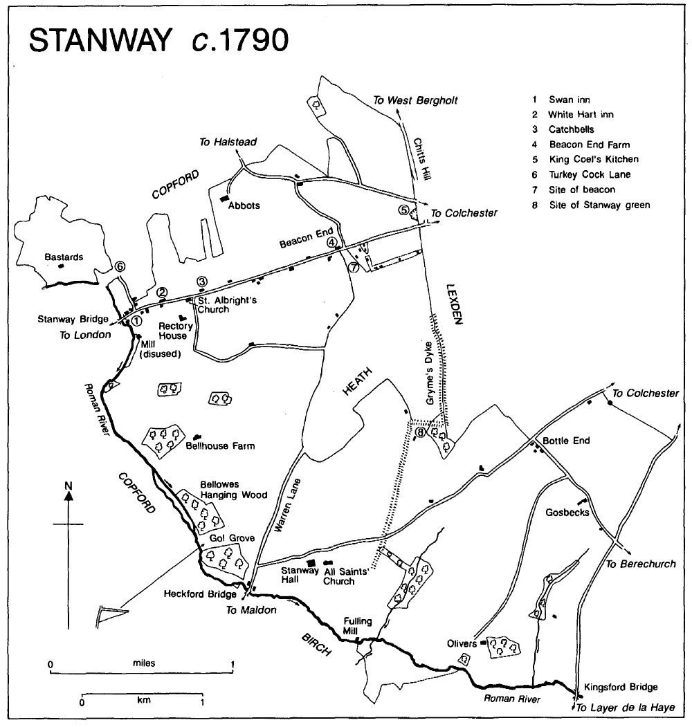
Stanway c. 1790
The main London to Colchester road, turnpiked in 1696, (fn. 12) runs across the northern edge of the parish. By 1966 the road was so busy that it was said to divide the village like a Berlin wall, and the A12 bypass north of Stanway was opened in 1971. (fn. 13) The Colchester to Halstead road, turnpiked in 1765, (fn. 14) cuts across the north- eastern corner of the parish. The Colchester to Maldon road crosses the parish from east to west, and the Colchester to Layer road, called Stirupp Lane in 1634 when the inhabitants of Stanway and St. Giles's Colchester were respon- sible for its repair, (fn. 15) forms the south-eastern boundary. Warren Lane runs from the Maldon road in the south-west corner of the parish across the former Stanway heath to Beacon End in the north-east quarter. Chitts Hill, called Hull lane in 1724 and 1775, (fn. 16) connects the parish with West Bergholt, and Turkey Cock Lane, so named in 1775, (fn. 17) with Aldham.
The London road crosses Roman river by Stanway bridge, called Elpeford bridge in 1272 and Emperford or Stanway bridge in 1580. (fn. 18) It was a footbridge in 1808, (fn. 19) but the surviving single-arched, brick bridge appears to have been built soon afterwards. The repair of Heckford bridge, by which the Maldon road crosses Roman river, was the responsibility of the lord of Stanway manor in 1615 and the joint re- sponsibility of the lord of Easthorpe with Birch and the owner of Stanway Hall in 1826. (fn. 20) It was still a wooden footbridge in 1880. (fn. 21) The modern concrete structure encases a late 19th- or early 20th-century two-arched brick bridge. Kings- ford bridge over Roman river, on the Layer road, was rebuilt by the county council in 1891. (fn. 22)
Scattered palaeolithic, mesolithic, and neolithic tools have been found in the parish. The earliest evidence for settlement is provided by cropmarks associated with a Bronze-Age cem- etery at Chitts Hill, and at Gosbecks. (fn. 23)
Gosbecks was within the Iron-Age Camulo- dunum, protected on the west by Grymes, Kid- man, Heath Farm, and Layer dykes. Its large farmstead was one of the centres, perhaps a royal centre, of settlement. The importance of its market is indicated by the fine bronze statue of Mercury, god of commerce, discovered there. In the mid 1st century a small Roman fort was built in a corner of the site, and later in the century a temple, a theatre, and a bath house were added, forming a large tribal sanctuary. Outside the dyke system, west of Gosbecks, was the burial place of the native aristocracy of Camulodunum, which continued in use after the Roman conquest. The four main cremation burials had been made in wooden mortuary chambers within large enclosures, a practice otherwise known only at St. Albans. Grave goods from the few secondary graves within the enclosures included a spear, an inkpot, and a set of surgical instruments, suggesting their occupants may have been officials of those buried in the chambers. Another cemetery at Gosbecks was in use in the 4th century. (fn. 24)
Three hoards of late 3rd-century coins found at Olivers Orchard, south of Gosbecks, suggest settlement in that area. (fn. 25) Several confused re- ports appear to relate to a villa at Stanway green, and cropmarks between London Road and Bellhouse Farm may mark other Roman build- ings. Scattered Roman finds have been made elsewhere in the parish. (fn. 26) The Roman road from London to Caister St. Edmunds (Norf.) and Stane Street ran through the northern edge of Stanway on the same lines as the later London and Halstead roads. (fn. 27) A minor road joined Gosbecks to Colchester and may have continued westwards. (fn. 28)
Early Anglo-Saxon pottery has been found in Gol Grove, in the Roman river valley near Stanway Hall. (fn. 29) In the 10th century, when Stanway was part of a large estate held by the ealdor- men of Essex, (fn. 30) the later parish was divided between two estates, Berton and Stanway. The first element of Berton is probably 'burh', a fort, and the name may mean 'settlement of the fort'. (fn. 31) Although there is no independent evidence for one, a fort at Berton would have commanded the western approach roads to Colchester. The estate included the land between the London and Halstead roads, and field names suggest that it may have extended along both sides of the London road as far west as the later Church Lane. (fn. 32) If it did, St. Albright's church, dedicated to St. Ethelbert of East Anglia (d. 794), which was later a chapel of Stanway, (fn. 33) might have been its church. Stanway, 'at the stone tracks', presumably took its name from the Maldon road, which runs by its main manor house and parish church, and other old roads in the southern half of the parish. (fn. 34) Berton came to be called, or was absorbed into, Little Stanway in the course of the 12th century. (fn. 35) The division of the parish into Great and Little Stanway con- tinued until the later 16th century. (fn. 36)
In 1066 Stanway manor had a recorded popu- lation of 40; no tenants were recorded at Berton. (fn. 37) Stanway was one of the more sparsely populated parishes in the hundred in 1377 when only 99 people paid poll tax, and the population may have fallen by 1426 when there were 10 ruined houses on Stanway manor. (fn. 38) In 1671 thirty-one households were assessed for hearth tax, four of them on empty houses, and 16 were exempt by poverty. (fn. 39) Burials equalled or ex- ceeded baptisms in most years between 1704 and 1730 and between 1762 and 1770, but the population grew slightly. (fn. 40) Rectors reported 55 houses in 1766, 31 houses and 27 cottages in 1778, and c. 60 houses in 1790. (fn. 41) The population in 1801 was 422. It rose throughout the 19th century, except in the period 1861-71, reaching 1,107 in 1901, including 124 people in the Lexden and Winstree Union workhouse. (fn. 42) It increased more quickly in the early and mid 20th century, reaching 2,426 in 1961, in an area which excluded the suburb of Shrub End, taken into Colchester in 1934. By 1971 the population had almost doubled, to 4,505, most of the growth having taken place before 1967, and by 1991 it was 7,563. (fn. 43)
Settlement was scattered until the 19th century; in 1790 the rector reported that there was no village or hamlet in the parish. (fn. 44) By 1787 there were several houses round Swan green at Stanway bridge, most of which survive. (fn. 45) As well as the Swan inn, which retains its 18th- century core, they included nos. 368 and 370 London Road, a late 15th- or early 16th-century house comprising a hall and cross wing; the late 17th-century Street Farm; Vine Cottage and no. 366 London Road, a 15th-century hall house with two cross wings; and the late 15th-century Sparrow Hall in Turkey Cock Lane, which by 1787 was in Copford parish. (fn. 46)
Other early houses stand along London Road. The former White Hart inn, Stanway Garden Centre in 1995, is a hall house with two cross wings. The east wing and perhaps the hall were built in the 14th century, the surviving west wing in the early 16th century. In the 17th century a floor was inserted in the hall and the roof renewed. The house, which apparently owed a quit rent to the rectory manor, (fn. 47) may have been the house called the Hart conveyed by John Jobson to Edward Jobson in 1579. (fn. 48) A few yards east of St. Albright's church is no. 296 London Road, called the Cedars in the 19th century, earlier Knatchballs, Catchbells, or Peverels. It has an early 15th-century east wing with a crown-post roof; the hall was originally of the same date, a first floor being inserted in the late 16th century. The west wing was built c. 1500. It was occupied by a freeholder, Caleb Pilgrim, in 1637, and was taxed on six hearths in 1671. In 1774 it was the main house on an estate of 136 a. in Stanway and Copford. (fn. 49) Beacon End Farm, (fn. 50) further east on London Road, is another 14th-century hall house with two cross wings; the west wing retains a 16th-century crown-post roof. The house was refronted in brick in the 18th century, perhaps by the Round family who owned it by 1775.
Stanway Hall and the ruined All Saints' church lie on the south side of the Maldon road, near Heckford bridge, and the other manor house, Olivers, lies c. ½ mile to the south-east, on the edge of the Roman river valley. Midway between Stanway Hall and London Road is Bellhouse Farm, recorded from 1393, (fn. 51) although the surviving timber-framed and weather- boarded house is of c. 1600. Gosbecks Farm, in the south-east corner of the parish, probably takes its name from the 13th-century Roger of Gosbeck who presumably came from Gosbeck (Suff.). (fn. 52)
By 1687 a house called the Leather Bottle and two or more cottages had been built on the waste on the corner of Maldon Road and the later Gosbecks Road, and by 1754 the four or five houses there were called Bottle End. (fn. 53) The new district church of All Saints' Shrub End, so called from the former Shrub wood, was built there in 1845, and in 1868 nearby land was advertised as suitable for building. (fn. 54) Modern development has destroyed the early houses.
Several cottages had been built on the heath, mainly near London Road, by the later 17th century. (fn. 55) By 1774 the area was known as Beacon End, from the beacon which was recorded from 1414. (fn. 56) By 1790 there were at least 12 houses and cottages on the heath, including one called Wiseman's which may have been the early 18th- century farmhouse containing re-used 16th- century materials which survives at Stanway green. The green, partly defined by a right- angled bend in Gryme's Dyke, remained in 1995 a secluded and unspoilt corner in a part of the parish increasingly occupied by gravel extrac- tion and modern housing estates. (fn. 57)
In the later 19th century a few middle-class villas and some smaller terraced houses were built in the north-eastern quarter of the parish, mainly along London Road. (fn. 58) One of the largest was Shrublands on Chitts Hill, built c. 1870 for the Colchester lawyer and businessman Henry Jones; in 1922 it became Holmwood House pre- paratory school. (fn. 59) Land between London Road and Halstead Road was developed after 1947. (fn. 60)
The expansion of the built-up area of Col- chester into Stanway accelerated in the later 20th century. By 1967 the parish had only a fragile identity, and was moreover a 'district receptacle for social problems', containing two hostels for the mentally subnormal, one for mal- adjusted boys, and a halfway house for former mental patients, as well as an old people's hos- pital, a Dr. Bernardo's home, and a County Council hostel for homeless families. The last, opened in 1962 in Council Road behind the former workhouse, was the only institution com- plained of by local residents. (fn. 61) The old people's home, St. Albright's hospital in the former workhouse, closed in 1991. (fn. 62) The construction of housing, industrial, and retail estates, con- tinued throughout the 1980s and 1990s, (fn. 63) and by 1995 most of the eastern third of the ancient parish had been built up.
In 1686 Stanway inns provided 10 beds and stabling for 21 horses, and a 'very good ancient inn', probably the Black Boy or the Cock on the London road, was sold in 1690. (fn. 64) The Turkey Cock, presumably in the later Turkey Cock Lane, was licensed in 1722. (fn. 65) A house called the Two-necked Swan in 1707 may have been an inn, but the later Swan inn at Stanway bridge was converted from three cottages to a single house shortly before 1735. (fn. 66) It was one of two licensed houses in the parish in 1762 and 1766, the other being the White Hart. (fn. 67) The White Hart, first recorded in 1748, seems to have closed c. 1870; (fn. 68) the Swan and the Live and Let Live, recorded as a beerhouse in 1897, (fn. 69) survived in 1995.
There was a post office in the parish by 1866, and carriers' carts connected it with Colchester, Coggeshall, and Copford in the later 19th cent- ury and the early 20th. Bus services to Braintree and Kelvedon and to Colchester and beyond started in 1914. (fn. 70) From c. 1895 Colchester borough council supplied water to part of Stan- way, but in 1913 and 1914 the Lexden and Winstree Rural District Council sank a borehole and built a waterworks for the parish. (fn. 71) The water tower on the corner of London Road and Millers Lane, was demolished c. 1960. (fn. 72) Col- chester borough supplied electricity to Stanway from 1929. (fn. 73)
In 1462 the rector leased to six men 1 a. of land called a playstow, and in 1515 he leased to the parishioners 3 r. of land next to the church- yard as a common playing field. (fn. 74) In 1733 the land, called the playing stalls, was north of the London road, opposite St. Albright's church, but it had probably ceased to be used as a play- ing field. (fn. 75) A village hall was built in Villa Road in 1968, and an adjoining community centre, Tollgate Hall, in 1984. (fn. 76)
The Aldham and United Parish Insurance Society had members in Stanway, where it met in the White Hart inn from its foundation in 1826. (fn. 77) Another friendly society met at the Swan in 1855. (fn. 78)
In 1963 Stanway Hall and 25 a. of land were acquired by F. M. Farrar for a zoo. The zoo was bought by Mr. D. A. and Mrs. A. K. Tropeano in 1983. In 1995 it housed over 150 species and attracted large numbers of visitors. It specialized in conservation, being involved in national and international breeding programmes for endang- ered species. (fn. 79)
There were disturbances at Stanway in 1381 when rebels, including the freeholder John Bulbek, stole 20s. worth of goods from the rector and burnt the court rolls stored in chests in the church. (fn. 80) In 1655 the occupier of Stanway Hall, Henry Lernon, was suspected of disaffection towards Oliver Cromwell's government. (fn. 81)
The amateur geologist John Brown (d. 1859), known locally for his work on the geology of the Essex coast and for his large fossil collection, lived in Stanway for 30 years. (fn. 82)