A History of the County of Cambridge and the Isle of Ely: Volume 9, Chesterton, Northstowe, and Papworth Hundreds. Originally published by Victoria County History, London, 1989.
This free content was digitised by double rekeying. All rights reserved.
'Chesterton: Introduction', in A History of the County of Cambridge and the Isle of Ely: Volume 9, Chesterton, Northstowe, and Papworth Hundreds, ed. A P M Wright, C P Lewis (London, 1989), British History Online https://www.british-history.ac.uk/vch/cambs/vol9/pp5-13 [accessed 30 April 2025].
'Chesterton: Introduction', in A History of the County of Cambridge and the Isle of Ely: Volume 9, Chesterton, Northstowe, and Papworth Hundreds. Edited by A P M Wright, C P Lewis (London, 1989), British History Online, accessed April 30, 2025, https://www.british-history.ac.uk/vch/cambs/vol9/pp5-13.
"Chesterton: Introduction". A History of the County of Cambridge and the Isle of Ely: Volume 9, Chesterton, Northstowe, and Papworth Hundreds. Ed. A P M Wright, C P Lewis (London, 1989), British History Online. Web. 30 April 2025. https://www.british-history.ac.uk/vch/cambs/vol9/pp5-13.
Chesterton
THE ancient parish of Chesterton, immediately north-east of Cambridge, (fn. 1) covered 2,795 a. (1,131 ha.) until the boundary changes that fol- lowed the incorporation of its inhabited area into the borough of Cambridge in 1912. (fn. 2) Extending north from the Roman ceastre north of the river Cam, (fn. 3) it perhaps represented a quarter of the territory of an Anglo-Saxon royal vill spanning the river, from which the other three quarters were detached when a burh was established at the river crossing, probably in the 8th century. (fn. 4) Chesterton continued as a rural vill, bounded south-east by the river, south-west mostly by the Cambridge-Huntingdon road, following the line of a Roman road. (fn. 5) Called from the 1270s Huntingdon way, (fn. 6) the road was a turnpike be- tween 1745 and 1874. (fn. 7) The north-west boundary with Milton was nearly straight, as was the northern part of the north-western one with Girton and Impington along the track of a disused Roman road. (fn. 8)
At the south-east corner the boundary circles north from the river to enclose the Roman and Saxon settlement that became Cambridge's northern suburb. Chesterton, however, included the 5-a. site, within that suburb, of the royal castle built in 1068. (fn. 9) About 1600 the castle, serving as a prison, belonged ecclesiastically to Chesterton. (fn. 10) The gaoler was sufficiently well acquainted with the villagers to maltreat a pris- oner giving evidence against them c. 1585. (fn. 11) In the 1620s there were lawsuits between the keeper of the castle and the lords of Chesterton manor over the land outside the castle walls, the lord and villagers claiming it as their commonable waste. (fn. 12) In the 1660s the shire and jury houses and the house of correction were still taxed in Chesterton, (fn. 13) and in the 19th century the keepers and prisoners at the castle, usually numbering 65-85, were counted in Chesterton in censuses. (fn. 14)
From 1912 the inhabited 1, 173 a., the south- ern third of the ancient parish, was adminis- tratively part of Cambridge. The remaining 1,622 a. were transferred to Milton, but later in that year 694 a. along the north-western side of Chesterton were assigned to Impington. In 1923 Chesterton civil parish was incorporated in Cam- bridge Without. In 1935, as building began to extend northward, 570 a. of the land that had gone to Impington were added to Cambridge, and 894 a. east of the Milton road, since the 1890s gradually included in the Cambridge sew- age farm, were transferred to the borough, leav- ing in Milton 634 a., comprising the north-west part of Chesterton's East field and the former Chesterton fen, the latter as a detached part. (fn. 15)
The land is virtually level, (fn. 16) varying only between 15 and 7.5 m. (50 and 25 ft.), highest in the south-west and lowest near the river in the north-east, where the fen was said to cover some 200 a. in 1567, (fn. 17) though only 47 a. in 1637. (fn. 18) The soil lay largely upon gault, covered in places with chalk marl, but mostly, except in parts of the west, with beds of gravel, and beside the river with alluvium. (fn. 19)
Chesterton remained predominantly arable, with three open fields, probably cultivated on a triennial rotation from the Middle Ages until its inclosure in 1838. Thereafter its southern two thirds were steadily overrun by the suburban growth of Cambridge, while the northern part was largely occupied by the 1980s by the sewage works and industrial estates, apart from scattered playing and sports fields and a 'green belt' along the north-western border.
Signs of human activity from the Bronze Age onwards have been found in the parish, among them cinerary urns from an Iron Age burial ground north-east of the village, (fn. 20) where also were traces of early Anglo-Saxon burials. (fn. 21) On the north-western border a greatly decayed earthwork of uncertain date, (fn. 22) called by the 13th century Hardburgh, later Arborough or Arbury Camp, (fn. 23) was formerly 250 m. across; its western half, in Impington, had been obliterated by 1800. (fn. 24)
Chesterton had 24 peasant households in 1086. (fn. 25) Possibly c. 190 persons paid tax there in 1225. (fn. 26) In 1279 there were c. 80 resident landholders and at least 80 messuages and 5 cottages. (fn. 27) Natural growth was probably aug- mented by immigration: of c. 320 surnames recorded between 1275 and 1325 almost 100 were derived from place names elsewhere, a third of them outside the county. (fn. 28) Almost 80 people paid the subsidy in 1327. (fn. 29) In the plague year of 1349 deaths of tenants reported on the principal manor, usually less than 10 a year, rose to at least 32 and probably almost 70. (fn. 30) The village was still populous in 1524, when 73 people were assessed for tax; (fn. 31) 69 households were reported in 1563. (fn. 32) In 1637 140 occupiers owed offerings to the vicar. (fn. 33) Under Charles II 95-105 dwellings were taxed, (fn. 34) in 1676 probably housing 160-175 adults. (fn. 35) In 1728 there were 100 families with 500 or 600 people, (fn. 36) and 116 dwellings housed 125 families in 1794. (fn. 37)
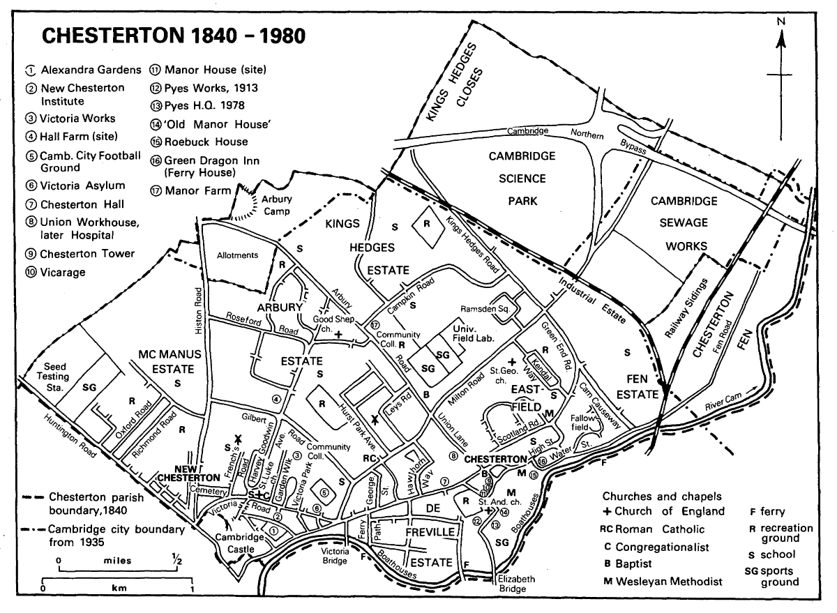
Chesterton 1840-1980
After 1801 the population of the village rose steadily from 741 to c. 1,110 in the 1820s. By 1841 the ordinary population had reached c. 1,345, and it continued to increase, largely through settlement in the new suburb, doubling to c. 2,480 by 1851. Growing thereafter by more than a third in each decade until the 1880s, it rose from 2,820 in 1861 to 3,865 in 1871, 5,420 in 1881, and 7,290 in 1891, then by a fifth or more to 9,365 in 1901 and 11,260 in 1911. In the 20th century the civil population reached 11,490 in 1921, and over 15,410 in 1931. That in private households within the wards comprising the ancient parish numbered 16,890 in 1951, 21,885 in 1961, 27,830 in 1971, and 28,900 in 1981. (fn. 38)
Chesterton village (fn. 39) stood by the river near the southern edge of the parish, its closes curving gently north-eastward along a high street men- tioned in 1293. (fn. 40) The church and main manor house stood to the south-west off Church Lane, so named by 1327, (fn. 41) called in the 1850s Church Street. A back lane to the north, mentioned in 1600, (fn. 42) renamed Scotland Road by 1881, was linked to the west end of the high street by Mill Lane, recorded by 1325, (fn. 43) renamed from the 1840s Union Lane after the Chesterton work- house built by it. Lesser lanes led south off the high street, including at the west end Chapel Street, so styled from the late 19th century, which bent back to Church Street. Ferry Lane ran south from the middle of the high street to the parallel Water Street, so named by 1580, (fn. 44) beside the river.
Few village houses dating from before 1800 survived 20th-century rebuilding and road widening. (fn. 45) The most substantial is Roebuck House, at the west end of Water Street, at which Robert Robinson in 1775 rebuilt, partly in brick, the rear of a symmetrical early 18th-century house, partly timber-framed, which has a five- bay front towards the river. Some timber-framed dwellings of the late 16th or the 17th century, with original brick chimney stacks, but recased in brick in the 18th century, survive further east along Water Street, but other timber-framed cottages standing in the 1950s had been demol- ished by the 1980s. The most notable house on the high street is the grey-brick early 19th- century Hill House, with a symmetrical front and an elaborate early 18th-century doorcase probably brought from elsewhere. Other older houses there are early 19th-century grey-brick cottages built singly or in terraces. Among those on the south was Thrift's Walk with a row of 10 in 1851. (fn. 46) A more substantial terrace survives at Pye Terrace east of Chapel Street, put up c. 1900. (fn. 47)
The village had 116 inhabited dwellings in 1794, (fn. 48) and grew to almost 150 in 1801, 216 in 1821, and 314 in 1841, besides 17 empty or being built. (fn. 49) In 1838, when there were 11 farmhouses and c. 15 public houses, the subdivision of 57 other houses produced 178 tenements alto- gether. (fn. 50) After 1841 the number of dwellings remained stable at c. 320, of which up to 20 might be unoccupied, into the 1860s, and in- creased only slightly to c. 375 in the 1870s and 1880s. The high street had 105-120 in the mid 19th century, c. 150 by 1861, and 185 by 1871, while Church Street then had 12-16, Union Lane 11-12, the northern back lane 50-60, and Water Street 35, increased by 1861 to 60. By the 1860s over 15 houses had been built along the Fen road which continued Water Street eastward. The population of the village and the four or five farmsteads built after inclosure to the north-east rose from c. 1,380 in 1841 to 1,425 in 1851, 1,450 in 1861, and reached 1,780 in 1871. (fn. 51) The village was still not linked physically to the expanding suburb in 1910, when it con- tained c. 395 houses, 160 on the high street, 45 on Church and Chapel Streets, and 50 cottages on Union Lane; it had, however, probably stretched outward at its edges, with 62 on Water Street and 29 on Scotland Road. (fn. 52)
The village lay off the main lines of communi- cation through the parish, which led toward the northern approach to Cambridge across the later Magdalene bridge over the Cam. Besides Hunt- ingdon way and the Howes mare, the latter mentioned c. 1300, (fn. 53) and probably leading to the hamlet of Howes by the far western corner of the parish, there was a road which, after briefly following the route to the village beside the river, forked north-east towards Milton. It was called Milton way by 1280, and was later distinguished as Mickle Milton way from a Little Milton way nearer to the fen. (fn. 54) North of the castle and medieval suburb another road leading directly north to Histon was called Histon way by 1300. (fn. 55) Ways through the fields, such as Oakington way, recorded by 1310, (fn. 56) were mostly stopped up at inclosure in 1838. To link the village with its neighbours to the north-west two roads were then partly straightened. One largely following the line of the earlier Mill way, the modern Arbury Road, runs north-west from Union Lane to enter Impington near Arbury Camp. Roughly parallel to the north-east was the new Kings Hedges Road. Those roads, with the 'New Hunt- ingdon Road' then laid out to link the Milton and Histon roads north of the castle, (fn. 57) and renamed Victoria Road by 1841, (fn. 58) formed the framework for Chesterton's suburban growth in the 19th and 20th centuries.
In the 1580s two houses, one originally built as a lodge, were put up on part of the waste near the castle, one on the site of a gravel pit, on land leased from the lord. (fn. 59) From the early 18th century a few cottages arose south of the road leading from Cambridge to the village, just within the parish boundary. (fn. 60)
The establishment of a new suburb was anti- cipated for some time before inclosure in 1838. From the 1810s small plots with common rights were sold, often to Cambridge tradesmen, with the prospect of acquiring potential building sites when Chesterton was inclosed. (fn. 61) By the 1830s William Custance, a Cambridge surveyor, had bought c. 60 a., favourably situated for building, and successfully pressed the inclosure com- missioners to put his allotment in the same area between the Huntingdon and Histon roads, where he proposed to build 'substantial houses for respectable tenants'. (fn. 62) Meanwhile Trinity and Magdalene Colleges, fearing the growth of 'a low suburb' with beerhouses and poor cottages, demanded at inclosure the creation of a tree- lined road with a walk by the river, and obtained a road 60 ft. wide as far as the junction of the Milton and Chesterton roads, upon which the building line was set back by 30 ft., the owners of brick pits there being expensively compens- ated for their removal. (fn. 63)
Building of the kind feared, creating a suburb called by the 1870s New Chesterton, began in the area south of Victoria Road, where 35 a. was split among several small landowners in 1838. (fn. 64) By 1851 many people had moved out from Cambridge, attracted by low rates and rents. (fn. 65) Over 240 houses had been built by then, occu- pied by c. 1,260 persons. The number of dwell- ings in that area rose to 350 by 1861, 525 by 1871, and more than 845 by 1881, when 78 more were being built. Another 110 were put up between 1881 and 1884. The population of the suburb rose from 1,470 in 1861 to 2,285 by 1871 and 3,760 in 1881, (fn. 66) when the number in term time was allegedly 4,015. It was then growing by almost 400 each year, and reached 4,725 in 1884, and nearly 5,000 by 1889 and 6,500 by 1892. (fn. 67)
The initial building was largely along the roads east and north from the Cambridge boundary. (fn. 68) From the late 1840s successive terraces of tall middle-class houses were put up along the north side of the Chesterton road, and by the 1870s stretched almost as far as the fork leading to Milton. St. George's Terrace had been built further east by 1861. The number of dwellings along that main road increased from c. 40 in the 1860s to 95 by 1871 and 114 in 1881, and to c. 240 by 1910. From the 1860s 20-30, and by 1881 55, stood east of the Milton road beyond the fork. The Huntingdon road saw little building before the late 1860s. Meanwhile more modest dwellings were put up further north: along the Histon road there were 60 by 1861, 110 by the 1870s, and 180 by 1910. Victoria Road had 55- 60 by the 1850s and 180 in 1881.
Except at Ferry Path, where a terrace of c. 30 cottages was built from 1844, (fn. 69) there was little building off the main roads until the 1870s. Some working-class cottages, 37 by 1851, were put up on Bermuda Row off the eastern side of the Histon road, others, over 30 by the 1860s, on Albert Street near the east end of Victoria Road. The area south of Victoria Road was gradually built up from the late 1870s, beginning with short streets of cottages at its north-western angle, while the parallel streets to the south-east, running north-west off the Chesterton road, such as Alpha Road, (fn. 70) were laid out and built with larger houses from the late 1880s. North of Victoria Road more roads, mostly dead ends, were gradually laid out running northward: by 1877 the private road to French's corn mill had 19 dwellings, while further east Primrose Street was begun by 1872. (fn. 71) The longer Garden Walk had 10 houses by 1881 and 30 by 1910, when 68 stood along Victoria Park, begun by 1895. (fn. 72) East of the Milton road junction more terraces rose along side streets from the late 1870s, including the 'New Cut', later George Street, laid out in 1875, (fn. 73) which had c. 25 houses by 1881. In the early 1880s (fn. 74) a network of small streets filled the angle between the Histon and Huntingdon roads; on land sold for building in 1904, (fn. 75) Richmond and Oxford Roads, planned in the 1890s, were built up with more substantial houses, number- ing respectively 110 and 130 by 1910. Further north-west, however, building on land once owned by Clare College was delayed until the 1930s.
Meanwhile to the east the construction of the Victoria Bridge, opened in 1895, (fn. 76) encouraged middle-class migration to new roads made on 31 a. sold in 1886, which extended almost to the village. (fn. 77) Between 1891 and 1893 the De Freville estate was laid out for large houses on De Freville Avenue and Montagu and Humberstone Roads, (fn. 78) quickly built up, (fn. 79) and having 220 houses by 1910. The empty land to their west was filled in between 1903 and 1910 with modest houses on streets bearing Boer War names. North of the main road Chesterton Hall Cres- cent, proposed in 1884 on the Wragg Gurney estate, (fn. 80) was partly built up between the 1890s and 1910.
Further north the survival of the large Hall and Manor farms (fn. 81) restrained new building, which in the 1920s consisted mainly of ribbon development along the Milton road, by 1930 reaching almost to the railway line. (fn. 82) In 1909 the county council sold for building 58 a. in the angle of the Milton and Arbury roads, (fn. 83) which were not immediately built upon. North of the Milton road the Highworth estate was laid out for sale in 1914; Highworth Avenue and Leys Road had been built up by 1927. Another 25 a. to their north-west then sold for building was also built up by the mid 1930s as part of the Hurst Park estate, (fn. 84) replacing a large Victorian house of that name. To the south-west St. John's College laid out c. 1931 on the recently acquired Wragg Gurney estate over 100 plots each side of Gilbert Road, linking the Milton and Histon roads, for middle-class houses built by the late 1930s. (fn. 85) On the northern part of that estate, where Roseford Road was begun in 1936, the outbreak of war stopped building.
From the 1930s the emphasis changed from private to public building. (fn. 86) The city council had already put up some houses along arboreally named roads between the Chesterton and Milton roads, acquired in 1921. (fn. 87) About 1930 there followed more council estates around Kendal Way and Ramsden Square each side of the Milton road beyond the point which ribbon building had then reached. By 1931 there were c. 630 houses in the area soon to be St. George's parish, including 142 along the Milton road, 115 on Ramsden Square, and 158 off Green End Road. The council shortly built 220 more on Kendal Way and Trinity Hall 140 others on land to the west. (fn. 88) Housing associations were also active: the Cambridge association was then building in the angle between Union Lane and the Milton road. The Hundred Houses associ- ation built Eastfield further east along Scotland Road, adding c. 1955-6 the Scotland Road estate of 215 dwellings to the west. Fallowfield east of the old village was also developed as assisted housing by the late 1930s.
Even more extensive council building followed the Second World War. (fn. 89) In 1947 the city council acquired the unused northern part of the former Hall farm from St. John's College, (fn. 90) and in the 1960s most of the former Manor farm from the county council. (fn. 91) The only large private development in that area was the McManus estate west of the Histon road, where c. 575 dwellings were put up from Windsor Road northwards in the early 1960s on land sold by St. John's College in 1959. (fn. 92) East of the privately built Fen estate, begun before 1939, the city council inserted c. 300 dwellings between the Cam Causeway and the railway. From 1957 it developed North and South Arbury on c. 100 a. between Gilbert Road and Arbury Road, around a network of side roads, eventually comprising c. 2,400 dwellings. Between 1957 and 1960 it also started work in the area north and west of Ramsden Square, where 800 houses were built on c. 85 a. In 1967 building began on the Kings Hedges estate north-west of Campkin Road, where by 1986 some 1,570 dwellings had been completed on 125 a., many in blocks of three and four storeys surrounded by grass. By the mid 1980s building had almost reached the city boundary. The new council estates were inhabited largely by families removed from older parts of the city, and there were many complaints of lack of social facilities, of loneliness among the old, and of vandalism by the young. (fn. 93)
Chesterton's road communications followed the lines established before 1800. The Milton road was part of the Cambridge-Ely turnpike from 1763 to 1874, (fn. 94) the tollgate closest to the town being moved outward in 1838 to the Jolly Waterman. (fn. 95) No bids were received for tolls in 1846, following the opening of the railway. (fn. 96) In the late 20th century part of the Cambridge northern bypass, constructed from 1976 and opened in 1979, swept through the northern part of Chesterton by then transferred to Milton. (fn. 97) Along the eastern edge of the parish the Great Eastern Railway built in 1844 and opened in 1845 its main line between Cambridge and Ely, still fully in operation in 1987, and added in 1847 another line running north-west towards St. Ives and Huntingdon, (fn. 98) which after 1970 was open only for occasional goods traffic. (fn. 99) The angle between the two lines was still occupied by sidings in the 1980s. By the 1850s specially built cottages off the Fen road housed railway staff. The Railway Tavern stood nearby. (fn. 100) The neighbouring ballast pits, much used for skating in winter in the mid 19th century, (fn. 101) were later filled in to provide a site for Chesterton Junction railway depot, where welded rails were made until the late 20th century. (fn. 102)
Waterborne communications were also im- portant to the village, which was linked to Cambridge by several ferries from the Middle Ages. In the late 14th century control of the ferries was contested between Barnwell priory, lord of the manor, and the borough. About 1390 the burgesses forcibly obstructed the priory's nominee as ferryman, seized his takings, and appointed its own lessee, as it continued to do until the 1490s. (fn. 103) In 1506, however, it ceded to the priory all its claims to the 'old ferry', (fn. 104) which remained with the manor until the 1580s. (fn. 105) In the 1550s and 1560s the greater part of the profits, perhaps £12 out of an annual rental of £14, was said to arise during Stourbridge Fair. (fn. 106) By the mid 18th century the ferry was attached to the Green Dragon inn, often called the Ferry House. (fn. 107) By the 19th century that ferry, leading to Stourbridge common, was the easternmost of three in regular use, including one sold in 1790. (fn. 108) The others were Cutter Ferry, to Midsummer common, attached until 1920 to the Wragg Gurney estate, (fn. 109) and one established by the early 18th century from Ferry Path to the Fort St. George inn. (fn. 110) Although the Conservators of the Cam provided footbridges across the lock nearby from the 1790s, (fn. 111) that ferry remained in regular use in the 1840s, (fn. 113) and those further east into the 1930s. They were superseded only by the building of substantial road bridges: the Victoria Bridge of 1895, south of the fork of the Chester- ton and Milton roads, and the Elizabeth Bridge, opened in 1971, (fn. 113) south-west of the village, which its approach road severed from the sub- urb.
Boat building, probably undertaken in the Middle Ages, when one family was surnamed Shipwright from c. 1280 to c. 1335, (fn. 114) flourished in the 19th century. The Crosses, who started a boatyard near the Fort St. George crossing in 1799, were in business until the 1860s, and the Searles had opened another nearby, facing Midsummer Common, by the 1840s. (fn. 115) In the mid 19th century many people were employed in the village in that trade along Water Street, one boatbuilder employing 5 men in 1861, another 8 in 1881. (fn. 116) From the 1860s to the 1890s there were usually four or five firms of boatbuilders, which provided boats largely for pleasure and racing. Private boatyards gradually disappeared as rowing clubs established their own boat- houses: the university and three colleges had boathouses in the 1880s, three more colleges by 1896. (fn. 117) In 1910 there were 13 college boathouses. Of five private ones, (fn. 118) two closed c. 1935, a third c. 1950; (fn. 119) the last survivor, Banhams marina, was removed c. 1970. (fn. 120) In the 1980s college boathouses still lined the bank between the Victoria and Elizabeth bridges.
Chesterton had long provided other diversions for visitors from Cambridge. In 1579 students going to the village to play football were am- bushed and beaten by the villagers, incited by the constable Thomas Parish. (fn. 121) The university, relying upon a Privy Council order of 1575, sought to suppress such pastimes so close to Cambridge, including bear-baiting in 1581, (fn. 122) bull-baitings, and stage plays, as in 1592, when during Stourbridge Fair a group of the queen's players lodged and apparently performed in houses at Chesterton. (fn. 123) Implicitly supported by the lord lieutenant and county justices, despite the disapproval of the Privy Council, the par- ishioners, led by John Batisford, still in the early 17th century opposed the university's attempts to regulate the village alehouses. Only in 1616 did the university obtain confirmation of its power to control and license alehouses in Chester- ton, (fn. 124) which was not relinquished until 1856. (fn. 125) In the late 18th and early 19th century the village had tea gardens, bowling greens, skittle grounds, and billiard rooms. (fn. 126)
The proximity of the town also affected the number of public houses in the parish. In the late 17th century (fn. 127) only 2-4 alehouses were regularly licensed, in the early 18th century 6, in the 1750s and 1760s c. 10, and from the 1770s only 6 again. Several were acquired by Cambridge brewers in the 18th century, (fn. 128) in- cluding two near the castle, converted from cottages after the 1740s, also the Three Horse- shoes, renamed by 1765 the Castle, still standing close to the castle in the 1980s. (fn. 129) Of those in the village itself in the 1750s, the Green Dragon, established in the 1730s, (fn. 130) in part of a range of four 16th-century timber-framed dwellings on Water Street, with dormers toward the street over a projecting first floor, (fn. 131) was still open in the 1980s; the Three Tuns remained open into the 1870s, while the Bleeding Heart was con- verted in the 1920s into a Co-operative store, demolished c. 1972. (fn. 132) The Queen's Arms of 1780, perhaps the King's Arms of 1755, and successively renamed the Bowling Green, after its main attraction, in the 1790s and the Sir Robert Peel c. 1840, reverted to its first name in the 1890s. Closed in 1936 and later converted to offices, the house still retained in 1985 its upstairs billiard room. (fn. 133) Three more public houses were opened in the 1830s, eight in the early 1840s, and ten more between 1850 and 1855, only three of which, the Pike and Eel, the Haymakers, and the Yorkshire Grey, rebuilt c. 1935, were still open in 1987. (fn. 134) By 1855 there were 26 public houses in the whole parish, mostly in the village. In the new suburb was the Portland Arms, opened on the Milton road in 1839, converted in the 1880s into Searle's Hotel and rebuilt in the 1930s, when its old name was revived. (fn. 135) Some of the village taverns were of poor repute in the 1840s, attracting questionable people with music and dancing, and giving rise to fights between village lads and men from Cambridge. (fn. 136) About 1871 there were still 12 public houses on the village high street and 4 elsewhere in the village. (fn. 137) A Conservative Working Men's Associ- ation, founded in 1870, initially drew c. 200 members roused by the threat posed by the Liberals' proposed licensing laws to Chesterton's numerous drinking places, but it faded after 1872. (fn. 138) The village still contained 13 public houses in 1910, (fn. 139) but only 6 in the 1930s and 1960s, (fn. 140) 2 of which fell victim to road widening c. 1975. (fn. 141) Among those in the suburb was the Golden Hind by the Milton road, opened in 1937, (fn. 142) in an opulent Elizabethan style.
Under the Inclosure Act, (fn. 143) 91/2 a. in the east field were allotted in trust as a recreation ground. (fn. 144) In the late 19th century that land was being leased and the rent used for public purposes. (fn. 145) Control was transferred in 1891 to the new local board, (fn. 146) whose successor, the urban district council, still owned 4 a. by Fen Road in 1910. (fn. 147) A new recreation ground, c. 5 a. west of the church acquired by 1888, (fn. 148) was still in use in the 1980s. Cricket matches run by a village club were recorded in the 1830s. (fn. 149) A cricket club mentioned in 1853 was promoting matches on the Church Closes by the 1870s, (fn. 150) while another was pro- posed to involve New Chesterton residents too in 1881. (fn. 151) A village music society was giving concerts at the National school by 1880. (fn. 152)
Chesterton's friendly societies included branches of the Ancient Shepherds, probably formed c. 1845, which had 40 members in 1890, and the Ancient Order of Foresters, with some 70 members by 1870, regularly meeting at the Bleeding Heart. Both were still active in the 1890s. (fn. 153) In 1876 the vicar started a working men's club with 90 members, and provided a reading room and coffee house. By 1884 financial difficulties and a declining membership led to the transfer of its premises to the Church Tem- perance Society. (fn. 154) The enlarged coffee tavern was reopened as a reading and recreation room with 50-70 members in 1888. (fn. 155) In 1931 Mrs. R. Clark of the Old Manor House, in memory of her son killed in the First World War, gave the former Wesleyan chapel on the high street for use by the Chesterton Men's Club, which had 200 members within a year and was still active in the 1980s. (fn. 156) The East Chesterton Community Association, formed in 1973, was replaced in 1981 by one linked to the new St. Andrew's school. (fn. 157) From the late 19th century the new suburb was served by various social organiz- ations. An Old Chesterton cottagers' garden club was replaced in 1873 by a new one, which usually held its annual flower and vegetable shows at the Industrial school or St. Luke's schoolroom on Victoria Road. (fn. 158) The New Chesterton Young Men's Union, started in 1885 to provide debates, lectures, and a reading room, (fn. 159) was restyled from 1892 the New Chesterton Institute. The premises in Holland Road south of Victoria Road, into which it had recently moved in 1892, (fn. 160) were enlarged in 1927, and were still in regular use in the 1980s. (fn. 161) Between 1900 and 1910 the urban district council converted the site of the last brickyard in New Chesterton into Alexandra Gardens. (fn. 162) The Arbury estate community centre was opened in 1974. (fn. 163)
The Chesterton poor-law union, formed in 1836, (fn. 164) immediately acquired a site for a work- house south-west of Mill Lane. A building designed by John Smith of Cambridge was started the same year, (fn. 165) and completed in 1838, for up to 350 paupers. Of grey brick in three storeys, it has four wings extending from a central octagon, containing the master's lodging and a brick-vaulted kitchen. (fn. 166) In the mid 19th century it usually housed c. 160 inmates. (fn. 168) In 1930 the buildings were converted into a hos- pital, for old people by the 1960s, when there were 200 beds. It was still in use in 1987. From 1964 the East Anglian Regional Hospital Board occupied a large office block built to the south- west. (fn. 168)
After inclosure land in Chesterton was increas- ingly used for public and academic activities primarily serving the inhabitants of Cambridge. In 1843 the Cambridge Cemetery Co. opened a non-denominational cemetery on c. 10 a. east of the Histon road, whose management was transferred to the city council in 1936. The central chapel, built on a Greek cross plan in Gothic style, was demolished after 1955, but the small Tudor-style lodge survived in 1987. (fn. 169) In 1841 the Cambridge Friendly Society built the Victoria Asylum north of Victoria Road to pro- vide 12 homes for respectable elderly members. Other one-storey dwellings, some themselves later removed, were added from the 1890s on- wards; the original block, designed by George Bradwell with a pedimented centre upon Doric pilasters, (fn. 170) was demolished in the 1970s. (fn. 171) Be- tween 1896 and 1920 the Church-sponsored Waifs and Strays Society used the former Indus- trial school buildings off Victoria Road for the Harvey Goodwin Home for boys. Reopened in 1924 after rebuilding, it was finally closed in 1980. (fn. 172) About 1893 the Cambridge borough council bought all the 65 a. owned by the parish charity east of the Milton road, upon which a sewage farm was laid out in 1895. It was enlarged to cover 177 a. in 1923, and the farm was converted in 1937 into a sewage treatment works, extended between 1973 and 1978. (fn. 173) In 1922 a football stadium for Cambridge City football club was built off the east end of Victoria Road. It was partly reconstructed, partly redeveloped in 1987. (fn. 174)
Some Cambridge colleges established sports grounds in Chesterton: Trinity had a cricket ground by 1885. (fn. 175) Other grounds off the Milton and Huntingdon roads laid out after 1900 were still in use in the late 20th century. (fn. 176) In 1921 the National Institute of Agricultural Botany established its first seed testing station in the far west corner of the ancient parish beside the Huntingdon road. The site was its national headquarters in 1987. (fn. 177) In 1909 three professors bought 10 a. north of the Milton road as a site for field laboratories where the university's biological departments could keep livestock for scientific observation; part was used for build- ings for the Institute for Animal Nutrition. That land and another 17 a. acquired in 1913 were made over to the university in 1913 and 1920. Some buildings were occupied by the depart- ment of Animal Pathology, later of Veterinary Studies, from 1927 to 1949, after which they were used by the departments of Genetics and Physiology until 1975. From 1929 other new buildings, extended in 1950 and 1968, were occupied by the Dunn Nutritional Laboratory, founded in 1927 and concerned until the 1960s mainly with studying the place of vitamins in human diet. It was still there in 1987, when the rest of the land, along with the adjoining University athletics ground and Magdalene Col- lege sports field to the south, was sold for development. (fn. 178)