A History of the County of Cambridge and the Isle of Ely: Volume 9, Chesterton, Northstowe, and Papworth Hundreds. Originally published by Victoria County History, London, 1989.
This free content was digitised by double rekeying. All rights reserved.
'Landbeach: Introduction', in A History of the County of Cambridge and the Isle of Ely: Volume 9, Chesterton, Northstowe, and Papworth Hundreds, (London, 1989) pp. 138-141. British History Online https://www.british-history.ac.uk/vch/cambs/vol9/pp138-141 [accessed 24 April 2024]
LANDBEACH
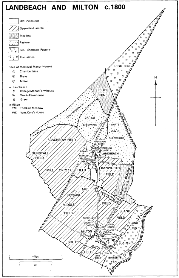
THE parish of Landbeach, (fn. 1) c. 6 km. (4 miles) north of Cambridge and covering 900 ha. (2,225 a.), is approximately triangular. (fn. 2) The eastern boundary partly follows the Roman Car Dyke running north-west before bending northeastward to run along the Roman road latterly called Akeman Street, which led from Cambridge to Ely. The straighter north-western boundary from 1235 followed the Beach ditch then dug. (fn. 3) The zigzagging south-western boundary was presumably determined by old furlong divisions. In 1985 an area of 30 ha. (74 a.), including a line of 14 houses built west of the Milton road, was transferred from Milton to Landbeach. (fn. 4)
The parish lies upon gault overlaid in the eastern half with river gravels. Until the 18th century much land in its narrow northern angle was marsh and fen. The principal drainage channels (fn. 5) lay along the boundaries. From the Middle Ages the Car Dyke, called locally the Tilling or Tillage, (fn. 6) drained north-eastward into the Beach Lode, which by 1359 divided the marshes of Landbeach from those of Waterbeach, at its start running along the Roman road. (fn. 7) Into the Car Dyke ran lesser watercourses flowing east of the village. The Beach Ditch was probably made after an agreement in 1235 to sever Landbeach's common marshes from those of Cottenham to the west. (fn. 8) In the land further east the manorial court had almost annually to enforce the scouring of watercourses and other drainage ditches. Even in the south the land was probably severely affected by a rise in the water table in the early 14th century, the north-east corner of the village being protected with massive embankments around the site of Chamberlains manor. (fn. 9) From the Middle Ages to inclosure in 1808 the southern half of Landbeach was devoted to arable farming under a triennial rotation, the northern part being used primarily as pasture. (fn. 10)
The settlement at Landbeach, called in 1086 'Utbech', (fn. 11) and between 1225 and 1325 occasionally 'Inbech', (fn. 12) was perhaps originally dependent upon its eastern neighbour Waterbeach, and may have arisen when dwellings used in summer by shepherds from Waterbeach on the slightly higher ground in the south-west of Landbeach were occupied throughout the year. (fn. 13) By 1086 Landbeach was inhabited by 32 peasants. (fn. 14) Its population had by 1279 included c. 55 landholders, (fn. 15) although in 1327 there were only 29 taxpayers. (fn. 16) The Black Death struck the village severely in May and June 1349, (fn. 17) probably carrying off half the inhabitants. The number of males in tithing paying 'head pennies', which in the 1330s and 1340s ranged between 65 and 70, (fn. 18) fell to 34 in October 1349, (fn. 19) and was usually only 27 by the 1390s. (fn. 20) In 1377 the poll tax was paid by 114 villagers. (fn. 21) The population continued to shrink later: the number of villagers owning livestock which strayed, c. 25 in the mid 15th century, (fn. 22) fell below 20 after 1500. (fn. 23) There were only 26 taxpayers in 1524, (fn. 24) and 36 households in 1563, (fn. 25) although the villagers alleged in 1549 that there were then altogether c. 170 inhabitants. (fn. 26)
Under Charles II 68 dwellings were returned for the hearth tax in 1664, only 52-54 later, (fn. 27) and in 1676 there were said to be 127 adults. (fn. 28) The number of households probably remained almost stable during the 18th century: there were 51 families in 1728, and 55 houses in 1795, including 239 people. (fn. 29) After 1800 the population grew rapidly until 1821, to 371, then more steadily, to reach 468 in 1841. (fn. 30) Despite emigration, sometimes assisted by the parish, (fn. 31) numbers attained a peak of 526 in 1851, and after a setback in the 1860s had climbed again to 510 by 1881, thereafter declining slowly to 389 in 1911. A slow growth then resumed, raising the population to 473 by 1931, to c. 630 in the 1950s, and, after a pause in the 1960s, to 742 by 1981. (fn. 32)
The early medieval village (fn. 33) probably occupied an almost rectangular site east of the Roman road, and just above the 5-metre contour. Internally it was divided by several lanes running east-west and north-south. The north-eastern quarter was occupied by the farmstead of Chamberlains manor with the church and rectory house to the south by forking lanes. The lane on the east led south to a small green at the junction of an east-west lane, surviving as Cockfen Lane, where a market cross is said to have stood. Extensive closes around the site of Brays manor stretched across the south end of the rectangle. Probably in the 12th or 13th century more dwellings were built further south each side of the road toward Milton, which became the modern High Street. Those to the west were almost certainly put up on former open-field land, their tofts still being reckoned as selions in the 15th century. (fn. 34)
From the late 14th century the number of inhabited dwellings gradually diminished, and customary tenants were regularly but vainly ordered to put their houses in repair. On Chamberlains manor between four and six were repeatedly reported as badly maintained in the late 1350s, (fn. 35) and, after a temporary recovery, again between 1400 and the 1430s, when 4 or 5 more were ruinous on Brays manor. (fn. 36) In the mid 15th century the lord of Chamberlains converted one unwanted close by the street west of his manor into a green which survived until inclosure. (fn. 37) By 1500 the village was divided into Green End around that green and Cambridge End, by 1639 Land End, to the south. (fn. 38) On Brays manor the Kirkbys, its lords after 1500, left almost all their copyhold messuages untenanted. In 1549, when the village was supposed to have contained 37 tenements, the villagers asserted that Richard Kirkby, desiring to expand his pasturage, had let 14 fall into decay, leaving only the manor house and two other houses on his manor. (fn. 39)
After 1550 new cottages were sometimes built on the waste. (fn. 40) By 1639 such cottages numbered 18 out of the 63 dwellings then recorded. (fn. 41) Under Charles II only 10 of 52-54 houses had more than two hearths, and 16 had only one. (fn. 42) The Plague House, a timber-framed, thatched, partly medieval cottage on the high street, restored in the 1970s, traditionally commemorates the shelter given in 1666 by the rector William Rawley to refugees from the plague at London. Rawley's wife and son both died that summer. (fn. 43) Surviving late 17th-century cottages (fn. 44) include a range of four two-storeyed, timber-framed and thatched ones south of the rectory, with overhanging gables to the street, repaired after 1960. Among more substantial 17th-century houses is the red-brick Old Beach Farm with gabled wings projecting to the east, perhaps the first brick house built in Landbeach. (fn. 45) Other timber-framed houses such as the Limes and the former Black Bull inn were refaced in brick in the 18th and early 19th century. After 1800, following the decay of the ancient cross-lanes, most dwellings stood along the north-south street. In the 19th century, when there was some infilling, besides rebuilding, in grey brick, the number of inhabited houses steadily increased from c. 50 in the 1830s to c. 115 in the 1860s, (fn. 46) almost all of which in 1861 stood on the high street. Only two farmhouses, for Rectory and Oldfield farms, had been built out in the former open fields since inclosure in 1808. (fn. 47) The number of houses shrank slightly from 1871, when seven stood empty, to c. 100 by 1901. (fn. 48) In 1910 there were 91 dwellings, all but 19 styled cottages. (fn. 49) Numbers grew again from the 1920s to reach c. 140 by 1931, 196 by 1951, 228 in 1961, and 278 in 1981. (fn. 50) Besides some infilling within the old village closes, there was much ribbon building in the 1930s and later along the Waterbeach road and each side of the main Cambridge-Ely road, which runs just inside the parish's eastern boundary. (fn. 51) In the 1850s 8-10 houses had already been scattered along it.
Landbeach and Milton c. 1800
Those roads were both created in modern times. The original route to Ely had probably led through the village and northward to converge with the line of the Roman road at Goose House or Hall. About 1286 the lord of Landbeach and others were accused of obstructing a road used by cattle drovers, which led from Waterbeach to Cambridge past 'Rudich', Waterbeach's southern field. (fn. 52) By 1550 travellers were allowed to use a track across Landbeach's meadows to the east, (fn. 53) and that route was selected, despite opposition by the villagers to encroachment on their common grassland and an increase in their statute labour, when the turnpike road from Cambridge to Ely was laid out under an Act of 1763. (fn. 54) It remained a turnpike until 1874. (fn. 55) The straight roads east to Waterbeach and north-west to Cottenham were set out at inclosure, while that leading south along the line of the Roman road towards Impington was left without improvement to follow its old course. (fn. 56)
The village usually had in modern times five to seven public houses, (fn. 57) including the Black Bull, established by 1765, (fn. 58) at which a book club met, 1846-71. (fn. 59) Three others recorded by the 1850s had closed by 1960. (fn. 60) In 1986 there remained only the Slap-Up, opened by 1864, (fn. 61) just within Landbeach parish, where a side road to Waterbeach leaves the turnpike. (fn. 62)
The village Feast, still observed in the 1860s, had in 1779 been moved with that of Waterbeach to May. (fn. 63) Football was traditionally played on Camping close until c. 1800. (fn. 64) About 1886 a reading room for working men had 40 members. (fn. 65) A village hall, opened in 1936, was enlarged in 1975, when Landbeach had several social and sports clubs. An adjacent field was bought c. 1972 as a recreation ground. (fn. 66) In the 1970s the Landbeach Society, formed in 1971 under the inspiration of the village's historian, Dr. J. R. Ravensdale, to preserve its buildings and character, promoted open days when the public could visit the older houses. (fn. 67)
Extensive gravel diggings in the north end were partly flooded by the late 1960s, when their owner, Leonard Dickerson, planned to use 80 a. of them for water sports. (fn. 68) In 1979 he opened the Landbeach Marina on 120 a. there, including a park for 400 caravans; its lake provided facilities for boating, water-skiing, and fishing. (fn. 69)