A History of the County of Cambridge and the Isle of Ely: Volume 9, Chesterton, Northstowe, and Papworth Hundreds. Originally published by Victoria County History, London, 1989.
This free content was digitised by double rekeying. All rights reserved.
'Over: Introduction', in A History of the County of Cambridge and the Isle of Ely: Volume 9, Chesterton, Northstowe, and Papworth Hundreds, ed. A P M Wright, C P Lewis (London, 1989), British History Online https://www.british-history.ac.uk/vch/cambs/vol9/pp339-343 [accessed 3 May 2025].
'Over: Introduction', in A History of the County of Cambridge and the Isle of Ely: Volume 9, Chesterton, Northstowe, and Papworth Hundreds. Edited by A P M Wright, C P Lewis (London, 1989), British History Online, accessed May 3, 2025, https://www.british-history.ac.uk/vch/cambs/vol9/pp339-343.
"Over: Introduction". A History of the County of Cambridge and the Isle of Ely: Volume 9, Chesterton, Northstowe, and Papworth Hundreds. Ed. A P M Wright, C P Lewis (London, 1989), British History Online. Web. 3 May 2025. https://www.british-history.ac.uk/vch/cambs/vol9/pp339-343.
OVER
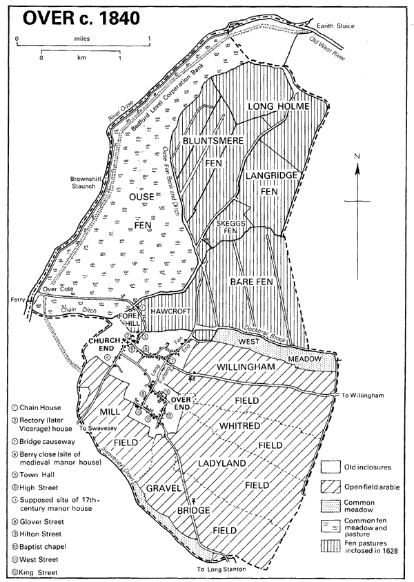
OVER lies 14 km. (c. 9 miles) NNW. of Cambridge on the edge of the fens and the former Huntingdonshire boundary, covering 1,512 ha. (3,737 a.). (fn. 1) The large village formerly had a variety of occupations and a strong nonconformist tradition. The flat northern half of the elongated parish is below 5 m. (16 ft.) and mostly comprises fertile loamy soils underlain by river gravels in Bare fen and clays and silts elsewhere. Peat beds cover the north-east corner by the former Willingham mere. (fn. 2) The name of Bluntsmere fen may have been derived from another mere (fn. 3) which left no geological or documentary record. The higher southern part of the parish lies mainly on clay and glacial gravel, rising gently to over 25 m. (82 ft.) on the gravel and falling away in the south-west to the Swavesey boundary.
The western boundary follows the river Ouse and ditches draining into it. One ditch was called the lode in 1575, later Chain ditch. On the eastern side only the northern part of the Willingham boundary was defined by 1575, more than 1,000 a. of fens being intercommoned by the two parishes until partition c. 1618. The south-east boundary partly follows tracks called c. 1600 the mere way and the baulk or procession way. (fn. 4)
The fen commons east of Ouse fen bank were inclosed in 1628. (fn. 5) Part of the area inclosed was Bare fen, divided into over 100 rectangular fields each covering c. 3 a. Most of the hedges inclosing them were grubbed up between 1955 and 1983. The open fields and the remaining fen common, Ouse fen, were inclosed under an Act of 1837 which had been delayed by sustained opposition from poor commoners and radical M.P.s. (fn. 6) The parish has always been predominantly agricultural, though in the 20th century market gardening became important and many orchards were planted, mainly south of the village. No woodland was recorded in 1086. (fn. 7) About 1650 coal was being brought by water from King's Lynn (Norf.). (fn. 8)
In 1575 the north part of the parish comprised meres and fens which were mostly flooded in winter. (fn. 9) One cause was the fluctuating extent of the mere, until the early 17th century indifferently named Over mere and Willingham mere. After the parish boundary was fixed the area permanently under water was in Willingham. Its draining is treated elsewhere. (fn. 10) Many of Over's drainage ditches fell towards the mere. In 1622 up to 120 a. in Over once part of the mere were said to have become dry land (fn. 11) but attempts to drain the mere usually harmed the fens in Over: Sir Miles Sandys's blockage of one of its outlets c. 1622 was claimed to cause flooding which had not been prevented by a new channel ordered to be made c. 1636. (fn. 12)
Over c. 1840
By 1605 the parish owned a windmill which lifted water into a ditch leading to the mere. (fn. 13) Shortly before 1696 a second windmill or a replacement was built in Langridge fen. (fn. 14) In the early 18th century, after the mere had been drained, ditches along the parish boundary fed Over's watercourses into Willingham lode and so to the Old West river. The lord and fen reeves of Willingham blocked a ditch on the boundary shortly before 1730, hindering that line of drainage. (fn. 15) In 1740 Over and Willingham agreed to build a new drainage windmill just inside Willingham, (fn. 16) redirecting the drainage of Over's fens into the Ouse above Earith sluice. Over's open fields were to drain into a new ditch, the later Dockerel brook, which fell into Willingham lode. (fn. 17) The Over Inclosure Act of 1837 provided for further improvements to the drainage of land north of Bare fen. (fn. 18) The drainage board established under the Act installed a steam engine c. 1840 (fn. 19) at the head of Crane's fen ditch to pump water into the Ouse. It was replaced c. 1941 by a diesel engine, which remained in use as a stand-by after electric pumps were installed c. 1960. The drainage board was amalgamated with that of Willingham West fen in 1974. (fn. 20)
The river Ouse was a recurrent cause of inundation until the mid 20th century. By 1600 the area liable to flood was restricted by two banks. One lay c. 100 m. from the river and was often worn away by its action; the other was Ouse fen bank which follows a sinuous course 300-1,200 m. east of the river and is c. 1.5 m. high and 15 m. wide in places. They had the effect of leaving Ouse fen flooded longer than the fens on the east. (fn. 21) Normally the silt left by floodwater produced good crops of hay but in 1575 it was said that in some years Ouse fen was so wet that it could not be mown at all. (fn. 22) About 1650 the bank alongside the river was raised in height by the Bedford Level Corporation. (fn. 23) When it failed in 1947 serious flooding resulted in Over, Willingham, Cottenham, and Haddenham fens. (fn. 24) The 171 a. in Ouse fen allotted to the Corporation c. 1650 were apparently bought by the parish. (fn. 25)
Over lode was perhaps made as a navigation channel between the Ouse at Over Cote and the village. Its modern name of Chain ditch probably derived from a chain preventing unauthorized use of the bridge crossing it at Chain House, the only way into Ouse fen from the village: in 1575 one duty of the hayward, who perhaps lived at Chain House, was to open and shut the chain of the bridge. (fn. 26) In the early 17th century a weir across the Ouse at Over Cote intentionally restricted the river so that in time of floods water was forced up Chain ditch and into the fens to irrigate them. (fn. 27) By then the ditch was probably no longer navigable. The Bedford Level Corporation's bank blocked it c. 1650 but the parish had a tunnel made under the bank to keep the ditch in use. (fn. 28)
Navigation on the Ouse was improved by the building of Brownshill staunch c. 1830. (fn. 29) In 1840 a public landing place was made at the end of Over Cote Road. (fn. 30) It remained in use for cargoes of coal and corn until c. 1900. (fn. 31)
A ferry across the Ouse at Over Cote was recorded in 1575 (fn. 32) and remained in use in the early 20th century. (fn. 33) Roads lead from the village to Willingham, Swavesey, and Long Stanton along the lines of the pre-inclosure roads. (fn. 34) About 1600 travellers between Earith bridge and Cambridge used the flood bank near the Ouse. (fn. 35) The main fen droveway in the Middle Ages was probably that on Ouse fen bank. Straight droveways were laid out after the inclosures of 1628 and 1840. The railway line between Cambridge and St. Ives, opened in 1847, crosses the southern part of the parish. (fn. 36) In the early 20th century a carrier ran between Over and Swavesey station. (fn. 37)
Over's population increased greatly between 1086, when 35 peasant occupiers were recorded, (fn. 38) and 1279, when there were c. 140 tenants. (fn. 39) The lay subsidy in 1327 was paid by 91 persons and the poll tax in 1377 by 378 adults. (fn. 40) The village was already large in the 1520s and grew by the 1560s to be the most populous in Cambridgeshire outside the Isle, with 123 households. (fn. 41) Numbers in 1728 were estimated at 640 in 153 families, (fn. 42) but increased only slowly in the remainder of the 18th century, reaching 689 in 1801. (fn. 43) After 1811 the population rose again to exceed 1,200 by 1851, then fell steadily, except in the 1860s, to c. 900 by 1901 and fluctuated at about that level until 1961. In the 1960s and 1970s large numbers of newcomers more than doubled the population to nearly 2,000 in 1981. (fn. 44)
The present straggling village contains two separate nuclei of settlement which have grown together. The church occupies a gravel knoll at the north-west corner of the village overlooking the fens. Its site at the end of a low ridge probably gave rise to the name Over. (fn. 45) High Street curves gently south-east from the church, lined on part of each side by elongated tofts. (fn. 46) Stretches of back lanes survive on both sides. There were also medieval houses, including the manor house, on the street leading south-west from the church towards Swavesey, from c. 1850 called Station Road. Another group of older houses clusters north-east of the church by Bridge causeway, part of the road to Over Cote. The name Church End, now applied only to the road in front of the churchyard, formerly referred to the whole settlement centred on the church. (fn. 47) About 500 m. east of the church High Street is crossed at right angles by a road called Long Furlong to the south and Fen End to the north. Long Furlong was not built up until the 20th century but Fen End was probably laid out in the Middle Ages and is lined by long tofts on its south-east side and in part by shorter ones opposite.
Over End, named not from the parish but to distinguish it from Nether or Church End, (fn. 48) lies almost 2 km. SSE. of the church. The arrangement of plot boundaries suggests that it may have originally formed a square green lined by houses on the north-east and south-west sides, (fn. 49) now Hilton Street and West Street. Those streets are linked at the east end by King Street, in the centre by Unwin's Lane, and at the west end by Glover Street, which projects north to run into Long Furlong.
In 1575 the village had 112 houses and 29 cottages. (fn. 50) They presumably lined High Street, the Swavesey road, and Fen End and evidently surrounded and partly covered the probable former green at Over End. A house next to the green was mentioned in 1587 (fn. 51) and six cottages were reported in 1616 as having been lately built on the lord's waste. (fn. 52) By 1674 the hearth tax was paid by 155 houses. (fn. 53) Surviving 17th-century houses show the use both of timber and of locally made red brick. One in Fen End has a curvilinear gable. (fn. 54) Sycamore Farm in Over End has a sophisticated design of the 1720s using red and red-brown brick; it is of seven bays and two storeys with a tiled hipped roof. There are other 17th- and 18th-century houses throughout the village, particularly in High Street.
The village evidently shrank in the 18th century to only 115 houses in 1811. (fn. 55) Many plots remained empty in the mid 20th century, especially in Church End. By the early 19th century many houses were subdivided, the 119 recorded in 1821 being occupied by 176 families. Overcrowding was still common in the 1860s. (fn. 56) New building in the mid 19th century filled some gaps in the village and there were nearly 250 houses in 1901. A few were built in the 1890s at the north end of Long Furlong, but Church End and Over End were not continuously built up until the mid 20th century. Nearly 100 houses were added between 1921 and 1961 and growth was very rapid from the late 1960s. More than 100 houses were built in that decade, mainly by infilling after 1967, (fn. 57) and many more in the 1970s. The 750 dwellings in 1981 included few council houses: only a dozen in New Road south of High Street and c. 40 east of Station Road. Nearly all the new houses in and after the 1960s were private, the largest estate being one of over 100 in former paddocks between Over End and Church End, built after 1978. (fn. 58) Another 70 or more were put up in two groups north of Over End, while others extended the built-up area along the roads to Swavesey, Long Stanton, and Willingham.
The only dwellings outside the village before inclosure in 1840 were Chain House and the staunchkeeper's house at Over Cote. (fn. 59) The former site may have been occupied in the Middle Ages, since William and Reynold 'at the bridge' were mentioned c. 1300. (fn. 60) Ouse Fen Farm, later called Trinity College Farm, was the only farmhouse built outside the village immediately after inclosure; (fn. 61) it was occupied at first by a bailiff and later by labourers. (fn. 62) Farmsteads were built at Hill farm and Cold Harbour farm in the former open fields south-east of the village by 1886. (fn. 63)
Four alehouses were recorded from 1765. The most prominent in the 19th century was the Admiral Vernon in High Street, (fn. 64) owned until 1873 by the town land charity. (fn. 65) Auction sales and dinners were often held there. (fn. 66) Six public houses and nine beershops were listed in 1853 and there were usually five or six public houses in business until c. 1930. The Boat inn at Brownshill staunch was recorded from 1879. (fn. 67) In 1983 there were three public houses in the village, including the Admiral Vernon and one newly opened in 1980. (fn. 68)
A plot of 4 a. at the corner of Willingham Road and Long Furlong was set aside as a recreation ground at inclosure in 1840. (fn. 69) A cricket match was recorded in 1855 (fn. 70) and cricket and football clubs were formed c. 1900. (fn. 71) A new pavilion was opened on the ground in 1961. (fn. 72) Richard Bentley, master of Trinity College, Cambridge, held annual fishing parties in the early 18th century (fn. 73) and Over Cote was frequented by anglers in the 20th. (fn. 74) An annual ploughing match established in 1855 was discontinued in 1973. (fn. 75)
A fire engine is said to have been provided in 1789. Oil lamps were erected in 1907 and electricity reached the village in 1934. (fn. 76) Mains drainage was made available in 1966, (fn. 77) when a sewage disposal works was built by Dockerel brook. A microwave communications mast stood by the windmill south of the village in the 1980s. (fn. 78)