A History of the County of Gloucester: Volume 10, Westbury and Whitstone Hundreds. Originally published by Victoria County History, London, 1972.
This free content was digitised by double rekeying. All rights reserved.
Kathleen Morgan, Brian S Smith, 'Eastington: Introduction', in A History of the County of Gloucester: Volume 10, Westbury and Whitstone Hundreds, ed. C R Elrington, N M Herbert, R B Pugh (London, 1972), British History Online https://www.british-history.ac.uk/vch/glos/vol10/pp123-127 [accessed 30 April 2025].
Kathleen Morgan, Brian S Smith, 'Eastington: Introduction', in A History of the County of Gloucester: Volume 10, Westbury and Whitstone Hundreds. Edited by C R Elrington, N M Herbert, R B Pugh (London, 1972), British History Online, accessed April 30, 2025, https://www.british-history.ac.uk/vch/glos/vol10/pp123-127.
Kathleen Morgan, Brian S Smith. "Eastington: Introduction". A History of the County of Gloucester: Volume 10, Westbury and Whitstone Hundreds. Ed. C R Elrington, N M Herbert, R B Pugh (London, 1972), British History Online. Web. 30 April 2025. https://www.british-history.ac.uk/vch/glos/vol10/pp123-127.
EASTINGTON
EASTINGTON, a former clothing parish including the village of Alkerton, lies 4 miles west of Stroud and 9 miles south of Gloucester at the entrance to the Stroud Valley. The ancient parish contained 2,072 a. (fn. 1) The main body of the parish was compact in shape, with the Gloucester-Bristol road marking the western boundary, Wicksters brook the southern, and small watercourses parts of the northern. Two detached parts of Eastington (14 a.) lying near Oldend in Stonehouse, apparently the result of inclosure of a shared open field, (fn. 2) were transferred in 1882 to Stonehouse, (fn. 3) and Eastington absorbed a detached part of Leonard Stanley at Millend. (fn. 4) In 1884 five detached parts of Eastington (40 a.) lying near Framilode, with a population of 54 in 11 houses, became part of the parish of Fretherne with Saul; (fn. 5) they apparently reflected the division of a Domesday estate between the manors of Eastington and Fretherne. (fn. 6) In 1935 43 a. of Frampton on Severn, lying east of the Gloucester-Bristol road with a population of 5, were transferred to Eastington as was 1 a. of Stonehouse. (fn. 7) The area transferred from Frampton was the part of Alkerton meadow that had been held in the Middle Ages by Frampton tenants. (fn. 8) The changes left Eastington parish with an area of 2,062 a., (fn. 9) and it is to that area that the account here printed relates.
The land of the parish is flat and lies on the Lower Lias clay (fn. 10) mainly at under 100 ft. Deposits of gravel lying in the west of the parish were worked from the early 17th century, (fn. 11) and in the 18th century there were other gravel-pits in the northeast around Nastend. (fn. 12) The area lying around the Alkerton turning on the main Bristol-Gloucester road had acquired its name of Claypits by 1461 when the digging of clay there had caused flooding of the highway, (fn. 13) and local clothiers recorded as digging fuller's earth in Alkerton manor in 1514 and 1556 were probably operating there. (fn. 14) The River Frome, or Stroudwater, enters the parish from the east in two streams; a further cut from the northern stream at Churchend was presumably made to supply either the mill or the moat there. (fn. 15) West of the junction of the three branches at Meadow Bridge the river formerly meandered widely; the straight channel was made c. 1759 as part of an abortive scheme to make the Frome naviable. (fn. 16) g Other meanders in the central stream of the river at Churchend (fn. 17) had also been straightened by 1790 when the stretch was referred to as the New River. (fn. 18) Fishing rights in the river were reserved to the lords of Eastington and Alkerton manors. (fn. 19) The brook flowing from the north-east corner of the parish to join the Frome was known as Sparcroft brook in the early 17th century, (fn. 20) but later as Nastend brook, (fn. 21) and that forming part of the north-west boundary was apparently the Sil brook. (fn. 22) A wood measuring a league by half a league was recorded in the south of the parish in 1086, (fn. 23) and the name Riding given to several fields in the north suggests that there was anciently thick woodland there. (fn. 24) Mole Grove in the north-west was recorded in 1379 (fn. 25) and covered c. 5 a. in the mid 16th century; (fn. 26) in the early 18th century it contained 272 oaks, 7 ashes, and 238 saplings. The whole of the north part of the parish evidently remained fairly well wooded in the early 18th century when there were 881 elms, 288 ashes, 222 oaks, and 2 walnuts on 10 tenants' holdings there. (fn. 27) In 1839 there were 36 a. of woods and plantations in the parish. (fn. 28) Much of the parish lay in open fields and meadows which were inclosed gradually between the 16th and 19th centuries. (fn. 29) A park was made for Eastington Park, a large house built at Churchend in the early 19th century. (fn. 30)
The division of the parish into two tithings, Eastington tithing in the north and Alkerton tithing in the south (sometimes called Eastington Side and Alkerton Side), (fn. 31) followed from the division of the land between two separate manors; the boundary between them was formed by the river, (fn. 32) in the east of the parish apparently by its southern arm. (fn. 33) The name of the northern manor was adopted for the whole parish because the church there exercised parochial rights over Alkerton tithing, which, however, had a chapel of ease. (fn. 34) Although most of the parish was held by one lord from the 14th century, and the whole from the 16th, the tithings retained their identities for the purposes of parochial and manorial government until the early 19th century. (fn. 35) The northern tithing anciently had the larger population and in 1322 c. 40 tenants were enumerated in Eastington manor and 12 in Alkerton manor; (fn. 36) in 1608, however, 52 ablebodied men were recorded in Eastington tithing and 70 in Alkerton; (fn. 37) in 1672 there were 43 houses in the northern tithing and 25 in the southern. (fn. 38) In the late 18th and early 19th centuries new building caused the population of the southern tithing to outstrip that of the northern, and in 1841 Alkerton tithing had a population of 1,108 in 226 houses, and Eastington tithing, 763 in 136 houses. (fn. 39) In 1968 the population was to an even greater extent concentrated in the southern half of the parish.
Eastington tithing comprised 4 scattered hamlets. The former manor-house (fn. 40) on its moated site at Churchend, by the river, may have represented the earliest settlement. The church was built close to the manor-house probably by the 11th century, (fn. 41) and there was a mill at Churchend by the late 14th century. (fn. 42) Churchend was formerly linked to the Stonehouse-Alkerton road by a road which ran from the north-east of the churchyard to a point near the entrance of the drive to Eastington Park. (fn. 43) It was presumably the Church Way which had been damaged by the horses of Thomas Webb, the tenant of Churchend Mill, in 1449. (fn. 44) In 1815, evidently as a result of the building of Eastington Park, the road was stopped up and replaced by the lane running along the north of the churchyard, which had apparently formerly been the private drive of the manor-house. (fn. 45) The cottages to the east of the church include a 17th-century timber-framed row, and a late-18th- or early-19th-century brick row. The school was built there in the 19th century on the site of the former rectory. (fn. 46)
The three northern hamlets were probably early settlements. Nupend is, and apparently has long been, the largest; Eastington tithing was sometimes alternatively called Nupend tithing, (fn. 47) and the pound for the tithing stood by a small green at the north end of the hamlet in 1680. (fn. 48) A house at Nupend was mentioned in 1570, (fn. 49) and Nupend Street in the early 17th century, (fn. 50) and there were at least six houses there in the early 18th century. (fn. 51) A pair of cottages with thatched roofs are apparently timberframed buildings later faced in brick, and Rose Tree Cottage north of them is timber-framed although faced with rough-cast and restored, presumably in 1901, the date which it bears. Further north a small timber-framed building, adjoining a later brick cottage, retains one cruck truss and the remains of two others. The largest house in the hamlet, Nupend Court, formerly Nupend Farm, is an 18th-century brick house with sash windows, having a higher 19thcentury brick extension on the east. The other houses are mainly late-18th- and early-19th-century brick cottages, although some probably occupy the sites of earlier houses. Nupend had two beerhouses in lished c. 1900. (fn. 52) The settlement at Nastend was evidently in existence by 1447 when Nastend Street was mentioned, (fn. 53) and six houses there were recorded in 1594. (fn. 54) The houses stand by a small green, among them the 16th-century Nastend Court, (fn. 55) and a timber-framed cottage partly faced in brick; a number of brick houses of the late 18th or early 19th century include Nastend Farm and a house with a pigeon-loft in a central gabled dormer. Westend, a small and less compact hamlet, was mentioned by name in 1449, (fn. 56) and a house was recorded there c. 1552. (fn. 57) Grove Farm at the north end of the hamlet is a brick house, apparently of the late 18th century; in 1802 a large part of the manorial estate was farmed from it, (fn. 58) but by 1839 the farm was based on Westend Farm, an early-19th-century brick house opposite. (fn. 59) There are also some brick cottages, at least one of which was probably a rebuilding of a timber-framed structure.
Chippenham Platt on the canal was recorded as Shipman's Platt in 1626. (fn. 60) A few council houses were built to the north, of the old workhouse there (fn. 61) in the 20th century, almost the only modern development in the northern tithing. Oldbury to the east was built as the rectory c. 1833; (fn. 62) it is a substantial two-story brick house faced in stucco and has sash windows and a central porch with Ionic columns. Since 1946 it has housed the St. George's Diocesan Training School, a further-education establishment for girls run by Anglican nuns. (fn. 63) Newtown, on the Stonehouse boundary, is a small canal- and roadside group of late-18th- and 19th-century brick cottages; one is the New Inn, which had opened by 1839. (fn. 64)
At Alkerton, which centres on a road-junction, there was a settlement by 1086, (fn. 65) and the village had 35 houses c. 1710. (fn. 66) Alkerton Farm on the south is a timber-framed house probably of the early 17th century; a jettied cross-wing on the east has a small timber-framed projection on a stone base in the centre of its east wall. There is a brick cross-wing on the west and a large timber-framed barn adjoining. Alkerton Green Farm, named from its position south of a small roadside green, is another timberframed farm-house; sash windows were put in at the front in the 18th century and the front and sides have been faced in rough-cast. Another small 17thcentury timber-framed house north of the roadjunction in Alkerton village is L-shaped and mainly faced in brick. Alkerton House at the road-junction is basically a late-18th-century brick house faced in stucco with wall pilasters and a central pediment, although it contains stonework which may survive from an earlier house and traces of what is thought to have been a moat surrounding the house were formerly visible. (fn. 67) It is possible therefore that it occupies the site of the manor-house of Alkerton manor mentioned in 1322, but alternatively that may have been at Alkerton Farm. (fn. 68) The northern part of Alkerton Grange, opposite Alkerton Green Farm, was originally a two-storied brick house of c. 1700 with a symmetrical south front and gabled rear wings. The south wing was added at right angles in the later 18th century. At the end of the garden is a small baroque summer-house of the early 18th century; the front, of red brick with stone dressings, is divided into three bays by Ionic pilasters and has a swept gable surmounted by carved urns and a broken pediment. No evidence has been found to explain the presence of so ornate a building in the grounds of a comparatively small house, but local tradition suggests that it was brought from elsewhere and re-erected on its present site. (fn. 69) Alkerton Court to the west is a late-18th-century three-story brick house with stone quoins and dressings; there is a fan-light over the door and the two lower floors have flanking Venetian windows. The 'King's Head' on the south of the road-junction is a late-18thor early-19th-century brick house with a cornice and a parapet, a doorway with a fan-light, and a porch with Doric columns; it was a public house by 1834. (fn. 70) The rectory, formerly Eastington Lodge, at the east of the village is a house of similar date and type; in the later 19th century it was the home of the cloth manufacturer, Charles Henry Hooper. (fn. 71) On the north side of the main road east of the road-junction are several rows of late-18th- or early-19th-century brick cottages, and the village west of the junction consists mainly of mid-19th-century brick cottages with decorative splayed window-heads. A housingestate was built north-east of the village in the 20th century.
There may have been a settlement at Cress Green in 1329 when William atte Croyza had land in Alkerton, (fn. 72) and the place was mentioned by name c. 1552. (fn. 73) That area, and the area round Bath Street and Middle Street known as Muddles Hole in the early 19th century, (fn. 74) were developed in the late 18th and early 19th centuries by the building of a large number of 2-story brick cottages, sometimes in pairs or longer terraces; many have diagonal brick cornices and some are faced in rough-cast. The expansion of the cloth-mills of the parish was one of the main causes of the development. Henry Hicks, the millowner, was said in 1829 to have been responsible for bringing a large population into the parish, (fn. 75) and Hicks's other role as lord of the manor facilitated the provision of sites on the roadside waste. (fn. 76) There are other 19th-century brick cottages around Millend, a mill-site from the 14th century or earlier. (fn. 77) Five houses there were recorded in 1569, (fn. 78) and Millend House was built soon afterwards. (fn. 79) A house at Claypits on the west side of the parish was recorded in 1609, (fn. 80) but the oldest houses there in 1968 were 18th- and 19th-century brick cottages. A green south of the road-junction there was recorded in the early 19th century. (fn. 81) In the mid 19th century The Hawthorns, a three-story brick house with a dentil cornice, splayed windowheads, and a porch with Ionic columns, was built north of Claypits on the Gloucester-Bristol road.
A Roman road to the Severn crossing at Arlingham was approximately on the line of the road from Frocester to the centre of Alkerton, from where its course continued directly on the line of the surviving footpath to Perry Way in Frampton; (fn. 82) an ancient milestone which stood near the 'King's Head' at Alkerton until the late 19th century was said by tradition to be Roman. (fn. 83) Roman remains discovered at Eastington include pottery in the gravel-pits where the road left the parish and part of a pavement in a field near Westend. (fn. 84) The 'portway' in Mead field, mentioned in 1623, (fn. 85) perhaps followed the line of the old road. Other roads which have fallen into disuse include a road from Nupend to Moreton Valence mentioned in 1600, (fn. 86) and a road linking Millend and Cress Green with Leonard Stanley in the early 19th century, (fn. 87) which survives as a footpath. The GloucesterBristol road along the west boundary of the parish, the road leaving it at Claypits and running east to Stonehouse, and the branch from Alkerton towards Frocester, were turnpike roads from 1726 to 1874; (fn. 88) there were toll-booths at Chippenham Platt and Claypits. (fn. 89) The Stroudwater Canal crossing the parish was opened in 1779 and closed to traffic in 1954; (fn. 90) there were wharves and a dry-dock at Chippenham Platt. (fn. 91)
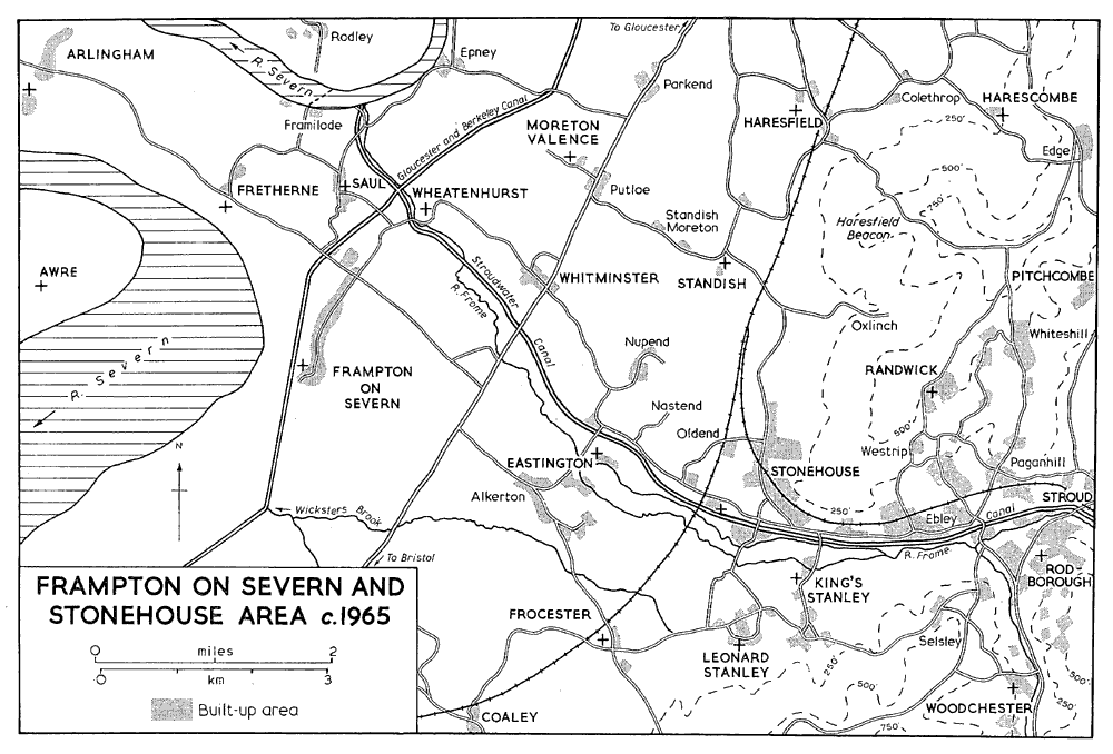
Frampton-on-Severn and Stonehouse area c. 1965
The divided river and its tributary brooks made the provision and maintenance of bridges a frequent item of expenditure. A bridge called Stony Bridge was mentioned in 1378, (fn. 92) and an order for repairs to Honey, Martin's, and Smith's Bridges was made in 1439. (fn. 93) Smith's Bridge may have been that later called Meadow Bridge carrying the main road over the Frome west of Churchend, for in 1464 responsibility for the repair of one end of it lay with John Breadstone, lord of the Alkerton manor of Amey Court, and of the other end with the bailiff of Eastington manor. (fn. 94) Horsenayle Ford mentioned in 1448 was perhaps where the Churchend-Millend road crossed one of the branches of the river. (fn. 95) Sparcroft Bridge in Nastend Lane was recorded c. 1552, (fn. 96) and stone was provided to repair it in 1747. (fn. 97) Oldbury Bridge, carrying the road to Nupend and Westend over the brook at Chippenham Platt, was mentioned in 1615 when the inhabitants of the two hamlets were said to be responsible for its repair. (fn. 98) In 1625 it was planned to build a bridge at Sil brook, evidently on the Westend-Whitminster road. (fn. 99) In the early 18th century the main road running north from Alkerton was carried by Meadow Bridge over the Frome and by a smaller bridge over the cut to the north; the road from Millend to Churchend was then carried by a bridge south-east of the church over the main northern stream of the Frome, but it crossed the cut to the north by a ford (fn. 100) until 1790 when a bridge was built there. In 1790 it was also decided to build a bridge over the southern stream of the Frome at Millend. (fn. 101) Meadow Bridge and the smaller bridge on the north were replaced by concrete structures in 1908, and Pike Bridge over the canal was replaced in 1924. (fn. 102)
Fifteen taxpayers were assessed in the parish in 1327. (fn. 103) There were c. 234 communicants in 1551, (fn. 104) and 56 households in 1563, (fn. 105) In 1650 there were said to be more than 80 families, (fn. 106) and c. 1710 a population of c. 450 in 100 houses. (fn. 107) About 1775 the population was estimated at c. 767; (fn. 108) it had risen to 988 by 1801 and a steady rise continued during the earlier 19th century to 1,886 in 1851. The population then fell steadily to 1,138 in 1931; there was then a slight rise to 1,399 by 1961. (fn. 109)
From the later 16th to the beginning of the 19th century the Stephenses, who had a large estate, were the leading family in Eastington. (fn. 110) In the 19th century the cloth manufacturers Charles Hooper and his son Charles Henry Hooper (fn. 111) played a dominant role in the parish. Both gained a reputation for a paternalistic attitude towards their workpeople, and were particularly concerned by the effects of beershops. (fn. 112) It was probably at Charles Hooper's instigation that the select vestry, of which he was a member, in 1834 offered a reward to anyone laying information against beershop-keepers who encouraged drunkenness or acted illegally; (fn. 113) his son opened a temperance hall in Alkerton, and a drinking-fountain combined with a signpost which he erected in the centre of the village to mark the Jubilee of 1897 was intended, according to tradition, to deflect custom from the near-by 'King's Head'. He also encouraged education and attendance at church or chapel among his employees. (fn. 114) There were two public houses and 23 beershops in the parish in 1838; (fn. 115) in 1891 there were 9 public houses. (fn. 116) A village hall at Alkerton was built by the Bush family of Eastington Park in 1927. (fn. 117)
During the siege of Gloucester in 1643 there was an outlying garrison of parliamentary troops at Eastington, (fn. 118) perhaps occupying the manor-house, then the home of Nathaniel Stephens, a supporter of Parliament. (fn. 119) The tradition that marks on the church tower were caused by cannon fire at that period, (fn. 120) was supported by the discovery of a cannon-ball in the near-by brook in 1967. (fn. 121)
Robert Stephens (1665-1732), a son of Richard Stephens of Eastington (d. 1678), was one of the founders of the Society of Antiquaries of London in 1717, and in 1726 was appointed historiographerroyal. (fn. 122)