A History of the County of Warwick: Volume 8, the City of Coventry and Borough of Warwick. Originally published by Victoria County History, London, 1969.
This free content was digitised by double rekeying. All rights reserved.
'The City of Coventry: Introduction', in A History of the County of Warwick: Volume 8, the City of Coventry and Borough of Warwick, (London, 1969) pp. 1-23. British History Online https://www.british-history.ac.uk/vch/warks/vol8/pp1-23 [accessed 23 April 2024]
In this section
INTRODUCTION (fn. 1)
THE CITY OF COVENTRY,
formerly in Knightlow Hundred, is situated in the north-east of the county of Warwick and on the south-east fringe of the region once covered by the Forest of Arden. The centre of the city lies on a slight eminence which rises to its highest point just south of Holy Trinity Church. To the north the ground falls away fairly steeply, rather less so to the west and east, and very gently to the south; this convex site is itself in a shallow basin, with a range of hills to the north-west and west and sporadic hills to the north-east. (fn. 2) The greater part of the modern city is on Permian Breccia and Sandstone, with a ridge of Triassic Keuper Sandstone giving place to Keuper Red Marls on the eastern side. (fn. 3) The whole area is well watered, for the River Sherbourne (now largely carried in culverts) meanders through the western, central, and eastern parts of what was the medieval city and is joined from the north by Radford Brook, or 'the water from Hill Mill'. Until recent times the Sherbourne with its mill streams, Radford Brook, and the Endemere (later Springfield Brook) (fn. 4) which passed through Swanswell Pool, formed a network of small waterways. The River Sowe, which crosses the southeastern quarter of the modern city from north-east to south-west, is joined by the Sherbourne at a point 2 miles south of the city centre, and itself flows into the River Avon near Stoneleigh, outside the city boundary. (fn. 5) Swanswell Pool (still existing), St. Osburg's Pool (the site of which was later marked by Pool Meadow), (fn. 6) and Bablake were low-lying watery or marshy areas. Frequent references in medieval deeds (fn. 7) to pieces of land called mora suggest that marshy land was a common feature.
Coventry lies within the triangle formed by the Fosse Way, Watling Street, and Rycknield Street, (fn. 8) 6 miles from the Fosse Way at its nearest point, 9 from Watling Street, and 17 from Rycknield Street. (fn. 9) By the 12th century streets ran out of the town to the north, east, south-west and possibly south-east and all, except the southern exits, had their suburbs. (fn. 10) This suggests that Coventry was already an important road centre, a supposition confirmed by the presence of bars at these exits in the 13th century (fn. 11) and by the building of the five most important gates there in the 14th century. Certainly by the middle of the 14th century it was the centre of a network of roads linking it with Worcester, Holyhead, Leicester, and London and by the 16th century at the latest the main coach road from London to Holyhead passed through the city. (fn. 12)
In 1768 the Coventry Canal Company began to cut a canal from Coventry to Fradley Heath; this was later linked to the Birmingham and Fazeley Canal and so to the Grand Trunk Canal on the north-west; on the east it was linked to the Oxford Canal and so to the Grand Union Canal and the Grand Junction Canal, making the city accessible by water from London, Liverpool, Manchester, Oxford, and elsewhere. (fn. 13) Coventry is not an important railway centre. A line from London to Birmingham passes through the city, the station having been opened, with the line, in 1838; branch lines serve Kenilworth and Leamington Spa, and Nuneaton. (fn. 14)
The complexities of the city's history and of the inter-relation of its members were the outcome of two episodes of fundamental importance. In the early 12th century the place was divided into two 'halves', the Earl's Half and the Prior's Half. In 1451, however, the 'halves' were reunited by the creation of the county of the city of Coventry which, for a period of nearly 400 years, absorbed the neighbouring communities. These episodes had farreaching effects on the administrative and economic development of the city. It is therefore desirable that at the outset they and other significant aspects of Coventry's history should be described in outline.
Before the making of the Domesday Survey there is no recorded mention of any individual place in the district of Coventry except Coventry itself, although it is clear from the evidence of place-names that many of the surrounding hamlets were, like Coventry, of Saxon origin. (fn. 15) About 1043 a Benedictine house, consisting of an abbot and 24 monks, was founded there by Leofric, Earl of Mercia, and the Countess Godgifu (Godiva), his wife. (fn. 16) It is highly probable that the whole of Coventry belonged to Godiva in her own right, (fn. 17) and that the abbey was founded within her territories and was endowed by Leofric with lands in Warwickshire and elsewhere. (fn. 18) Leofric died in 1057 (fn. 19) and Godiva in 1067. (fn. 20) In 1086 the lands which she had held were specified as Coventry (5 hides) and Ansty and Foleshill (9 hides) (fn. 21) and were then being farmed of the king by one Nicholas. (fn. 22) If the hide as a unit of assessment (fn. 23) was in this area about 200 acres, as seems probable, (fn. 24) then the area of Coventry in 1086 was about 1,000 acres. This figure may be compared with the 200 or so acres enclosed within the 14th-century walls (fn. 25) and with the area of about 1,000 acres contained by the boundary described in Richard II's charter of 1399, which included the suburbs then existing. (fn. 26) The abbey's endowments in the neighbourhood of Coventry were distinguished in 1086 as Binley and the greater part of Coundon and of Sowe. (fn. 27)
There is thus no evidence in Domesday that the abbey then held any lands, apart from its own precinct, within Coventry. (fn. 28) Soon after 1086 the whole city was granted to the earls of Chester, (fn. 29) but by 1113 the priory (as the abbey had become between 1095 and 1102) was claiming a 'half' of Coventry (fn. 30) later known as the Prior's Half. The rest of the town remaining to the earls of Chester formed part of what later was called the Earl's Half. Within the town the two halves were divided, according to Earl Hugh (II)'s charter to the priory of c. 11611175, (fn. 31) by a line running along the east-west axis of the town. The Prior's Half lay to the north, excluding the castle, and the Earl's Half lay to the south. Both 'halves', however, extended beyond the area later contained by the city walls. A chapel dedicated to Holy Trinity existed in the early 12th century (fn. 32) in the Prior's Half, and it is probable that the church of the Earl's Half, St. Michael's, was in existence at the same date or soon afterwards. Later descriptions of the bounds of the parishes (fn. 33) show that they followed within the town approximately the line of the boundary between the two halves with little variation through the centuries until St. John's parish was carved out of St. Michael's in 1734. (fn. 34)
The prime mover in the priory's acquisition of so extensive a part of the city was Bishop Robert de Limesey. He had moved the seat of his diocese from Chester to Coventry, and had laid hands on the abbey, making it a cathedral priory and himself as bishop becoming the titular abbot. In either 1107 or 1111 he substantiated before the king his claim to liberties and customs within and without Coventry. From the time when Robert officially moved his see to Coventry in 1102 until the time when he proved his claim, the Earl of Chester was a minor: in 1111 he was still only seventeen. After Bishop Robert's death in 1117 the monks took advice from Westminster and produced their series of forged charters which included Leofric's supposed foundation charter and confirmations of his grant by Edward the Confessor and Pope Alexander II (106173), dated 1043. They took the opportunity of inserting clauses which would preserve their independence against Robert's successors as bishops of Coventry. A second series of forgeries was produced in the late 1120s or early 1130s, and c. 1147 the priory obtained Stephen's confirmation, thus making doubly secure a position already accepted by both king and pope.
The division into 'halves' resulted in a prolonged period of rivalry between the priory and the lay lords of the Earl's Half, whose seat came to be the manor-house of Cheylesmore on the southern side of the town. (fn. 35) At first the priory enjoyed the greater power and prosperity but after the mid 13th century its supremacy began to decline in the face of increased hostility from the tenants of the Earl's Half and later the determined opposition of Queen Isabel who came into possession of the manor of Coventry, now called the manor of Cheylesmore, in 1330. From 1334 onwards she secured or made a number of grants in her tenants' favour culminating in the important charter of 1345. (fn. 36) In the following year the town acquired the leet jurisdiction of the manor, said in 1355 to extend over the following vills and hamlets round Coventry, covering about 15,000 acres: Radford, Keresley, Foleshill, Exhall, Ansty, part of Sowe, Caludon, Wyken, Henley, Wood End, Stoke, Bigging, Whitley, Pinley, Asthill, part of Stivichall, Horwell, Harnall, and Whoberley. (fn. 37) In 1355 a particularly bitter phase in the struggle with the priory was brought to an end by a settlement, embodied in a document known as the tripartite indenture, which marked a notable triumph for the queen and the corporation. By its terms the area of the Prior's Half and the prior's judicial rights were greatly reduced, most of the latter being vested in the mayor and commonalty. (fn. 38)
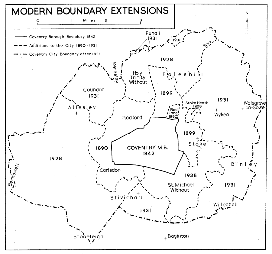
Modern Boundary Extensions
The creation of the county of the city in the mid 15th century, which re-united the two 'halves', introduced the second fundamental episode in the city's history. The claim that, because of its size and importance, Coventry occupied a special position in the county of Warwick had apparently first been made during the 14th century. (fn. 39) Eventually, in 1451, this claim was satisfied by the incorporation by royal charter of the county of the city, separate from the rest of Warwickshire. Besides the city of Coventry itself the county comprised all the localities which had been listed in the tripartite indenture; of the outlying parts of Holy Trinity parish it excluded, as had the tripartite, the hamlets of Coundon and Willenhall. (fn. 40) The version of the charter recorded in the Coventry leet book also mentions Shilton, while omitting the parts of Sowe and Stivichall; (fn. 41) the version entered on the charter roll omits Shilton but includes the parts of Sowe and Stivichall. (fn. 42)
The county of the city was in existence for nearly 400 years. It survived the passing of the Municipal Corporations Act of 1835 and remained for a time co-extensive with the newly-created municipal borough, but the grave disadvantages experienced by the inhabitants of the county of the city while under the corporation's jurisdiction, both before and after 1835, provoked them to challenge the corporation's authority in 1836 by refusing to pay the county rate. After six years of litigation (fn. 43) the corporation lost its suit; in 1842 the charter of 1451 was annulled, and the county of the city was dissolved (fn. 44) and re-absorbed into the administrative structure of Warwickshire. The large parish of Foleshill became the head of a poor-law union (and subsequently of a rural district) which included the parishes of Ansty, Exhall, Stoke, Sowe, and Wyken, and the hamlets of Keresley (a detached part of St. Michael's parish) and Willenhall (a detached part of Holy Trinity parish). The parish of Stivichall was annexed to Warwick Union, and the hamlet of Coundon (Holy Trinity parish) was placed in Meriden Union. (fn. 45) The remaining parts of St. Michael's and Holy Trinity parishes were still united for poor-law purposes and consisted of an urban area of 1,486 a. forming the new municipal borough and a rural area lying outside it. (fn. 46) The city's status remained unchanged until in 1888 it became a county borough. (fn. 47)
The question of the enlargement of the city boundary as a solution for disputes over sewage disposal was raised as early as 1874. (fn. 48) The first extension took place in 1890 when part of the rural area of Coventry Union was added to the borough. (fn. 49) The districts involved were Earlsdon (part of the ancient hamlets of Asthill and Horwell), Radford, and land in the neighbourhood of Red Lane. (fn. 50) The area of the city was thus increased by 1,607 a. to 3,093 a. (fn. 51) Under the Local Government Act of 1894 the civil parishes of St. Michael and Holy Trinity were subdivided: those parts already in the borough became Holy Trinity Within and St. Michael Within (which in 1900 were consolidated to form one civil parish of Coventry); the rural areas became Holy Trinity Without and St. Michael Without, and together made up Coventry Rural District. (fn. 52) In 1899 the borough was further extended to 4,147 a. by the inclusion of 1,054 a. of Foleshill and Stoke. (fn. 53)
There was no further expansion until 1928 when, by an Act of the previous year, Coventry Rural District was abolished, and the civil parishes of Holy Trinity Without (588 a.), St. Michael Without (1,295 a.), Stoke (449 a.), and Stoke Heath (formed out of Wyken civil parish in 1920) (fn. 54) (74 a.), and parts of Foleshill (1,279 a.) and Sowe (by then known as Walsgrave-on-Sowe) (8 a.) were drawn into the expanding county borough, together with parts of Allesley (871 a.), Berkswell (291 a.), and Coundon (36 a.) from Meriden Rural District, and parts of Stivichall (193 a.) and Stoneleigh (3,596 a.) from Warwick Rural District. The city's area thus rose to 12,827 a. (fn. 55) In 1932, by an Act of 1931, further parts of Allesley (177 a.), Coundon (959 a.), Foleshill (479 a.), Stivichall (545 a.), and Stoneleigh (75 a.) were taken into the city, together with parts of Binley (793 a.), Exhall (40 a.), Keresley (101 a.), Walsgraveon-Sowe (1,255 a.), Willenhall (464 a.), and the rest of Wyken (1,263 a.) from Foleshill Rural District, and of Baginton (159 a.) from Warwick Rural District. As a result of this extension, which brought the total area of the city up to 19,137 a., Foleshill Rural District was extinguished, as were also the civil parishes of Coundon, Exhall, Foleshill, Stivichall, Walsgrave-on-Sowe, Willenhall, and Wyken. (fn. 56) Some minor changes around the boundary of the city resulted in a net gain of 4 a. in 1956, (fn. 57) by which time the county borough had re-absorbed much of the former county of the city, together with portions of five additional parishes. In 1965 1,114 a. representing parts of Bedworth Urban District, Meriden Rural District, Rugby Rural District, and Warwick Rural District were added to the city. At the same time 120 unpopulated acres of the city were added to Rugby Rural District and Warwick Rural District. (fn. 58)
That part of the present volume which is devoted to Coventry covers the area of the two ancient parishes (Holy Trinity and St. Michael's) with all their outlying parts and the entire former county of the city with the exception of Exhall and Shilton. Accounts of these two parishes and of the five of which parts are included in the modern county borough but which had no ancient connexion with the city (fn. 59) have been given in two previous volumes of the History. (fn. 60)
POPULATION.
In 1086 there were in Coventry, within the 5 hides described in the Domesday Survey, 7 serfs in demesne, 50 villeins, and 12 bordars. (fn. 61) This small and undeveloped community was to become, in less than 300 years, one of the most important cities in the kingdom, giving place, it has been suggested, only to London, Bristol, and York. (fn. 62) The poll tax was paid in 1377 by 4,817 people. (fn. 63) In 1520, at a time of dearth, a count was made and the total population was given as 6,601. (fn. 64) A muster book of 1522 gives a total of about 1,400 persons including some 165 widows and single women and 48 priests. (fn. 65) What appears to be a complete household census was taken in 1523, at a time of economic depression. A preliminary examination of the returns suggests a total population of c. 5,700 persons. Of these about 1,500 were children whose age-limit is not defined. (fn. 66) Apparent increases in population between 1520 and 1523 in Jordan Well and Street wards (from 354 to 448 in Jordan Well and from 627 to 878 in Spon Street) may be explained by the supposition that these wards were seriously under-counted in 1520, since in the other eight wards there was a drop in population of 22.3 per cent in the same period. Further evidence of this decline is provided by the total of 565 houses in the city which were standing empty in 1523. (fn. 67)
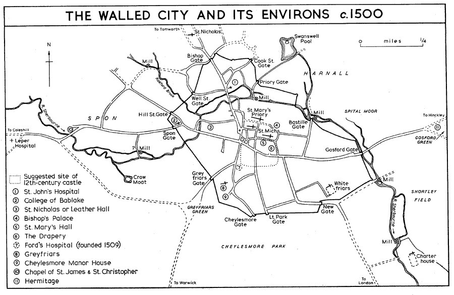
The walled city and its environs
The burgesses of Coventry, when appealing to the Privy Council against the dissolution of the guilds and chantries in 1548, claimed that the population was about 11,000 to 12,000, (fn. 68) probably an exaggerated figure. The chantry returns of 1547 give the population of the parishes of St. Michael and Holy Trinity in round figures of 3,000 and 4,000 respectively, (fn. 69) and these figures, too, may be slightly exaggerated. An episcopal return of 1563 gives the number of households in St. Michael's parish as 503. The return for Holy Trinity parish, however, gives only 49 households, a figure which, in view of the 1547 totals, seems quite unrealistic. (fn. 70) A local census, taken at a time of scarcity in 1587, gives the total of men, women, and children in the city as 6,502. (fn. 71) Detailed lists of 1594 and 1595, apparently rate assessments, exist for St. Michael's parish only and give the numbers of children, servants, and apprentices in each household. It is not certain, however, that all households were included. The total given for 1594 is 2,219 persons, and for 1595 (when one side of Earl Street was omitted) 2,127. (fn. 72) In 1644, when the city was in danger of being besieged by royalist forces, 'the people were numbered to make provision and they were 9,000 souls', (fn. 73) but this may have included fugitives from the surrounding countryside. Neither the so-called Compton Census nor the hearth-tax assessments appear to give realistic figures: the former refers to only 1,871 adults in 1676, (fn. 74) and the largest number of names given by the latter is 959 in about the same year. (fn. 75) In 1694, when the Marriage Duties Act caused another local census to be taken, the total population was 6,710. (fn. 76)
There is no such detailed local information for the 18th century, but in 1719 the inhabitants were described as 'of late years become very numerous'. (fn. 77) This statement is borne out by the figures of 13,920 and 12,117 calculated for 1737 and 1750 respectively. (fn. 78) The scale of subsequent increases can be judged by the Census of 1801, which gives the population of the city as 16,034 and of the county of the city as 5,547. (fn. 79) The rise in population during the 18th century must be attributed to an influx of people into the city, for a comparison of baptisms and burials shows that natural increase cannot explain it. (fn. 80) The excess of burials over births was greatest in 1801, when there were only 395 births compared with 623 burials, (fn. 81) but this situation was noticeably changing during the first twenty years of the 19th century. (fn. 82)
People flocked into the city, drawn by the development of ribbon weaving and watch making. By 1851 the population of the city was 36,208. The great slump in the weaving trades in the 1860s is reflected, however, in a decrease of over 3,000 in the population of the municipal borough between 1861 and 1871; numbers decreased in all the parishes of the city and former county of the city, but the greatest decline was in St. Michael's parish and in Foleshill. (fn. 83) The succeeding decades saw the rise of the bicycle and motor industries and a corresponding rise in population, so that the figure for 1891 some 53,000 was doubled by 1911 (106,431 including St. Michael Without and Holy Trinity Without). (fn. 84) Aeroplanes, machine tools, and munitions brought in factory workers from London and other parts of the country, and from Ireland, to help to swell numbers in the 20th century. In 1921 the population was 133,287 (again including St. Michael Without and Holy Trinity Without), and in 1931 the enlarged city had 167,083 inhabitants. (fn. 85) By 1940 the population had increased to 242,000, (fn. 86) and after some reduction during the war years this figure had by 1947 been surpassed. (fn. 87) In 1951 the population of the city, as enlarged in 1932, was 258,245, (fn. 88) and in 1961 305,060. (fn. 89)
TOPOGRAPHICAL DEVELOPMENT TO 1940. (fn. 90)
It is almost certain that Coventry first came into existence as an Anglo-Saxon settlement. Although Dugdale implies a pre-Roman origin by his derivation of the name Coventry from 'Convent' or 'Cune' (an alternative name for the River Sherbourne) and 'tre' (a British word for 'town'), (fn. 91) finds of prehistoric and Roman remains made in the 18th and later centuries in Coventry itself and in its immediate neighbourhood are either suspect (fn. 92) or at best too sporadic to provide evidence for any definite settlement in the area. (fn. 93) The prevalence of the wooded country of the Forest of Arden, the infertile soil, and the comparatively low-lying nature of the site, together with its distance from any Roman road or well-attested Roman or pre-Roman settlement, suggest that it was not a centre of habitation during these periods. However, the site, lying as it did within a bend of the River Sherbourne (the name is Old English), (fn. 94) on the very fringe of the Forest of Arden, in a band of fairly open land between the forest and the River Avon, (fn. 95) was well suited to settlement by the Anglian and Saxon invaders who are known to have reached this area at a fairly early date and established the pagan Saxon cemetery of Baginton which is only 2 miles south of Coventry. (fn. 96) The name Coventry is itself almost certainly of Old English origin; the accepted derivation is Cofan treo meaning 'Cofa's tree', (fn. 97) which is taken to denote a boundary tree marked by Cofa, the head of the invading tribe. The word 'Cofa' may, however, refer to the shallow basin in which the place lies. (fn. 98) A further witness to its Saxon origin is the prevalence of the ending 'ley' (leah a wood or clearing) in the names of its hamlets and nearby parishes: 'Bisseley', Henley, 'Olney', Pinley, Shortley, 'Tackley', Whitley, Whoberley, Allesley, Binley, and Canley. Other Old English place-names are: Caludon, Cheylesmore, Coundon, Finham, Fletchamstead, Foleshill, Harnall, Hearsall, 'Horewell', Spon, Stivichall, Stoke, Whitmore, Willenhall, and Wyken. (fn. 99)
The church of St. Nicholas, subsequently a chapel of Holy Trinity, (fn. 100) may (c. 1003) have been the church of one of the early settlements of Coventry. (fn. 101) It is also possible to trace back to the 14th century (fn. 102) a persistent tradition that a nunnery was founded in Coventry by St. Osburg, its abbess, in the late 10th century, that this nunnery was destroyed by the Danes under Edric the Traitor in 1016, and that Leofric and Godiva used the same site for the foundation of their Benedictine house c. 1043. (fn. 103) This latter house, according to one version of the forged foundation charter of Leofric (c. 1130), was dedicated to St. Mary, St. Peter, St. Osburg, and All Saints. (fn. 104) The nunnery completely disappeared but the observance of St. Osburg's day survived: in 1408 Bishop John Burghill ordained that in the city and suburbs of Coventry there should be a special feast of St. Osburg the Virgin and special services held in her honour; (fn. 105) her feast is celebrated in the Archdiocese of Birmingham on 30 March (fn. 106) and her shrine 'of copper and gilt' was to be found in the priory church of Coventry before the Dissolution. (fn. 107) The story of a Danish incursion is borne out by the strong Scandinavian element in personal names, both christian and surname, persisting in Coventry in the 12th and 13th centuries: Anketill, Lef, Sweyn, Grondrak, Haldeyn, Hakon, Thorlawiston, Rorik, Brunhalling, Skathelok, Le Northerne, Wengha, Gundred, and Porstein and its English form Thurstan; (fn. 108) the Old Swedish element Kaerer appears in the place-name Keresley; (fn. 109) Bigging, near Stoke, is of Old Scandinavian origin. (fn. 110) Moreover, the Hox Tuesday games, which were held in Coventry into the 16th century, were said to have commemorated either the death of Hardicanute or the defeat of the Danes. (fn. 111)
It is as yet impossible to locate with certainty the first settlement of Coventry. Dugdale thought that the most ancient site was on the hill outside Bishop Gate to the north and he cited in evidence the then recent discovery of the 'foundation of much building there' and the presence of St. Nicholas's churchyard; (fn. 112) the name Barr's Hill also gave rise to the supposition that this was the site of prehistoric or Saxon earthworks (fn. 113) but a deep cutting made in connexion with road works in 1965 revealed no trace of human occupation on this site. (fn. 114) St. Nicholas's Church (probably already in existence for at least a century) was the centre of a flourishing suburb in the 12th century (fn. 115) and this would account for the discovery of buildings mentioned by Dugdale. The suburb probably developed, however, out of an early settlement, for Middleborough Terrace (laid out by 1862) (fn. 116) is on the site of a plot known in 1545 as Medelborowe, (fn. 117) and nearby were fields called Bannepece and Stripe. (fn. 118) There was also a 12th-century suburb at Spon on the west. (fn. 119) The accepted derivation of the name Spon is from the Old English Spann meaning a hand's breadth, (fn. 120) but the river valley and the wooded area suggest that it is perhaps from the Old English spn meaning a shaving or chip, or its Old Norse equivalent spnn, (fn. 121) the place where roof shingles were made. (fn. 122) Another 12th-century suburb lay beyond Gosford, with the common field of Coventry lying to the north. (fn. 123) Further north still were the 12th-century manor and vill of Harnall. (fn. 124) It might be argued that if the first settlement had been near Barr's Hill it would have avoided the marshy ground of Bablake, the pool later known as St. Osburg's Pool, and the low-lying 'moor' between them skirted by two branches of the River Sherbourne. But a settlement in the wooded river valley at Spon or in the well-watered Gosford area would have been more in character with the known practice of the Angles and Saxons. If the tradition that a Saxon nunnery dedicated to St. Osburg stood on the same site as the later Benedictine abbey has any validity, then Saxon occupation must be assumed very near the centre of the medieval and of the modern city. The abbey site is partially enclosed by the River Sherbourne on the north and rises fairly steeply to the south. If Leofric and Godiva had any dwelling within Coventry it probably lay due south of the abbey. (fn. 125) It would therefore have been natural that the centre of habitation should move in from the east or west or down from the northern eminence nearer to the abbey precinct and the protection of the overlord. Archaeological evidence for Saxon occupation has so far been scanty and inconclusive. A fragment of a carved cross-shaft, thought to date from the late 10th century, was found in the 1930s below the present level of Palmer Lane, where it had been incorporated in earlier street paving; it has been suggested that this cross may originally have stood in the forecourt of St. Osburg's nunnery. (fn. 126) In 1965 a Saxon brooch and a fragment of 'Stamford' ware were found on the north side of Corporation Street. (fn. 127) Traces of early buildings, discovered at considerable depths near the centre of the city in 1934, may be of Saxon origin and, if so, would provide additional evidence of a settlement in this area. (fn. 128)
For the 12th and particularly for the 13th centuries there is considerable evidence in deeds for street names and for descriptions of properties lying in those streets; (fn. 129) information of the same kind is contained in the priory rental and cartulary of c. 1411. (fn. 130) Material from these sources is included in the alphabetical list of streets in the present volume. (fn. 131) In its basic topography the city changed hardly at all from the 14th century, when the walls were begun, until its industrial expansion in the 19th and 20th centuries. The main outline of Coventry's street plan in the later Middle Ages was, therefore, to persist for nearly 600 years. The most striking feature of this plan (fn. 132) was the important axial road, leading westwards towards Coleshill and the north-west of England, and eastwards towards Hinckley and Leicester. During its course through the builtup area this thoroughfare was nearly a mile and a half long, stretching from the suburb of Spon outside Spon Gate on the west to Gosford Green beyond Gosford Gate on the east. Its various sections were known as Spon Street, Fleet Street, Smithford Street, High Street, Earl Street, Jordan Well, Gosford Street, and Far Gosford Street. The River Sherbourne lay mostly to the north of this road, but was three times crossed by it, at Spon Bridge in the extreme west, at Smithford Bridge, and at Gosford Bridge. At the centre of the city was the near crossroads where Broadgate, High Street, Greyfriars Lane, and Smithford Street met. From Broadgate the main exit to the north was by way of Cross Cheaping, St. John's Bridges (now Burges), Bishop Street, and Bishop Gate, beyond which roads fanned out to Radford, the suburb of St. Nicholas, and towards Nuneaton. A central outlet from the city on the south side was precluded by the presence of Cheylesmore manor-house and its park. Instead the road to Warwick led in a south-westerly direction by way of Greyfriars Lane, Warwick Lane and Greyfriars Gate, while Much Park Street ran south from Jordan Well and then swept eastwards to skirt the park and to become the London road outside New Gate. An intermediate street, Little Park Street, led southwards from the junction of High Street and Earl Street to the park itself. To the north-east of Broadgate was a network of lanes leading to the churches of St. Michael and Holy Trinity and to the Benedictine priory; the Great Butchery and the Little Butchery lay immediately outside the west gate of the priory precincts. Further north, beyond the river, were Cook Street and St. Agnes Lane. To the north-west of Broadgate lay West Orchard and Well Street with the river between them, while at Bablake, just inside Spon Gate, Hill Street branched from Fleet Street in a north-westerly direction.
It is clear from the evidence of corporation deeds that most of the streets lying north of the east-west spine road had been built up at an early date, so that when the city wall was erected in the later 14th century there was considerable disturbance of properties on its northern perimeter. (fn. 133) Spon Street also appears to have been built up with houses at least as far as Barras Lane. (fn. 134) South of Gosford Street, however, there was enough open land for the Carmelites to be granted 10 a. when their house was founded in 1342. (fn. 135) There are other indications that, at this time, the built-up area was moving southwards. Before the middle of the 14th century Queen Isabel had rented as many as 88 building plots in Cheylesmore Park to citizens of standing in the city. (fn. 136) Some of these plots lay in Much Park Street and Little Park Street, where, in spite of later infilling, their outlines could still be recognized in the 20th century. This lay-out has been called 'Coventry's first piece of town planning'. (fn. 137)
Outside the walls the western suburb of Spon stretched from Spon Gate to Spon Bridge with the 12th-century leper hospital and its chapel of St. Mary Magdalen beyond. The leper hospital was founded in Henry II's reign. (fn. 138) It is said subsequently to have had its own tenants, and courts, (fn. 139) but in 1250 it was part of the manor of Cheylesmore. (fn. 140) By 1280, however, it was in the hands of the priory (fn. 141) and in 1316 the prior granted the 'manor' of Spon with its chapel and lands to one Nicholas Pihod. (fn. 142) Nevertheless, when the manor of Cheylesmore came to the Crown later in the century Spon and its hospital appear to have been part of it. (fn. 143) Yet Spon clearly had all the elements of an independent community at an early date. It was referred to as a vill in the early 13th century (fn. 144) and had its own common, fields, wood, mill, and waste. (fn. 145) Spon common field lay to the north of Spon Street, and 'Spon field' to the south. (fn. 146) Spon wood probably lay north of Spon End; (fn. 147) the position of Spon waste cannot be fixed. A croft called Bannecroft lay northwards towards Spon Cross, which may have been at the top of Hill Street. (fn. 148) Spon Bridge was in existence in the late 13th century. (fn. 149) In 1411 there were houses near the bridge; on the north there was a stone tenement with a long orchard and on the south three cottages called le Cadelond.
To the north of the city, also outside the walls, were the suburbs of St. Nicholas and Harnall, (fn. 150) while Far Gosford Street, between the Gosford bridges and Gosford Green, represented the fourth of Coventry's medieval suburbs. South of the highway was Shortley Field and north of it was the common field of Coventry, Harnall Field, which stretched as far as Gosford Green. (fn. 151) Further north was Harnall Quarry. (fn. 152) A ford was replaced by Gosford bridges over the Sherbourne and its tributary stream, the Springfield Brook, probably during the 13th century, for at the end of the century lands and tenements were being leased between the bridges, (fn. 153) known by the late 17th century as Dover Bridge (fn. 154) and Callice (Calais) Bridge. (fn. 155) A Harnall Bridge mentioned in 1434, 1604, and 1694 (fn. 156) may have been one of these under another name. It was more probably, however, a third bridge situated north of Far Gosford Street in Harnall Field, where the most important of the many small bridges over dykes and streams in the area mentioned in 1480 were situated. (fn. 157)
At the dissolution of the monasteries and of the guilds and chantries only two of Coventry's nine religious foundations, Bond's Hospital and Ford's Hospital, were allowed to remain. (fn. 158) Although there was much demolition of buildings on the sites of the dissolved houses, this great upheaval resulted in little change in the topography of the city. At the Whitefriars and the Charterhouse surviving buildings were converted into residences and the precincts became the private grounds of their owners. The site of the Greyfriars' house was left vacant, only the tower and spire of the church surviving. The church of St. John's Hospital became the home of the Free Grammar School and much of the land formerly attached to the hospital was not developed until the mid 19th century. Buildings belonging to the College of Bablake were used partly for a boys' hospital (later Bablake School) in 1560 and partly for the Bridewell in 1571. The ground occupied by the leper hospital at Spon End seems to have remained open except for its ruinous chapel, later converted into a barn. On the site of the Benedictine priory, however, a few houses were built in the 17th century and two new streets were formed across it, Hill Top and New Buildings or Priory Lane. (fn. 159)
A comparison between the map of medieval Coventry and a survey of the city made by Samuel Bradford in 17489 (fn. 160) demonstrates the persistence of its early lay-out. The presence of the wall was one factor in stabilizing the street plan, limiting as it did any outlets from the town to those provided by the medieval gates. Demolition of the wall was begun after the Restoration but not completed, and it was only in the late 18th century, when the roads through Coventry became important for coaching traffic, that the principal gates were cleared away. (fn. 161) At this time the streets within the walls were still essentially those of the medieval town, many of them narrow, winding, and ill-paved. In the last decade of the century the north side of Earl Street and the east side of Burges (formerly St. John's Bridges) were rebuilt, (fn. 162) but elsewhere the streets were often obstructed and overhung by the irregular frontages of early timber-framed houses. As the result of an Act of 1812 (fn. 163) various improvements were put in hand, the first of which was the construction of Hertford Street. This led from Broadgate to Greyfriars Green, (fn. 164) providing a better entry than the narrow access to the Warwick road through Greyfriars Lane and Warwick Lane. Between 1820 and 1823 Broadgate was widened and its junction with Smithford Street was rebuilt. Fleet Street was also widened and gradients were reduced in Bishop Street, Gosford Street, and Far Gosford Street. (fn. 165) Soon afterwards, as part of the improvements to the main turnpike road from London to Chester, Birmingham New Road (now Holyhead Road) was built between Bablake and Allesley. (fn. 166)
By the early 19th century the steadily increasing industrial population of Coventry provided an even more pressing reason for topographical change. At the same time the persistence of Lammas and Michaelmas rights over most of the land round the western perimeter of the city placed a stranglehold on expansion. (fn. 167) Cheylesmore Park and Whitley Common lay to the south, while to the south-east was an entailed estate which could not be developed for building. (fn. 168) As a partial, if shortsighted, solution of the problem all available land within the city itself was brought into use for the erection of workers' houses. A few new streets were constructed across open ground Chantry Place in 1816, Union Street and Whitefriars Street in 1820 (fn. 169) but much of the development was forced to take place in lanes and yards, as well as in the long garden plots behind the existing houses. Many gardens were rapidly built up with parallel rows of small dwellings, often with weavers' workshops on their upper floors. Passages through or between the houses on the street frontages provided the only access to these crowded and often insanitary courts. William Reader, writing c. 1823, described the process: 'While . . . one portion of the inhabitants is widening the streets, another is engaged in the erection of small houses in every yard and garden where they can possibly be built, not regarding the fatal effects that may possibly arise from infectious fevers etc. in crowded habitations'. (fn. 170) Thus, hidden behind its principal streets, many of Coventry's future slums were created.
In 1828 the building of the so-called 'New Town' was begun at Hillfields to the north-east of the city, the only area then available for expansion; its new streets were largely occupied by ribbon weavers. (fn. 171) Houses were also being erected in and near Dog Lane (later Leicester Street and Swanswell Terrace), just north of the city wall. (fn. 172) An Act of 1845 (fn. 173) released a substantial area between the wall and Swanswell Pool, hitherto the property of Sir Thomas White's Charity. There Norton Street, Jesson Street, Ford Street, and other roads were laid out, and Hales Street was cut to connect them with Bishop Street and Burges. Three water mills within the city were cleared away in the 1840s, (fn. 174) making it possible to reclaim marshy land near the River Sherbourne which had been liable to floods; in 18567 the Pool Meadow area was opened up by the construction of Priory Street between Priory Row and Ford Street. (fn. 175) Spitalmoors, adjoining Hillfields on the south, was developed after 1855, giving an almost continuously built-up area from Harnall Lane in the north to Far Gosford Street in the south. (fn. 176)
Meanwhile to the west of the city, between Spon Street and Hertford Street, development had taken place in the 1820s along the north side of Summerland Butts Lane (later the Butts and Queens Road). After 1832 the land further north had been built up with streets of small houses and Crow Moat had been filled in. Poddy Croft, a patch of Lammas land to the east of Crow Moat, remained open as gardens until late in the 19th century. (fn. 177) Beyond Spon End a nursery garden at Chapel Fields, also part of Sir Thomas White's Charity lands, was laid out with streets of watchmakers' houses from 1846 onwards, (fn. 178) and further south, outside the Lammas and Michaelmas lands, the isolated watchmakers' suburb of Earlsdon was developed after 1853. (fn. 179) These western districts were officially designated a new ecclesiastical parish when St. Thomas's Church on the south side of Summerland Butts Lane was consecrated in 1849. (fn. 180)
Development immediately south of the city was of a different kind. In the early 19th century the new buildings in Hertford Street were occupied by banking houses and superior shops, while some good town houses had already been built in Warwick Row overlooking Greyfriars Green. (fn. 181) The gardens and open land of Cheylesmore Park, flanked on the east by Whitley Common and on the west by Stivichall Common, made this potentially an attractive residential area. Between the park and Whitley Common the new cemetery, opened in 1847, was so imaginatively laid out that it became a favourite promenade for the townspeople. (fn. 182) The only small houses in the district were three isolated terraces of railway cottages. The cutting of the railway across the park and the opening of Coventry Station beside Warwick Road in 1838 (fn. 183) did not immediately lead to industrial development nearby, and in general the siting of the railway never greatly influenced the pattern of the city's expansion. By 1863 a terrace of large houses, known as the Quadrant, had been built on a former orchard near Greyfriars Green. (fn. 184) This was followed by detached houses further south and by middle-class terraces in Queens Road. By the late 19th century, when building land on the high ground to the south of the railway became available, the character of the area as a superior residential suburb had been firmly established.
The Lammas and Michaelmas lands were at last inclosed in 1860 and 1875, and in 1890 and 1899 the first boundary extensions took place. (fn. 185) As Coventry spread, so the built-up area began to impinge on the surrounding villages and hamlets, detailed accounts of which are given in a separate section. (fn. 186) Expansion was particularly rapid to the north-east where the canal and the branch railway to Nuneaton attracted the building of factories, accompanied by streets of small houses. Soon after 1900 (fn. 187) many of the scattered hamlets in the large parish of Foleshill, formerly a ribbon-weaving area, were joined to Coventry by a continuous belt of builtup land on both sides of Foleshill Road. There was similar but more sporadic development along Stoney Stanton Road, leading north-eastwards to the colliery settlements at Alderman's Green and Hawkesbury. Building to the east of the city had spread as far as Swan Lane, almost linking it with Upper Stoke. The former residential suburb round Stoke Green was rapidly being engulfed by streets of small houses. Development had also begun on the former Boston estate to the south of Far Gosford Street and at the northern end of Cheylesmore Park. South of the railway large detached houses had been built along Warwick Road, while further west Earlsdon was expanding eastwards to meet the residential streets near Spencer Park. In the extreme west Chapel Fields was still an island of urban development, but much new building had taken place nearer the city which now extended as a continuous built-up area as far west as the branch line to Nuneaton.
By the First World War the urban area of Coventry was about 2 miles long from east to west and about 1 mile wide from north to south. In addition there was a great tongue of built-up land, mostly industrial in character, extending north-eastwards to include much of the former parish of Foleshill. Earlsdon, now joined to Chapel Fields by a solid block of streets north of the railway, formed another salient in the south-west. Partly because of sewage difficulties, (fn. 188) expansion was slower to the north-west, where Allesley and Radford were still separated from Coventry by fields, while Coundon and Keresley were districts of scattered farms with a few large houses in their own grounds. To the south some new residential streets, with a block of factories to the east of them had been built near the station on what was formerly Cheylesmore Park, but most of the park, together with Stivichall Common and Whitley Common, still formed a large tract of open land.
After the First World War a major contribution to the expansion of Coventry was made by corporation housing schemes, laid out for the most part at lower densities than the earlier terraced streets. The first estate, at Stoke Heath, had been started during the war itself to accommodate munition workers at the Ordnance factory in Red Lane. After 1925, when sewerage had been provided, large estates were built at Radford, and at Hill Farm further north. (fn. 189) Many estates were also built by private developers, one of the largest being on the site of Radford aerodrome. Later there was extensive building of this kind along Holyhead Road and Allesley Old Road as well as at Coundon and Keresley Heath. At Holbrooks, in the extreme north, a corporation estate was laid out just inside the city boundary in 1931, to be followed by much private development in the same area. A sewerage scheme for the Sowe valley to the east of Coventry was carried out between 1934 and 1937, (fn. 190) opening up the Ansty Road and Binley Road districts for development. By 1938 new building stretched from Stoke Heath in the north to Pinley in the south and extended nearly as far east as Walsgrave-on-Sowe. In the later 1930s corporation and private estates began to cover the southern half of the former Cheylesmore Park and the hitherto rural land at Stivichall. The War Memorial Park to the west of Stivichall had been opened in 1921 (fn. 191) and in 1926 the corporation had bought over 2,000 a. of land at Stoneleigh. (fn. 192) Here the spinneys which lined the Kenilworth road were preserved, development being allowed to take place behind them. This was mostly in the form of detached residences in large gardens, but a few streets of small houses were also built. To the extreme west of the city, beyond Fletchampstead Highway, there were large areas of private building on both sides of Tile Hill Lane before 1939, and corporation housing had been started at Canley to the south of the railway.
Between the wars the pattern of Coventry's growth was influenced not only by the availability of sewerage but also by the location of important factories which were built or enlarged on the outskirts. These were mostly connected with the motor trade and included the Humber works at Pinley and the Daimler works north of Radford (both established before the First World War), the Standard works at Whoberley, the Armstrong Siddeley aircraft works at Whitley, the telephone works at Stoke (later belonging to the General Electric Company), and the Dunlop works at Whitmore Park. (fn. 193) By the late 1930s the built-up area occupied by Coventry and its suburbs was nearly five miles in diameter from east to west and an equal distance from north to south. Nevertheless the city boundary, extended in 1928 and 1932, still included large areas of open farmland near its perimeter.
Meanwhile in the centre of the city there had been little essential change in lay-out for more than a hundred years. During the industrial rehabilitation of Coventry in the late 19th century former weaving factories and workshops had been taken over by cycle and light engineering firms; (fn. 194) subsequently new factories had been erected wherever sites could be found. The central area had thus become a jumble of cramped industrial premises, public buildings, crowded courts, and streets of timber-framed or small terraced houses all served by a largely medieval road system. The narrow shopping streets were forced to carry not only internal traffic but also the steadily increasing through-traffic brought by the main roads which converged on the city. One problem, not exclusive to Coventry, was the high value of the commercial sites along these streets, making the cost of drastic changes almost prohibitive. Only on the north side of Earl Street had it been possible to abolish the shops, set back the road frontage, and, between 1913 and 1917, to build the new Council House on a cleared site. (fn. 195) After 1930, however, a more comprehensive plan for slum clearance and street improvement was put in hand. The old houses and decaying courts at the south end of Well Street were cleared away, and Corporation Street, a wide new thoroughfare connecting Fleet Street at Bablake with Hales Street, was opened in 1931. (fn. 196) A continuation of the scheme was the construction of Trinity Street between Hales Street and Broadgate. This necessitated the demolition of Great Butcher Row and Little Butcher Row ancient streets with central gutters and overhanging houses and of parts of the narrow lanes leading off them. (fn. 197) To the north of Hales Street, where more slum property had been cleared, the surviving stretch of the city wall was given to the city by Sir Alfred Herbert in 1931, and an area on either side of it was laid out as a small park known as Lady Herbert's Garden in memory of the donor's wife. (fn. 198) Trinity Street, opened in 1937, gave a clearer exit north-eastwards from Broadgate, and it was hoped at the same time that much through-traffic would be diverted from Smithford Street and the congested central area by way of Corporation Street and Queen Victoria Road. Corporation Street was also intended to become a supplementary shopping area, but this plan never came to fruition, partly because it was too far from the city centre and partly because long-term development was interrupted by the outbreak of war in 1939.
A more lasting contribution to the problem of through-traffic was made by the completion in 1940 of the by-pass road to the south of Coventry. This has a dual carriageway and runs for over six miles in a north-westerly direction from Ryton Bridge near Willenhall to Allesley, diverting traffic from London to Birmingham and the north-west away from the city centre. (fn. 199)
THE AIR RAIDS OF 1940. (fn. 200)
The importance of Coventry as a centre of war production made it the target of German air raids in the Second World War. (fn. 201) In the early summer of 1940 the British chiefs of staff had told the Prime Minister that Germany could not gain complete air superiority without destroying both the Royal Air Force and the British aircraft industry particularly those essential sections of it at Coventry and Birmingham. (fn. 202) Attacks on the city were, therefore, to be expected, and sporadic raids were experienced by Coventry from the summer of 1940. (fn. 203) When, however, the R.A.F. interrupted Hitler's putsch-anniversary speech at Munich on 8 November 1940, (fn. 204) and attacked Berlin during the German leader's discussions with the Russian foreign minister, Molotov, on 12 and 13 November, Hitler gave orders for a crippling reprisal raid to be made on Coventry. (fn. 205)
This raid, on the night of 1415 November, was, however, more than a short-term act of revenge. From early September until mid November London had been the main target of German air raids. The attack on Coventry marked the beginning of a new phase of the enemy's air offensive, a phase designed to cripple British war production by a series of concentrated onslaughts on the chief provincial industrial centres. (fn. 206) After the raid the German propaganda services coined the verb coventrieren (to coventrate) with which to threaten the populations of other British cities with wholesale destruction. (fn. 207) Nevertheless, however widespread in the event was the damage caused by the attack, the prime objective of the German air force had not in fact been to terrorize the civilian population of Coventry but to put out of action the city's aircraft and other industries. German bomber crews were not told to make indiscriminate attacks on Coventry itself but had orders to attack particular targets, such as the Standard Motor Car Company's factory. (fn. 208)
Advantage at that time lay with the enemy bombers. British defences were weak and on the night in question had little positive effect. Only one German aircraft was destroyed. Some bombers, however, appear to have been deflected from Coventry for, according to German sources, of the 509 aircraft despatched to the city 60 failed to reach it. (fn. 209) The raiders were led by Kampfgeschwader 100, a 'pathfinder' unit using for the first time a special beam equipment known as X-Gert (or to the British as 'ruffians') to indicate the target area, (fn. 210) which anyway stood out in bright moonlight. The hail of incendiary bombs which fell in the early evening over a wide area, but particularly around the vicinity of the cathedral, marked the beginning of the attack and started fires which further illuminated the target area. High explosive bombs followed. According to German sources a total of 503 tons of high explosives and 881 incendiary canisters were dropped. Within an hour from the beginning of the raid the whole central area was burning fiercely, and though the fire services kept some control over the blaze for four hours or so the task later became impossible. By the early hours of the morning there were about 200 fires alight, while the presence of unexploded bombs and parachute mines added to the confusion. Many of the city streets became impassable and the difficulties of fighting the fires and carrying out relief operations were increased by the early failure of all telephone lines but one, the blocking of the railway lines to Birmingham, Leamington, Rugby, and Nuneaton, and by severe damage to gas and water mains. Civil defence services nevertheless continued in their task receiving reinforcements at dawn from groups brought to the city outskirts during the night. (fn. 211)
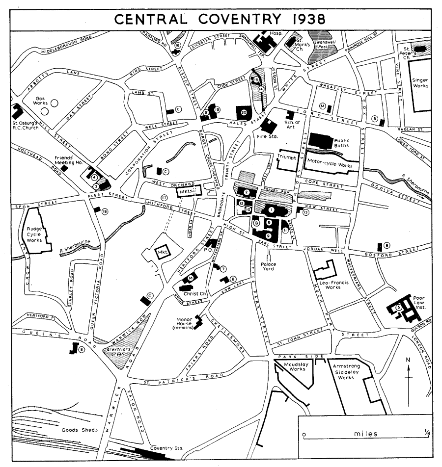
Central Coventry 1938
1. Cathedral Church of St. Michael. 2. Holy Trinity Church. 3. St. John's Church. 4. Bond's Hospital and Old Bablake School. 5. Remains of Whitefriars. 6. Old Grammar School. 7. Ford's Hospital. 8. St. Mary's Hall and Central Police Station. 9. Council House. 10. County Hall. 11. Drapers' Hall. 12. Gulson Library. 13. Provident Dispensary. 14. Remains of City Wall. 15. Lady Herbert's Homes. 16. Canal Office. 17. Site of Great Meeting. 18. Salvation Army Citadel. 19. Opera House. 20 New Hippodrome. Nonconformist Churches B. Baptist. C. Congregational. M. Methodist.
Whatever the original German intention the main attack fell on the city centre where the morning found in ruins the shopping area and many public and historic buildings, including the cathedral, Ford's Hospital, and the Gulson Library. Between 400 and 500 retail shops were put out of action. Total fatal casualties numbered 554, and a further 865 people were seriously wounded. (fn. 212)
Although the Germans did not immediately realize it the success of the raid was, from their point of view, limited. Their bombing was clearly imprecise and, although many factories did receive damage from direct hits, works buildings were generally less inflammable than domestic property. Twenty-one important factories, including twelve directly concerned with aircraft production, were badly damaged, but Coventry's war industry was only temporarily halted. Production suffered a total stoppage on 15 November, but this was the result as much of lack of gas and water services as of actual bomb damage to the factories. Lord Beaverbrook, Minister of Aircraft Production, spent all that day at Coventry, and on 16 November some factories began work again and a production rate of one-third of the normal was attained. (fn. 213) Within five days Coventry's factories were back to full production (fn. 214) and within two months the setback to the war effort generally had been amended. (fn. 215)
This recovery was undoubtedly due in part to the failure of the German air staff to follow up the first mass attack by others in quick succession. Weather on the night of 1516 November was unfavourable to the enemy and a mere eight aircraft reached Coventry dropping only a few bombs. Subsequently the German air force concentrated its offensive on other towns. (fn. 216) Thus time was given not only for industry to recover but for the general conditions of life in the city to be restored. The morale of the inhabitants was not broken and was sustained by the king's tour of the city on 16 November. (fn. 217) While the roads were cleared the central area was closed to all but essential traffic, such as mobile canteens. The main routes out of the city were found to have suffered no important damage and by 21 November all Coventry's rail communications were again open. (fn. 218)
Much of the immediate work of restoration was undertaken by the army, for it was clear that the civilian authorities could not cope unaided with the damage. Six hundred troops arrived in the city on 15 November and within a few days there were three times that number there. These remained in Coventry for over a month after which they were gradually withdrawn. Apart from clearing the roads, demolishing dangerous ruins, repairing water, electricity and telephone services, sewers, and vital factories, they established a control of traffic, set up field kitchens, and carried out salvage of foodstuffs. In addition building workers were temporarily released from the armed forces to work in Coventry. (fn. 219)
A second major though less severe attack on Coventry took place on the night of 89 April 1941 when 237 bombers attacked the city dropping 315 high explosive bombs and 710 incendiary canisters. In this and another raid two nights later about 475 people were killed and over 700 seriously injured. Damage was caused to many buildings including some factories, the central police station, the Warwickshire Hospital, King Henry VIII's School, and St. Mary's Hall. (fn. 220)
The air raids suffered by Coventry were less devastating than those later endured by some other British cities, (fn. 221) and considerably less than German cities suffered later in the war. (fn. 222) Nevertheless Coventry's ordeal of 1415 November 1940 earns the city a special if unenviable place in the history of the German air offensive against Britain. The raid was perhaps the most destructive single attack on any British city, apart from London, during the whole war, (fn. 223) and Coventry was the first British provincial city to be subjected to a highly concentrated air attack. (fn. 224) The raid is also important for its effect on the British air offensive against Germany. It would be misleading to suggest that it resulted directly in the reprisal attacks of a similarly concentrated nature on German industrial towns later in November 1940, for these derived from decisions already taken in October. Nevertheless the attack on the city was carefully studied for conclusions on the effectiveness of degrees of intensive bombing, and the damage to Coventry and other British towns subsequently attacked by the Germans undoubtedly played a part in later development by the R.A.F. of saturation bombing techniques. (fn. 225)
POST-WAR RECONSTRUCTION. (fn. 226)
It has sometimes been assumed that the drastic replanning of the city centre at Coventry came about as the direct result of the devastation caused by the two major air raids of 1940 and 1941. In fact members of the city architect's department, under the direction of Mr. (later Sir) Donald Gibson, had by 1940 already produced a scheme for rebuilding part of the central area. The extent of the damage, in particular the virtual elimination of the shopping centre, created new problems after the bombing. But the existence of the earlier plan resulted in Mr. Gibson, who was not at that time the official planning officer, being invited to prepare a new scheme. This incorporated features which were well in advance of contemporary town-planning practice. (fn. 227) Under the Town and Country Planning Act of 1944, much of the city centre was declared an 'area of extensive war damage' with the result that the corporation was given financial help from the government and legal powers for the acquisition of property. (fn. 228) Immediately after the war, therefore, the plan could be put into effect and the opportunity existed for radical alterations to the lay-out on a scale which would have been inconceivable to earlier generations.
A statutory Development Plan for Coventry, covering not only the war-damaged centre but the whole area within the city boundary, was published in 1951 and finally approved in 1957. (fn. 229) In many ways this plan has come to be considered a model of its kind. It has been said of Coventry at this time that 'with a population of less than three hundred thousand and municipal ownership of no small part of its land, its problems were still manageable and its future growth was still plannable'. (fn. 230) Under three successive city architects after 1955 the post was combined with that of planning officer (fn. 231) the plan has been considerably modified, but many of its basic features have remained unchanged.
The authors of the Coventry plan recognized at an early stage that it was necessary to come to terms with the motor vehicle and to allow for its proliferation during the post-war years. This is shown in the new road pattern for the whole city, in the separation of traffic from pedestrians in the central area, and in the arrangements for off-street parking. Such provisions are particularly important in a city where vehicle production is the largest industry and where the ownership of private cars per head of the population is well above the national average. The Development Plan assumes that through-traffic will be diverted from the built-up area by a system of trunk roads of which the existing southern by-pass will form part. An outer ring road is also proposed, which will serve the outlying factories and new industrial estates. The planning at the city centre depends for its success on the construction of an inner ring road, about half of which had been completed by 1965. This, by means of roundabouts and fly-over junctions, intersects the main radial roads before they reach the centre, leaving an inner area where the main business of the city can be carried on and full consideration can be given to pedestrians. Here a number of existing streets has been abolished, while others, such as Union Street and Queen Victoria Road, are to be re-aligned for the better circulation of internal traffic. Perhaps the most dramatic change has been the interruption of the historic east-west thoroughfare by the elimination of Smithford Street.
The hub of the new scheme, as of the old city, is Broadgate, which has been rebuilt as a rectangular open space with a statue of Lady Godiva standing in its central garden. To the west lies the shopping area, a pioneer example of a pedestrian precinct which has become world famous. It is laid out on a cruciform plan, the east-west axis being centred on the spire of the ruined cathedral church of St. Michael, seen across Broadgate. Shopping is at two levels and much of it is under cover. For a time the north-south axis was planned as a traffic route as a concession to shop-owners who were distrustful of purely pedestrian access to their premises. It has now, however, been built as a wide pedestrian way with Shelton Square, also free of traffic, at its south end; beyond the square a shopping arcade leads to Queen Victoria Road. At its north end a fourteenstory tower containing shops and flats stands between the Precinct and Corporation Street. Delivery vehicles have access to the shops in the angles between the four arms of the cross and here also are the multi-story car parks. In one angle the new circular retail market has parking space on its roof and is connected by bridges to other roof-level parking areas. Eventually the shopping precinct is planned to accommodate over 3,000 parked cars and bus stops will be sited at its four main outlets.
To the east of Broadgate lies an area which might be described as an ecclesiastical precinct. It is dominated by the two lofty spires of the former cathedral and of Holy Trinity Church, the new cathedral forming its eastern boundary. The narrow lanes round the old churchyards have survived, as well as St. Mary's Hall, the Georgian houses in Priory Row, and other individual buildings of historic interest. When the new Inner Ring Road is completed it is possible that Broadgate itself will become largely free of traffic, thus forming a pedestrian link between the shopping and ecclesiastical precincts. (fn. 232)
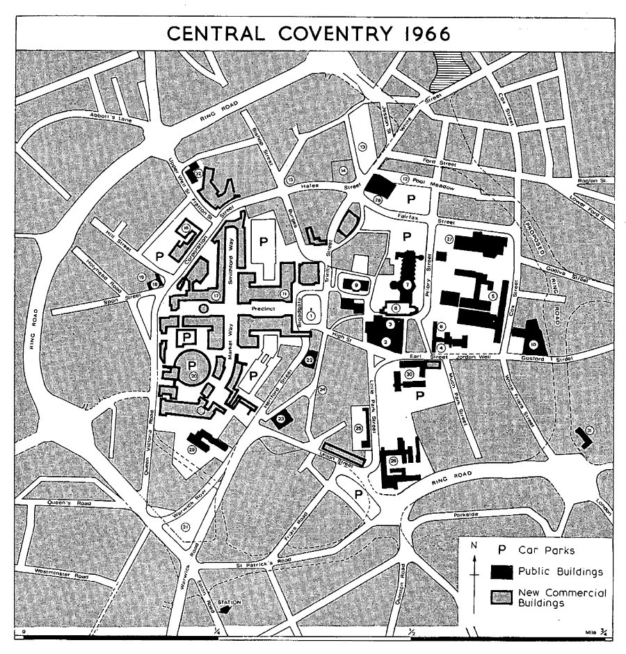
Central Coventry 1966
1. Lady Godiva Statue. 2. Council House. 3. St. Mary's Hall. 4. Herbert Art Gallery and Museum. 5. Lanchester College of Technology. 6. Cathedral Ruins. 7. New Cathedral. 8. Central Library. 9. Holy Trinity Church. 10. College of Art. 11. Hotel Leofric. 12. Central Bus Station. 13. Lady Herbert's Garden and City Wall. 14. Coventry Theatre. 15. Old Grammar School. 16. Belgrade Theatre. 17. Locarno Dance Hall. 18. St. John's Church. 19. Bond's Hospital and Old Bablake School. 20. Retail Market. 21. Greyfriars Green. 22. General Post Office. 23. Methodist Central Hall. 24. Ford's Hospital. 25. Telephone Exchange. 26. Police Headquarters. 27. Central Swimming Baths. 28. Fire Station. 29. Sibree Hall. 30. Council Offices. 31. Whitefriars. 32. Salvation Army Citadel. The exact course of the uncompleted section of the Ring Road was still under consideration in 1967.
To the south and east of the new cathedral are zones devoted to public and administrative buildings. Several are sited in a much-widened Little Park Street which, in 1965, was in process of conversion into what has been called 'a great outdoor room', to be known as Unity Way. Immediately east of the cathedral the area bounded by Priory Street, Ford Street, Cox Street, and Jordan Well has been completely re-planned and several intermediate streets have been abolished. This is also to be used for large public buildings which are intended to have a setting of planted open space, much of it closed to traffic. Incorporated in the lay-out is the 18th-century extension to St. Michael's churchyard with its old gravestones and established trees. Further north a reconstructed bus station is planned for the Pool Meadow site.
Hales Street and Corporation Street, which contain Coventry's two theatres, have been retained as an internal traffic route. Between this and the Inner Ring Road to the north a district is zoned for light industry. To the south of Broadgate the plan is still fluid, but it is probable that some residential development will take place in this area. Beyond the southern stretch of the Inner Ring Road the square in front of the rebuilt railway station forms a subsidiary business centre containing a fifteen-story block of offices.
On the outskirts of the city most of the large factories dating from the inter-war period have increased in size, while in addition several new industrial estates have been created, each accommodating a number of smaller firms. Four of these estates lie to the west of Coventry, but there is one at Caludon in the east and one at Rowley's Green in the extreme north. At Binley, where Binley Colliery was closed in 1963, an industrial estate has been established in Brandon Road. (fn. 233)
Nearly all the building connected with the corporation's vast post-war housing programme has taken place in the outlying areas, where a considerable amount of open land was available within the city boundary. (fn. 234) Over twenty estates have been or are being built on 'mixed development' lines, each incorporating blocks of flats and maisonettes as well as family houses and bungalows. The three largest estates, Tile Hill in the west, Willenhall in the south-east, and Bell Green in the former parish of Foleshill, are laid out as largely self-contained units, with churches, schools, shopping centres, and recreational facilities of their own. Tile Hill, occupying a site three miles from the city centre and formerly in Stoneleigh parish, was the first to be built. It contains over 2,500 dwellings and its nucleus is marked by three eleven-story blocks of flats and a church designed by Sir Basil Spence. The area served by the new shopping centre includes the pre-war residential development immediately east of Tile Hill. Further south the corporation had started a housing scheme at Canley before the Second World War. This has been completed and building has spread for nearly a mile along Charter Avenue to the west and as far as Canley Cemetery to the south-east. Other important corporation estates are those at Whitmore Park, at Manor Farm, Wyken, at Stoke Aldermoor, at St. Austell Road, Caludon, at Ernesford Grange, Binley, at Howes Lane, Stivichall, and at Stivichall Grange. A large new estate is also planned to the west of Kenilworth Road near Gibbet Hill. By 1965 the total number of dwellings built by the corporation since the Second World War was over 16,000. (fn. 235) After the abolition of building licences in 1954 many estates were developed by private enterprise. By 1958 the annual output of such dwellings began to overtake that of corporation dwellings and this trend has continued. Large private estates include those at Allesley, Eastern Green, and Mount Nod in the west, at Potter's Green, Walsgrave-on-Sowe, and Binley in the east, and at Stivichall in the south.
Between the newer development in the outlying areas and the Inner Ring Road lies a zone of mixed 19th-century residential and industrial property, much of it due for renewal. Mr. A. Ling, Coventry's second city architect, reported in 1959 that only 178 new dwellings had then been erected in these districts and that it was 'quicker, simpler and cheaper to build new neighbourhoods on virgin soil on the outskirts of the city than to tackle immediately the slums and older areas round the central core'. (fn. 236) In the Development Plan of 1951, however, two such districts, Hillfields and Spon End, had been designated as 'comprehensive redevelopment areas' with powers of compulsory purchase by the corporation. (fn. 237) At Hillfields, where streets of weavers' houses marked the beginning of Coventry's expansion between 1830 and 1860, it is proposed to house a population of over 6,000 at the high density of 116 persons to the acre. Flats will therefore provide 70 per cent of all new dwellings. By 1965 three ten-story blocks had been completed, one seventeen-story block was under construction, and a 30-story block beside Swanswell Pool was contemplated. Covered pedestrian ways, threading between the blocks at various levels, are planned, as well as a shopping precinct and pedestrian access to the city centre; there will also be some small 'corner' type shops. Some of the existing factories are to be retained while others will be re-sited. The Spon End redevelopment area covers the district between Holyhead Road and the Butts, including much of Spon Street itself. The plan provides for mixed residential development, and here, as at Hillfields, there will be space for one car for every dwelling. Pedestrian access to the city centre is planned to follow the banks of the River Sherbourne and it is intended that similar walks along strips of parkland will divide or connect the neighbourhood units of the future. In addition to these schemes for high density housing, it is hoped to bring new life to the city centre itself by providing more flats, both in separate blocks and on the upper floors of commercial buildings.
Two important developments have taken place on the extreme outskirts of Coventry in recent years. In 1964 the new University of Warwick was opened on a site near the city boundary to the west of Kenilworth Road. (fn. 238) Beyond the boundary to the east of the city the house and grounds of Combe Abbey, including the large lake known as Combe Pool, have been acquired by the corporation for conversion into a recreational centre for the inhabitants of Coventry. (fn. 239)
THE CASTLE.
A castle existed in Coventry by the mid 12th century and probably earlier. In 1147, when Ranulf (II), Earl of Chester (d. 1153), beseiged Coventry the king's men withdrew to the castle, but after Stephen relieved the town and routed the earl he is said to have destroyed the building. (fn. 240) It must, however, have been repaired for in 1182 Henry II confirmed a charter of Ranulf granted c. 1150 in which it was provided that the burgesses should have their own portmote and should not be called to the earl's castle for any pleas. (fn. 241) This provision was repeated in the charter of Ranulf's grandson, Ranulf (III), granted between 1200 and 1208. (fn. 242) The castle is also mentioned in a charter granted between c. 1161 and 1175. (fn. 243)
All physical remains of the castle disappeared at an early date and there has been much speculation as to its actual shape and size. However, a reconstruction from deeds and surveys of the Red Ditch (an unexplained and unplotted earthwork, formerly thought to have been thrown up during the Civil War) shows a suggestive pattern which, when related to the line of Bayley Lane and Pepper Lane, forms the shape of the outer ditch of an almost square fortification. (fn. 244) The Red Ditch appears behind a house on the east side of Broadgate and near Pepper Lane and Derby Lane, runs southwards behind houses on the east side of Greyfriars Lane, turns eastwards behind houses on the south side of Earl Street and then northwards behind houses on the west side of Much Park Street opposite Bayley Lane. (fn. 245) There is, in addition, evidence for a system of fortification of the main entry on the north-west side. Thus in 1410-11 three cottages in Broadgate (the name of which derives from the gate of the castle), just north of a tenement on the Red Ditch, were described as lying between the street and a stone wall; (fn. 246) behind them and parallel to them was Derby Lane, formerly known as Tirrystonlayne. (fn. 247) In the 13th century there were at least two holdings on the north side of Earl Street with land stretching northwards from the street to le Casteldich; (fn. 248) in 1411, west of St. Mary's Hall in Bayley Lane, was a tenement described as le Castellachous cum communi furno; it had no frontage upon Bayley Lane, but lay between the street tenement and a tenement by the southern end of St. Mary's Hall. (fn. 249)
Earl Street, first mentioned in the late 12th century, (fn. 250) later ran right through the centre of the castle site on the east-west axis of the fortification. (fn. 251) Houses soon appeared in the street and, some time before 1250, the Earl of Chester moved his seat to Cheylesmore (see below), allowing the castle to decay, and to be let out into tenements. (fn. 252) The builders of the first St. Mary's Hall, between 1340 and 1342, utilised part of the castle site and apparently some worked stone from the decaying building. (fn. 253) The construction of town walls during the latter half of the 14th century obviated the need for internal fortifications and gradually the castle disappeared from sight and from memory. The Council House, St. Mary's Hall, and the Drapers' Hall occupy most of the northern part of the site.
CHEYLESMORE MANOR AND PARK.
So far no evidence has been found regarding the first building of a manor-house at Cheylesmore. The etymology of the name Cheylesmore is doubtful (fn. 254) and its earliest appearance can be traced with certainty only to 1250. The park, however, was in existence about a hundred years earlier. It may have formed part of Stivichall until, sometime between 1154 and 1157, Hugh (II), Earl of Chester, and his mother Maud granted their estate there to Bishop Walter Durdent with all the appurtenances of the vill (including the land of the park-keeper) except the park itself. (fn. 255) The park lay south of the town and may originally have extended north as far as the southern ditch of the castle. During the 12th century a street (later called Much Park Street) leading towards the park developed just east of the castle ditch; then, as the castle fortifications disappeared, Little Park Street grew up in the 13th century, and also Cow Lane and Dead Lane. (fn. 256) It was probably a portion of the park that was granted about 1230 to the newly-arrived community of Grey Friars by Earl Ranulf (III) (fn. 257) who was subsequently recorded among their founders and benefactors as 'lord of Cheylesmore'. (fn. 258) After his death without issue in 1232 his Coventry possessions passed to his nephew Hugh de Albany, and then, in 1243, to his niece Cecily, the wife of Roger de Montalt, the Earl of Chester's steward. (fn. 259) In 1250 Roger and Cecily, on the former's decision to go on crusade, granted the priory in fee 60 librates of land in the manor of Coventry, from which they excepted the capital messuage of Cheylesmore, the park of the vill, and various other lands, rents, and services. (fn. 260) Robert, son of Roger de Montalt, (fn. 261) was said c. 1275 to have died seized of the manor of Coventry, including the capital messuage of Cheylesmore, the park, and the mill. (fn. 262)
The manor-house and park remained in the hands of the de Montalt family until the end of 1329 when Robert, younger son of Robert de Montalt, (fn. 263) died without issue. (fn. 264) Under a settlement made in 13278 by royal licence, and confirmed by the gift of Robert de Morlee, de Montalt's kinsman and heir, (fn. 265) the manor of Cheylesmore with 98 6s. 8d. rent in Coventry and the service of the prior passed to Queen Isabel (d. 1358) for life with successive remainders to the king's younger brother, John of Eltham (d. 1336), and the king and his heirs. (fn. 266) However, on the creation of the Dukedom of Cornwall in 1337 the reversion of the manor was among the possessions settled by the king on his eldest son (the Black Prince), as Duke of Cornwall and Earl of Chester, (fn. 267) to whom Queen Isabel subsequently made attornment. (fn. 268) Both the queen and the prince appear to have spent a considerable time at Cheylesmore and to have taken an interest in it, and it is said that the city's motto Camera Principis owes its origin to this close association. On the death of Queen Isabel the prince held his council in the hall of the manor-house. (fn. 269) In 1347 a plot of two acres in the park was granted for building an oratory in honour of the Virgin and a dwelling for a warden and twelve chaplains, who were to celebrate daily for the good estate of the king, Queen Isabel, and the Prince of Wales. (fn. 270) This building was never completed, (fn. 271) but at about the same time a large number of other plots was rented to merchants and others, (fn. 272) suggesting that there were frequent changes in the character of the park. When the city walls were built during the second half of the 14th century it seems that the northern boundary of the park was used for the line of the south wall of the city, (fn. 273) but the petition of the mayor and bailiffs in 1385 for a licence to complete the walls was granted on condition that they enclosed the site of the king's manor of Cheylesmore within the walls. (fn. 274) Thus the manor-house and its immediate precincts lay within the south-western angle of the wall and the park skirted its southern boundary. Poole states that the park was divided in 1388 into the Great Park and the Little Park, (fn. 275) but the occurrence of the names 'Littleparkstreth' and vicus parvi parci in the 13th century (fn. 276) suggests that the division may have taken place considerably earlier. According to a mid-17-thcentury survey the Great Park then contained 480 acres. It extended southwards from the city wall for about a mile to the boundary with Stivichall and was roughly half a mile wide from the road to Warwick on the west to a road leading to Whitley Common and the common itself on the east. The Little Park (25 a.) lay by the city wall in the north of the Great Park, from which it was separated by a rail, and was bounded on the east by a lane from Coventry to Park Mill. (fn. 277) The park was an asset to its owners for it provided timber, (fn. 278) stone, (fn. 279) water, (fn. 280) fish, (fn. 281) and venison (fn. 282) and other game. (fn. 283)
In 1549 the manor and park were granted by Edward VI to John Dudley, Earl of Warwick, and Jane his wife, (fn. 284) who leased it to the mayor and bailiffs for 99 years at an annual rent of 9 on condition that they allowed pasturage in the park to the poor of the city. When he was created Duke of Northumberland in 1551 John Dudley was succeeded as Earl of Warwick by his son John who granted the annual rent to his wife Anne for life. On the attainder of father and son in 1553 all their property was confiscated by the Crown. In 1568 Robert, Earl of Leicester, a younger son of the Duke of Northumberland, persuaded the queen to confirm the claim of Anne, Countess of Warwick, to the annual rent, and to grant the reversion of the manor and park of Cheylesmore 'now disparked' in fee farm to the mayor and bailiffs. (fn. 285)
In 1609 Henry, later Prince of Wales, successfully claimed the manor on the grounds that it was parcel of the inalienable Duchy of Cornwall, (fn. 286) but in 1620, on the petition of the mayor and bailiffs, Prince Charles granted them a lease of the manor and park for 21 years. A second lease was granted in 1628 which was to run for eighteen years from 1641. (fn. 287) The mayor and bailiffs were apparently allowed to enjoy the property during the Interregnum until the Crown lease expired in 1659. The manor and park, as Commonwealth property, were surveyed in the summer of that year under the Act for the sale of Crown lands. (fn. 288) It is not clear what happened to the property between 1659 and 1661. There is no evidence that it was sold or freshly leased by the Commonwealth to the mayor and bailiffs during the remaining months of the Interregnum. After the Restoration they petitioned the king for a renewal of the Crown lease of the manor-house and park, claiming that the latter was used as pasture for cattle by 'nearly 1,000 poor families in the town'. (fn. 289) Failing to obtain a lease, however, the mayor and bailiffs or at any rate the commoners had apparently resumed physical possession when, in 1661, the manor and the Great Park were leased by Charles II to Sir Robert Townsend, an influential Royalist, on condition that he should recover them for the Crown. Shortly afterwards Townsend obtained a verdict in ejectment against the mayor and bailiffs (fn. 290) and consequently also denied the citizens the right to pasture in the park. Fresh leases of the manor and park were granted to him in 1670 and 1676 and, after his death in 1685, to his son Anthony in 1686. (fn. 291) The mayor and bailiffs, however, maintained their legal claim to the property (fn. 292) and, though they did not succeed in getting the verdict reversed, their persistence and popular agitation in Coventry seem to have forced the Townsends to allow pasturage from time to time after 1666 in both the Great Park and the Little Park. (fn. 293) Finally, in 1705, Anthony Townsend assigned his lease of the Great Park to the mayor and bailiffs, (fn. 294) and in the following year they purchased the house and grounds from William Brown and Lady Townsend. (fn. 295)
By the end of the 17th century the park had become a place of fashionable resort. Most of its trees had gone but it boasted a fine avenue of ash trees (fn. 296) which extended from the Little Park Gate nearly to Quinton. (fn. 297) Freemen continued to be allowed to pasture their cattle in the park (fn. 298) and in 1705, when part of it was used for horse-racing, refreshment booths were set up. (fn. 299) In 1787 the avenue of trees was felled and in 1795 the process of dividing the park into gardens and inclosed fields was begun. (fn. 300) In 1819 the Prince Regent sold the park to Francis Seymour-Conway, 2nd Marquess of Hertford, who had leased it from 1787, and inclosure for private use was completed. (fn. 301) By 1837 a row of weavers' houses had been put up beside the manor-house, (fn. 302) and by the 1860s the Quadrant had been built on the area known as the Sheriff's Orchard, which had previously been a nursery garden. (fn. 303) In 1871 H. W. Eaton (who was created Lord Cheylesmore in 1887) (fn. 304) purchased the Coventry Park Estate from the 5th Marquess of Hertford, later giving from it the site of St. Michael's Vicarage and land for a new road from Greyfriars Green to Coventry station. The railway was cut through the northern part of the park in 1838, (fn. 305) but the whole area was not built over until the 20th century, when many new streets were developed and the extensive factories of the Armstrong Siddeley Motor Works, the Maudslay Motor Works, the Parkside Works, and the Quinton Works were built. Much of the rest of the park is occupied by the modern Cheylesmore Estate which was developed by a private company (London and Home Counties Property Investments Ltd.) in the late 1930s, the land having been bought from the 4th Lord Cheylesmore in 1934. (fn. 306)
The manor-house at Cheylesmore is known to have been in existence by 1250, but the period of its greatest importance was during the middle years of the 14th century, when Queen Isabel and the Black Prince were often in residence there. (fn. 307) It is probable that at that time, before the city walls were built, the house and its immediate environs were enclosed by a moat, some remains of which appear to have survived until the early 16th century. (fn. 308) In 1421 the capital messuage was beginning to decay and was repaired with timber from the park. (fn. 309) Further deterioration had taken place by 15389, when the commissioners' report on the adjacent Greyfriars property mentioned 'an old manor of the king's called Chyldesmore', and added that the hall was down, but that the lodgings might be repaired with tiles from the friary. (fn. 310) At the same period Leland described Cheylesmore as 'a palace . . . now somewhat in ruin'. (fn. 311) In 1659 the property still included outbuildings, orchards, and gardens, covering about three acres, but the capital messuage was 'much ruinated' and there were 'about ten bays of old decayed building'. (fn. 312) Sir Robert Townsend, who leased Cheylesmore in 1661 and died there in 1685, is said to have laid out much money in repairing the mansion. (fn. 313) After it was acquired by the city in 1706, the house does not appear to have remained long in single occupation. In 1738 a weaver was proposing to make a tenement of what was then called the great hall. (fn. 314) A hundred years later all the remaining buildings had either been divided into tenements or replaced by new weavers' houses. At the end of the Second World War two ranges of largely timber-framed buildings survived, one of them incorporating a gatehouse. At least some of these buildings, which were of various dates, must have represented the 'lodgings' which were thought worthy of repair in 15389.
Any reconstruction of the medieval lay-out can only be conjectural, but it is probable that the surviving ranges formed the south and east sides of a large irregular courtyard. The gatehouse is in the centre of the east range and the original great hall, which was said to be 'down' in the early 16th century, may have stood opposite to it along the west side of the court. (fn. 315) In 1955 a building which had formed the west end of the south range was demolished.
This was a two-storied structure of six bays, encased with later brickwork. The character of its roof, which had crown-posts supporting a collar-purlin with scissor-bracing above, suggests that it was built in the 14th century. One crown-post with stopchamfered four-way struts and a moulded base and cap was particularly notable. Alterations to the building, including a stone chimney at its west end, had been made in the 17th and 18th centuries, some of them probably by Sir Robert Townsend; at a later date weavers' windows were inserted. (fn. 316) It has been suggested that this structure represented a solar wing, containing on its upper floor the more important living apartments of the manor-house, and that it was built in the 14th century at the south end of the great hall. (fn. 317) The surviving remnant of the south range now forms the southern cross-wing of the gatehouse block. It has been partly faced with brickwork but consists of two distinct timber-framed structures, both of medieval date. (fn. 318) One is singlebayed and has a roof similar to that of the demolished building, although on a much smaller scale. The other roof is of the purlin type with an open archbraced collar-beam truss dividing its two bays. Between the two sections of the wing is a masonry wall, now serving as the base of a chimney, but perhaps originally part of an even earlier building. The gatehouse itself has walls of close-studded timber-framing and appears to have been built or rebuilt in its entirety in the 16th century. It is of three bays, with a carriage-way occupying the central bay on the ground floor. The original timbering and a Tudor doorway are visible on the north side of the carriage-way. An unusual structural feature is the use of stone filling in the panels between the vertical studs of the framing. The northern cross-wing of the gatehouse range is a complex structure with at least part of its ground floor incorporating an early stone building. One internal wall, 2 ft. 6 in. thick, contains a massive stone arch with an ogee head, almost certainly of 14th-century date. The upper story is timber-framed and is thought to have been added in the 15th century. Adjoining the north wing is a three-storied block of weavers' dwellings. Although apparently brick-built and dating from c. 1800, this block has traces of both masonry and timbering in its walls. In the 19th century the exposed framing in the gatehouse range was plastered externally (fn. 319) and all the windows appear to have been replaced.
CITY WALLS AND GATES. (fn. 320)
Coventry did not become a walled city until the second half of the 14th century but there were ditches surrounding the town, and bars at the main exits certainly in the 13th and most likely late in the 12th century. The bars were probably in the nature of obstacles across the streets and did not necessarily mark boundaries, since one way out of the town might have two bars at some distance from each other. On the west there were bars in Smithford Street, inside the later walls, and probably above the bridge; there were also bars in Spon Street, west of the site of the later Spon Gate, probably at the end of Barras Lane and with ten or more tenements between the bars and the later gate. (fn. 321) In Well Street the bars, which existed late in the 12th century, (fn. 322) were closer to the gate, about two tenements outside it. (fn. 323) Near Hill Street and Hill Mill was the Red Dyke, (fn. 324) perhaps connected with Spon bars and St. Nicholas bars. The bars at the top of Bishop Street existed in the 13th century (fn. 325) and occupied the same site as Bishop Gate; (fn. 326) a second bar stood further north in St. Nicholas Street near the church. (fn. 327) Cook Street bars stood outside the later gate. (fn. 328) On the east side of the town there were two bars, one in Earl Street at the end of Earl's Mill Lane (fn. 329) and a second beyond Gosford Gate and the bridges. (fn. 330) On the south there were bars in Much Park Street and Little Park Street; (fn. 331) these cannot be located, but they probably stood just above the entrances to the park. As yet only some sections of the ditch can be roughly plotted. It ran south of Smithford Street, (fn. 332) probably curving north to Spon Street bars, continuing north and east to Barrs Hill and the bars near St. Nicholas's Church. There is, however, archaeological evidence for the existence of a ditch, 20 ft. wide and 9 ft. deep, just north-east of Well Street Gate, which could represent an inner fortification. (fn. 333) In the absence of any evidence for a ditch on the north and east sides, it may be doubted whether one existed, for the town was flanked on these sides by the priory and its manor of Harnall. Probably the Hyrsumditch, which lay south of Gosford Street, (fn. 334) had some connection with the Earl's Mill Lane bars. On the south side no ditch can be traced, almost certainly because on this side the town was flanked by Cheylesmore Park.
Although in 1329 a licence was granted to the priory and men of Coventry to levy murage for building a wall round the city, (fn. 335) work does not seem to have started for some time. Eight available versions of the city annals (fn. 336) agree that building began during the mayoralty of Richard de Stoke, who was mayor in 1352, 1355, 1357, 1361, and 1367. (fn. 337) They state that Richard laid the first stone of New Gate (according to tradition during his mayoralty of 1355), that work began on the wall at this point, and that it was not completed for 41 years. It was not until 1363 that licence to crenellate was granted (fn. 338) and this was followed 22 years later by a licence to complete the work. (fn. 339)
While the walls and gates were being erected much damage was done to both houses and gardens for, although the ancient ditches were used as much as possible, there were large areas where new ditches had to be constructed. On the north-west side a new ditch was dug, a gate was built south-east of the Well Street bars, and three cottages and their gardens were destroyed in the process. (fn. 340) East of Bishop Gate several gardens were cut by the new ditch. (fn. 341) In Cook Street six cottages lay together along its northern side; two were destroyed, three remained within the wall, and one was left outside the wall marking the site of the ancient bars; (fn. 342) on the south side of the street two gardens were largely destroyed and, as a consequence, the priory's pittancer received only half the previous rent. (fn. 343) Doubtless other properties, not belonging to the priory, suffered similar damage.
Twelve gates were erected at strategic points: (fn. 344) Spon or Bablake Gate (porta de Babylake) was built soon after 1391 with stone from Cheylesmore Park (fn. 345) and lay in Spon Street, then the main Holyhead road; Hill Street Gate was rebuilt in 1423; (fn. 346) Well Street Gate (porta in vico fontis) (fn. 347) is first noted in 1411; Bishop Street or Bishop Gate (porta episcopi), (fn. 348) on the main exit to the north and in existence by 1411, was rebuilt in 1689; (fn. 349) Cook Street Gate was probably known by this name in 141011; (fn. 350) Priory Gate, standing about 130 yds. south-east of Cook Street Gate, was called 'Priorie yate' in 1518 (fn. 351) and 17489, (fn. 352) but was also known from the 19th century as Swanswell Gate; (fn. 353) Derngate or Bastille (called le Dernzate in 1411 and 'the Derne yate called the Bastell' in 1480) (fn. 354) lay at the bottom of Earl's Mill Lane just south of the river; Gosford Gate (porta de Gosford) (fn. 355) lay on the main exit to the east and was in existence by 1411; New Gate, said to have been begun in 1355 and certainly by 1367, lay on the main road to London, at the bottom of Much Park Street; Little Park Gate, an entrance to the park from Little Park Street, is first referred to in 141011 as 'the gate'; (fn. 356) Park or Cheylesmore Gate was an entrance to the park from Greyfriars Lane by Cheylesmore manor-house, (fn. 357) which was enclosed by the wall after 1385; (fn. 358) Greyfriars Gate (called Frer Gate in 1421) (fn. 359) was licensed to be built with stone from Cheylesmore Park in 1385 (fn. 360) and was the main exit to Kenilworth and Warwick. In addition there were at least twenty intermediate towers, some of which contained small postern gates; more than half of these towers were built along the southern stretch of wall between Greyfriars Gate and Gosford Gate. (fn. 361)
The wall was built and kept in repair by means of murage levied on the merchants and inhabitants of the town; murage was first granted in 1329 (fn. 362) and was levied again, on the assessment of the mayor and bailiffs, in 1364. (fn. 363) In 1365 the levy was confined to laymen having rents and goods in the town. (fn. 364) Licence to collect murage was granted from time to time, (fn. 365) but collection was not without opposition, as, for example, from the victuallers in 1370 who claimed that they were impoverished by this imposition. (fn. 366) The farm from the sealing of woollen cloth was also granted towards the building of the walls. (fn. 367) The construction and upkeep of the walls were a serious drain on the treasury of the city, so much so that the mayor and commonalty obtained a licence in 1417 to acquire lands, rents, and services to the value of 40, within the town and its precincts, to help to defray their expenses. (fn. 368) About 1432 fines for misdemeanours ordered by the court leet were all being put towards expenditure on the walls. (fn. 369) The burden of the upkeep of the walls can be judged from an order of leet of 1473 that the chamberlains (who were responsible for this) were to spend 10 a year on the old wall between New Gate and Little Park Gate, (fn. 370) that is the portion of the wall first built. In 1480 Prior Deram complained of the encroachment of the city wall on priory land since 1403 (thus providing a date for the building of part of the north-east section of the wall); he also complained that, although he and his predecessors had voluntarily paid 10 a year murage for the construction of six perches of wall each year round the priory area, yet only two perches were built each year and the rest of the money was spent on other parts of the wall. (fn. 371) St. Osburg's Pool and the priory land north of the River Sherbourne had been included within the compass of the walls at the request of Prior Shotteswell in 1461 (fn. 372) and this portion of the walls was still being built in 1480. Stone for the walls and gates was taken from the actual site (thus helping to form the ditch), (fn. 373) from the quarry in Cheylesmore Park, (fn. 374) and from a quarry at Allesley. (fn. 375) By the beginning of the 17th century the walls were overgrown with ivy and in a state of decay, (fn. 376) but they were sufficiently restored for the defence of the city at the time of the Civil War. Indeed in 1642 Coventry was described as being walled as well as London; the circumference of the walls was nearly three miles and there were four strong gates, guarded night and day by four hundred armed men, and strong battlements with towers. (fn. 377)
Local tradition says that because the inhabitants made use of their walls to deny entrance to Charles I in 1642, Charles II in 1662 ordered that they be razed to the ground. A letter from Charles II in 1662 to the Earl of Northampton makes it clear, however, that the demolition was provoked by the harbouring of rebels in this stronghold after the Restoration. (fn. 378) A council minute of 27 August 1662 records the destruction of the walls by the Earl of Northampton by order of the king and a resolution that anyone taking away stone was to pay 1s. a load. (fn. 379) By 1672 the matter had ceased to be urgent and an effort was made to preserve what remained of the walls; proceedings were threatened against anyone found removing stone. (fn. 380) Two years later a leet order confirmed this prohibition, (fn. 381) while from 1686 the council appointed members to inspect the remains of the walls and gates and attempts were made to keep them in repair. (fn. 382) The need for extra houses led to the use of the gates for habitation; Bastille Gate was occupied c. 1675, (fn. 383) New Gate in 1681, (fn. 384) Bishop Gate in 1691; (fn. 385) in 1705 the towers were viewed so that they might be let for habitation of tenants; (fn. 386) in the same year Greyfriars Gate was occupied. (fn. 387) Bradford's survey of 17489 shows the twelve gates and what remained of the walls at that date. New Gate was removed in 1762; (fn. 388) it appears to have been a tall rectangular structure surmounted in Bradford's time by a single turret or cupola and at a later date by twin gables. (fn. 389) Most of the other gates had gone before the end of the 18th century, but Bastille Gate survived until 1849. (fn. 390) In 1870 only two were left Cook Street Gate and Swanswell Gate (fn. 391) and these are still standing. Drawings exist of some of the principal gates, presumably made before their demolition. (fn. 392) Gosford Gate, removed in 1765, (fn. 393) was of two stories with its upper floor lit by pointed windows of one and two lights. There were two circular turrets at parapet level on its outer wall and the former chapel of St. George was attached to its north-east corner. (fn. 394) Spon Gate was a massive structure, flanked externally by two embattled polygonal towers. On its inner face the lower story reached nearly as far as the west wall of St. John's Church. The gate was demolished in 1771 and some of the stone is said to have been used for the building of Spon Bridge. (fn. 395) Greyfriars Gate, taken down in 1781, had flanking circular towers with conical roofs. (fn. 396) The two lower stories formed an embattled projection into Warwick Lane, the gateway arch being surmounted by pointed two-light windows alternating with pinnacled niches. Bishop Street Gate (demolished in 1765), (fn. 397) Well Street Gate, and Hill Street Gate appear to have been rectangular two-storied buildings with embattled parapets. (fn. 398) Bastille Gate was a similar structure but an extra story had been added when it was converted into a dwelling house. The two surviving gates are also examples of the lesser city gates of this type. Cook Street Gate is approximately square in plan, projecting externally beyond the line of the walls. The room above the gateway has a two-light squareheaded window facing Cook Street and lateral doorways communicating with the top of the walls. Grooves for a portcullis are visible in the jambs of the outer arch. The gate was presented to the city by Col. Wyley in 1913 and restored in 1918. (fn. 399) The stone vault above the gateway is missing and the parapets have been renewed. Swanswell Gate was originally a similar structure, but the archways were blocked, windows were inserted, and the roof was raised when it became a cottage in the mid 19th century. It was being used as a shop until shortly before its acquisition by the city from Sir Alfred Herbert in 1931; it was altered and restored in 19312. (fn. 400) In the small park known as Lady Herbert's Garden between the two surviving gates much of the city wall is standing, although not to its full height. In places its construction, consisting of two outer skins of ashlar masonry with a rubble core, is clearly visible. No other substantial remains of the wall survived in 1966, but much of its line could be traced on large-scale maps of the city, following the boundaries of gardens and other properties. (fn. 401)