A History of the County of York East Riding: Volume 7, Holderness Wapentake, Middle and North Divisions. Originally published by Victoria County History, London, 2002.
This free content was digitised by double rekeying. All rights reserved.
K J Allison, A P Baggs, T N Cooper, C Davidson-Cragoe, J Walker, 'Middle division: Burton Constable', in A History of the County of York East Riding: Volume 7, Holderness Wapentake, Middle and North Divisions, ed. G H R Kent (London, 2002), British History Online https://www.british-history.ac.uk/vch/yorks/east/vol7/pp129-137 [accessed 2 May 2025].
K J Allison, A P Baggs, T N Cooper, C Davidson-Cragoe, J Walker, 'Middle division: Burton Constable', in A History of the County of York East Riding: Volume 7, Holderness Wapentake, Middle and North Divisions. Edited by G H R Kent (London, 2002), British History Online, accessed May 2, 2025, https://www.british-history.ac.uk/vch/yorks/east/vol7/pp129-137.
K J Allison, A P Baggs, T N Cooper, C Davidson-Cragoe, J Walker. "Middle division: Burton Constable". A History of the County of York East Riding: Volume 7, Holderness Wapentake, Middle and North Divisions. Ed. G H R Kent (London, 2002), British History Online. Web. 2 May 2025. https://www.british-history.ac.uk/vch/yorks/east/vol7/pp129-137.
In this section
BURTON CONSTABLE
Burton Constable, seat of the Constable family, lords of Holderness since the 16th century, (fn. 1) lies over 5 km. ENE. of Swine village and c. 7 km. south-west from the coast at Aldbrough. Apart from the Hall (fn. 2) and its outbuildings, there are only a few scattered houses. The common, Anglian name Burton, meaning settlement, was qualified in 1086 with the prefix 'Santri', the significance of which is unknown; in 1190 the name of its previous tenant, Erneburga, was used to differentiate it and from the mid 13th century that of her descendants, the Constables. (fn. 3) Burton Constable, containing 1,277 a. (517 ha.), (fn. 4) was combined with West Newton hamlet, in Aldbrough parish, as West Newton township, which had 2,068 a. (837 ha.). (fn. 5) In 1935 West Newton with Burton Constable civil parish, formerly West Newton township, and that of Marton were united as Burton Constable civil parish. The combined area, of 3,015 a. (1,220 ha.), (fn. 6) was reduced slightly by a transfer to Ellerby in 1952. (fn. 7) In 1984 some 10 ha. (25 a.) more were transferred to Ellerby, and in 1991 Burton Constable's area was 1,205 ha. (2,978 a.). (fn. 8) In 1377 Burton Constable and West Newton together had 105 poll-tax payers, (fn. 9) and 16 houses there were assessed for hearth tax in 1672. (fn. 10) The two hamlets had 172 inhabitants in 1801, 239 in 1851, but only 147 in 1901 and 141 in 1931. Burton Constable itself contributed 124 to the 1851 total, that number including the family and their visitors at the Hall and the staff of c. 40. (fn. 11) The combined population of the civil parishes united in 1935 had been 214 in 1931. The new civil parish evidently had 263 inhabitants in 1951, before the loss of c. 40 people to Ellerby in 1952. Thereafter the population declined, from 200 in 1961 to 128 in 1981, but it had recovered by 1991, when there were usually 159 residents and 165 were enumerated. (fn. 12)
BURTON CONSTABLE hamlet. By the later 18th century there were, apart from the Hall, only half a dozen scattered houses in the township. They included Smithy Briggs Farm, since rebuilt, the later Brickyard House, and a keeper's lodge in Norwood. Another house standing close to the western boundary and near the way to Thirtleby was then called Burton lodge; it had been demolished by the mid 19th century, possibly being replaced by Lodge Farm, which had by then been built across the boundary in Ellerby. (fn. 13)
MANOR AND OTHER ESTATES
In 1086 the archbishop of York had 5 carucates at 'Santriburtone', later BURTON CONSTABLE, and 3 carucates in the adjoining West Newton. (fn. 14) Later the counts of Aumale held 6 carucates in both places as military tenants of the archbishop until their holding passed to the Crown with the honor of Aumale by the death of Aveline de Forz, countess of Aumale, in 1274. (fn. 15) Burton Constable manor and its member at West Newton were held of the Crown as ¾ knight's fee in 1336, (fn. 16) and Burton Constable alone was reckoned 1/3 knight's fee in the 16th century. (fn. 17)
A knight occupying land at 'Santriburtone' in 1086 (fn. 18) was evidently succeeded by Erneburga of Burton, who married the count of Aumale's constable Ulbert (fl. earlier 12th century). Her son Robert Constable had land at 'Erneburgh Burton' before 1190, (fn. 19) and in the 13th century the Constable family was recorded as holding all 6 carucates of the count of Aumale's estate, (fn. 20) comprising 3 carucates in each of the two settlements, (fn. 21) then called Burton Constable and Newton Constable. (fn. 22) In 1231 William Constable and William de Forz, count of Aumale, were in dispute about hunting over the estate. (fn. 23) Robert Constable was named as lord of Burton Constable in 1316, (fn. 24) and at his death by 1336 the demesne there and at West Newton comprised 1 carucate and almost 100 a.; 3 carucates and 1 bovate and other land were then held by bond tenants, cottars, and a free tenant. (fn. 25) Robert's son John Constable (d. 1349) bought 1 carucate and rent at Burton Constable, (fn. 26) and more land there had been purchased by the mid 15th century. (fn. 27) By the 16th century the estate evidently also included land held of the archbishop. (fn. 28) The manor continued to descend, with Halsham, in the Constables, viscounts Dunbar in the 17th and early 18th century, and their heirs, the Tunstalls, Sheldons, Cliffords, and Chichesters, all of whom substituted or added the name Con stable. (fn. 29) In 1827 the whole of Burton Constable hamlet was occupied by Sir Thomas Constable, Bt., and his tenants. (fn. 30) In 1992 the ChichesterConstable family, in association with the National Heritage Memorial Fund and Leeds City Council, set up the Burton Constable Foundation, and endowed it with the Hall, stable block, and other outbuildings, and 320 a. of parkland. The rest of the Burton Constable estate in Burton Constable and neighbouring villages belonged to Mr. John ChichesterConstable, who had c. 688 ha. (1,700 a.) in 1995, and his daughter, Rodrica Straker, who then owned 485. 6 ha. (1,200 a.). (fn. 31)

Burton Constable Hall, Block Plan.
The chief house at Burton Constable, mentioned from 1294, (fn. 32) succeeded Halsham as the family's main residence, apparently in the late 15th century. (fn. 33) The site may have been moated, a curving ditch running around the north and east of the house until its reduction in the mid 18th century to a fishpond, which remained in 1995. (fn. 34) The early structural history of the house is obscure. A length of ashlar wall at the centre of the north elevation forms one side of a nearlysquare room, which was later heightened in brick to become a tower. It has a turret staircase at its south-west corner, and both tower and turret have a possibly 15th-century, brick corbel table below the parapet. The two-storeyed range which abuts the tower on the east appears to be structurally contemporary; that to the south is late 16th-century but replaces an older building from which a disused fireplace survives on the south face of the tower. Those northern and western ranges, together with a southern one, formed a three-sided, courtyard house which was probably still being built in 1578 (fn. 35) but seems to have been substantially complete by the end of the century. Its principal elevations looked inwards towards the court, which was closed on the east by a wall with a turreted gatehouse. (fn. 36) By the early 17th century that was an old-fashioned plan, and a new range was begun along the west side of the house to screen the back of the main range and provide an up-to-date elevation towards the park. It was to be linked to the old building by short ranges separated by one or more small, open courts. The new work, which evidently included a gallery, (fn. 37) was left unfinished, (fn. 38) perhaps because of the death of Sir Henry Constable in 1607. (fn. 39) It seems probable that at the same time as the new work was going on the old, main range was being remodelled, and the great hall and parts of the east front date from the late 16th or early 17th century. The two-storeyed hall occupied less than half the elevation, which was more than 130 ft. long. The great bay window was at the centre, on the axis of the gatehouse, and the entrance near the south end, through a relatively modest, Classical doorway with strapwork ornament. (fn. 40) Within there was a stone hall screen with similar strapwork ornament. (fn. 41) A tower matching the earlier one to the north occupied the corner between the main range and the south wing, which contained the kitchen and service rooms. With its red-brick "çades, prominent quoins, and large mullioned and transomed windows, some of them bayed, the house had much of its present appearance by the late 17th century. (fn. 42)
A few rooms have reset, early 17th-century panelling, but little structural work seems to have been carried out that century, and only in the early 18th was the gallery panelled. That work appears to have been part of a phase of improvement which included the refitting of the hall, the creation of a cabinet room on the ground floor of the north tower, and the panelling of some adjacent rooms. Externally, two new sash windows and a doorway, all with pediments, were made on the north front. A small addition on the south side of the south wing contains a ground-floor room with an elaborately-moulded cove and above it a room with panelling, overmantel, and rich plasterwork in the style of the 1740s; the rooms suggest the use of the east end of that wing as a self-contained suite - perhaps for the young William Constable or his sister Winefred, who lived at Burton Constable until her death in 1774. (fn. 43) When William inherited in 1747, he is said to have considered demolishing the house and rebuilding in a more fashionable style; (fn. 44) instead he remodelled it. Dated rainwater heads around the eastern court imply an extensive renovation between 1757 and 1760, and it may have been then that a parapet with windows was substituted for attic dormers on the hall range. Probably in the late 1750s, the large, central, hall bay was removed and replaced by a feature incorporating a doorway, (fn. 45) the whole being surmounted, a few years later, by an elaborately-carved achievement of the arms of William Constable, viscount Dunbar (d. 1718). (fn. 46) Inside, the hall was refitted in a partly Jacobean-revival style to designs by Timothy Lightoler of York (fn. 47) between 1765 and 1769. (fn. 48) Before his death in 1769, Lightoler also designed the dining room, the State Drawing Room, and the staircase hall. (fn. 49) In 1772-3 a new service court was formed against the south side of the house from designs by 'Capability' Brown. (fn. 50) The northern end of the west range had never been built, and it was not until c. 1770 that Constable completed that elevation; the major interior, now the ballroom, is of 1775 and by James Wyatt. Thomas Atkinson of York designed an adjacent room in 1774, formerly used for billiards but now the chapel, and in 1783 the Blue Drawing Room at the centre of the west front. (fn. 51)
Alterations in the 19th century were largely concerned with the remodelling and redecoration of the interior and its gradual elaboration with pictures and furniture by Sir Thomas Constable, Bt. (d. 1870), and his wives. The gallery was restored soon after 1830, (fn. 52) and it is now difficult to distinguish the plasterwork of the 17th century, the later 18th-century remodelling, and the 19th-century restoration. The Chinese Room, originally furnished by Thomas Chippendale in 1784, similarly had its decoration enhanced in the style of the Royal Pavilion c. 1840. (fn. 53) The billiard room was converted to a chapel with a semicircular sanctuary in 1830 and refitted in 1844, (fn. 54) and a theatre made from firstfloor rooms at the south end of the house was used in the 1840s and 1850s. (fn. 55) Outside, the sash windows which had been installed during the later 18th-century alterations to the west front were replaced by stone mullions and transoms. (fn. 56) The house was restored again c. 1910 and by John Chichester-Constable after 1963. (fn. 57)
Cuthbert and William Constable assembled an extensive library in the house which was used by, among others, George Poulson for his History and Antiquities of the Seigniory of Holderness; William was also a collector of scientific apparatus and exhibits, and a later owner, Sir Thomas Constable, Bt. (d. 1823), was an eminent topographer and botanist. By 1994 most of the remaining collections had been given to Leeds City Art Galleries, which were responsible for their preservation and display in the house. (fn. 58)
(Sir) Simon Constable was granted free warren at Burton Constable and West Newton in 1285, and Burton Constable park was recorded from 1367. (fn. 59) The medieval park lay to the west of the house, on the boundary with Ellerby, where a 36-a. close was later called Old park. (fn. 60) Surviving ridge and furrow testify to the enlargement of the park at the expense of the tillage, and in the 1570s and 1580s Sir John Constable and his son (Sir) Henry also added parts of a pasture in Sproatley. (fn. 61) In 1578 there was 385 a. of parkland stocked with red and fallow deer. (fn. 62) That park is presumably to be identified with six closes totalling c. 380 a. in 1621. The enlargement of the park brought it closer to the house across a shallow, north-south valley, which by 1621 had been dammed to form ponds, the southernmost of which was a long rectangle enclosing a narrow island. Around the house were brick-walled courts, bounded on the north and east by the irregular ditch. (fn. 63) The eastern court was entered through a turreted gatehouse, and by the late 17th century there was a further court with ashlar gate piers. (fn. 64) About ½ km. south-east of the house, and outside the park, a late 16th-or early 17th-century, octagonal, brick tower may have combined a viewing point with a high-level water tank. (fn. 65)

Burton Constable 1621
Although the main approach to the house was through the eastern forecourts, it could also be reached by a tree-lined track from Thirtleby. Formal avenues leading south, east, and west from the house and north to Norwood had been made by the early 18th century, perhaps as part of a recent landscaping scheme, which also involved the creation of a water garden and a small formal garden, respectively north and west of the house. (fn. 66)
It was probably in the garden to the west of the house that William Constable with Thomas Knowlton and Thomas Kyle c. 1758 established a botanical garden with greenhouse and hot walls. (fn. 67) In 1763 Constable added at the northern end of the ponds a menagerie, comprising a walled enclosure with small pavilions or houses along its north side and in the southern corners. (fn. 68) The general landscaping of the grounds was apparently undertaken from the 1760s, following the commissioning of designs from 'Capability' Brown, Thomas White, and Constable's architect, Timothy Lightoler. (fn. 69) The plan adopted owed as much to White as to Brown, but it was the latter who superintended the work and visited Burton Constable until 1782. (fn. 70) Apart from the serpentizing of the ponds, the changes involved the enlargement of the grounds east and north of the house, the felling of the eastern avenue, and much planting of clumps and feature trees around the house. Closer to the house, the gatehouse, walls, and formal gardens were replaced by lawns protected by a ha-ha. In 1774 William Constable had 713 a. in hand, all or most of it occupied as grounds. The Hall and the land within the ha-ha comprised nearly 10 a.; the park, excluding the lakes, was of 152 a., and 148 a. more lay in adjacent closes later added to the park; the Lawn and Stable Lawn accounted for another 124 a., and two woods together had a similar acreage. There was simultaneously much building within the park, mostly designed by Lightoler. Extensive stables and farm buildings around yards had been built on the site of old farm buildings to the south-east of the house by 1768, and the former stables north-east of the house were demolished. (fn. 71) At about the same time, a new kitchen garden was built behind the menagerie replacing that then cleared away from the west of the house. (fn. 72) A bridge designed by Brown (fn. 73) was built to disguise the dam between the upper and lower lakes, which were being made in 1775, (fn. 74) and about that date a pavilion overlooking the upper lake was added in the menagerie enclosure. (fn. 75) The bridge became a feature of the southern drive to the house which was completed in 1778 (fn. 76) and c. 1785 given a Gothick gatehouse, designed by James Wyatt, at the entrance to the park from Sproatley. (fn. 77) To the south-west of the house, a 'dry house', or greenhouse, (fn. 78) which existed c. 1780, was refaced as an orangery in 1788-9 to designs by Thomas Atkinson. (fn. 79)
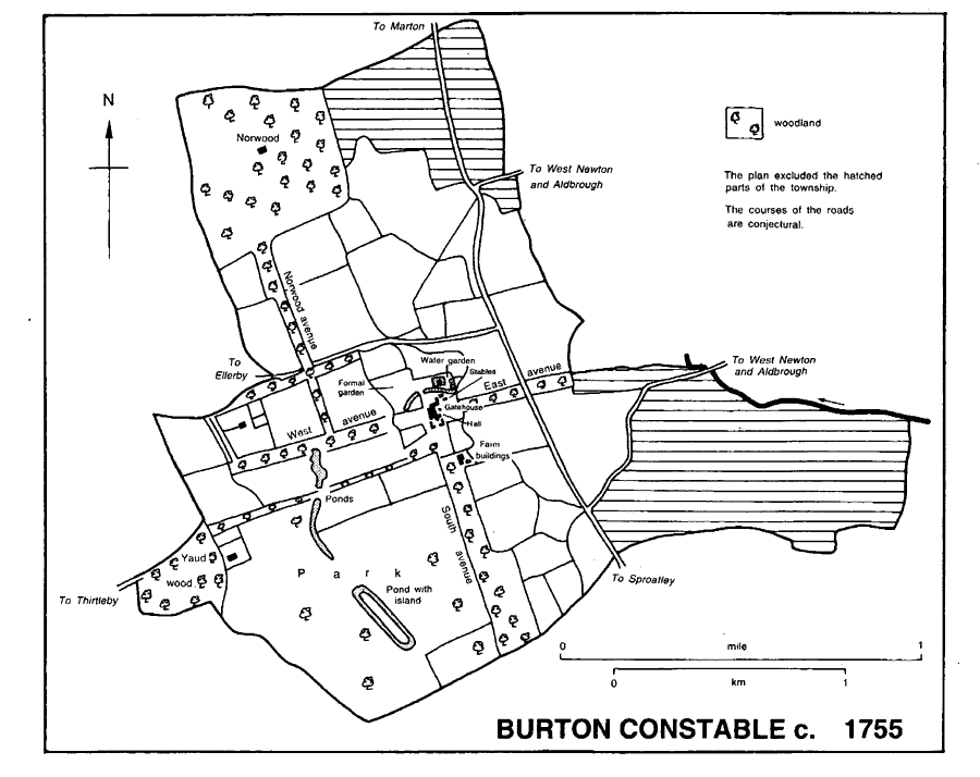
Burton Constable c. 1755
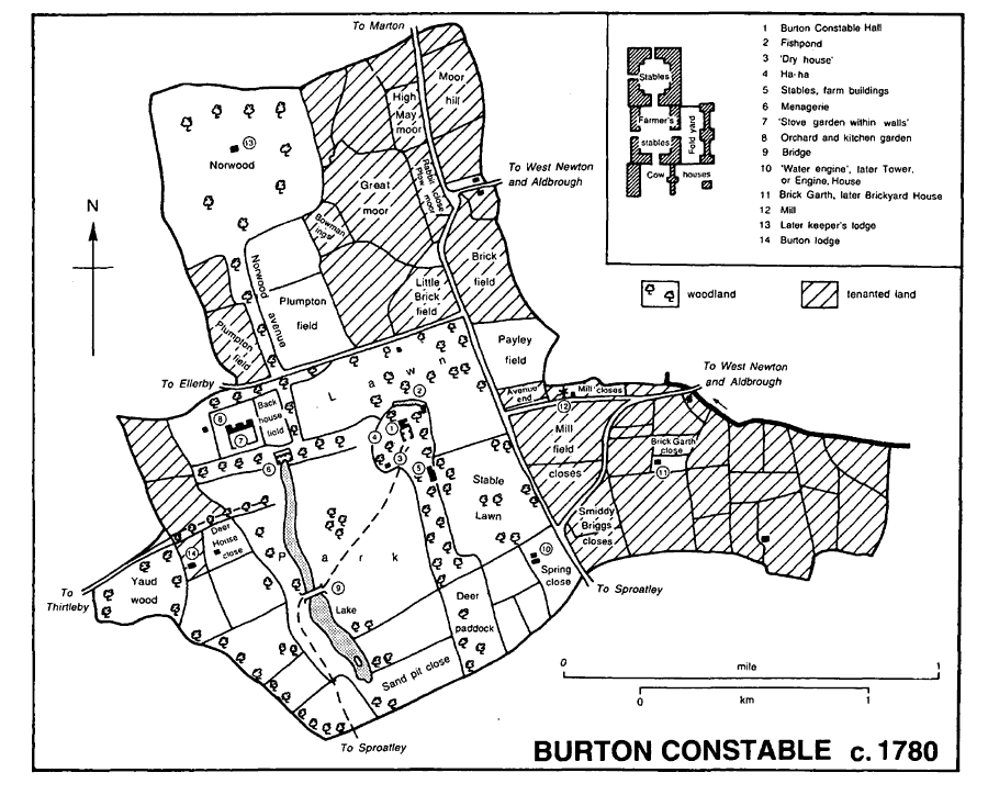
Burton Constable c. 1780
Norwood was felled at the end of the 18th century, and a private course for horse-racing and steeplechasing had been laid out there by 1838, when the Holderness Hunt meeting was transferred from Beverley to Burton Constable; the meeting remained there until c. 1850. (fn. 80) Early in the 19th century, the main farm buildings were converted into additional stables and others were replaced by a covered riding school. (fn. 81) The west lawn was then dug up to make formal gardens with topiary and artificial-stone statuary, and a large statue of a stag was placed at the end of a vista from the house c. 1860. (fn. 82) On the other side of the house, part of the old east avenue was planted with trees and the clumps on the Lawn were multiplied and enlarged, while to the north-west Norwood avenue was infilled as another plantation. (fn. 83) New buildings included a second lodge, later New Lodge, in a neo-Jacobean style by James Blake which was put up across the boundary in Sproatley in the 1860s. (fn. 84) Roughly contemporary were a neoTudor castellated house, called Tower, or Engine, House, which was built onto the early, octagonal tower south-east of the Hall, (fn. 85) and a gas works near the stables. (fn. 86) The deer herd, c. 600 strong in 1840, was given up, apparently in the late 19th century, and the deershed in the park was demolished. (fn. 87) A beagle pack was however maintained at Skirlaugh into the mid 20th century. (fn. 88) A large caravan park was created beside the lake in 1968, (fn. 89) and by 1995 a clubhouse had been built there. The grounds were then grazed by cattle, sheep, and horses associated with a riding school in the stables, but the walled kitchen garden was disused and many of its buildings had been demolished.
By 1190 Robert Constable had given Thornton abbey (Lincs.) a rent at Burton Constable. (fn. 90)
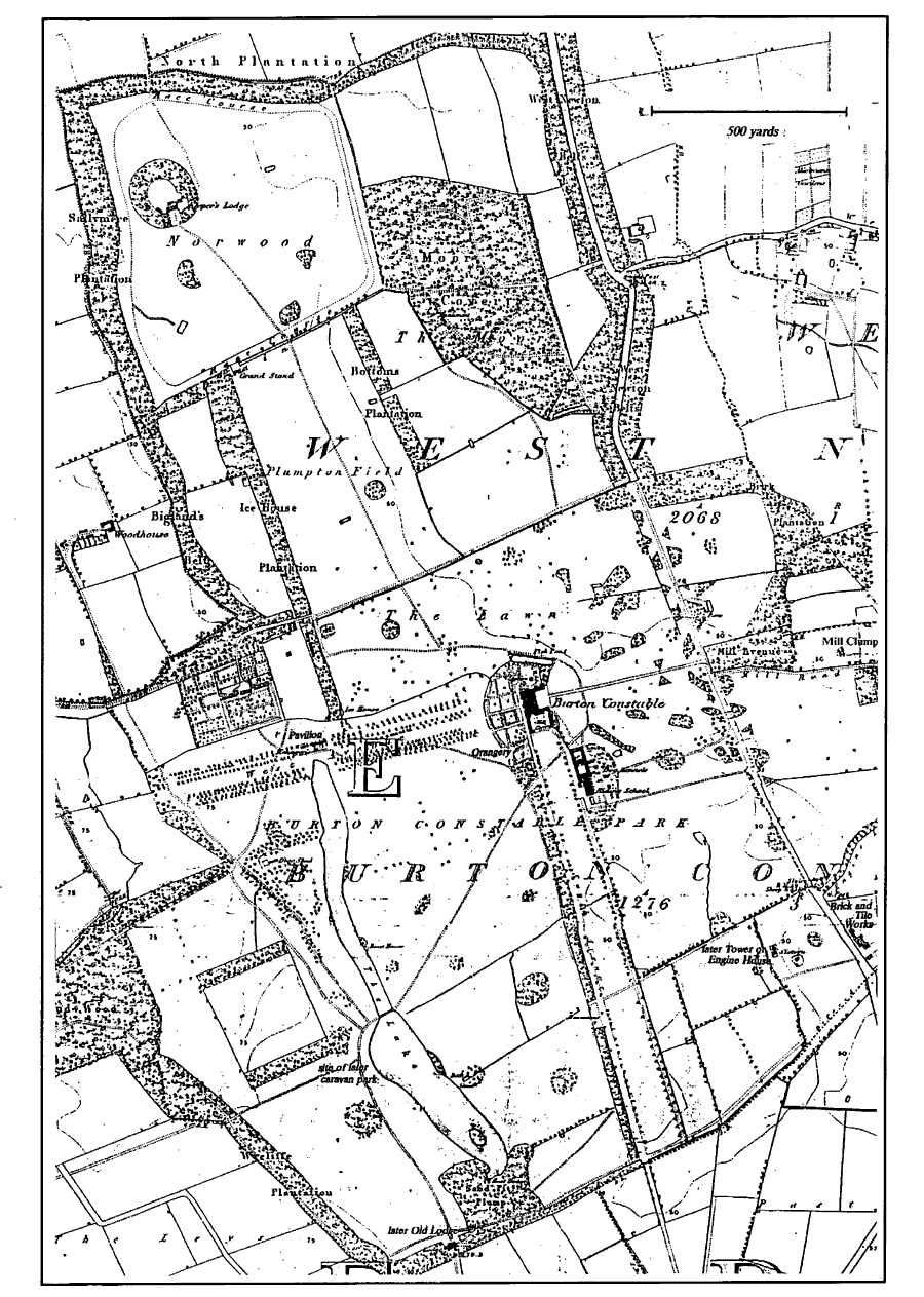
Burton Constable in 1852
The rectorial tithes of Burton Constable were sold by William Thornton to Cuthbert Constable in 1738, (fn. 91) and were evidently later merged.
ECONOMIC HISTORY
COMMON LANDS AND INCLOSURE
In 1086 there were five ploughlands at Burton Constable but only one plough was then worked, on the demesne. (fn. 92) The open fields of Burton Constable included East field in 1447, and there was evidently also a western field or fields. (fn. 93) They had probably been converted to grassland by the 1560s, when evidence from tithe disputes suggests a prevalence of grassland and of pastoral farming there. (fn. 94) By 1621 the former East field was almost certainly represented by the 173-a. Mill field, East close, of 85 a., the 10-a. Paddock, and closes called Pailer field and Brick field, each of c. 50 a. Ridge and furrow could be seen throughout the east of the township in the 1940s, (fn. 95) and was evident still in the 1990s east of the Hall and on the southern boundary near Tower House. Ridge and furrow north-west of the Hall and elsewhere in the west of the township. (fn. 96) suggests that the western field or fields had included the almost 400 a. which in 1621 lay in Plumpton field, Backhouse field, the Frith, the Brooms, and the Leys. Most of the western closes had apparently by then been emparked. (fn. 97)
In 1447 North, West, and White carrs provided grazing, and North and White carrs also meadow land. (fn. 98) Rough grazing may also have been enjoyed on the moor, later the Moors, but that area had evidently been inclosed by 1621, and in 1636 inhabitants of West Newton were presented for taking the lord's furze there. (fn. 99)
WOODLAND
A wood recorded from 1294 (fn. 100) comprised 49 a. of woodland and 11 a. of pasture, all inclosed by a ditch, in 1336, when 7 a. of the underwood was cropped each year. (fn. 101) It was probably that wood which was called North wood, or Norwood, from the 15th century, when the lord's fisheries were also mentioned there; (fn. 102) other woodland, then named Westwood, was presumably that later called Yaud, or Old, wood. (fn. 103) The 94 a. of inclosed woodland recorded in 1578 was evidently Norwood, which in the 17th and 18th centuries comprised c. 105 a.; Yaud wood was not mentioned in 1578 but in the later period was of 20-25 a. (fn. 104) Much of the business of Burton Constable court from the 16th century was concerned with preventing passage through Norwood and unlicensed wood- and nutgathering, and in 1611 the taking of eggs, young pheasants, bittern, and heron there was expressly forbidden. (fn. 105) Edward Constable sold over 700 ash trees in Norwood in the late 1790s, and there was then little woodland until new plantations were made in the 1820s. (fn. 106) By 1852 the area of woodland in the township had been more or less restored by the planting of Moor covert and belts of woodland, notably along the road and around the northern and western boundaries. (fn. 107) The woodlands of Burton Constable accounted for most of the 300 a. bearing trees there and in West Newton in 1905, and they were little changed thereafter. (fn. 108)
RECENT AGRICULTURE
In 1987 the 1,890 ha. (4,670 a.) returned under Burton Constable civil parish evidently included much land elsewhere, while apparently excluding at least part of the Hall's grounds. (fn. 109) Of the area given, 1,558 ha. (3,850 a.) were arable land and 320 ha. (791 a.) grassland; there were then more than 4,000 pigs and 2,000 poultry, and c. 400 sheep and the same number of cattle. The arable land included 75.4 ha. (186 a.) of field vegetables. (fn. 110)
In 1774 seven tenants held 530 a. of Burton Constable: one farm was of 224 a., another of 112 a., two of 50-99 a., one of 34 a., and there were two holdings of c. 10 a. each. (fn. 111) In the 19th century and earlier 20th most of the land was evidently managed by a bailiff as part of the Burton Constable Hall estate; there were also two farms, of 125 a. and 159 a., in 1851 and later up to five small farms. (fn. 112) A firm of nurserymen, also working at Coniston, rented c. 12 a. of gardens and hot-houses at the Hall from about 1880 until c. 1950. (fn. 113) A cowkeeper also worked at Burton Constable. (fn. 114) There were 15 holdings returned under Burton Constable civil parish in 1987, of which four were of 200-499 ha. (494- 1,233 a.), one of 100-199 ha. (247-492 a.), four of 50-99 ha. (124-245 a.), and six of 10-49 ha. (25-121 a.). (fn. 115)
INDUSTRY
Brick field was named in 1621, (fn. 116) bricks for the building works at the Hall were burnt locally in the 18th century, presumably in or near Brick Garth close, (fn. 117) and there was a yard on the southern boundary in the mid 19th century. (fn. 118)
MILL
A windmill was recorded at Burton Constable in 1294, (fn. 119) and from the 17th to the mid 19th century a mill stood close to the eastern boundary. It was evidently demolished soon after 1828, but Mill clump and other placenames mark its site. (fn. 120)
LOCAL GOVERNMENT
Court records for Burton Constable manor include rolls for 1433-8, 1546-58, and 1593-1636, (fn. 121) a call roll of c. 1730, (fn. 122) and presentments from 1704 to 1789. (fn. 123) In the 15th century the manor comprised, besides Burton Constable, lands at West Marton, at Etherdwick, Tansterne, and West Newton, all in Aldbrough parish, at Owstwick in Roos, at Grimston in Garton, at Wassand in Sigglesthorne, and in Hilston and Sproatley parishes, but the court was mostly concerned with the agriculture and drainage of Burton Constable and West Newton. Officers elected included four manorial reeves, two wood-reeves, two millreeves, two 'gripp-', or dike-, reeves, an aletaster, and a constable for the hamlet. In the mid 16th century the court, which had view of frankpledge, also appointed a bylawman for Burton Constable. There were two meetings a year in the 18th century, when the courts were held at Marton and West Newton.
Burton Constable hamlet joined Skirlaugh poor-law union in 1837. (fn. 124) As part of West Newton with Burton Constable civil parish, it remained in Skirlaugh rural district until 1935. With the rest of the enlarged civil parish of Burton Constable, it was then taken into the new Holderness rural district and at reorganization in 1974 was incorporated in the Holderness district of Humberside. (fn. 125) In 1996 Burton Constable parish became part of a new East Riding unitary area. (fn. 126)
CHURCH
A 'chantry chaplain of Burton' was mentioned in the 1430s and a 'parish priest of Burton Constable' later in the century, and at its dissolution Swine priory was paying a wage to a curate there. (fn. 127) There was also said to have been a chapel of Burton Constable, endowed with tithes in that township, presumably by the priory as rector. (fn. 128) Although there may have been a chantry associated with the chapel in the Hall, most of this evidence probably relates to nearby Marton chapel. (fn. 129)
ROMAN CATHOLICISM
The Constables of Burton Constable were probably the most influential of the Roman Catholic families in Swine parish. (fn. 130) Their tenants and servants presumably worshipped in the family's chapel at the Hall until the later 17th century, when a mission was established nearby at Marton for most of them. (fn. 131) The chapel at the Hall was very likely one of the two Roman Catholic chapels, each with its own priest, recorded in Swine parish in 1743; it was still used occasionally in 1994. (fn. 132)
EDUCATION
Children from Burton Constable have gone to school at Marton, Ellerby, and Sproatley. (fn. 133)
CHARITY FOR THE POOR
Little is known of the administration of a charity for the poor of Burton Constable which was created by deed of 1770 and endowed with 12 a. A Scheme obtained in 1982 allowed the charity to be run as a relief in need trust for inhabitants of Burton Constable civil parish with a smaller charity benefiting Sproatley. (fn. 134) In 1985-6 the annual income of the two charities was almost £800, but no grants were made and there was a final balance of nearly £4,000. (fn. 135)