A History of the County of York East Riding: Volume 7, Holderness Wapentake, Middle and North Divisions. Originally published by Victoria County History, London, 2002.
This free content was digitised by double rekeying. All rights reserved.
K J Allison, A P Baggs, T N Cooper, C Davidson-Cragoe, J Walker, 'Middle division: Wawne', in A History of the County of York East Riding: Volume 7, Holderness Wapentake, Middle and North Divisions, ed. G H R Kent (London, 2002), British History Online https://www.british-history.ac.uk/vch/yorks/east/vol7/pp181-204 [accessed 30 April 2025].
K J Allison, A P Baggs, T N Cooper, C Davidson-Cragoe, J Walker, 'Middle division: Wawne', in A History of the County of York East Riding: Volume 7, Holderness Wapentake, Middle and North Divisions. Edited by G H R Kent (London, 2002), British History Online, accessed April 30, 2025, https://www.british-history.ac.uk/vch/yorks/east/vol7/pp181-204.
K J Allison, A P Baggs, T N Cooper, C Davidson-Cragoe, J Walker. "Middle division: Wawne". A History of the County of York East Riding: Volume 7, Holderness Wapentake, Middle and North Divisions. Ed. G H R Kent (London, 2002), British History Online. Web. 30 April 2025. https://www.british-history.ac.uk/vch/yorks/east/vol7/pp181-204.
In this section
WAWNE
THE parish of Wawne is situated on the east bank of the river Hull, c. 6 km. north of the centre of the city of Hull. (fn. 1) The ancient parish comprised, besides Wawne township, that of Meaux. The town of Beverley stands about 4 km. WNW. from Wawne, relatively inaccessible on the other side of the river, and the former village of Sutton on Hull is c. 3 km. to the south-east. Sutton was Wawne's 'south town', and its grounds, extending south almost to the river Humber and east to Bilton, in Swine, and containing also the settlements of Lopholme and Stoneferry and part of Drypool, lay within a very much larger parish of Wawne until the gradual creation during the Middle Ages of a separate parish of Sutton. (fn. 2) Bransholme, perhaps the largest of Hull's council estates, was built in Sutton in the 1960s and 1970s, and extended into the former township of Wawne in the latter decade. (fn. 3) The built-up area, which includes several schools, now ends only ½ km. south of Wawne village. (fn. 4) Further west, towards the river, another suburb, called Kingswood, was being built in 2000. The northern part of Wawne parish, which lies away from the river, comprised the township of Meaux, known chiefly as the site of a Cistercian monastery founded in 1150 or 1151. (fn. 5) The abbey has gone, leaving virtually no visible remains, and the place consists of a few scattered farms, c. 3 km. north of Wawne village.
The name Wawne, recorded as Wagene or Waghene in 1086, Waune in 1230, and Wawne in 1371, is believed to be wholly or partly Anglian and to mean a quagmire. (fn. 6) Meaux is thought to be a Scandinavian, or Anglo-Scandinavian, compound word referring to a sandbank in a pool or lake. Its occurrence in 1086, as Melse, weakens the legend in the Meaux chronicle that the place was named by the first Norman tenants of the estate after their native town of Meaux (Seine et Marne), in Latin Meldis. The association of the two names by the monks is, however, thought to have helped the name to shift from Melse, or Melsa, (fn. 7) to Meaux, which was in use by 1291. (fn. 8)
The boundaries of Wawne, Meaux, and neighbouring settlements were defined soon after the Conquest, and those of Meaux township were described again c. 1400. (fn. 9) In the 1520s some maintained that Wawne parish extended as far south as Drypool and east as Bilton and included Sutton and one or two smaller places, but much of that area was then claimed for the emerging independent parish of Sutton. (fn. 10) The parish and township boundaries were formed almost entirely by watercourses, chief among them the river Hull which flowed down the western boundary of Wawne township; the river and the lesser drains are discussed in detail below. (fn. 11) The boundary between Wawne township and Benningholme, in Swine parish, has since the 1750s been formed by a ditch and bank made then to divide Wawne common. (fn. 12)
By 1852 Wawne ecclesiastical parish, no longer including Sutton, contained 5,440 a. (2,201.6 ha.), comprising 3,983 a. (1,611.9 ha.) in Wawne township and 1,457 a. (589.7 ha.) in that of Meaux. (fn. 13) Meaux township, later civil parish, included a detached area of former woodland in Routh parish until, apparently in the 1880s, that land was added to Routh, leaving Meaux with 1,409 a. (570.2 ha.). Wawne township was reduced at the same time by 265 a. (107.3 ha.) to 3,718 a. (1,504.7 ha.); the reason is unknown. (fn. 14) In 1935 the 5,127 a. (2,074.9 ha.) of Wawne and Meaux civil parishes was added to almost the whole of Sutton on Hull civil parish to form a new civil parish of Wawne, with 7,256 a. (2,936. 5 ha.). (fn. 15) The extension of the Hull city boundary in 1968 reduced Wawne civil parish by 1,178 ha. (2,911 a.), and re-measurement may account for a further reduction of 7 ha. (17 a.) between 1981 and 1991, leaving Wawne civil parish with 1,751 ha. (4,327 a.). (fn. 16)
Many people in the parish presumably died from plague in 1349, when only 10 of the 50 monks and lay brothers in Meaux abbey survived. (fn. 17) There were said to be 100 households in Wawne township c. 1570. (fn. 18) Wawne, including a few houses in the liberty of St. Peter's, York, and evidently also those at Meaux, had 77 houses assessed for hearth tax in 1672. (fn. 19) There were 43 families in the parish in 1743, and 36 in 1764. (fn. 20) The population of Wawne township fell from 299 in 1801 to 250 in 1811. Growth was resumed, however, in the 1850s, and by 1871 there were 353 inhabitants. After a decline in the 1870s, numbers recovered to 317 in 1891 and reached 374 in 1921. In 1931 the civil parish had 335 inhabitants. In Meaux township the population increased more or less steadily during the early and mid 19th century, from 49 in 1801 to 101 in 1881, but then fell to 72 in 1911 and stood at 73 in 1931. As constituted in 1935, the new civil parish of Wawne would have had a total population in 1931 of 604, including 196 in Sutton; in 1951, when a large military depot remained in Sutton, there were 1,097 inhabitants, (fn. 21) and 630 were recorded in 1961. The part of Wawne civil parish which remained after the expansion of Hull in 1968 had accommodated 376 people in 1961; that population had grown to 1,142 by 1971, but then fell back, to 1,084 in 1981 and 997 in 1991, of whom 963 were actually counted. (fn. 22)
The parish lies mostly between 1.5 m. and 8 m. above sea level. Much of the lowest ground is found on the margins of the parish, beside the river and the main drains, and that is covered with alluvium. (fn. 23) Deposits of boulder clay produce a large broken ridge of higher land running north-south through the middle of the parish and reaching 11 m. in the south of Wawne township. The open fields of Wawne were sited on the higher land, which also provided the sites for the settlements of Wawne and Meaux, and for Meaux abbey. More modest rises in level in Meaux overlie sand and gravel deposits there, which have been dug on a small scale. (fn. 24) The extensive lower grounds of the parish were used chiefly as meadows and pastures. Inclosure in Wawne township was evidently piecemeal, but much of its commonable ground, including the open fields, seem to have been dealt with in the later 17th or early 18th century. (fn. 25)
The parish is drained southwards towards the river Humber, chiefly by the river Hull and the Holderness drain. Flood banks confining the river had evidently been made by the 13th cent ury, when a seadike was recorded in Wawne. Land reclaimed from the river by embankment perhaps included that known as Greilak in the 13th century, later as Graylake, and eventually as Grey Legs. (fn. 26) The Holderness drain was formerly represented by a stream, or streams, flowing into Old fleet. (fn. 27)
The local drainage was evidently much altered by Meaux abbey and other landowners. (fn. 28) Between 1160 and 1182 a stream running along the boundary between Routh and Riston and then through Meaux was enlarged or diverted in Wawne as Eschedike, later Ash dike, to give the abbey a navigable link to the river Hull. (fn. 29) In the early 13th century, by agreement with Swine priory, some of the water of Lambwath stream was diverted into a new drain, later, as in the case of a near-by watercourse, (fn. 30) called Monk dike. Monk dike flowed into the parish along the boundary between Arnold and Benningholme townships, both in Swine parish, and then divided into two channels running north and south of the abbey's woodland before rejoining to fall into Ash dike. The northern branch was evidently intended to supply water to the abbey mill. (fn. 31) The southern channel probably later formed the boundary between Meaux and Wawne, and is now represented by Arnold and Riston drain and part of the Holderness drain. (fn. 32) The rest of the water from the Lambwath valley flowed into the Hull through the ditches separating Wawne from Swine and Sutton, later called respectively Head or Moor dike and Forge, Forth, or Fore dike, now Foredyke stream and Wawne drain. (fn. 33) Forth dike was made or improved to form the boundary between Wawne and Sutton in the earlier 13th century by agreement between Sir Saer of Sutton and other proprietors in Sutton, Peter of Wawne, and Meaux abbey; the ditch was to be navigable and in part comprised two channels. (fn. 34)
Other drains recorded in the Middle Ages included those running along the east, west, and north sides of Meaux township. The eastern drain, Wyth, later Monk, dike, was evidently also made or improved by the abbey. (fn. 35) Park dike, which flows down the western boundary, was said to have been made by William le Gros, count of Aumale, in the 12th century to enclose one side of his projected park at Meaux; it now forms part of the Holderness drain. (fn. 36) Park dike and a continuation flowing along the northwestern boundary of Wawne township to the river Hull were known as Skaith, or Double, dike by 1433. (fn. 37) The northern boundary drain, later the Routh and Meaux drain, had been made or improved by the abbey by 1286. (fn. 38)
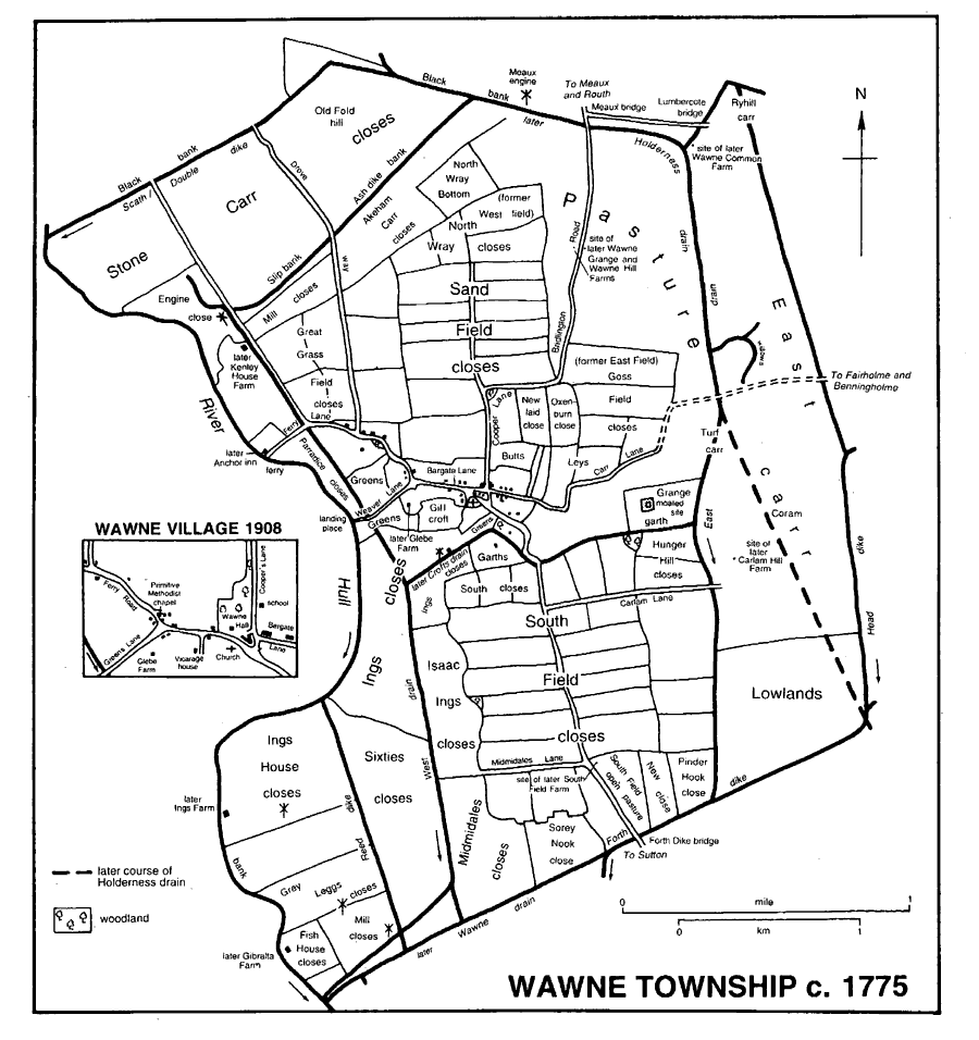
Wawne Township c.1755
The drainage of the parish was said to have been injured on occasion by the abbey's works: in the 13th century the abbey allegedly caused flooding in the pasture next to Ash dike and in a meadow near its mill and fishery, (fn. 39) and in 1367 Monk dike was said to have been hindered by water being taken in from the river for the mill on Ash dike. (fn. 40) In 1436 it was, however, the abbey's neglect of drains in Wawne parish and elsewhere which was given as the reason for flooding in Leven. (fn. 41)
The Court of Sewers for the East Parts of the East Riding was responsible for the drainage from the 16th century, when there was apparently a mere south of the village (fn. 42) and when much of Wawne and Meaux was said to be frequently under water. (fn. 43) In 1580 the court made a new drain, later East drain, (fn. 44) through Wawne township linking Monk dike to Forth dike. (fn. 45) It was, nevertheless, reckoned in 1650 that 1,800 a. in Wawne was poorly drained. (fn. 46) The drainage of the west side of Wawne was improved by Sir Joseph Ashe, lord of Wawne, in 1675. His scheme involved the construction of banks around the low grounds, notably along the northern side of Wawne lordship where a 'great bank' flanked by dikes called Black, or Stone Carr, bank was made; the cutting of a new drain from the carrs to the outfall of Forth dike into the river, and the building of drainage windmills to assist the new drain, which was consequently called Engine, or West, drain. Ash dike was then also made to flow in a contrary direction, falling into the East drain rather than the river. (fn. 47) In the 18th century two wind-powered drainage engines, the 'great' and Kenley engines, were employed in the drainage of Stone carr, (fn. 48) and in the 1770s two mills were shown beside West drain, another, the 'Meaux engine', beside the embanked north-eastern boundary, and three others, apparently smaller devices, near the river south of the village. (fn. 49) The drainage of Wawne, Meaux, and other parts of the east side of the Hull valley was further improved under the Holderness Drainage Acts of 1764 and later. (fn. 50) The area rated to the work of the Holderness Drainage Board in 1775 included 733 a. in Wawne and 502 a. in Meaux, (fn. 51) and 682 a. and 640 a. respectively were assessed in 1833. (fn. 52) Forth dike was diverted away from the outfall in Wawne by the making of a new course to the river through Sutton c. 1765; the westernmost part of Forth dike was subsequently called Wawne drain. (fn. 53) Soon afterwards the Board constructed a new main drain to a lower point in the river Hull. The work in Wawne township was evidently done in, or shortly before, 1779, (fn. 54) and involved the cutting of a channel from the northern part of East drain to the south-eastern corner of the parish, where the new Holderness drain was culverted under Forth dike. (fn. 55) Despite the improvements, there was flooding in the carrs at Wawne in the 1780s, but in the earlier 19th century the drainage was made more effective by re-routing the main drain to fall directly into the river Humber. (fn. 56) Responsibility for the main drains later passed in turn to the River Hull Catchment Board, the Hull and East Yorkshire River Board, and the Yorkshire Water Authority, and in 2000 it belonged to the Environment Agency. (fn. 57) The development of the south-western corner of Wawne in the 1990s was accompanied by changes in the drainage there, notably by the culverting of part of Engine drain.
Besides being for long the main drain of the parish, the river Hull was also an important navigation. In 1269 the archbishop of York assigned most of the annual rent he received from Meaux abbey for his land in Wawne to Joan de Stutville, lady of Cottingham manor, in return for her removal from the river of weirs and other barriers to the archbishop's boats going between Beverley and the Humber. (fn. 58) Wawne village itself had a landing stage beside the river. (fn. 59)
The archbishop of York, or the count of Aumale as his tenant, had a ferry across the river Hull at Wawne, which passed with land there to Meaux abbey in the mid 12th century. (fn. 60) In 1584 the Crown leased the river crossing to Lancelot Alford, the Wawne half, with the boat and tolls, as the abbey's successor, and the other half, presumably, as later, from Thearne, in Beverley, as the then owner by exchange of the archbishop of York's manor of Beverley. (fn. 61) The ferry from Wawne later belonged, with the manor there, to Sir Joseph Ashe, Bt., and his successors. (fn. 62) A new dock was made c. 1780. (fn. 63) The river Hull was occasionally shallow enough to be forded at the ferry crossing, the worst barrier in the river, and dredging was undertaken in 1721 and again in the 1880s. (fn. 64) By the early 20th century a floating bridge controlled by chains was used for horses and carts, and a punt for foot passengers. (fn. 65) The length of the journey to Hull by way of the ferry then prompted suggestions for other crossings in the south of Wawne. In 1913 a floating bridge or ferry boat to Dunswell, in Cottingham, was mentioned, and a new private ferry was then proposed for a site further south, close to the township boundary. During the protracted negotiations with the drainage authorities responsible for either bank and with the river authority, a swing bridge at the existing ferry site was suggested, and the southern scheme was altered from a ferry bridge to a moveable bridge, before being abandoned because of the war and continued official opposition. (fn. 66) Wawne ferry ceased to be operated in or shortly before 1947. (fn. 67)
Almost the only road in the parish is the minor one running north-south along the higher ground through the two settlements, to Routh and the main Beverley–Bridlington road in the north and to Bransholme, Sutton, and Hull in the south. A short lane, called Ferry Lane in 1639 and later Ferry Road, (fn. 68) links the village and the river Hull, and another runs along the Wawne–Meaux boundary to Benningholme, but otherwise the parish depends on field roads. Between Wawne village and Meaux the chief road was called Cooper Lane and Burlington Road in 1734, (fn. 69) and later just Cooper's Lane; the part south of Wawne village has been known as Sutton Road. (fn. 70) The latter is carried over the southern boundary drain by Foredyke bridge, (fn. 71) probably the Forthcross bridge recorded in the 13th century and the 15th-century Forth bridge. (fn. 72) The turnpiking of the main road, and of the side road to the ferry which was then to continue over a bridge to join the Beverley–Hull turnpike road in Thearne, was proposed in the later 1760s but came to nothing. (fn. 73) The busy road remains relatively unimproved, but a section in Meaux was straightened c. 1970. (fn. 74)
WAWNE village was built on higher ground in the middle of the township. (fn. 75) The early plan may have comprised two discrete greens with a connecting east-west street, later Bargate Lane, leading through the settlement's open fields. Most of the village, including the church, stood on or around the larger eastern green, which extended south across the shallow valley of a stream, later improved as Crofts drain. The village was clearly extensive by the 12th century, when its buildings included some on the lower southern land. Earthworks excavated there before their destruction in the 1960s revealed several phases of medieval building, and possibly some replanning, but the site was largely abandoned in the 16th or 17th century; the last building was removed in the late 18th century. That field was then called Garths, later Crofts garth, and other closes there and in the west of the village, where similar evidence of medieval occupation and later abandonment was found, were named Greens. The sale of the manor of Wawne in 1651 to (Sir) Joseph Ashe (Bt.) and his subsequent acquisition of tenancies there may account for the reduction in the size of the village. (fn. 76) Vestiges of the former greens remained in the shrunken village. Some houses had been said in 1566 to stand 'in a circle near the church', (fn. 77) and in the later 18th century there was an open area north of the church, and, further east, 'islands' of houses and garths, almost certainly encroachments on the waste. The former green was then crossed by a lane, probably earlier realigned, leading south-eastwards to the stream, (fn. 78) by another leading north to Meaux, and by Bargate Lane, which was continued eastwards into the carrs. At the west end of the village, Bargate Lane divided at the supposed green there: Ferry Lane or Road led north and west to connect the village to its crossing to Beverley, and Weaver Lane, later Greens Lane, ran southwestwards to the landing place. The street pattern was altered later in the 18th century or in the earlier 19th, when part of Bargate Lane was taken into the grounds of the chief house, later Wawne Hall; the remaining western stretch and part of the southern lane later constituted Main Street, but the eastern end of the lane continued to be called Bargate Lane until the name was changed to Fairholme Lane in the mid 20th century. (fn. 79)
It was then that the still small village began to grow. The district council put up eight houses beside the lane to Meaux, formerly Cooper's Lane and now Meaux Road, before the Second World War, and about 1950 it built almost 30 more houses north of Main Street in Oak Square, named after the ancient trees which stand on the central green there. (fn. 80) Many private houses were also added by further ribbon development along Meaux Road; by piecemeal infilling of Main Street and Greens Lane; (fn. 81) and by the construction of small housing estates off Main Street, that to the north, called Windham Crescent, being built on the site of Wawne Hall in or soon after 1961, (fn. 82) and the southern one surrounding the former vicarage house, which was sold in 1963. (fn. 83) Wawne Hall and other buildings in the grounds were used during the Second World War as the headquarters of the antiaircraft batteries along the north bank of the Humber, and later part of the site became the county council's emergency defence and planning centre; a few buildings and radio masts remained behind Windham Crescent in 2000. (fn. 84) The district council provided a sewage disposal works beside Crofts drain about 1950, but that was later replaced (fn. 85) by a treatment works in Hull, built c. 1965, (fn. 86) and pumping stations in Glebe and Sutton Roads. (fn. 87)
Most of the buildings date from the 20th century, and, apart from the church, all are of brick. Earlier buildings include farmhouses and their outbuildings, of which No. 4 Main Street, Bamforth Farm, Ferry Road, and Grange Croft, off Sutton Road, may all date from the 18th century. (fn. 88) Several houses also remain from the improvements made to Wawne Hall and its surroundings by the chief landowner, the Windham family, in the late 19th and early 20th century. Gate Lodge (No. 32 Main Street) was designed by John Bilson and built in 1904; it has prominent pedimented gables with modillions, and, a recurring motif in the estate building of the village, diagonal chimney stacks. It was probably then that the adjoining row of singlestoreyed 18th-century cottages (now Nos. 34 and 36) and another range behind (Nos. 38 and 40) were remodelled; those fronting the street received most attention, and have Tudor-arched doorways and a flat-tiled crested roof with dormer windows and diagonal chimneys. A semi-detached pair of gabled houses (Nos. 21 and 23 Main Street) are also by Bilson, as may be the single-storeyed Nos. 50 and 52, with bargeboarded eaves, dormer windows, and, once again, diagonal stacks, and Nos. 17–19 Fairholme Lane, which have tile-hung gables. Other houses built on the manorial and rectorial estates are Glebe Farm Cottage (No. 41 Main Street) and the adjoining Glebe Cottage; No. 4 Ferry Road and its neighbour, Rose Cottage, both of one storey with dormers; Nos. 5 and 7 opposite, and the remodelled Smithy Farm, Fairholme Lane.
An alehouse at Wawne was mentioned in the 1590s, (fn. 89) and the Plough was named in 1666. (fn. 90) Wawne and Meaux each had one or two licensed houses in the later 18th century, but only one was recorded from the 1820s, the Anchor, or Windham Arms, at Wawne, which stood at the river crossing and was kept by the ferryman. (fn. 91) It was closed with the ferry in the 1940s, (fn. 92) and the building was later used as a farmhouse. The Waggoners Arms, on Sutton Road, was opened in the 1970s (fn. 93) and still traded in 2000. A small brick building was provided by the Windhams as a reading room c. 1900, and evidently so used until 1926, when a First World War wooden hut was erected adjoining the room for a village institute. That hut was later replaced by another, and in the later 1980s a new brick-built village hall was put up on the site. The former reading room next door was used for church meetings in 2000. (fn. 94) A library was run in Wawne Village Institute by the county council from 1960. (fn. 95) Before its 20th-century growth, the village had a cricket field on the south side of Main Street. That was replaced by another pitch, laid out on 1½ a. on the north side of Ferry Road, bought in 1963; in 1971 the parish council enlarged the site by c. ½ a., and in turn made tennis courts and a children's play area there. (fn. 96) A pavilion had been added by the 1980s. (fn. 97) Land south-east of the church was bought in 1966 for a new vicarage house but was later used instead for allotment gardens. (fn. 98)
OUTLYING BUILDINGS. A moated site c. ½ km. east of the church was probably that of Meaux abbey's grange at Wawne, established by 1177; (fn. 99) later called Paradise, the site stood in the 1770s in a close called Grange garth. Excavation indicates that occupation ceased c. 1500; (fn. 100) by the later 18th century the house later named Grange Croft Farm had been built nearer the village. (fn. 101) One or two of the outlying farmhouses in Wawne also occupied old sites. Gibralta Farm probably succeeded a medieval fish house belonging to the abbey, (fn. 102) and Ings Farm also existed by the 1770s; (fn. 103) both were demolished in the late 20th century. Kenley House Farm was probably named after the Caynglaik family, recorded in 1297: the house was named Kaynglayk in 1396 and Kainglie in the 16th century. (fn. 104) Several farmhouses were evidently built in the late 18th or early 19th century, following the completion of inclosure and improvements to the drainage: (fn. 105) Wawne Common, South Field, Carlam Hill Farms, and a pair called Wawne Grange Farm and East Field, or Wawne Hill, Farm, (fn. 106) had all been put by the 1820s, (fn. 107) and Carr House Farm was added soon afterwards (fn. 108) and rebuilt in the mid 20th century. South Field Farm was demolished for the development of the North Bransholme estate, and Wawne Hill and Carlam Hill Farms were derelict in 2000. Wawne Lodge had been put up by 1889, possibly for Ashe Windham the younger, who was living there in 1893, before moving to Wawne Hall. (fn. 109) It was apparently enlarged by Alexander Alec-Smith in the late 1930s, (fn. 110) but was also demolished when Hull's Bransholme estate was extended into Wawne in the 1970s. (fn. 111) Foxholme Farm was evidently added in the early 20th century. (fn. 112)
MEAUX. vill or manor is said to have stood just over 1 km. north-east of the site near the southern township boundary chosen for Meaux abbey in the mid 12th century, and soon afterwards the earlier settlement was replaced by one of the abbey's farms, North grange. (fn. 113) A moated site near North Grange Farm, presumably that of the grange, has been excavated. (fn. 114) The abbey had another grange in Meaux at Fewsome (Felsam), where there may already have been a farm when Meaux abbey was founded. (fn. 115) Apart from the abbey, other early buildings included a chantry chapel on the north side of the monastery. (fn. 116) Meaux abbey was demolished in the 1540s, (fn. 117) but the derelict Abbey Cottage off Tippett Lane may be a surviving building, or contain stone from the abbey. It is built partly of coursed rubble with some 13th-century stonework, and has a massive brick chimney stack dating from the 16th century. (fn. 118) After the abbey's removal, the hamlet comprised a few scattered farmhouses and their cottages. North Grange and Fewsome Grange, later Meaux Decoy Farm, were recorded again in 1650; both were evidently rebuilt later. (fn. 119) The present Meaux Decoy Farm may date from the 18th century but was refronted later and reduced and remodelled in the 20th century. Its farm buildings include a pigeon house. Wise's, or Stud, Farm was presumably one of the three farmhouses bought by Robert Wise in 1810. (fn. 120) Meaux Abbey Farm was built on the site of a former abbey sheepcote, evidently in the early 19th century, (fn. 121) and Little Decoy Farm had been added by Robert Harrison (d. 1821) or his successor Robert Harrison by 1828. (fn. 122) The latter had been abandoned by 2000, when little remained of the buildings. Abbey, later Crown, Farm was built between 1797 and 1828 by the Crown, which in the 1840s or early 1850s also rebuilt Bridge Farm (fn. 123) and in 1866 put up two cottages, later Bridge Cottage. (fn. 124) A mission chapel and nearby two cottages were added in the 1870s. (fn. 125)
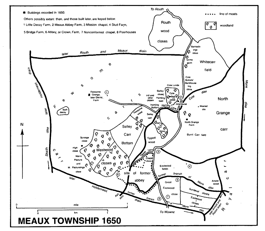
Meaux township 1650
The Bransholme estate was built between 1965 and 1983, mostly by Hull corporation as part of its programme of slum clearance and re-housing; its site and other land formerly belonging to Sutton and Wawne parishes was transferred to the city in 1968. (fn. 126) The southern part of the estate was finished first, North Bransholme being developed on some 500 a., formerly in Wawne parish, from c. 1975. (fn. 127) The completed estate, very largely made up of council housing, comprised nearly 9,000 dwellings, of which some 2,500 were in North Bransholme. In a wider area comprising Bransholme and the adjacent Sutton Fields estate, more than 13,000 dwellings were built between 1967 and 1983; nearly 11,000 were put up by Hull corporation, some 2,000 by private developers, and about 100 by a housing association. (fn. 128) Almost half of the public housing on the Bransholme estate was of new design, much being system-built to plans of the Yorkshire Development Group, but the one- and two-storeyed houses and flats put up in North Bransholme were more traditional in their lay-out and materials. (fn. 129) Several schools were built in North Bransholme, (fn. 130) and social facilities were largely associated with them. A temporary building for social events was put up at the Dales schools in 1982, land there was developed by the school for community use in the late 1980s, and the estate as a whole was then provided with a library and sports facilities in the new Perronet Thompson school. (fn. 131) Earlier a play area had been laid out for North Bransholme, and in 1980 a prefabricated social hall was opened on Lothian Way; (fn. 132) by 2000 that hall had been demolished, and accommodation in the shopping centre opposite was being used for a community meeting place. Licensed premises then included Skippers tavern and the Pennine Rambler. The commercial centre of Bransholme is in the southern part of the estate, but North Bransholme has a small shopping centre off Grampian Way. (fn. 133) A temporary surgery was later replaced by a health centre in a redundant school. (fn. 134) In the 1990s Bransholme was said to suffer from vandalism, and North Bransholme, in particular, was classified as an area of social deprivation. (fn. 135) Many of the houses in North Bransholme were unoccupied in 2000, some were then being demolished, and the large open areas between them contributed to a bleak aspect.
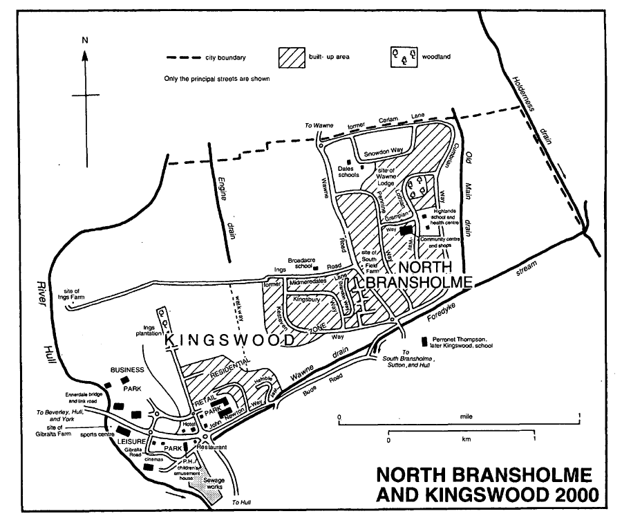
North Bransholme and Kingswood 2000
The corporation's North Bransholme estate extended across to the west side of Wawne Road, where closer-built terraces and semi-detached houses were put up. Development was continued westwards by the building of streets of private houses, (fn. 136) roughly parallel to those of the corporation, on land bounded on the south by Kesteven Way and to the north by Ings Road. In the 1990s a new suburb called KINGSWOOD was planned for the large area remaining between North Bransholme and the river Hull. Some 5,000 homes, 3,000 of them privately and 2,000 publicly owned, were proposed for the 320-ha. site, which was expected to take ten to fifteen years to complete. (fn. 137) A supermarket was opened in 1996, and the next year a road connecting the area to the Hull–Beverley road was inaugurated, together with its bridge over the river Hull. Soon afterwards a hotel was opened, (fn. 138) and by 2000 the retail area comprised about six large shops and an eating house, while on the south side of the new road a leisure park already included a large sports centre, a cinema complex, another restaurant, and a combined public house and children's play house. The residential area was intended to comprise many relatively small and discrete closes, of which Chevening Park and Bushey Park, north and east of the shops, and further east Hunter's Croft, off Kesteven Way, Harvester Court, and Regent's Mead, off Kingsbury Way, were all in progress in 2000. Close to the river the first buildings of Kingswood's business park, four hangars, were also put up in 2000.
MANORS AND OTHER ESTATES
In 1086 the archbishop of York held between 2 and 3 carucates at Wawne as a berewick of his manor of Beverley. (fn. 139) The archbishop's holding descended with Beverley, later Beverley Water Towns, manor, passing from the archbishop to the Crown by exchange in 1542, to Sir Michael Warton by sale in 1628, and later belonging to Warton's heirs. The land in Wawne was held of the archbishop and his successors for £5 a year from the 13th century. (fn. 140) The rent from Wawne was sold with Beverley Water Towns manor by Charles Pelham, Lord Yarborough, to Richard Dickson in 1827, (fn. 141) and it presumably continued to descend with that estate.
In 1066 Ulf held 7 carucates in Wawne and 2 carucates in Meaux as soke of his manor of Aldbrough; both holdings had passed to Drew de Bevrère by 1086, (fn. 142) and they were later parts of the Aumale fee. Sir Basyng of Wawne, mentioned as lord of Wawne after the Conquest, (fn. 143) was presumably the tenant under Drew or one of his successors. In 1270 the Aumale fee was said to include WAWNE manor. (fn. 144) The counts of Aumale also held the rest of Wawne under the archbishop. (fn. 145)
The earliest known tenant at Meaux was Gamel son of Ketel (fl. later 11th cent.). About 1150 Gamel's son or grandson John of Meaux exchanged the holding with his lord, William le Gros, count of Aumale, for Bewick, in Aldbrough. The count intended making a park at Meaux, (fn. 146) but soon afterwards he gave the 2 or 3 carucates to Cistercian monks as the site for the abbey of St. Mary at Meaux, together with all his land in Wawne, comprising the 8-carucate Aumale fee and the c. 2 carucates held of the archbishop. (fn. 147) The land belonging to the archbishop's fee was resumed by archbishop Roger soon afterwards, only being regained 40 years later c. 1200, and in the 1220s and the later 14th century archbishops unsuccessfully claimed the whole of Wawne as their fee. (fn. 148) The abbey's estate in Wawne was enlarged with the smaller gifts of Reiner of Sutton, Robert of Meaux, and Sir Peter of Wawne in the later 12th century, (fn. 149) and afterwards by those of, among others, Sir Peter's heirs. (fn. 150) In 1294 the Crown granted a 4-bovate farm there as part of the exchange for Wyke and Myton, later Kingston upon Hull. A grant of free warren in Meaux and Wawne, including the lands of North grange and Fish house, had been received in 1293, (fn. 151) and in 1316 the abbot of Meaux was recorded as lord of 'Waxan', possibly meaning Wawne. (fn. 152) The abbey's manor of WAWNE was referred to later in the 14th century, (fn. 153) and in 1535 the house's estate in the parish comprised a reputed manor of MEAUX and the site of the abbey, valued at £24 a year, and lands and houses in Wawne, valued at almost £36 10s. (fn. 154) The abbey was surrendered to the Crown in 1539. (fn. 155)
Meaux abbey, the history of which is treated elsewhere, (fn. 156) was demolished in 1542, much of the stone apparently being used for Henry VIII's contemporary fortification of Hull, (fn. 157) and by the 19th century little remained apart from moats and some walling with a gateway. The site was excavated in the 18th century for hardcore for roads (fn. 158) and again more sympathetically in the 1830s, (fn. 159) c. 1880, (fn. 160) and in the earlier 20th century. (fn. 161) In 1980 the earthworks were surveyed. (fn. 162) A now derelict cottage on the site is partly of ashlar, which may have come from the abbey. (fn. 163)
The part of Meaux abbey's former estate which made up WAWNE manor remained with the Crown until the earlier 17th century. The net value, composed of rents and court profits, was then c. £105. The manor was pledged as security for the city of London's loan to the Crown in 1625, and in 1628 it was sold in fee farm to the Ditchfield grantees. (fn. 164) One of the farms was sold in 1629, and in 1651 Joseph Ashe and his trustees, Edward and Jonathan Ashe, members of a London merchant family, bought the rest of the manor from the city. (fn. 165) Joseph Ashe, later Sir Joseph Ashe, Bt., enlarged his estate in Wawne by purchasing several freehold and leasehold estates. (fn. 166) Sir Joseph (d. by 1690) was succeeded by his widow Mary and then by their son, Sir James Ashe, Bt., (fn. 167) whose daughter and heir Martha married Joseph Windham. By 1734 the Windhams' estate in the parish had been further enlarged by purchase. Windham, later Joseph Windham Ashe, died in 1746, and was succeeded by John Windham, husband of the Windham Ashes' daughter Mary. (fn. 168) John Windham, later John Windham Bowyer, bought c. 100 a. in Wawne from J. C. Crowle in 1776, (fn. 169) and died in 1780. He was succeeded by his widow Mary (d. 1789), and then by their son Joseph Windham (d. 1810), who left Wawne to his sister Anne, wife of Sir William Smyth, Bt. (fn. 170) Anne (d. 1815) and Sir William (d. 1823) were succeeded by their son Joseph Smyth, who then assumed the name and arms of Windham. (fn. 171) In 1846 Joseph Smyth Windham owned c. 3,320 a. of Wawne township. (fn. 172) After his death in 1857, Wawne passed in turn to his sons, William Smyth, who took the name Windham and died in 1887, and Ashe, who substituted Windham for Smyth Windham. Ashe (d. 1909) was succeeded by his son, Ashe Windham, (fn. 173) who sold almost 2,690 a. in lots in 1912. (fn. 174) Some 750 a. of the estate remained to the Windhams in 1915. (fn. 175) Wawne Hill farm with 123 a. was sold in 1920, Wawne Lodge with 16 a. to Alexander Smith, later Alec-Smith, a Hull timber merchant, in 1923, and the 482-a. Grange Croft farm in 1935. (fn. 176) Ashe Windham (d. 1937) was succeeded by his son, (Sir) Ralph Windham, (fn. 177) from whom J. R. Beaulah bought Home farm, of 117 a., in 1951. (fn. 178) The 334-a. Ings farm, bought by Ashe Windham in 1932, was left to his wife Cora, who sold it in 1948 to Leonard Smith. (fn. 179)
The chief house stood on the north side of Bargate Lane in the 1770s. (fn. 180) Later in that century or in the early 19th, the 18th-century house was enlarged as Wawne Hall, and its grounds were extended north and south, encompassing part of Bargate Lane in the process. (fn. 181) The Hall was evidently often let, but from the 1890s until the early 1920s the Windhams resided, and the house was then again enlarged and remodelled in a Tudor style. (fn. 182) Its grounds extended over 18 a. in 1910. (fn. 183) The house was requisitioned during the Second World War, and in 1951 it and 7 a. were bought by the War Office; soon afterwards the house was demolished. (fn. 184) In 1961 Sir Ralph Windham repurchased most of the land, and then sold it to Riplingham Estates Ltd. for housing. (fn. 185)
Edward Jellett and George Keeble, estate agents, bought some 1,190 a. of the Windham estate in 1912, (fn. 186) and then resold much of the land. The largest of their sales was to William Nettleton, who bought 345 a. in Wawne Common and Wawne Grange farms. (fn. 187) Jellett and Keeble retained Gibralta and Ings farms with c. 550 a. in 1919, when Keeble bought the 340-a. Carlam Hill farm. (fn. 188) The rest of the estate sold in 1912 comprised five farms and almost 1,500 a. The largest of those lots was the 413-a. Kenley House farm, which Thomas Weatherill bought. (fn. 189)
The later ownership of those farms has not been traced.
The so called manor of MEAUX evidently comprised the abbey site and the demesne, which included North and Fewsome granges, woods, fisheries, and, in Sutton parish, much meadowland and pasture. That part of the abbey's former estate was granted by the Crown in 1550 to John Dudley, earl of Warwick, later duke of Northumberland; forfeited by him in 1553; (fn. 190) re-granted to Lord Robert Dudley, later earl of Leicester, in 1561, (fn. 191) but returned by him to the Crown in the earlier 1570s. (fn. 192) The Crown's estate in Meaux and the other townships, by then reduced by some alienations, was settled on Queen Henrietta Maria in 1629, when its net value was just over £80 a year, (fn. 193) and it was later part of the jointure of Charles II's queen, Catherine of Braganza. (fn. 194)
Much of the estate in Meaux, Wawne, and Sutton was leased from the Crown by the Alfords in the 16th and earlier 17th century. (fn. 195) The Cornwallis family, lessees in the later 17th century, (fn. 196) were succeeded in the earlier 18th by the Hampdens and their assignee, Richard Crowle, a London lawyer. (fn. 197) Under an Act of 1755, the reversion was conveyed to Crowle's trustees in exchange for his freehold and leasehold near Windsor castle, (fn. 198) and in 1776 Crowle's son and heir, J. C. Crowle, divided and sold the former leasehold.
In Meaux township William Kirkby bought Fewsome Grange, or Decoy, farm with 365 a. and the 200-a. North Grange farm from J. C. Crowle in 1776. (fn. 199) North Grange farm was quickly re-sold. (fn. 200) Kirkby, who also held the lease of the 292-a. of remaining Crown land in Meaux, was succeeded at his death in 1800 by his widow Eliza or Elizabeth, (fn. 201) and in 1813 she conveyed both the freehold and leasehold estates to Kirkby's nephew, John Kirkby Picard. (fn. 202) Fewsome Grange, or Decoy, farm, then reduced by sales to 288 a., was bought from Picard and his assignees in bankruptcy in 1833 by William Scott (d. 1848 or 1849), (fn. 203) and in 1851 Scott's son William Richardson Scott sold the farm to Albert D. Denison, Baron Londesborough. (fn. 204) It later passed with Denison's larger estate in Routh to Sir Henry Samman, Bt., who sold the farm in Meaux, then of 327 a., to G. L. Cullington in 1938. (fn. 205) In 1970 Decoy farm was sold by Cullington to the trustees of Leonard Chamberlain's charities in Hull and Sutton on Hull, and they still owned the farm in 2000. (fn. 206)
North Grange farm was sold by Kirkby to Thomas Harrison in 1776, and by him in 1778 to William Keeling, who mortgaged the farm to W. S. Wotton. (fn. 207) Keeling's creditors seem later to have gained possession. (fn. 208) Wotton's interest passed to his brother in law Isaac Mark, who attempted foreclosure in or about 1788, and then, apparently under Wotton's will, to his neice Susannah Mark in 1798. (fn. 209) The mortgage was transferred in 1802 by Miss Mark to William Smith the elder (d. by 1815) and younger, and by Smith in 1816 to William Habbershaw (d. 1818 or 1819). (fn. 210) The farm was later held by Habbershaw's trustees until 1879, when Robert Habbershaw sold it to William Dale and William Lamplough. (fn. 211) In 1907 Dale sold North Grange farm to Aldam Pool (d. 1919). (fn. 212) The 185-a. farm was later held by Pool's widow Ada and then by trustees of his will, who in 1937 sold it to Henry, Sydney, and Roland Scales. (fn. 213) North Grange farm was bought by T. H. Jackson, a Cottingham fish merchant, in 1942, (fn. 214) and in 1952 by Leonard Overend, a market gardener, also of Cottingham. The Overend family still owned the farm in 2000. (fn. 215)
In Wawne township c. 100 a., fishing rights, and hen rents were sold by J. C. Crowle to John Windham Bowyer in 1776; (fn. 216) they later descended with Wawne manor.
The largely cleared former woodlands of the abbey, amounting to c. 290 a., remained with the Crown after the mid 18th-century exchange with Crowle. (fn. 217) The 50-a. Routh wood closes were sold to Henry Samman in 1908, (fn. 218) and Crown farm, with much of the remaining land, to the Farnabys in 1977. Bridge farm with 70 a. remained to the Crown in 2000. (fn. 219)
Part of the Crown's estate at Meaux, comprising the site of the former abbey and several closes, and accounting in all for £4 of the annual rental of £27 from the demesne, was granted in reversion to Sir Christopher Hatton in 1586. (fn. 220) Lancelot Alford, the lessee of the Crown's estate at Meaux; is said then to have bought the reversion from Hatton. Alford's uncle, Lancelot Alford (d. 1563), (fn. 221) had obtained a 21-year lease of Meaux in 1540; Sir William Cecil's servant Roger Alford bought land in Wawne from Cecil in 1551, and the younger Lancelot Alford was the Crown's lessee at Meaux from 1582. (fn. 222) Other land at Meaux, granted in 1587 to Henry Mappleton and Thomas Jones, similarly passed that year to Alford, (fn. 223) later Sir Lancelot Alford (d. 1617). His son and successor, Sir William Alford, bought another part of the former abbey's estate in Meaux in 1634; the purchase, rented for nearly £7 a year, had been granted in 1625 to Robert Carey, Lord Carey, and later sold by him to Francis Thorpe and Charles Collins, or Collier. (fn. 224) The enlarged estate later descended to William's daughter Dorothy, wife of Thomas Grantham, and their son Thomas (d. 1668). (fn. 225) Sometimes called MEAUX manor, it was later evidently held by Thomas's widow Frances (fl. 1690), and then in half shares by the Granthams' daughters, Dorothy Holt and Elizabeth Palmer, (fn. 226) before falling to the share of Mrs. Holt in 1698. In 1701 or 1702 Meaux passed to Mrs. Holt's daughter Frances and son in law James Winstanley, who sold the estate, then of nearly 500 a. divided between six farms, to Francis Stringer's executors in 1712. (fn. 227) Like an estate in Humbleton, Meaux later passed to the FitzWilliams. (fn. 228) In 1810 William WentworthFitzWilliam, Earl FitzWilliam, sold his 543-a. estate at Meaux to Robert Wise. (fn. 229) Wise (d. by 1818) (fn. 230) was succeeded by his son Robert (d. 1842), (fn. 231) who left the holding to his greatnephew, Robert Wise Richardson. (fn. 232) Richardson bought c. 85 a. more in Meaux in 1851. (fn. 233) He died in 1914, and in 1917 another Robert Wise Richardson, probably his son, sold Home and Coy farms with 470 a. to George Beaulah. (fn. 234) The rest of the Richardsons' estate in Meaux, the 157-a. Stud farm, was sold to Frederick Beaulah in 1952. (fn. 235) The trustees of Leonard Chamberlain's charity in Sutton on Hull bought George Beaulah's holding, then comprising Meaux Abbey farm with 487 a., in 1944, and it still belonged to the trust in 2000. (fn. 236)
The Alfords and their successors lived at Meaux from the 16th century: Lancelot Alford's house there was mentioned in the 1550s, (fn. 237) Sir William Alford was described as of Meaux in 1617, (fn. 238) and Mrs. Grantham, presumably Frances, widow of Thomas (d. 1668), occupied the largest house in the parish, with 16 hearths, in 1672. (fn. 239) The Alfords' house was wrongly identified in the 19th century with Meaux Grange, (fn. 240) later Meaux Abbey Farm. (fn. 241) That house had been built by 1828 on the site of a sheepcot which was still standing in 1797; it was perhaps put up for Robert Wise, the purchaser in 1810 of the Meaux abbey estate. (fn. 242) Wise's son Robert lived in the 'neat mansion' in 1840, (fn. 243) but his successor, Robert Wise Richardson, (fn. 244) gave up the house in the later 19th century, and it became a farmhouse. (fn. 245) Meaux Abbey Farm is built of red brick in header bond with a slate roof, and comprises a three-bayed block with single-storeyed side wings. The light of the doorway to the south front has Y-tracery, as does the dummy Venetian window in the right wing. Tiled paving taken from the foundations of the abbey church has been reset in the entrance hall, and the garden contains a tombstone and other stonework from the abbey. (fn. 246) There are extensive outbuildings around two yards on the north side of the house.
The manor of WAWNE RECTORY, occasionally called PREBEND'S manor, (fn. 247) belonged to the chancellor of York minster from the 13th century. (fn. 248) The estate was confiscated during the Interregnum and sold to Matthew Alured in 1651, (fn. 249) but the chancellor evidently regained it at the Restoration.
The rectory was leased from the late 14th century to the 16th to Meaux abbey for terms of many years at an annual rent of £20; from the 17th century the leases were for three lives. (fn. 250) Members of the Payler family of London were lessees from the late 16th century, (fn. 251) Edward Payler's widow Frances holding the estate, then said to be worth £110 or £125 a year, in 1650. (fn. 252) Joseph Ashe, later Sir Joseph Ashe, Bt., lord of the other manor of Wawne, bought up much of the copyhold in the 1650s and 1660s, and from 1665 he and his successors leased the rectory manor from the chancellor. From the mid 17th century the lessee paid an additional rent of £20 a year as an augmentation to the vicar of Wawne. (fn. 253)
The tithes of hay, wool, and lambs were reserved to the rector when the vicarage was ordained in 1244, (fn. 254) and later his tithes were said to include also those of corn, flax, and rape. (fn. 255) The tithes due from Meaux abbey were disputed on several occasions between the 12th century and the 14th; the house's privileges were acknowledged in the late 12th century in return for payment to Wawne church of two pounds of wax a year, but that composition was changed to a rent of £2 a year soon afterwards, and in 1257 a composition of £2 5s. a year was substituted. The last composition was still being paid to the chancellor in the 16th century, (fn. 256) but thereafter it fell into abeyance, and in 1822 the rector's attempt to take tithes from Meaux township was resisted by the proprietors, who successfully claimed that their lands were tithefree. (fn. 257) Nunkeeling priory compounded for rectorial tithes due from its estate in Wawne in 1273. (fn. 258) In the 16th century the hay tithes were said to be compounded for at the rate of 10d. a 'bovate'. (fn. 259) The tithes of Wawne township were commuted by award of 1846 and apportionment of 1847; rent charges amounting to £882 a year, and including £72 from the rectorial glebe, were then awarded to the chancellor for his tithes. (fn. 260) The rent charges were transferred to the see of York in 1861, and in 1869 they passed by exchange to the Ecclesiastical Commissioners. (fn. 261)
Besides tithes, the rectorial estate comprised 1 carucate and 4½ bovates, 15 houses, and c. 35 a., mostly held by copyholders for some £3 a year; court profits, and 16s. 8d. a year from Wawne church's former chapel at Sutton. (fn. 262) As inhabitants of St. Peter's liberty, tenants enjoyed immunity from tolls and other commercial dues. (fn. 263) By a private award of 1825, confirmed by Act of 1826, the rectorial glebe was disentangled from the lessee's own estate, the rectory house and 307 a. then being confirmed as the rector's part. (fn. 264) The farm, later comprising 318 a., passed in the mid 19th century to the Ecclesiastical Commissioners for England, but in 1862 it was re-conveyed to the dean and chapter of York. (fn. 265) In 1934 the dean and chapter vested the estate in the Ecclesiastical, later the Church, Commissioners, who in 1950 sold it, as Rectory, or Glebe, farm, to Leonard Dixon. (fn. 266) Much of the farm was bought compulsorily by Hull corporation in the 1970s for the development of the Bransholme housing estate, and the rest was divided and sold in the 1980s following Mr. Dixon's death. (fn. 267)
The rectory house, with three ground-floor rooms in 1649, (fn. 268) stood on the south side of the village, at the west end of land called Gild croft. (fn. 269) Later called Glebe Farm, (fn. 270) the house was greatly remodelled in the late 20th century, following the building of a new farmhouse. (fn. 271)
John de Ros held a little land in Wawne of the Scruteville fee in the later 13th century. (fn. 272)
About 1240 Peter son of Osbert of Wawne gave 3 bovates, tofts, and 1s. rent in Wawne to Nunkeeling priory. (fn. 273) The Crown granted the priory's former estate in Wawne, with the dissolved house, to Sir Richard Gresham in 1540, (fn. 274) and it later descended with Nunkeeling manor. (fn. 275) In 1671 the half shares in the four farms in Wawne were sold by Thomas Thynne and Leicester Devereux, viscount Hereford, to Sir Joseph Ashe, Bt., and presumably later descended as part of his larger estate in the parish. (fn. 276)
About 1200 Osbert of Wawne gave the chapter of Beverley minster a house and land in Wawne, which Meaux abbey eventually acquired in the late 14th century. (fn. 277)
A small farm in Wawne was held of Meaux abbey by knight service by Thomas Hildyard (d. by 1322), (fn. 278) and it later descended like Riston manor to the Nuthills and then to Elizabeth Suthill and her heirs. (fn. 279)
Trinity House, Hull, bought the 482-a. Grange Croft farm in 1935, and the corporation still owned the farm, then reduced to 294 a., in 2000. (fn. 280)
ECONOMIC HISTORY
COMMON LANDS AND INCLOSURE IN WAWNE. Wawne had three open fields. They were called North, South, and East fields in the 13th century. East field then included land called Oxhenburne and part of North field was known as Wragate, (fn. 281) and Oxenburn, Wrey gate, and Wray closes were all recorded later. (fn. 282) Meaux abbey may have converted tillage to pasture before the mid 13th century, (fn. 283) and a reduction in the area tilled is also evident from ridge and furrow in a part of the former carrs used by the 18th century as pasture and later as the site of Wawne Grange farm. (fn. 284) North field was known as West field by the mid 16th century, (fn. 285) and later perhaps as Sand field. West field was bounded in the 17th century by Akam carr, and South field by the ings, or meadows; the locations of the open fields are otherwise known from the shape of the later closes, which followed the earlier groupings of strips, and from ridge and furrow surviving in the mid 20th century. (fn. 286) The common meadows comprised Wawne ings, which extended south-westwards alongside the river from the village to the southern boundary, and Lowlands in the south-eastern corner of the township. In 1639 Wawn ings included pieces of meadowland at Sowerhill, later Sorey, nook, in Fore ings, at Reed's dike mouth, and adjoining the Hull flood bank. In the 17th century Wawne's open fields were said to contain in all 90 bovates, (fn. 287) each bovate being equivalent to almost 30 a., possibly including a notional area for pasturage rights; in 1700 a bovate was said to include c. 12 a. divided between the three fields and 7–8 a. in the ings. (fn. 288)
There were extensive tracts of marshland, or carr, to the east and north of Wawne village. They were probably intercommoned with neighbouring settlements before the 13th century, when several disputes arose about their use. Early in the century Meaux abbey protested against the digging of turves in the eastern marshes by Swine priory, and at about the same date the marshland of Sutton was separated from that in Wawne by the making of a boundary ditch. (fn. 289) Common rights in the eastern marsh were also claimed by Swine priory and other landowners as appurtenant to neighbouring Benningholme, in Swine, the priory's claim being in particular to Lumbercotecarr, in the north of Wawne. By an agreement made by 1235, the western and eastern parts of the marsh, adjoining the arable in Wawne and Benningholme, were assigned to Meaux abbey and Swine priory respectively, with power to inclose, and the middle of the marsh was left common. The pastures in Wawne were surveyed about that date, and the stint set at 15 oxen or horses, 20 sheep, and 2 pigs for each bovate. (fn. 290) Possibly in consequence of the earlier agreement, part of East carr lying south-east of the village was divided between Meaux abbey and the freeholders of Wawne c. 1240. (fn. 291) Soon afterwards discord over the commonage of marshland in the northwest of the township, adjoining Meaux and Weel in Beverley, was resolved; the archbishop of York and his tenant at Weel were confirmed in their occupation of Weel pasture and were allowed land in the north of Wawne's marsh, then named as Stone carr, the rest of which was to remain to Meaux abbey and the other tenants of Wawne. (fn. 292) In the 16th century the eastern carrs included Turf carr, a mile in circumference, (fn. 293) and, near Hunger hill, a common called Cow pasture. (fn. 294) Another piece of common lay at Pinder hook on the southern boundary in 1610. (fn. 295) The chief value of the common pastures was the rough grazing they provided, but the brushwood and other plants growing there were also valuable enough to be regulated through the manor court, which in 1623, for instance, punished the unlawful cutting of thorns. (fn. 296)
Wawne seems to have been inclosed piecemeal. About 1570 a proprietor was said to have taken in a small area of South field, thereby infringing the commonable rights of the other inhabitants of the township, (fn. 297) and cases of hedge-breaking, recorded in 1623, perhaps reflect later inclosure. (fn. 298) The process may have accelerated after the sale of the manor to Joseph Ashe in 1651. (fn. 299) By the 1680s flax was being grown in Akam carr, recently improved by Ashe's drainage scheme, and rape was then said to be grown in such quantity in Wawne that the tithes were worth as much as or more than those on the corn and hay crops; in 1683 the rape crop was valued at c. £150. (fn. 300) East and West fields had evidently been inclosed by 1734, when Wawne farms included divisions of Sand field, and of Eastfield pasture and Gosfield pasture, both almost certainly parts of the former East field. Some of the common meadows and carrs had also been inclosed: single tenants then held 55 a. divided into two in the ings, 24 a. 'inclosed' there, and halves of Sorey nook, while closes in Stone carr and a 'carr close called Sedgham in Lowlands' were also recorded. Parts of the township remained commonable, however. In Midmydale and Sixties meadows and Isaac ings some 170 a. in all was parcelled out among the tenants of Wawne manor, and all or part of South field was occupied as a common pasture containing c. 140 gates. (fn. 301) Southfield 'open pasture' was later a 21-a. close at the southern end of the former South field. (fn. 302) In 1757 it was let annually to tenants at the rate of £1 a gate; there were then only eight commoners, with probably fewer than 20 gates between them. (fn. 303)
Inclosure in the eastern carrs was proposed in the mid 17th century to settle a dispute between Wawne and Benningholme, in Swine parish, over grazing rights there, (fn. 304) but it was only achieved in 1751 or 1752, when the two owners of the common rights in Out carr, or Wawne common, William Constable, proprietor of Benningholme Grange farm, (fn. 305) and John Windham Bowyer, lord of Wawne, divided the c. 400-a. common between them; a ditch and bank running north-west south-east through the common, made to separate Bowyer's western half from Constable's part, has since also defined the parish and township boundary there. (fn. 306) Other parts of the low grounds, including Turf carr, meadow in Lowlands, and a stinted pasture called Royal, or Ryhill, carr, evidently the northernmost part of the eastern carrs extending into Arnold, (fn. 307) belonged to the Crown's estate at Meaux. (fn. 308) They were wholly or mostly occupied by the lord of Wawne manor in 1734, evidently as sub-lessee, (fn. 309) and in 1776 the then lord, John Windham Bowyer, bought them. (fn. 310) Those remaining commonable lands were surveyed and inclosed c. 1780, at the same time as the Holderness Drainage Board was improving the drainage of the low grounds. (fn. 311) Inclosure involved much hedging and tree planting on Bowyer's estate, 90 fruit trees and 3,500 willow sets being bought, and nurseries planted in Carlam, Coram, and the lane to Lowlands. (fn. 312) That some commonable pasture remained in the carrs is indicated by the appointment in Wawne manor court of bylawmen for Out carr, as well as for Southfield open pasture, as late as 1795. (fn. 313) In both Meaux and Wawne small pieces of carr remained unimproved into the 20th century. (fn. 314)
LAND USE IN MEAUX BEFORE 1800. The location of some of the open-field land at Meaux was indicated by ridge and furrow remaining near the later Crown Farm and North Grange in the mid 20th century. (fn. 315) After the foundation of the abbey, Meaux seems, however, to have been largely given over to grassland and woods. Whitecarr was used as a pasture c. 1300. (fn. 316) Much of the abbey's demesne was under grass at the Dissolution: meadow or pasture closes in Meaux then mentioned included the 40-a. Whitecarr field, and Burnt carr, or Burncarr, field, Eastwood field, Barley close, and Marre pasture with Marre pasture ings, all of about 10 a. (fn. 317) No arable land was included in the c. 570 a. of former demesne at Meaux surveyed in 1650. (fn. 318)
The site chosen for Meaux abbey was said to have included woodland, (fn. 319) and the house was later largely enclosed by woods. On the eve of the house's surrender, the abbot proposed cutting down some or all of them, but he was opposed by the Crown, which wanted the timber to repair Bridlington harbour. (fn. 320) East and West woods, each reckoned to contain 100 a. in 1540, lay on either side of the abbey precinct, and to the north and north-west there were woods of less than 10 a. each in Selley carr bottom, Dam carr, Friar Tippett wood, and Cote Lunde, or Cote wood. The woodland in Selley carr bottom was then said to consist of alders and underwood. Fewsome wood, of 10 a., lay on the west and north sides of Selley carr, (fn. 321) and the 60-a. Routh wood was situated just across the northern boundary in Routh parish. (fn. 322) By 1650, when different acreages were recorded, East wood seems to have been cleared and divided into pasture closes. Most of the larger trees, besides coppiced woodland, then grew in West wood, and there were over 100 trees in each of Dam carr and Cote wood. (fn. 323) Routh wood seems to have been felled by 1685, (fn. 324) and much of the woodland remaining in Meaux was cleared in the 1720s; just over 700 oak trees were then felled in Westwood and Thick Westwood, and c. 100 more in Dam carr and Selley carr. (fn. 325) By the 1790s all of the woodland named earlier had been converted to arable or grassland, except for 10 a. in Cote wood, then described as a coppice of oak and ash. (fn. 326)
THE DEMESNE AND OTHER FARMS UNTIL THE 17TH CENTURY. There was reckoned to be land for one plough on the archbishop of York's estate at Wawne in 1086, but three ploughs were then worked there by 11 villeins and 2 bordars. (fn. 327) After Meaux abbey was founded in the mid 12th century, much of its demesne land in the parish, together with some in Sutton, was farmed from granges staffed by the monks or lay brothers. (fn. 328) North grange, which replaced the existing settlement of Meaux, was probably the grange next to the abbey recorded in the 1150s, (fn. 329) Wawne grange was named in 1177, (fn. 330) and Fewsome (Felsa) grange was mentioned from the late 13th century. (fn. 331) Pastoral farming was clearly important on Meaux's demesne. The abbey may have converted some of the tillage in Wawne to grazing before the mid 13th century, and the movement of its animals along roads in the parish was then cited as a nuisance. (fn. 332) About 1240 a stone building was put up at Wawne to store wool and make cloth for the abbey; skinners were then employed at North grange, (fn. 333) and later sheepcots were rebuilt there and at Wawne. (fn. 334) Dairy farming and cheese-making were carried on at Fewsome grange, to which the pastures adjoining Weel were assigned. (fn. 335) Like much of the demesne, Fewsome grange had been let by 1396. Under his 12-year lease the tenant had the use of most of the grange's land and a herd of 30 cows, and received from the abbey an allowance of bread and ale, fuel, and a robe; in return he was obliged to render all calves born, 80 stones of cheese, and 15 stones of butter, besides feeding the calves at nearby Hamlam House farm. (fn. 336)
At Wawne, however, demesne land was tilled, with the help of the abbey's bond tenants. It may have been the whole estate there, comprising the demesne and the tenanted land, which was reckoned at 10 carucates or 60 bovates, 46 of them held by 'brother John', possibly the lay brother then in charge of the grange, and 14 by 'our men', perhaps the tenantry. (fn. 337) About 1360, following the Black Death, some of the bondmen witheld their labour and tried unsuccessfully to win their freedom from the abbey. (fn. 338) Later in the 14th century the abbey gave up Wawne grange and let it to tenants, removing first stock which included ploughs and oxen. (fn. 339) The arable nature of Wawne grange is also evident from the terms of the 12-year lease held by the four tenants in 1396: they were obliged to render each year to the abbey 10 qr. of wheat, 40 qr. of dredge, 20 qr. of oats, 8 pigs, 12 capons, 12 geese, 12 hens, and three cartloads of straw. (fn. 340) Another part of the former demesne, comprising pasture closes in the south-western corner of Wawne and 53 a. of common meadowland was then run as a dairy farm. With some fisheries there, the farm was let at will, the allowances, stock, and renders resembling those at Fewsome grange. One differ ence was the tenant's duty of supplying milk to a sheepcot in Sutton. (fn. 341)
The rest of the abbey's estate in Wawne township was held in 1396 by 116 tenants, most holding for life and a few described as serfs or the descendants of serfs. (fn. 342) Many of the holdings comprised the tenant's house and garth, sometimes with a few acres of arable land and meadow, but twenty-five included open-field land: five had ½ bovate each, eighteen 1 bovate each, one 1½ bovate, and the largest 2 bovates. Former demesne land probably included the 40 a. of enclosed meadow called Graylak then shared by Thomas Chapman and six others for £3 6s. 8d. a year. In all the money rents from Wawne in 1396 amounted to nearly £63 a year, and 46 cocks and hens, later called 'lake hens', (fn. 343) were also rendered by tenants at Christmas. Although some had been commuted for cash payments, most of the tenantry apparently still owed weeding, reaping, and carting services at Wawne grange, and those occupying 12 of the bovates were moreover bound to cart hay to the abbey. Similarly, the tofts of three of the bovaters were held by the duty of serving as reeve. Some demesne in Wawne, including Wawne sheepcot and 63 a. of meadow, was apparently retained by the abbey in the late 14th century, but by 1540 that too had evidently been given up and leased to the tenants, whose number remained almost unchanged. (fn. 344) Nearly 53 bovates were then let: nine farms had less than 1 bovate each, eighteen were 1-bovate holdings, and there were seventeen with between 1 and 2 bovates each. The two largest open-field holdings were Ralph Shipwright's 3½ bovates and John Shipwright's 2¾ bovates, which he occupied with Kenley House and other land in Wawne. Other former demesne then let probably included Wawne Grange, Lund, and Upcroft closes, and Carlam pasture, which last was shared among several of the tenants. The total rental then amounted to £107 and some 200 poultry renders, which were commuted at 2d. each. No mention was made of works, which had presumably also been commuted. In 1608 the c. 100 tenants at Wawne included a few freeholders. (fn. 345) Forty-seven holdings then contained open-field land: there were ten with less than 10 a. each, twenty-nine of 10–29 a. each, and eight of more than 30 a., the largest holding being Lancelot Brown's with 46 a. of the tillage, besides c. 70 a. of meadow land and the pasture formerly belonging to the abbey's dairy farm.
MILLS. About 1240 Meaux abbey constructed a water mill and millpond at its fishery in the south of Wawne township. The mill was out of repair c. 1300, and no more is known of it; (fn. 346) its location was later marked by Mill closes. (fn. 347) A lack of water to a mill in the abbey precinct led to the building of a second water mill in Wawne in the mid 13th century; it stood on Ash dike near the river Hull. That mill was subsequently also affected by a lack of inland water, and the use of river water instead led to the dike being fouled and complaints being made about flooding upstream. (fn. 348) It was presumably that mill which a proprietor in Arnold was seeking to have demolished in the 1290s, but it evidently still existed in 1367. (fn. 349) By the mid 13th century Meaux abbey also had a windmill in Stone carr pasture. (fn. 350) It was repaired in the 1390s. (fn. 351) Probably the same mill, or a rebuilding, was the windmill in Wawne let by the Crown, as successor to the abbey, in 1546, (fn. 352) the mill on the north side of the village recorded in 1566, (fn. 353) and the corn windmill granted to Edward Ferrers and Francis Phillips in 1612. (fn. 354) The hill on which the windmill 'lately stood' was recorded in 1672; (fn. 355) the site may have been used for the drainage windmill which stood in Stone carr in the 18th century. (fn. 356) One or other of those mills are commemmorated by Mill closes near Kenley House Farm. (fn. 357) Part of East field was called Blackmilldale in the 13th century, (fn. 358) Millgarth next to East dike was mentioned in the late 14th, (fn. 359) and there was a mill at the east end of the village in the 16th century. (fn. 360) Besides the windmill, Wawne manor included a mill house in 1608. (fn. 361)
As well as the water mill, the abbey site at Meaux is thought to have included a post mill. (fn. 362)
FISHING AND FOWLING By the early 13th century Meaux abbey had a fishery in the southwestern corner of Wawne, close to the river Hull, (fn. 363) where closes were later named after the abbey's fish house. (fn. 364) The fishery had been let by 1396, together with a dairy farm there, and in the 16th century the fish house was evidently being used as the farmhouse of the dairy farm (vaccaria); (fn. 365) the area was later called the Fish House Vaccary, and Gibralta Farm probably occupied the site of the medieval fish house. (fn. 366) In the early 13th century Meaux abbey allowed other landowners to use nets in the southern boundary ditch in Wawne. (fn. 367)
Some of the fishing and fowling of the carrs and meadows of Wawne township passed from the Crown, as Meaux abbey's successor, to Sir Lancelot Alford (d. 1617), and later descended with his estate in Meaux. (fn. 368) Other fishing and fowling in Wawne, Meaux, and Routh remained with the Crown, but was leased by the Alfords c. 1600. (fn. 369) A duck decoy, described in 1650 as the 'lately-erected fowling place... called the Coy', was made in the carrs at Meaux, to the south-west of Fewsome Grange, later Meaux Decoy, Farm; (fn. 370) its use ended with the drainage of the area in the later 18th century. (fn. 371) All or some of the Crown's rights were evidently included in the exchange with Richard Crowle, and in 1776 the fishing of Ash and the Stone carr dikes was bought from J. C. Crowle by John Windham Bowyer. (fn. 372) Those fisheries, which had been occupied by an earlier lord of Wawne manor, presumably as a sub-lessee, may have been valued chiefly in the 18th century for the crops of reeds, or 'dumbles', grass, and wood growing in and alongside the drains and ponds. (fn. 373)
MODERN AGRICULTURE. Since c. 1800 or earlier the parish has been largely given over to arable farming. Wawne and Meaux were reckoned to have 1,497 a. under crops, mostly wheat and oats, in 1801, (fn. 374) and in 1846 Wawne township contained 2,405 a. of arable land and 1,088 a. of grassland. (fn. 375) The Crown farms at Meaux were also very largely arable in the 1860s. (fn. 376) The two townships were said to have 3,207 a. of arable land and 1,679 a. under grass in 1905. (fn. 377) The proportions seem to have been more equal in the 1930s, when much of the grassland lay around Wawne village and the former abbey site in Meaux, and in the southern corners of Wawne. (fn. 378) In 1987 of 1,364.4 ha. (3,371 a.) returned for Wawne civil parish, 1,043.6 ha. (2,579 a.) were arable land and 292.8 ha. (724 a.) grassland. (fn. 379) There has been relatively little woodland in the parish since 1800. In 1846 Wawne township contained 17 a. of woodland, (fn. 380) many trees remained on the former abbey site at Meaux, (fn. 381) and then and later there were several plantations and shelter belts in both townships. (fn. 382) The two townships were said to have 90 a. of woodland in 1905, (fn. 383) and 14.5 ha. (36 a.) of Wawne civil parish was returned as woodland in 1987. (fn. 384) In the south of Wawne, Ash plantation has been incorporated into the landscaping of North Bransholme.
The rotation on the former carrs at Meaux in the 1790s was a fallow crop of rape succeeded by oats and wheat, or two crops of oats. (fn. 385) Livestock kept in the parish have included turkeys at Wawne, which were mentioned in 1626. (fn. 386) Most of the labourers in Wawne were said in the mid 19th century to have kept a cow until the outbreak of cattle plague, (fn. 387) and several people later earned their living by dairying. (fn. 388) A cowkeeper was recorded from 1892. When the Windham estate was sold in the 1910s, Ings farm was described as being suitable for a dairy farmer, and a Hull dairyman then bought c. 50 a. elsewhere in Wawne. (fn. 389) One of the larger holdings, the riverside Kenley House farm, had been bought by Hull Co-operative Society Ltd. by 1921, primarily for dairying, (fn. 390) and by the 1930s three cowkeepers and a dairyman were at work in Wawne. In 1987 there were 500–600 cattle in Wawne civil parish. (fn. 391) Sheep were still kept in the mid 19th century, when at least two shepherds were employed in the parish, and a stud farm was then run at Meaux. (fn. 392) The sale of Wawne in the 1910s and the proximity to Hull also led to one or two market gardens being established, (fn. 393) and there were nurseries beside Ferry Road and at Hilltop farm in the 1980s. (fn. 394) A poultry farm was begun in the 1930s, and in 1987 almost 5,000 pigs were kept in Wawne civil parish. (fn. 395)
In the 19th century and earlier 20th there were eleven to fourteen farmers in Wawne township; in 1851 ten of the fourteen farms were of 150 a. or more, and the largest holding comprised 500 a. In the 1920s and 1930s there were about eight larger units. In 1851 Meaux township was divided between five farms, of which one had 634 a. and three others 150 a. or more each; there were usually four farms there, all of them larger holdings, in the earlier 20th century. (fn. 396) In 1987 the area returned for the civil parish was divided into 19 holdings, of which one was of 200–299 ha. (494–739 a.), five of 100–199 ha. (247–492 a.), three of 50–99 ha. (124–245 a.), five of 10–49 ha. (25–121 a.), and five of less than 10 ha. each. (fn. 397)
INDUSTRY, TRADE, AND PROFESSIONAL ACTIVITY. There has been little non-agricultural employment in the parish. Tile mosaic, evidently for the floor of the abbey church, and roof tiles were made in kilns at North grange in the 13th century. (fn. 398) The small village of Wawne had the usual tradesmen and supported one or two shops in the 19th century and earlier 20th, and carriers then provided a regular service between the parish and Beverley and Hull. A corn and flour dealer was recorded in the earlier 20th century, when professionals there included a surgeon and an auctioneer. A gamekeeper was employed at Wawne in the mid 19th century and c. 1900, and one or two worked as gardeners at Wawne Hall and Wawne Lodge. (fn. 399) In 2000 the larger village supported two shops, one with a Post Office, and there were two garages, two concerns making furniture, one of them for laboratories, (fn. 400) and a. kennels.
LOCAL GOVERNMENT
Franchises claimed by the abbot of Meaux in 1293–4 included the profits from the ale assize in Meaux and Wawne. (fn. 401) In the late 14th century a dispute between Meaux abbey and Beverley brick- and tile makers over the taking of clay from the banks of the river Hull in Wawne and Sutton was eventually resolved in the abbey's court of Wawne. (fn. 402) Estreats of Wawne manor court survive for most years between 1609 and 1633, (fn. 403) minutes for 1750–95, (fn. 404) and call rolls for 1766–82 and 1788–96. (fn. 405) Wawne court met twice a year in the 17th century, annually in the later 18th century, possibly in the steward's house, (fn. 406) but only infrequently c. 1840. (fn. 407) Its chief concern seems to have been the regulation of agriculture and drainage in the township, although its jurisdiction also included the view of frankpledge and the assizes of bread and ale. Officers included two carrgraves and four bylawmen in the 17th century, and in the 18th the constable, a pinder, two affeerors, two swine ringers, and bylawmen, of whom two were appointed for South field open pasture and two for Out carr. (fn. 408)
A court was evidently also held on the rectory manor. (fn. 409) It was said in the 19th century to have also had leet jurisdiction, but the court had then long since ceased to meet. (fn. 410)
An overseer's account book for Wawne township covering the years from 1760 to 1806 survives. (fn. 411) There were stocks at Wawne in 1762. In the 1760s and 1770s about six adults and one or two children were relieved regularly, and about 12 were so supported in 1786, when some 6 were also helped occasionally. Regular out-relief was given to 16 in 1802–3 and to 30–5 between 1812 and 1815; in the earlier period 6 more were helped occasionally. The township maintained poorhouses, but was evidently also using the local workhouse, presumably that in Sutton, (fn. 412) by the early 19th century, a woman being kept there in 1803 and 4–6 people in the 1810s. (fn. 413) About 1805 the care of the poor was given to a contractor. In Meaux township, which also had poorhouses, (fn. 414) 4–8 were on regular out-relief and 6–8 were helped occasionally in the early 19th century. (fn. 415) Wawne and Meaux townships, later civil parishes, joined Beverley poor-law union in 1836, (fn. 416) and remained in Beverley rural district, from 1935 as parts of the new civil parish of Wawne, until 1974, when Wawne civil parish was incorporated in the Beverley district, or borough, of Humberside. (fn. 417) In 1996 the civil parish became part of a new East Riding unitary area. (fn. 418)
Other parochial records include a churchwardens' account book for 1762 to 1877. (fn. 419)
CHURCHES
A church at Wawne was recorded from 1115. (fn. 420) Since 1244 the living has been a vicarage. (fn. 421) The parish formerly included the village of Sutton, but in the Middle Ages a chapel there gradually became independent of Wawne church and its territory was eventually regarded as a separate parish. (fn. 422) There were also chapels at Meaux in the Middle Ages. (fn. 423) In 1971 the benefice of Wawne was united with that of Sutton, but the two parishes remain distinct. (fn. 424)
WAWNE In 1115 Wawne church was given by Stephen, count of Aumale, to Beauvais abbey (Seine Maritime), evidently as an endowment for its dependency, Aumale priory, later abbey (Seine Maritime). (fn. 425) Despite that grant, the church was said also to have been given by William le Gros, count of Aumale, to Meaux abbey at its foundation in 1150 or 1151. (fn. 426) Presumably as a result of the double grant, the church was held in halves by two rectors c. 1200. (fn. 427) As patron, or co-patron, Meaux abbey then tried to appropriate the church, agreeing to pay Aumale abbey a pension of £6 13s. 4d. a year for its right in Wawne, but the scheme came to nothing. (fn. 428) Baldwin de Béthune, count of Aumale (d. 1212), ignored Meaux abbey's right soon afterwards by presenting his clerk Philip to one of the half shares, and it was presumably from Baldwin that Philip subsequently obtained the other half of the church. (fn. 429) In 1227 and 1228 respectively Meaux and Aumale abbeys ceded their interests to the archbishop of York, who in 1230 annexed Wawne church to the office of chancellor in York minster. (fn. 430) A vicarage was ordained in 1244, when the chancellor of York presented the first vicar. (fn. 431) Wawne was later mostly in the patronage and peculiar jurisdiction of the chancellor. (fn. 432) The patronage belonged briefly to the Commonwealth in the mid 17th century, (fn. 433) and the dean and chapter collated in 1740, presumably during a vacancy in the chancellorship. (fn. 434) By 1869 the archbishop of York was patron. (fn. 435) The Crown presented by lapse in 1955, after a long vacancy, and again in 1958. (fn. 436) From 1971 the right to appoint the incumbent of the united benefice, known as the rector, belonged to a board comprising the archbishop of York, the archdeacon of the East Riding, the rural dean of Kingston upon Hull, the parochial church councils of Sutton and Wawne, and the former patron of Sutton. (fn. 437)
Wawne vicarage was valued at just over £7 a year in 1535 (fn. 438) and at £12 in 1650. (fn. 439) Between 1660 and 1665 Christopher Stone, chancellor of York minster and rector, augmented the vicarage with £20 a year from the rectory, (fn. 440) and in 1707 the living was valued at £30 a year. (fn. 441) Grants of £200 from Queen Anne's Bounty were made in 1810, 1811, and 1816, (fn. 442) but the net income still averaged only £49 a year between 1829 and 1831. (fn. 443) Further grants of £200 Bounty money were received in 1841 and 1850, in both cases to meet benefactions of £600 from the chancellor. (fn. 444) The vicarage was endowed again in 1856, with £70 a year from the Common Fund, (fn. 445) and in 1873, when £33 a year was received from the same source. (fn. 446) The net income was £274 a year in 1872, and some £290 in 1883. (fn. 447)
Apart from the hay, wool, and lamb tithes, and possibly also those of corn, all the tithes and offerings of Wawne church and Sutton chapel were assigned to the vicar in 1244. (fn. 448) The mortuaries of those dying in Sutton and certain customary offerings from that part of Wawne parish were expressly reserved to Wawne church in 1246, (fn. 449) and in 1454 the vicar of Wawne was given £1 a year from Sutton college for allowing burial there. (fn. 450) The vicar's income in 1535 came almost entirely from tithes. (fn. 451) Rape and flax tithes were apparently taken by both the rector and the vicar in the 1680s, (fn. 452) and from the early 18th century the latter received a composition of £5 a year for rape, flax, hemp, and other small tithes in Wawne township, besides an old modus of 5s. a year for small tithes at Meaux. (fn. 453) The vicarial tithes in Wawne township were commuted by award of 1846 and apportionment of 1847 for rent charges totalling £135 a year, of which £10 was due from the rectorial glebe only when it was not occupied by the rector. (fn. 454)
A house east of the church, already used by the priest serving Wawne, was assigned to the vicar at ordination in 1244, (fn. 455) but later the vicarage house stood opposite the church. (fn. 456) In 1582 the vicar was said to be using the vicarage house as a farm building, (fn. 457) and the house was in disrepair in 1649, when it contained four groundfloor rooms. (fn. 458) The 'wretched' building was let to two labourers in the 1760s. (fn. 459) It was probably rebuilt later, for in 1809 it was described as a brick and tile house with four living rooms and three bedrooms. (fn. 460) The house was, nonetheless, classified as unfit c. 1830, (fn. 461) and in 1849 it was demolished and a new one built on the small site to designs by the builder, William Hall of Sutton. The cost was met by a grant of £600 from the chancellor and £200 Bounty money to meet his benefaction. (fn. 462) That house was sold in 1872, and between then and 1874 another vicarage house was built west of the church to designs by J. B. and William Atkinson of York, largely with a grant from the Common Fund. (fn. 463) The vicarage house was sold in 1963, (fn. 464) and in 1967 a house in Meaux Road was bought instead. (fn. 465) At union in 1971 the house at Wawne was assigned to one of the vicars of the team ministry, and the parsonage house at Sutton was designated the rector's residence. (fn. 466)
Philip of Langbaurgh, rector of Wawne c. 1200, was also the steward of the patron, Baldwin de Béthune, count of Aumale. (fn. 467) The vicar in 1412 was licensed to be absent, and later in the 15th century changes of incumbent by resignation or exchange were frequent. (fn. 468) In the mid century parishioners served by Sutton college were given the duty of providing a chaplain for the mother church of Wawne, and until his appointment of paying £1 a year to the parishioners at Wawne, perhaps a reflection of the difficulty in staffing the parish church. (fn. 469) From the late 17th century Wawne was frequently held by a non-resident vicar, often with the neighbouring poor benefices of Sutton, Drypool, and Marfleet, but George Dixon, vicar from 1827 to the later 1860s, held the more distant benefice of Helmsley (Yorks. N.R.), where he lived. (fn. 470) Wawne was served for the vicar by a curate, who usually also lived elsewhere. (fn. 471) In the mid 18th century, for instance, the vicar lived in Hull, where he was also vicar of Holy Trinity, and his livings of Wawne, Sutton, and Marfleet were served by a curate also living in Hull. Apart from each eighth Sunday, there was then a weekly service at Wawne, and quarterly celebrations of communion, at which c. 40 usually received. (fn. 472) A singing master was paid by the churchwardens in the late 18th and early 19th century. (fn. 473) The provision of services increased following the building of a suitable house for the curate in 1849, and by 1871 the vicar was once again resident in the parish. (fn. 474) There was still only one Sunday service in 1847, but in 1851 the curate provided two Sunday services at Wawne. (fn. 475) Celebrations of communion were held every two months in 1865, once a month by 1868, and fortnightly in the earlier 20th century; about 20 people usually received in the later 19th century, and 10–12 in 1931. The extra provision in the 19th century also included evening classes, which, however, met with little success. (fn. 476) Wawne was served with Routh in the mid 20th century. (fn. 477) At the union of Wawne and Sutton in 1971, a team ministry was established to serve an area which was being largely built up as an extension of Hull; the team comprised the incumbent of the united benefice, thenceforward known as the rector, and three other clergy, to be called vicars. The latter were to be chosen jointly by the archbishop of York and the rector, and appointed for fixed terms of up to five years. (fn. 478) In 2000 there was a service at Wawne each Sunday, and a monthly celebration of communion. (fn. 479)
There was evidently a guild of St. Mary at Wawne by 1462, (fn. 480) and it was presumably its house which was later recorded as Lady House. The guild may have also given land near the church its name of Gill or Gild croft. (fn. 481) There was also an obit at Wawne endowed with 1s. a year rent. (fn. 482)
The church is dedicated to ST. PETER, but the alternative attribution of ST. PETER AND ST. PAUL was recorded in 1505, and customary donations were owed by parishioners on the feast day of those saints. (fn. 483) The building comprises chancel with south vestry, aisled and clerestoried nave of four bays, north porch, and engaged north-west tower. The church is built largely of coursed stone rubble, but the clerestory is of red brick, the vestry of grey brick, and the porch of ashlar. The chancel is lower than the nave, and it is the tall west end with its fine window and three-stage tower which impresses; prominent buttresses, especially on the tower, where they reach the parapet top, add to the sense of the church's tallness. The relatively thick west wall may survive from the nave of an earlier church which was otherwise largely rebuilt in the 13th and 14th centuries, possibly following the chancellor of York minster's acquisition of the church in 1230. (fn. 484) The north aisle was added to the wide nave in the early 13th century. There is a lancet window at the west end of that aisle, and above the window outside an early stone head; the arcade has double-chamfered arches, moulded capitals, circular piers, and waterholding bases. The south aisle, which has a similar but more elaborate arcade, was built soon afterwards. The chancel, also wide, is late 13th-century, and has Y-traceried windows, three sedile, and a piscina. Late in the 14th century the south aisle was given a new west window. The tower, whose lower part was constructed within the north aisle, probably before 1300, was given its top stage in the 15th century, presumably in the 1450s, when new bells were mentioned. (fn. 485) About then, too, the best window in the church, the large, five-light, west window, was inserted. (fn. 486) Somewhat later, at the end of the 15th or early in the 16th century, the south doorway was renewed, the new entrance having a four-centred arch under a hoodmould with two head stops, and the aisles were largely refenestrated with square-headed windows. The clerestory was perhaps added at the same time, and its late 13th-or early 14th-century windows may have been those displaced from the aisles. Other work possibly included the addition of stone battlements to the aisles to match those on the clerestory, and a brick buttress against the north aisle. Parishioners served by Sutton college were said to owe ⅓ of the cost of maintaining the nave at Wawne, but by the early 16th century some were disputing that burden. (fn. 487)
Wawne Church
The church was out of repair in the later 16th century. (fn. 488) A porch had fallen down or been demolished in 1578, when it was ordered to be rebuilt, unless the rector thought it unnecessary; (fn. 489) it was evidently rebuilt later in brick. The church was repewed in the 1820s. (fn. 490) By then the tower arches had been filled in; the west end of the south aisle opposite was partitioned off, and the lancet window in the tower had been blocked up. (fn. 491) The enclosed part of the south aisle may have been used for the early school, but c. 1840 it was a vestry; its chimney remains outside. Most of the ivy-clad church (fn. 492) was restored by J. M. Teale of Doncaster in 1874–5. The south side of the clerestory, the porch, and the west gable were then rebuilt; the nave and aisles were given new roofs, floors, glazing, and seating, and the small vestry was added. (fn. 493) The chancel was restored in 1902, the work probably including the re-construction or replacement of the east window. (fn. 494)
In the 15th century the church contained an altar dedicated to St. Mary and an image of the Trinity, (fn. 495) and in 1567 Roman Catholic survivals included a rood loft with pictures, a gilded and painted altar, and wall paintings of St. Christopher and other saints. (fn. 496) The oak chancel screen was kept until the 19th-century restoration. (fn. 497) The octagonal font in the south aisle is 14th- or 15th-century, and the altar table is dated 1637. Pieces of a floorstone from the site of Meaux abbey, commemorating Thomas Burton (d. 1437), abbot, are kept in the church. (fn. 498) In the chancel there are floor slabs for Robert Wise (d. 1842) and the Richardsons of Meaux; a stained glass window in the south aisle is apparently in memory of William Windham (d. 1887), (fn. 499) and there is a mural tablet for Alexander AlecSmith (d. 1952) and his wife Lucy (d. 1957) in the nave.
New bells were apparently made in the 1450s, (fn. 500) and there were three in 1552. (fn. 501) The same number was recast or replaced between 1629 and 1638, and later recorded regularly. (fn. 502) Apparently in error, Wawne church was said to have four bells by Poulson and later writers. (fn. 503) It was, nevertheless, a peal of three bells, including one then recast, which was re-hung during the restoration in the 1870s. (fn. 504) In the later 1980s the peal was recast as four bells by Taylor & Co. (fn. 505) A clock had been placed in the tower by 1770; it was replaced or reconditioned in the mid 20th century. (fn. 506) The plate includes a paten of 1722 and a cup of 1788, apparently acquired in 1814. (fn. 507) The registers of baptisms, marriages, and burials begin in 1653; entries for some years in the 17th century are lacking but otherwise the record is complete. (fn. 508)
Churchyard extensions given respectively by the Windhams and J. R. Beaulah were consecrated in 1891 and 1961. (fn. 509) A small Celtic cross was placed outside the north porch as a War memorial in 1919. (fn. 510)
MEAUX. Shortly before 1238 Sir Peter de Mauley built a chapel in woodland to the north of Meaux abbey, had it dedicated to St. Mary, and founded a chantry there for his wife Isabel, who had been a relative of the abbot and was buried in the chapter house. The chantry, which was to be staffed by two chaplains and two clerks, was made the responsibility of the abbey in return for rents, land, and mills granted to it by Sir Peter. (fn. 511) Another chapel stood outside the gates of the abbey. (fn. 512) No more is known of them.
The vicar of Wawne was lecturing on Sunday evenings in a cottage at Meaux in 1871, and the following year an 80-seat chapel or mission room, dedicated to ST. MARY, was opened there. It was built by Robert Wise Richardson, the Crown, and other proprietors on a site given by Richardson, and was said to have been endowed with £33 a year. (fn. 513) A Sunday service was provided for a congregation which in 1884 numbered about 15. (fn. 514) Christenings were also conducted there, but marriages and burials continued to take place at the parish church. (fn. 515) By the early 20th century the chapel may have been served only in summer, and it was dilapidated in 1912. (fn. 516) It was, nevertheless, apparently still used in 1931, (fn. 517) but had been closed by 1958, when the building and site were sold. The former chapel was then converted into a house. (fn. 518)
NONCONFORMITY
Roman Catholic images were retained in Wawne church after the Reformation and the chancel screen there survived until the 19th-century restoration. (fn. 519) Apart from those instances of religious conservatism, and a few cases of non-attendance at services or noncommunication in the late 16th and mid 17th century, (fn. 520) no evidence has been found that Roman Catholicism or protestant dissent was strong in the parish before the 18th century.
WAWNE. Protestant dissenters obtained the registration for worship of houses in Wawne in 1780, 1792, and 1806, (fn. 521) and in 1822 a barn there was licensed. (fn. 522) The Primitive Methodists built a chapel in a lane off Ferry Road in 1860; (fn. 523) the building was extended in or soon after 1937, (fn. 524) and, as the Methodist church, was used until c. 1995. (fn. 525) The former chapel was later sold, and in 2000 was being converted into a house.
MEAUX. A chapel at Meaux, built by protestant dissenters in 1823, (fn. 526) seems later to have been used, separately or jointly, by congregations of Wesleyan Methodists, (fn. 527) Independents, and New Connexion Methodists. In 1851, when the Independents held a service there each Sunday, it was described as a preaching station of the East Riding Home Missionary Society. (fn. 528) It was associated with the New Connexion Methodists in 1852, when it was named Bethel chapel, (fn. 529) and in 1856 Independents and 'Methodists' were said to use the building. (fn. 530) It was evidently closed later in the 19th century, and had been demolished by 1889. (fn. 531)
EDUCATION
WAWNE
There was a school at Wawne supported by the parents of the c. 30 pupils in 1743; (fn. 532) its master was usually also the parish clerk. (fn. 533) In the 1770s John Windham Bowyer, lord of Wawne manor, paid the schoolmaster £3 3s. a year for teaching eight poor children to read and write, (fn. 534) but that subscription was later withdrawn because of the pupils' irregular attendance. (fn. 535) The early school may have been held in the church, (fn. 536) and in 1781 the churchwardens paid for the painting of the 'schoolhouse'. (fn. 537) Wawne Church school was provided with another building, put up in or about 1828, probably by Joseph Smyth Windham, and subsequently used rent free. (fn. 538) The school was attended by 9 boys and 13 girls in 1833, (fn. 539) and by 20 boys and 15 girls at inspection in 1871. (fn. 540) In the 1860s the schoolmistress at Wawne taught the girls until they were twelve years old, but boys were transferred at nine to Sutton school, which had a master. (fn. 541) Attendance averaged 29 in 1872. A new schoolroom for Wawne and Meaux, standing on the east side of the lane to Meaux, (fn. 542) was built by the inhabitants as an enlargement or replacement of the old room and was opened in 1873. The school was supported then by school pence worth c. £15 a year, by subscriptions, including a sum from the poor's charity for which some children were taught free, and from 1874 by an annual government grant. (fn. 543) The accommodation, then comprising a schoolroom and a classroom, was deemed insuffient by the Board of Education in 1903, and, after an unsuccessful attempt to buy the premises from the owner, Major Ashe Windham, the L.E.A. in 1909 bought ½ a. on Greens Lane from him and built a new school accommodating 90 children for the two townships. (fn. 544) The old school was closed and the new one opened in January 1910. (fn. 545) Average attendance, including that of infants, was usually c. 50 in the earlier 20th century, but rose as high as 81 between 1918 and 1927. (fn. 546) Senior pupils were transferred to Molescroft County Secondary School in Beverley in 1958. (fn. 547) The school was given another classroom and altered in 1960, (fn. 548) and later in that decade a larger extension to accommodate 150 pupils was built. (fn. 549) Increasing numbers, nevertheless, led to a temporary classroom's being installed in the early 1970s. (fn. 550) A playing field laid out in 1963 (fn. 551) was presumably soon reduced by the building works, for the school used the village playing field from 1966, (fn. 552) and 1½ a. was bought for playing fields in 1970. (fn. 553) In July 2000 there were 41 juniors and 40 infants on the roll. (fn. 554)
By a Scheme of 1878 the Poor's Land charity was divided into an eleemosynary part and the Aske Education Foundation, which was to receive £10 of the annual income, and to give prizes and make payments to encourage attendance at the village school. The charity was in abeyance in the mid 20th century, and by 1980 it had been combined with the eleemosynary charities to form a relief in need trust. (fn. 555)
In 1871 those children from Meaux not attending school in Wawne went to Tickton, in Beverley. (fn. 556)
An evening school at Wawne was tried unsuccessfully in the 1860s, (fn. 557) and another was held in the school three nights a week in winter in the 1870s. (fn. 558)
NORTH BRANSHOLME
The first schools built in North Bransholme were a primary school for 520 pupils from five to nine years old, with a 40-place nursery unit, and a junior high school for 420 children of nine to thirteen, which shared a site on Lothian Way. (fn. 559) Opened in 1978, they were named Highlands junior high and primary schools in 1979. (fn. 560) Falling numbers and the amalgamation of primary and junior high schools in Hull in 1988, (fn. 561) led to the closure then of the junior high school; it was re-opened as a health centre in 1994. (fn. 562) In 1999 Highlands primary school had 390 children on its roll, including some in a nursery unit. (fn. 563)
Another shared site, on Snowdon Way, was used for The Dales schools, a primary school for 300 or 360 pupils opened in 1979, and a junior high school for 480 which began early in 1980. (fn. 564) Reorganized as The Dales primary school in 1988, (fn. 565) it was then remodelled to accommodate a 39-place infants' unit. (fn. 566) In 1999 there were 290 on the roll, besides the infants. By September 2000 all of the children had been moved into one of the schools, and the other was given over to the youth service. (fn. 567)
Broadacre primary school, west of Wawne Road and accommodating 300 children, was opened in 1981. (fn. 568) A 39-place nursery unit was added c. 1985. (fn. 569) In July 2000 the school had 221 pupils and there were 62 infants in the nursery unit. (fn. 570)
Older children attended a comprehensive school, later called successively Perronet Thompson and Kingswood High school, which was built between the northern and southern parts of Bransholme and opened in 1989. (fn. 571)
CHARITIES FOR THE POOR
A charity established by Sir Joseph Ashe, Bt., and his widow has been mistakenly attributed to a Sir Joseph Aske, Bt., from the early 19th century or earlier. Ashe's bequest of £50 to the poor of Wawne was apparently altered by his widow, who in 1699 conveyed c. 5 a. in Cottingham to her steward and the vicar, churchwarden, and overseer of Wawne. The Poor's Land comprised 8 a. in the 1820s, when 5 a. was let for £9 9s. a year, and the rest occupied rent-free in return for a contribution from the poor rate which increased the total income to c. £15 a year; the money was then spent on coal. (fn. 572) Part of the income was used for education by the 1870s, (fn. 573) and under a Scheme obtained in 1878 the charity was divided into separate educational and eleemosynary branches. (fn. 574) At the beginning of the 20th century (fn. 575) the landed endowment comprised almost 10 a. in Cottingham, rented at £25 a year in 1901 and £30 from 1906. Some 4 a., by then in Hull, was sold to the University college of Hull in 1931, (fn. 576) and in 1933 the income of c. £65 a year comprised £15 rent and some £50 from £1,434 stock. The almost 5 a. remaining in Cottingham was sold in 1953, (fn. 577) and the following year stock of £2,087 produced an income of about £70. Much of the income remaining for the poor, after the £10 assigned to education had been paid, was spent on coal: £7 in 1901, nearly £13 in the 1920s, £30 in 1933, and £50 in 1954. In the early 20th century about £6 a year was also subscribed to a clothing club, and in the 1930s and 1940s donations amounting to £15 were made to hospitals in Hull. The income, of c. £120 a year about 1980, was then spent mostly or wholly on coal. (fn. 578)
By her will dated 1879, and evidently proved the next year, Frances Fletcher of York, widow, left £100 to the vicar of Wawne to provide an income to be spent on coal for the poor of the parish each Christmas. (fn. 579) The bequest was invested, and in the earlier 20th century produced an income of c. £2 10s. a year. In the 1900s and 1910s about six people, all or mostly widows, were helped, apparently with cash doles; in 1923 a donation was made to a clothing club and the Sunday school was supported, and c. 1930 the income was spent on coal. (fn. 580) A Scheme obtained in 1951 confirmed the original object of providing coal at Christmas, but later the income of c. £4 a year was allowed to accumulate and then spent occasionally on food hampers for pensioners. (fn. 581)
By Scheme of 1980 the Wawne charities, including the educational branch, were merged as a relief in need trust for the ancient parish. (fn. 582)