A History of the County of York East Riding: Volume 7, Holderness Wapentake, Middle and North Divisions. Originally published by Victoria County History, London, 2002.
This free content was digitised by double rekeying. All rights reserved.
K J Allison, A P Baggs, T N Cooper, C Davidson-Cragoe, J Walker, 'North division: Goxhill', in A History of the County of York East Riding: Volume 7, Holderness Wapentake, Middle and North Divisions, ed. G H R Kent (London, 2002), British History Online https://www.british-history.ac.uk/vch/yorks/east/vol7/pp269-272 [accessed 2 May 2025].
K J Allison, A P Baggs, T N Cooper, C Davidson-Cragoe, J Walker, 'North division: Goxhill', in A History of the County of York East Riding: Volume 7, Holderness Wapentake, Middle and North Divisions. Edited by G H R Kent (London, 2002), British History Online, accessed May 2, 2025, https://www.british-history.ac.uk/vch/yorks/east/vol7/pp269-272.
K J Allison, A P Baggs, T N Cooper, C Davidson-Cragoe, J Walker. "North division: Goxhill". A History of the County of York East Riding: Volume 7, Holderness Wapentake, Middle and North Divisions. Ed. G H R Kent (London, 2002), British History Online. Web. 2 May 2025. https://www.british-history.ac.uk/vch/yorks/east/vol7/pp269-272.
In this section
GOXHILL
Goxhill is the smallest parish in north Holderness. The settlement lies 19 km. NNE. of Hull and less than 4 km. south-west from the coast at Hornsea. (fn. 1) The name Goxhill may be an Anglian and Scandinavian hybrid meaning 'cuckoo hill', referring in part to the elevated site. (fn. 2) The suffix 'in Holderness' was occasionally used, presumably to avoid confusion with Goxhill (Lincs.). The lost settlement of 'Arnestorp', recorded in 1086, may have lain in Goxhill. (fn. 3) In 1852 the parish contained 838 a. (339 ha.). In 1935 it was united with the civil parishes of Great and Little Hatfield to form Hatfield parish with an area of 3,303 a. (1,337 ha.). (fn. 4)
In 1377 there were 42 poll-tax payers in Goxhill. (fn. 5) In 1588, when Goxhill was visited by sweating sickness, 72 burials were recorded. (fn. 6) In 1672 the parish had 10 houses assessed for hearth tax and 3 were discharged. (fn. 7) There were 8 families in the parish in 1743 and at least 5 houses in 1764. (fn. 8) From 54 in 1801 the population rose to 68 in 1811 and thereafter fluctuated about 60, before increasing to 70 in 1871 and to 83 in 1891. It had fallen to 60 in 1901 and stood at 70 in 1931. (fn. 9)
The parish is largely on boulder clay and about half of the land lies more than 15 m. above sea level. A small deposit of sand and gravel occurs near the church and a larger pocket in the south-east corner of the parish. (fn. 10) The commonable lands were apparently inclosed in the mid 17th century. Goxhill is drained partly by tributaries of a stream which flows northwestwards to Hornsea mere, one of the lesser streams forming part of the eastern parish boundary. Stretches of the southern boundary are defined by other drains, carrying water southwards into Hatfield.
A minor road from Wassand, in Sigglesthorne, forms part of the western boundary, before turning to run along the axis of the parish to the eastern boundary and then on to Hornsea. A field road leading south to Little Hatfield, in Sigglesthorne, defines the rest of the western boundary, and from the axial road side lanes lead north to the settlement of Goxhill and south to Great Hatfield, also in Sigglesthorne. The Hull- Hornsea railway line, opened in 1864, (fn. 11) crossed the parish. A station, known until 1904 as Goxhill station and thereafter as Wassand station, stood close to the settlement; it was closed for passengers in 1953 and entirely in 1960, before the closure of the line in 1965. The track has been lifted but the station house remained in 1992. (fn. 12)
GOXHILL village is situated in the eastern half of the parish. In 1663 it comprised a wedge shaped group of garths and closes, divided by a north-south street and side lanes. The church stood at the northern end of the street, and most of the 20 or so houses then in Goxhill were also built beside it. (fn. 13) By the late 20th century only the church and half a dozen houses remained in the village. Apart from the church, the only noteworthy building is the 18th-century Glebe Farm. (fn. 14) Outlying buildings include three farmhouses built by the 1820s and since remodelled. One was called Goxhill Grange in 1828 but had been renamed Manor House Farm by 1890; the others were later called Stud Farm and Grange Farm. (fn. 15)
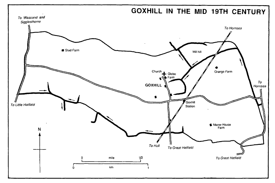
Goxhill in the mid 19th century
MANOR AND OTHER ESTATES.
In 1066 Morkar had c. 3 carucates at Goxhill and 1½ carucate in 'Arnestorp' as soke of his manor of Mappleton. All the land had passed to Drew de Bevrère by 1086 (fn. 16) and was later part of the Aumale fee.
Robert of Goxhill (d. by 1287) held in GOXHILL 2 carucates and 3 bovates in demesne and his tenants occupied a further 3 carucates and 5 bovates. (fn. 17) The manor later passed, together with the advowson, to the Lelley and Stokes families. By 1289 it may have belonged to Ralph Lelley, who then presented to the church, and Goxhill evidently descended to his widow Gillian, who was named as lord in 1316. (fn. 18) The manor, comprising 3½ carucates in the early 14th century and held as 1/12 knight's fee, later descended from father to son, being held by Ralph Lelley (d. by 1325), Robert Lelley (d. by 1339), Thomas Lelley (probably d. by 1369), and Ralph Lelley (d. by 1412). (fn. 19) That Ralph's widow Agnes presumably held the manor, presenting to the church in 1423 and again in 1452, but by 1488 the patronage and evidently also the manor had passed to Robert Stokes (d. 1506). He or another Robert Stokes was succeeded in Goxhill by a daughter Elizabeth (d. 1561), wife of Marmaduke Constable of Wassand and later of one Ashburne. In the 16th century the manor apparently extended into Great and Little Hatfield, and it may also have had appurtenances in Sigglesthorne, which would explain the references to Goxhill as part of the liberty of St. John's, Beverley. (fn. 20) It later descended with Wassand in the Constables and StricklandConstables. The Revd. Charles Constable had 792 a. in the parish c. 1840. (fn. 21) The estate was enlarged in 1914 by the purchase of c. 40 a. of glebe land, and in 1992 it belonged to Lady (Ernestine) Strickland-Constable. (fn. 22)
Meaux abbey was given 4 bovates in Goxhill by Peter Tuschett and a close there by another donor c. 1200 but the land was alienated before the mid 13th century. (fn. 23) William Mayne gave Nunkeeling priory a rent in Goxhill in 1498. (fn. 24)
ECONOMIC HISTORY
Open fields probably lay on the east and west sides of Goxhill village: a close named Little East field was recorded in 1716, and in 1992 ridge and furrow survived west of the settlement. Rough grazing probably bordered the main drain in the north-east corner of the parish, where Southorpe pasture was mentioned in 1716. (fn. 25) The commonable lands were evidently inclosed between 1650, when there were 2 bovates of glebe land, and 1685, when the rector had 36 a. instead; the rest of the land inclosed was presumably allotted to the Constable family. (fn. 26) Inclosure had perhaps taken place by 1663, when c. 150 a. at the west end of the parish lay in four adjoining closes which had apparently been landscaped with trees, probably by the Constables. (fn. 27)
In 1801 the area returned as under crops in the parish was 173 a. (fn. 28) There were 573 a. of arable land and 243 a. of grassland in 1839, and 467 a. and 223 a. respectively in 1905. (fn. 29) The proportion of arable to grassland was much the same in the 1930s, when the grassland mostly lay around the settlement and the outlying farms. (fn. 30) The parish also included 9 a. of woodland in 1905, (fn. 31) and several small plantations remained in 1992.
In the 19th and early 20th century there were half a dozen farmers, most of whom had 150 a. or more. A cowkeeper was also recorded from c. 1900. (fn. 32)
MILL Mill hill was presumably the site of the windmill recorded in 1325. (fn. 33)
LOCAL GOVERNMENT
Regular poor relief was given to two people in 1802-3 and to half a dozen a year in 1812-15; one person was aided occasionally in the earlier year and five a year in 1812-15. (fn. 34) Goxhill joined Skirlaugh poor-law union in 1837. (fn. 35) It remained in Skirlaugh rural district until 1935, and then, as part of Hatfield civil parish, in Holderness rural district until 1974, when it became part of the Holderness district of Humberside. (fn. 36) In 1996 Hatfield parish became part of a new East Riding unitary area. (fn. 37)
CHURCH
A church existed at Goxhill by the early 13th century, when a rector was recorded. (fn. 38) The rectory and Hornsea vicarage were united and the two parishes made one in 1939, but in 1972 that union was dissolved and the former parish of Goxhill was annexed instead to Mappleton, thenceforward known as the benefice and parish of Mappleton with Goxhill. (fn. 39)
The advowson descended with the manor in the Lelley, Stokes, and Constable families until the later 17th century, when it passed to the Listers. (fn. 40) In 1758 William Lister sold the patronage to Thomas Wakefield, then rector, from whom Marmaduke Constable bought it in 1774. (fn. 41) It then again descended with the manor until 1901, when Henry Strickland-Constable exchanged the advowon of Goxhill with the Crown. The Crown, which also had the presentation of Hornsea, became the patron of the united benefice in 1939. (fn. 42)
The rectory was worth £5 in 1291 and £9 8s. 6d. gross in 1535. (fn. 43) The improved annual value was £42 16s. 6d. net in 1650. (fn. 44) The net income averaged £284 a year in 1829-31 and in 1883 was £200. (fn. 45) Tithes were worth over £7 in 1535 and £30 gross in 1650. They were commuted for a rent charge of £183 13s. in 1839. (fn. 46) Glebe land included 2 bovates until 36 a. were evidently substituted for them between 1650 and 1685. (fn. 47) In 1914 the glebe, then of c. 40 a., was sold to Charles Strickland-Constable. (fn. 48)
The parsonage house, recorded from 1535, was rebuilt on the same site c. 1745. (fn. 49) It was evidently unused by incumbents and c. 1830 was returned as 'not fit'. (fn. 50) There was erroneously said to be no parsonage house in 1884, when it was let as the glebe farmhouse, together with another cottage; both houses were sold with the glebe in 1914. (fn. 51)
The church had a chantry dedicated to St. Mary and founded in 1389 by John of Goxhill, a former rector. Its patronage belonged to the rector in 1425, when the last known chaplain was presented. (fn. 52)
There is no evidence for rectors living at Goxhill in recent centuries. For much of the 18th century the rector, or in 1764, when he lived at Rowley, his curate, served Goxhill with Mappleton and Withernwick and lived at Great Hatfield. In the mid century a service was held at Goxhill on alternate Sundays and communion was administered there four times a year with 15 recipients in 1743 and 14 in 1764. (fn. 53) A curate was employed once more c. 1830. (fn. 54) In the 1860s, when the incumbent again also served Mappleton, service was weekly but communion was still only quarterly and there were no more than 8 communicants. (fn. 55) Goxhill was served alone c. 1880, when two weekly services and monthly communions were provided, but later the church was again held in plurality, with Hornsea, until the union of 1939, services being provided by the rector and an assistant curate. (fn. 56) The church was used only occasionally for services in 1992. (fn. 57)
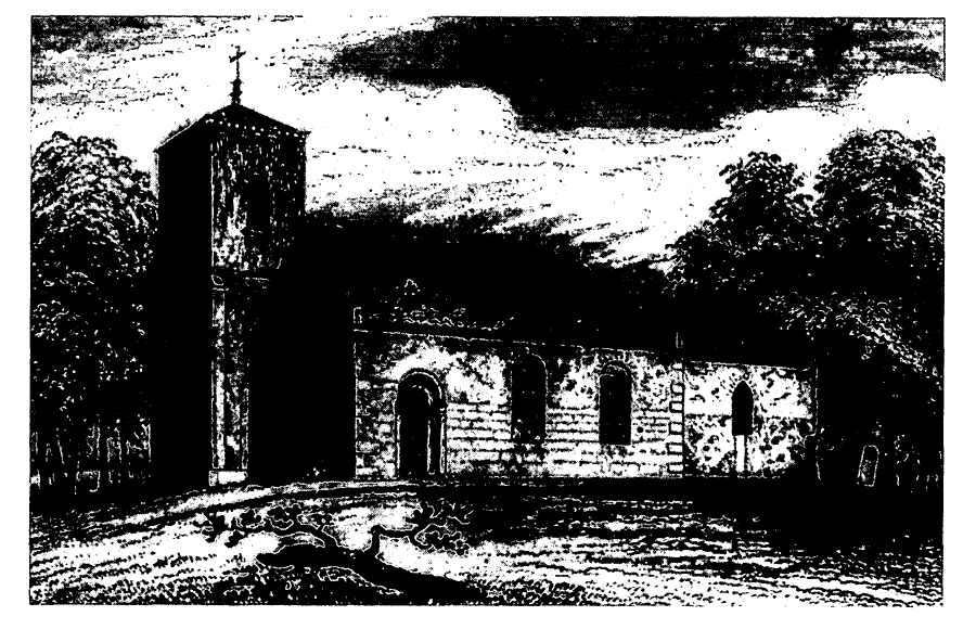
Goxhill Church c. 1830
The church of ST. GILES, so called in 1412, was in disrepair by the early 18th century and was largely rebuilt in 1786 at the expense of Marmaduke Constable. (fn. 58) The tower was replaced in 1817, and in 1840 the Revd. Charles Constable paid for the rest of the church to be rebuilt once again. (fn. 59) The church comprises chancel with pentagonal apse, nave, and west tower, and is in a plain, Gothick style. (fn. 60) It is built of boulders and brick, but the south sides of the chancel and nave have been faced with stone and the rest of the building rendered. The slate roofs are prominent and have deep eaves. Inside, the nave roof is borne by beams with large, pendant bosses, and the fittings include 19th-century oil lamps.
Burial at Goxhill ceased in the 1940s. (fn. 61) Memorials inside the church include a late medieval, carved floor-stone to Joan Lelley in the chancel, a floor-stone to Marmaduke Constable (d. 1690) in the nave, and a wall tablet to the Constables of Wassand. A restored 12th-century tub font, found at Hornsea, (fn. 62) and the stonework of a 15th-century piscina incorporating arms, apparently of the Lelley family, (fn. 63) are also preserved in the church. The modern font was removed to West Newton chapel-of-ease, in Aldbrough, in 1939. (fn. 64) There were two bells in 1552 but later only one. (fn. 65) The plate includes two cups, one of 1827, and a paten of 1830. (fn. 66) The registers of baptisms, marriages, and burials date from 1561 and are complete. (fn. 67)
NONCONFORMITY
A protestant dissenter was recorded at Goxhill in 1676, (fn. 68) but no other evidence of nonconformity has been found.
EDUCATION
The children of Goxhill have gone to school at Sigglesthorne, Hornsea, and Great Hatfield in the 19th and 20th centuries. (fn. 69)
CHARITIES FOR THE POOR
None known.