A History of the County of Wiltshire: Volume 17, Calne. Originally published by Victoria County History, London, 2002.
This free content was digitised by double rekeying. All rights reserved.
'Calne: The town to c.1800', in A History of the County of Wiltshire: Volume 17, Calne, (London, 2002) pp. 34-41. British History Online https://www.british-history.ac.uk/vch/wilts/vol17/pp34-41 [accessed 26 April 2024]
The town to c. 1800
Calne stands on the Marden where, 250 m. apart, there is an elevated site on each bank. In the early Middle Ages it was the principal settlement on a large royal estate, (fn. 1) and the elevated site on the right bank may then have been that of an important secular building. (fn. 2) That on the left bank is the site of Calne church.
An author writing c. 1000 possibly implied that in the 9th century the king had a house at Calne occupied by one of his officers, (fn. 3) and the witan met at the king's house there in 978 and 997. Unusually for the time the building in which the witan met in 978 incorporated a hall on an upper floor. The witan, which was attended by St. Dunstan, archbishop of Canterbury, met on the upper floor, and some of those attending were killed when the floor collapsed. (fn. 4) The 9th-century building, if it existed, and the house in which the witan met, whether the same or different, may have stood on the elevated site on the right bank of the Marden. In the mid 16th century land, known from 18thcentury evidence to lie near the site, was called Castle field, (fn. 5) and in 1621 a house presumably on the site was called the Castle and was approached from the town by Castle Street. (fn. 6) Castle House, said by John Aubrey in the later 17th century to be on the site of a castle, (fn. 7) was built on the site probably in the mid 17th century. (fn. 8) Although an important building may have occupied the site before the Conquest, there is no reference to one there later in the Middle Ages or to one as being fortified. In the 19th century an antiquarian thought, almost certainly wrongly, that two statements, that in 1139 the Empress Maud passed through Calne on her way to Bristol, and that in the same year King Stephen attacked a castle between Wallingford (Berks., later Oxon.) and Trowbridge, suggested that a castle stood at Calne: (fn. 9) the castle attacked by Stephen was probably at South Cerney (Glos.). (fn. 10)
In 1086 Calne may already have been, as it was later, a market town on the main London- Bristol road. (fn. 11) The church in it was well endowed, 74 or more tenements in it were held by burghal tenure, and the lordship of its lands stood divided between the king, of whom 45 of the burgesses were tenants, and the church. (fn. 12) The division seems to have determined the topography of the town. In the Middle Ages the king's successor as the lord of Calne manor and, as owner of the church's revenues, the treasurer of Salisbury cathedral each had the right to hold a market and a fair in the town, (fn. 13) and there were apparently two triangular market places or fair grounds. The north-west triangle, that on the right bank of the Marden and presumably for the lord of Calne manor's market, was apparently bounded by what became the east side of High Street, the south side of what in 1828 was called Cox's Hill, and the west side of what in 1828 was called Hog Street. The south-east triangle, that on the left bank and presumably for the treasurer's fair, was later called the Green or Kingsbury Green and was bounded on the west by the west side of the streets in 1828 called Church Street and Back Street. A market house was built near the apex of the north-west triangle; the church and a church house stood at the apex of the south-east triangle. (fn. 14)
The pattern of streets in Calne in the Middle Ages had almost certainly changed little by the mid 18th century, when buildings stood on the sides of and within the triangles, in streets leading off from the corners of the triangles, and on the London-Bristol road north-west and southeast of the triangles. There may have been two routes through the town for travellers on the London-Bristol road. One presumably passed through both triangles, crossing the Marden between them. (fn. 15) There was probably a bridge at the crossing in the Middle Ages, the bridge there in the 16th century was called Port bridge, (fn. 16) and the Town or Port mill stood a short distance south of the bridge; the course of the road over the bridge, between the southeast corner of the north-west triangle and the north corner of the south-east triangle, was called Butcher Row in the earlier 19th century. (fn. 17) The other route for London-Bristol travellers may have been on a road which crossed the Marden via a ford called Patford or Padford and avoided the south-east triangle and Butcher Row. A ford was apparently in use in 1491, (fn. 18) a bridge had been built by 1656, (fn. 19) and in the mid 18th century north of the bridge the road was called Patford Street and south of it Patford Lane. (fn. 20)
There was a serious fire in the town c. 1340. (fn. 21) Of the buildings erected before c. 1800 the earliest were presumably timber-framed. Houses of the 17th and 18th centuries have external walls of stone and timber-framed walls inside. Most of the stone is limestone rubble, laid with ashlar dressings in houses of higher quality; the walls of many houses were rendered. Until the 19th century quarries beside the London road north-west and south-east of the town were apparently the main sources of stone for building. (fn. 22)
The north-west triangle may have remained an open space until the late 17th century. By 1728 (fn. 23) much of it had been built on, the market place reduced to the north part, and, as High Street, the London road restricted to the east side. About the middle of the triangle and near the north-west side a three-storeyed house (no. 3 Market Hill) was built on a square, triplepile, plan in the late 17th century; it has a leaded platform in the centre of a hipped roof and bears a moveable sundial dated 1683. Its principal outbuilding, standing in 1828 (fn. 24) and 1999, was U-shaped, open on the west to Hog Street, and apparently built in the mid 18th century as stables. A house was also built in the south-east corner of the triangle in the late 17th century, and between the two houses other buildings were erected before 1728 to form a built-up rectangle in the south part of the triangle. The largest of all the buildings was the Catherine Wheel inn (in 1999 the Lansdowne Strand Hotel) which was built or rebuilt in the early 18th century, perhaps when the London- Bristol road was turnpiked. In 1999 the late 17th-century house in the south-east corner of the triangle was the oldest part of it. (fn. 25) North of the inn and east of the house dated 1683 a low two-storeyed house (adjoining no. 1 Market Hill) was built in the early 18th century and survived in 1999; a building standing west of it in 1728 was replaced by no. 2 Market Hill, a house built in the later 18th century. Two other buildings standing in 1728 were replaced in the 19th and 20th centuries. In the north part of the triangle a market house was built, probably for the first time, in the late 17th century or early 18th. (fn. 26) It was standing in 1728.
Each side of the north-west triangle had been lined with houses by 1728, (fn. 27) and on all sides houses built before c. 1800 survived in 1999. On the east side of High Street three houses (nos. 8, 9, and 12) were built c. 1700. Two of them have been refaced, and no. 13 may also predate its 19th-century front. On the northwest side of the triangle no. 4 Market Hill (formerly the Bell) (fn. 28) was built in the late 17th century as a three-storeyed house. About 1705, the date on a downpipe, a five-bayed, twostoreyed, symmetrical front range with rusticated quoins and an elaborate cornice was added and the house was refitted. In the 19th or 20th century a 17th-century building behind it, (fn. 29) probably of one storey and a half, was incorporated in the house. The west side of what was called Hog Street consists of a row of six attached houses, of which three (nos. 4, 12, and 16 Castle Street) were built before c. 1800. Each is of two storeys with attics and cellars. Nos. 12 and 16 (Benedict House) were altered in the earlier 19th century and later. No. 4 has a well detailed mid 18th-century faôade. On the south side of what was Cox's Hill no. 5 Castle Street was built in the earlier 18th century and altered in the 19th century.
The street leading north from the north corner of the market place had been given the name Wood Street by the early 17th century. (fn. 30) A nonconformist meeting house was built in it in the later 17th century, (fn. 31) and in the 18th century the street or part of it was called the World's End. (fn. 32) From Wood Street a road called Horse Lane in the 18th century, North Street from the 19th, led northwards. A road called Frog Lane in 1763-4 led eastwards; as part of the Wootton Bassett road turnpiked in 1791 it was later called Oxford Street and Oxford Road. (fn. 33) The Calne hundred pound stood in Wood Street in the early 17th century, in Oxford Road in the early 19th. (fn. 34) In the later 18th century there were buildings on both sides of Wood Street and for short distances along the other two roads. (fn. 35) The only ones built before c. 1800 that were recognizable in 1999 were four small houses or cottages on the east side of North Street (nos. 6, 10, 12, and 14) built in the earlier or mid 18th century, and possibly themuch altered building on the corner of WoodStreet and Oxford Road.
Castle Street leads from the west corner ofthe north-west triangle and in the 18th century had buildings along both its sides. (fn. 36) CastleHouse, on the south side, (fn. 37) was built in the 17thcentury, probably in the mid 17th century forWalter Norborne (d. 1659), and in the 1660swas lived in by his relict. In the 18th century itstood on an L plan with an east-west north range and an east range in which there was a hall. The north range, which stood parallel to Castle Street, had four bays, each of which had mullioned and transomed windows on the first floor and three-light mullioned windows on the second. A gable over each of the bays had been removed by the mid 20th century, and a fine stone chimneypiece of artisan mannerist character has been moved from the house to no. 3 Market Hill. In 1770-1 an east-west south range was added for Daniel Bull to designs by Robert Adam to give Castle House a U plan. The range is ashlar-faced, of two storeys, and plain except for a fluted frieze; the symmetrical seven-bayed south front has a central fullheight bow. By the mid 20th century a classical cornice to match that on the new range had been added to the north range. (fn. 38) In 1961 the house was bought by Calne borough council and converted to flats. Its older part was damaged by fire in 1967, demolished in 1974, and replaced by a block of flats for old people. (fn. 39) The whole building, which retains the exterior walls of the 18th-century range, was renovated in 2000. On the south side of Castle Street a pair of later 18th-century gate piers stands at what until the later 20th century was the entrance to the main drive of Castle House, and on the north side a pair of similar gate piers stands at the entrance to the yard of what was its coach house and stables. The coach house and stables standing in the earlier 19th century has been converted to a dwelling house (no. 22 Castle Street). (fn. 40) In the later 18th century formal gardens lay south of Castle House. (fn. 41) Of the other houses standing in Castle Street c. 1800 only three (nos. 18, 20, and 26) survive. (fn. 42) Each stands on the north side and appears to be 18th-century. A nonconformist chapel was built near the back of Castle House probably in the late 17th century. (fn. 43)
On the south-east triangle, as on the northwest, buildings had been erected by the 17th century. The north-east boundary of the triangle may have been the line from which the ground falls steeply to the Marden, a line followed by the north-east boundary of the churchyard, and the south boundary of the triangle may have been a field. Before and in the 17th century buildings were erected inside those boundaries on those sides of the triangle, and directly south of the church. (fn. 44) That course of the London road which passed through the triangle was restricted to its western edge. West of the churchyard it was called Church Street; further south it was called Rotten Row in the 18th century and Back Street in the19th. (fn. 45) In the late 19th century the name Church Street was applied also to the south part of the road, and the name Back Street went out of use. (fn. 46)
At the apex of the triangle a church house had been built outside and adjoining the north boundary of the churchyard by the mid 16th century. (fn. 47) Until 1829 the burgesses met in it and it was often called the guildhall; it was evidently not of two full storeys and part of it was a cottage lived in by the sexton. In the 1860s the building, which is of limestone rubble with ashlar dressings, was rebuilt, some of the walling being re-used, and was given a first-floor hall. (fn. 48) It was a church house in 1999. Of two houses standing immediately north of it one (no. 26 Church Street) is 17th-century and on an L plan and incorporates a 19th-century shop front.
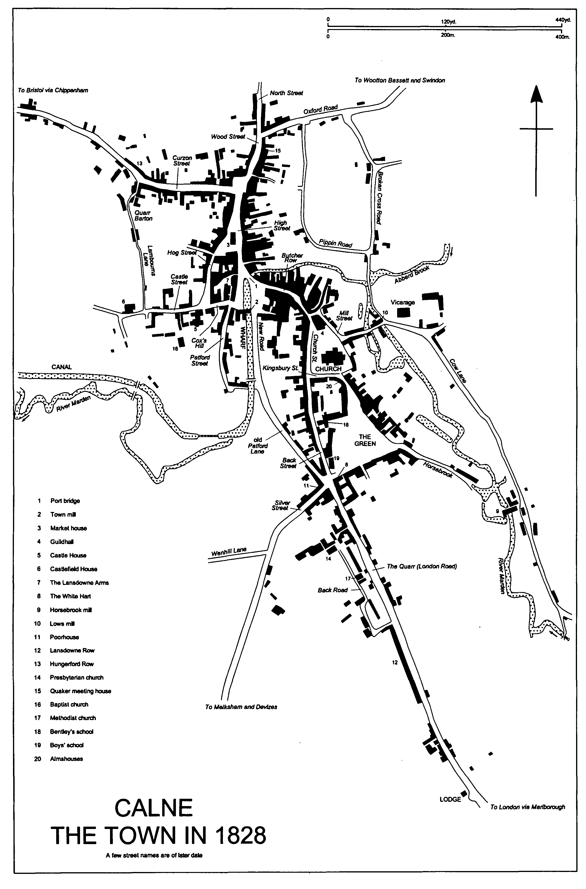
Calne the Town in 1828
On the west edge of the triangle c. 1800 buildings stood in an unbroken line along the west side of what was then Church Street and Back Street. There were then c. 30 houses, (fn. 49) of which c. 12 are known to have survived in 1999, the others apparently having been replaced in the 19th century. In 1999 the building of earliest origin was apparently a house of two storeys and attics, nos. 21 and 23, then a shop and flats, which incorporated two bays of a two-storeyed timber-framed house of c. 1500 or earlier. (fn. 50) No. 41 is a two-storeyed later 17th-century house with five-light, ovolo-moulded, mullioned and transomed windows in a projecting canted bay, and no. 19, formerly the Butchers Arms, retains a 17th-century wing behind an early 19th-century front. (fn. 51) No. 44 is a three-bayed house of the 18th century, and the other survivors from c. 1800 are small 18th-century houses.
Within the triangle on its north-east side houses were built from the 15th century or earlier. Along that side in the 18th century there were c. 10 houses, of which those at the north-west end stood in a continuous row. About the middle a timber-framed open-hall house was built in the mid 15th century; by 1828 it had been divided into two houses (nos. 6 and 7 the Green), encased in limestone rubble, extended, and otherwise altered. (fn. 52) South-east of nos. 6 and 7 three houses may be of 17th- or early 18th-century origin. Adam House (no. 13) has a 17th-century rear wing and a front range of c. 1750 with a Palladian five-bayed faôade. Sheldon House (no. 10) has a mid 18th-century five-bayed stuccoed front, and no. 12 has an early 19th-century front faced in lined-out stucco. (fn. 53)
Within the triangle on its south side houses were built from the 16th century or earlier. To judge from the regular shape, and almost equal size, of the plots the encroachment may have been planned. (fn. 54) In the later 18th century a row of 8-10 houses stood there, (fn. 55) and at the west end four of the houses survive. Although much altered since, the White Hart at the south-west corner of the Green and nos. 19 (Priestley House) and 20 the Green were apparently erected as one building in the 16th century and share a basement. Priestley House and no. 20 were rebuilt mainly in the 17th century and were refronted in the mid 18th. The façade of Priestley House is dated 1758. (fn. 56) No. 18, immediately east of Priestley House, was built in the 17th or 18th century and refronted in the 19th, and further east no. 15 is a three-storeyed house possibly built in the 18th century.
Directly south of the church and near the west edge of the triangle a house was standing in 1663; in 1665 it was said to have been newly built. The house, in which Bentley's school was held from c. 1664, was apparently large, and a large and roughly square plot extending northeastwards from it almost to the churchyard was probably its garden. From the late 17th century buildings were erected along all four edges of the plot, and by the 18th century c. 20 houses stood there. Near the church a curved terrace of eight almshouses, each of two low storeys, was built in the late 17th century along the northeast edge and apparently within the plot, the convex curve apparently following the boundary. (fn. 57) Probably also in the late 17th century a house was built on each of the north, east, and west edges of the plot. On the north no. 1 Kingsbury Street, a house of two storeys and attics, was extended in the 18th century; (fn. 58) on the east no. 33 the Green, a house probably of a single storey or a storey and a half, was raised to two storeys c. 1700; on the west no. 32 Church Street, a two-storeyed house, was refronted in dressed limestone, and given a Doric porch, in the 19th century. Three 18th-century houses stand on the plot, on the south nos. 28 and 29 the Green, no. 29 having been converted from an outbuilding or workshop, (fn. 59) and on the west no. 36 Church Street, which incorporated a shop in 1999. Bentley's school was rebuilt in the 19th century. (fn. 60)
Directly south of Bentley's school a north- south line of buildings had been erected by th earlier 18th century. (fn. 61) One of the buildings was a house (no. 23 the Green) built on an L plan in the 17th century; it was refronted in the early or mid 19th century and survived in 1999. The other buildings were replaced in the 19th century.
From the apex of the south-east triangle Mill Street leads south-east and east to the mill and the demesne farmstead at the south end of Eastman Street. (fn. 62) In the east-west part of Mill Street terraces of cottages were built between the mill and the church. On the north side nos. 4-7 are apparently 18th-century, no. 6 having been converted in the 19th century from a small factory. (fn. 63) On the south side a row of seven attached cottages consists of one (no. 21) of two storeys and attics built in the late 17th century, five built in the 18th century, and one (no. 19) rebuilt in the 19th century; attached to the rear of no. 19 is another late 17th-century cottage. (fn. 64)
From the east corner of the Green, Horsebrook leads south-east to another mill on the Marden. (fn. 65) By the earlier 19th century six small houses, five of which stood as a terrace, had been built halfway between the Green and the mill, and, where Horsebrook leaves the Green, about eight small houses had been built apparently on the waste or in the garden of the end house on the south side of the Green. (fn. 66) None of those houses in Horsebrook survives, those to the south-east having been replaced in the 20th century. An industrial building erected c. 1800 on the north-east side of Horsebrook where it leaves the Green was a weavers' workshop in the earlier 19th century and was later converted to the house (no. 2 Horsebrook) called Maundrell House in 1999. (fn. 67)
From the south-west corner of the Green, Silver Street runs south-west and was part of the Melksham and Devizes road turnpiked in 1790. (fn. 68) In the mid 17th century a large house, later the parish workhouse, was built at the corner of Silver Street and Patford Lane (later New Road), (fn. 69) and in 1763-4 several buildings stood on each side of Silver Street. Another large house stood a short distance south-west of the workhouse, and in the earlier 1790s a cloth factory was built between and adjoining them. The factory, probably of five bays and with arched windows with stone mullions, was largely demolished in 1869 or soon after. A house standing in 1763-4 in the angle with the London road may have been the possibly 18thcentury house which was the nucleus of the house called South Place. (fn. 70) Except for the basement of the factory none of the buildings standing in Silver Street c. 1800 survived in 1999.
The alternative courses of the London road linking the two triangles were Butcher Row and, to the west, Patford Street and Patford Lane. (fn. 71) In the 18th century Butcher Row lay closely built up on both sides, c. 16 houses standing on the north side and c. 12 on the south. Joining High Street over Port bridge it was probably a commercially important part of the town. (fn. 72) At the west end on the south side a large and roughly square house was standing in 1763-4. It was possibly, or more likely was replaced by, the 18th-century house, twostoreyed, double-pile, and with four-bayed north-east and north-west faôades, which occupied the site, was used as a bank, (fn. 73) and was replaced in 1901. (fn. 74) All or nearly all the other buildings in Butcher Row were demolished in the 19th and 20th centuries when factories were built either side of the street; (fn. 75) the name Butcher Row went out of use, and in the later 19th century the street was considered part of Church Street. (fn. 76) On the north side of Butcher Row buildings adjoining the rear of no. 20 Church Street, a house rebuilt in the 19th century and incorporating a shop, may survive from the 18th century. About 1800 c. 14 cottages stood in a short lane leading north-east from the junction of Butcher Row and Mill Street; (fn. 77) none survives.
Patford Lane and Patford Street may have been less used by London-Bristol traffic than Butcher Row, and in the 18th century only Patford Street was built up; c. 5 houses stood on the west side, 4 of which survived in 1999, and perhaps c. 10 on the east side, (fn. 78) of which no more than one survived. On the west side Patford House, seven-bayed, two-storeyed, and stuccoed with limestone dressings, was built in the earlier or mid 18th century; c. 1800 it was refronted and given full-height bow windows and a pedimented doorcase with attached Tuscan columns. The house had a large garden beside the street south of it, and a small garden on the east side of the street. A service or industrial building adjoining the south end of the house was converted to a house in a style to match that of the new front, after 1828 (fn. 79) and presumably in the 19th century. North of Patford House nos. 4 and 5 Patford Street are 18th-century houses, and north of them a twostoreyed 17th-century house with two full-height shallow canted bays was converted to two houses (nos. 2 and 3 Patford Street) and restored to one in the 20th century. (fn. 80) On the east side of Patford Street a house (no. 7) possibly built in the 18th century has a 19th-century front.
The Bristol road leading west from the north end of the town was called Cosen Street in the 16th century, Cozen Street in the 17th century, (fn. 81) and Curzon Street later. By c. 1800 it had been built up for c. 200 m. from where it joined High Street. Some 30 houses may have stood there, more on the south side than the north, (fn. 82) and only three are known to survive. St. Cecilia's (no. 5), on the north side near the junction, was built in the early 18th century as a house of five bays and of two storeys and attics over a vaulted brick basement. It is the grandest of its period to survive in the town and has a south façade, faced in brick with stone dressings, in Baroque style. In the early 19th century a wing, one bay wide and projecting southwards, was added to the east, and a projection was added in front of the west bay to form a shallow U open to the street; both projections are in neoclassical style and faced in ashlar. Also in the early 19th century a staircase projection with a cantilevered stair was added at the centre of the north front; later in the 19th century it was embraced by a new north range, which has a north front faced in rubble and in Tudor style. A new entrance hall was made at the west end of the original south range, probably c. 1900; a new doorway was built to link it to the street, and the original doorcase was probably moved eastwards. In the mid 19th century the house, then called Northfield House, was a lunatic asylum, and from c. 1946 it was part of St. Mary's school. (fn. 83) On the south side of Curzon Street opposite St. Cecilia's there is another two-storeyed house (no. 6) which, improbably dated 1617, has a mid 18thcentury front range. The main façade has rusticated quoins and a swan-necked pediment over the door. West of St. Cecilia's on the north side of the street no. 15, which was altered in the 19th century, and west of no. 6 on the south side no. 8, which has a mid 19th-century front, may both be 18th-century in origin. (fn. 84)
The London road leading south-east from the town was called Quarry Street in the mid 18th century and the Quarr in the earlier 19th. In 1763-4 there were buildings along both sides of it for c. 500 m. from the south-west corner of the Green. Most of them were probably cottages or small workshops. (fn. 85) Five attached cottages in a row (odd nos. 63-71 London Road), set back from the south-west side of the road, are apparently 18th-century and probably the only buildings older than c. 1800 to survive.
On the edges of the town, houses and cottages stood c. 1800 off the London road on the south edge, on the east edge in Cow Lane (otherwise Kew Lane, sometime partly Eastmead Street, and in 1999 wholly Anchor Road), and on the west edge in and off the Bristol road. Most of the cottages stood in groups, (fn. 86) may have been built by squatters or for workers in quarries or mills, and may not have been of high quality. Although few of them survived in 1999 the sites of many of them had by then been re-used for building.
Cottages off the London road to the south, c. 1800 called Quarry Street or the Quarr, stood in a lane, south-west of and parallel to the road and later called Back Road, where a nonconformist chapel was built in the late 17th century. (fn. 87) In 1999 the only buildings in Back Road older than c. 1800 were two adjoining pairs of cottages (nos. 7-10) dating from the late 18th century.
In Cow Lane, which followed the Marden from the mill at the south end of Eastman Street to Kew Lane mill, (fn. 88) there were three groups of cottages c. 1800. A small group stood immediately south-east of the demesne farmstead at the south end of Eastman Street, a larger group stood near Horsebrook mill, and another small group stood near Kew Lane mill. None of the first group survives. Of the second, which was already a large group in 1728, (fn. 89) three may survive: no. 21 Anchor Road, which has a lobby-entrance plan, no. 90, and no. 96, which stands end-on to the road, are apparently 18thcentury cottages. Of the third group two survive: no. 112 Anchor Road is thatched, has a lobby-entrance plan, and bears the date 1733, and no. 108 is also 18th-century.
In the Bristol road on the west edge of the town what were apparently two farmsteads or business premises were standing in the mid 18th century; that to the west was called the Hermitage in the early 19th century. (fn. 90) Between them c. 1800 there were c. 15 houses or cottages. Of all those buildings no. 68 Curzon Street, a five-bayed house of two storeys and attics altered in the 19th century and possibly built in the 18th, may be the only survivor. Off the Bristol road cottages were built in a group, later called Quarr Barton, from the 17th century or earlier at the north end of a north-south lane linking the west ends of Curzon Street and Castle Street. The lane was called Lambourns Lane in 1828. (fn. 91) About 1800 probably c. 15 cottages stood at the north end and c. 4 cottages and several other buildings further south. Of those to the north two adjoining pairs, mostly 18th-century, and a house, converted to two cottages and possibly partly 17th-century, were standing in 1999. The site of the southern group was cleared in the 19th century. (fn. 92)
A hospital, in which St. John the Baptist and St. Anthony were invoked, stood in the town from 1248 or earlier. (fn. 93) In 1442 part of its endowment was transferred to a chantry in Heytesbury church, (fn. 94) in 1535 its net income, £2 2s. 8d., was low, (fn. 95) and in 1546 it was providing no accommodation for poor people. (fn. 96) The Crown sold the hospital and its remaining endowments in 1548. (fn. 97) In the earlier 14th century the hospital was approached by a road leading from Church Street and stood near a watercourse: (fn. 98) its site, which was not otherwise described, could have been in Mill Street, north-east of Butcher Row, or between Church Street and Patford Street.