A History of the County of Wiltshire: Volume 17, Calne. Originally published by Victoria County History, London, 2002.
This free content was digitised by double rekeying. All rights reserved.
'Bowood', in A History of the County of Wiltshire: Volume 17, Calne, (London, 2002) pp. 116-123. British History Online https://www.british-history.ac.uk/vch/wilts/vol17/pp116-123 [accessed 24 April 2024]
In this section
BOWOOD
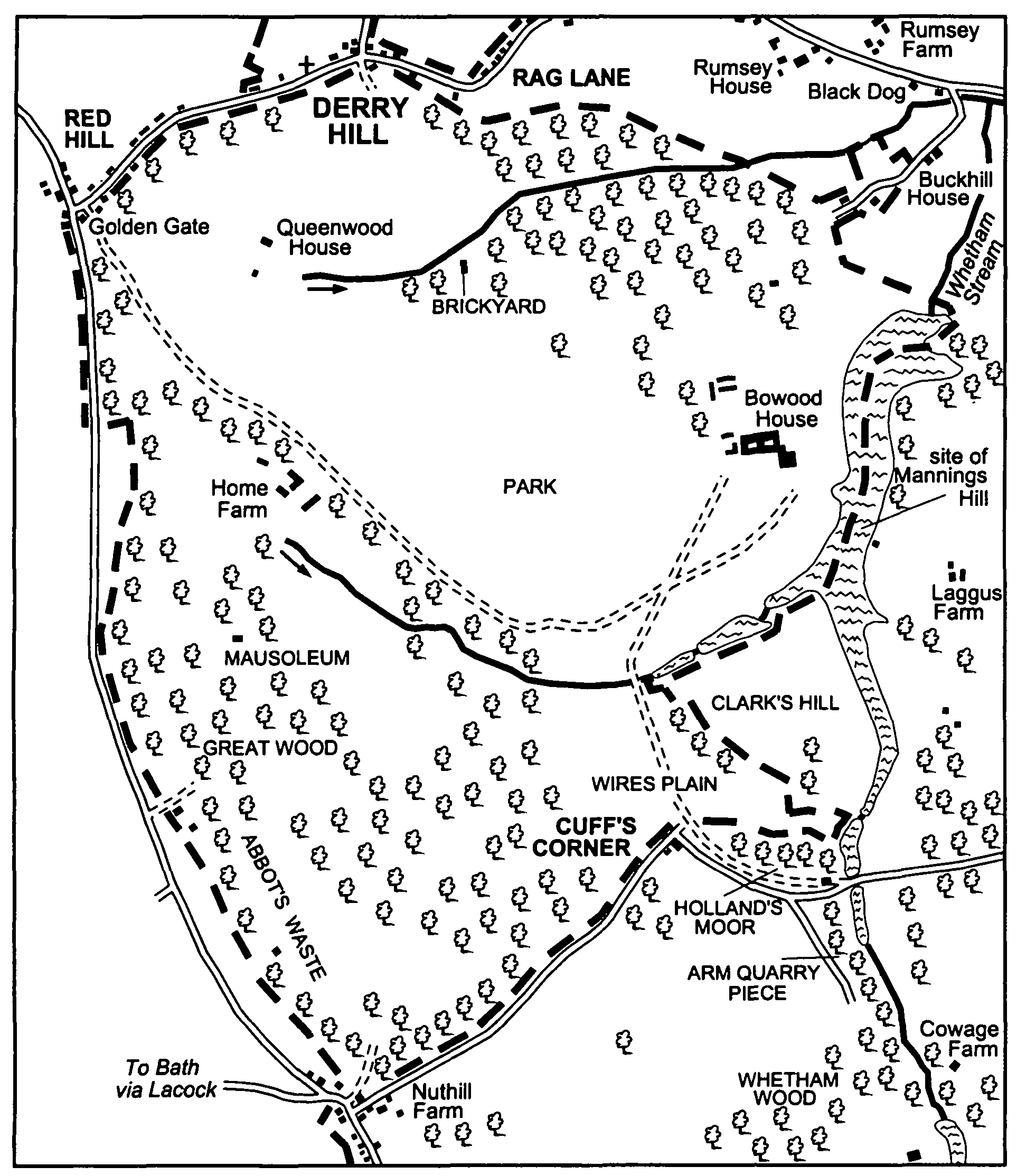
Bowood liberty consisted of land imparked c. 1618 and formerly part of Chippenham forest. (fn. 1) In 1709 the justices at quarter sessions found that the liberty included settlements on the edge of the park called Mannings Hill, Cuff's Corner, and Buck Hill, and part of the settlement called Red Hill; the settlements probably included many squatters' cottages. (fn. 2) In the earlier 19th century the boundary of the liberty was drawn to include Buck Hill and to exclude all or nearly all the site of each of the other three settlements. The liberty was then of 991 a. and consisted of only the park of Bowood House and Buck Hill. (fn. 3) In 1890 it became part of Calne Without parish. (fn. 4)
The population of Bowood liberty increased from 34 in 1811 to 81 in 1831 and from 68 in 1841 to 140 in 1851. Few new houses were built between 1841 and 1851 and much of the later increase was due to a rise in the number living in Bowood House. By 1881 the population of the liberty had decreased to 92. (fn. 5)
In the late 16th century and early 17th there were two or more houses on the west side of what became the liberty, (fn. 6) and in 1650 three lodges stood in the park. None of the lodges survives. One probably stood on or near the site of Bowood House, which was built probably c. 1727; one, described in 1650 as new, probably stood on the site of the farmstead called Home (formerly Lodge) Farm, which had been built west of Bowood House by 1754; the third apparently stood south-west of the site of Bowood House. There were three other farmsteads in the park in 1754; one, north of Home Farm on the site of Queenwood House, possibly stood on the site of a barn standing in 1650. (fn. 7) The farmhouse of Home Farm, of dressed rubble with plain mullioned windows, has a south-west range with arched cellars and probably of the mid 18th century, and a main north-east range of the 19th century. (fn. 8) South-east of it there was a barn, of stone rubble with a stone-slated roof and probably late 18th- or early 19th-century, and north-west of it there was a slightly smaller stone barn. In 1992 the south-east barn was linked to the house, other farm buildings were removed or demolished, and Home Farm became the club house of a golf course. In 1998 new ranges in a rustic style were built to link the house and the north-west barn, and other buildings were erected. (fn. 9) Queenwood House, also of dressed rubble and incorporating tall decorated chimney shafts, was built in the earlier 19th century as a large cottage ornée. On the site of a third farmstead standing in 1754 the Osprey, an estate yard with singlestoreyed stone buildings and a two-storeyed red-brick house around it, was built between 1847 and 1885. It remained an estate yard in 2000. The fourth farmstead, Litton's Farm, was on the site north-west of Home Farm on which a row of cottages called Home Farm Cottages stood in the 19th century; the cottages were demolished in 1992. Several of the lodges built at the entrances to Bowood park, and a few cottages at Derry Hill and Sandy Lane, also stood in the liberty. Between Bowood House and Queenwood House a brickyard was in use in 1806; it was removed between 1885 and 1899. (fn. 10)
Bowood in 1843: from the map on page 28
Bowood liberty had a small north-eastern protrusion taking in Buck Hill. A cottage of dressed stone and a school with mullioned windows and carved bargeboards were built there in the earlier 19th century. (fn. 11) Both buildings were standing in 2000.
ESTATES
What became Bowood liberty belonged to the Crown in the Middle Ages as part of Chippenham forest. (fn. 12) About 1618 that part of the forest, including woodland accounted 404 a. or 496 a., was inclosed by the king as BOWOOD park, which was apparently roughly conterminous with the later liberty. (fn. 13) Within the new park lay lands formerly assarted from the forest, with the owners of which the king compounded. The largest assart was apparently that assessed at 82 a. in the north-west part of the park for which the king had compounded with Mervyn Tuchet, earl of Castlehaven, by 1619. (fn. 14) It was later claimed successfully that the king had inclosed Abbot's Waste, c. 50 a. in the south corner of the park, without compounding with the tenant in demesne. (fn. 15)
Bowood park was retained by the Crown until 1727, when it was bought by the tenant, Sir Orlando Bridgeman, Bt. (d. 1738 or 1745), who had a son Francis (d. s.p. 1740). Under a Chancery decree of 1739 the park and Bowood House, which Sir Orlando had built on it, were acquired by Richard Long, Sir Orlando's principal creditor, who sold them in 1754 to John Petty, earl of Shelburne (d. 1761). Petty devised them to his wife Mary, who in 1761 or 1762 conveyed them to her son William Petty, earl of Shelburne (cr. marquess of Lansdowne 1784, d. 1805). (fn. 16) Bowood House and its park passed in turn to William's sons John, marquess of Lansdowne (d. 1809), and Henry, marquess of Lansdowne (d. 1863), who in 1818 adopted the surname Petty-Fitzmaurice and in 1845 owned the whole liberty. (fn. 17) From 1863 the house and park descended with the marquessate in the direct line to Henry (d. 1866), Henry (d. 1927), Henry (d. 1936), and Charles (d. 1944). Charles's heir was his cousin George Mercer Nairne (from 1947 George Mercer Nairne Petty-Fitzmaurice), marquess of Lansdowne (d. 1999). In 1999 Bowood House and park belonged to George's son Charles PettyFitzmaurice, marquess of Lansdowne, and trustees of his family. (fn. 18)
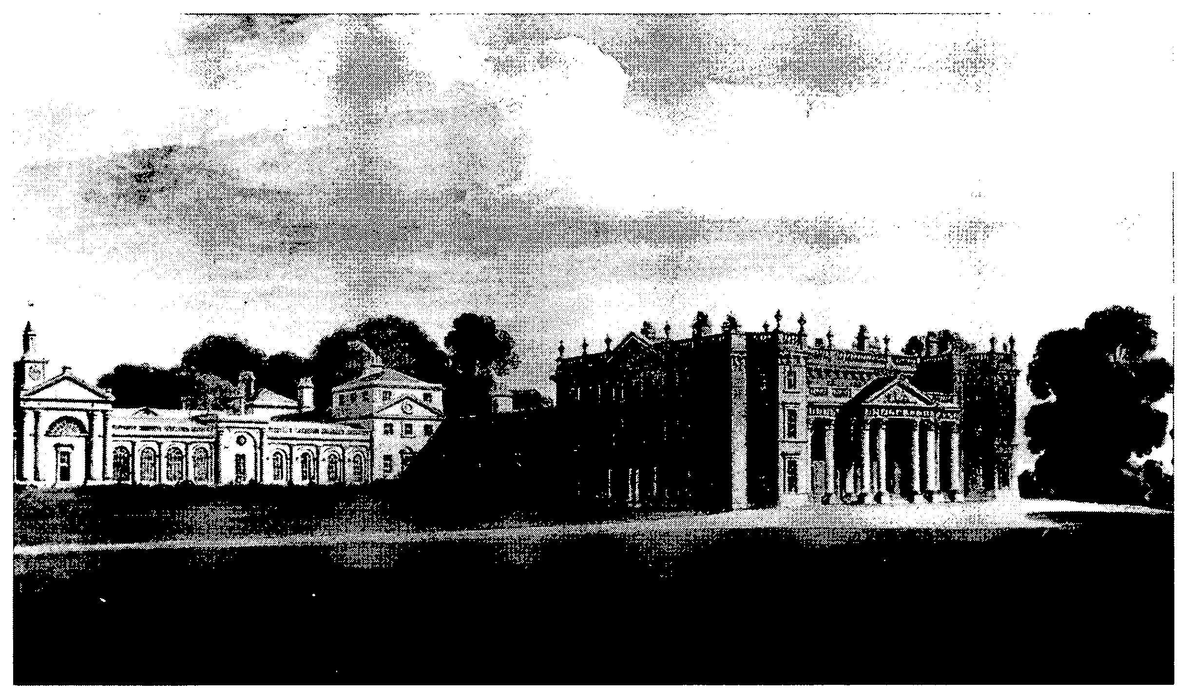
Bowood House was built by Sir Orlando Bridgeman probably c. 1727, the year in which he bought the inheritance in fee of the park. (fn. 19) It was probably built on or near the site of, and presumably replaced, Lower Lodge, a house which in 1650 stood in the park and was described as old. (fn. 20) Bowood House, apparently built of rendered stone, was of two storeys and a half and had a basement. Its main front, to the south, was plain: it incorporated tall sashed windows, a central pedimented doorcase, and parapets which hid the roof. East and west wings, both two bays wide, projected south by one bay and flanked a centre of seven bays; only one of the wings projected northwards. The basement lay under the seven central bays, probably extended under the east wing, and possibly extended under the west wing. To the north-west, lying east-west along the north boundary of the walled ground surrounding the house, there was an apparently contemporary building of two storeys and attics. It consisted of a pedimented coach house with to the east seven and to the west eight bays of stables and service rooms. (fn. 21)
When John, earl of Shelburne, bought Bowood House in 1754 it may already have appeared old fashioned, and some interior fittings, including a grand staircase, were incomplete. Lord Shelburne engaged the architect Henry Keene, who directed work on the house until 1761, the year in which Lord Shelburne died. By 1755 the second of the wings had been extended northwards and the house thus given an H plan. The elevations were altered in Baroque style, the most distinctive changes being the addition of a high balustraded parapet, of an octostyle Roman Doric portico, with two rows of columns and a pediment, in the central five bays of the south front, and of a full-height canted bay on the south front of each of the wings. The whole south front was faced in ashlar, probably when the canted bays and the portico were built; the other fronts apparently remained rendered. North-west of the house the service range was demolished and a new one built of dressed stone in Palladian style. The new building, almost three times as long as the south front of the house, had an E plan with the open courts to the south; three-storeyed towers with pyramid roofs stood at its north-east and north-west corners and terminated the east and west wings to the south. The south elevation of the central wing had a tall niche and a columned cupola; all the elevations facing the courts had pilasters between arch-headed openings on the ground floor. Service rooms were ranged around the east court, stables and coach houses around the west. The kitchen was moved from the main house to a vaulted basement at the south end of the east wing of the service building and was linked to the house by a tunnel. (fn. 22)
Between 1761 and 1770 work on Bowood House was carried out to designs by Robert Adam. Between 1761 and 1763 the portico was altered and a porch was built on the west front. A drawing room and a room called the cube room had been built between the wings on the north front by 1763, probably to designs by Adam. Inside the house Adam altered the entrance hall and the north-east ground-floor rooms by raising their ceilings and apparently designed the east staircase. Between 1768 and 1770 two nine-bayed ranges were built between the south ends of the three wings of the service building, thus enclosing the courts; the long range consisting of the two new ranges and the ends of the three wings, altogether of 25 bays, was called the Diocletian wing, Adam, in designing its south front, having been inspired by features of Diocletian's palace at Spalato (Split, Croatia). (fn. 23) The south faôades of the east and west wings were retained, and Adam varied the rhythm of the whole composition by applying a pedimented portico to the south front of the central wing and by making each central bay of the new ranges taller than the others and giving them attached columns. The central nine bays of the Diocletian wing were occupied by a greenhouse (later called the Orangery) lit by full-length arched windows. The bays between the greenhouse and the south-east and southwest towers had smaller arched windows. On the east the windows lit a room used as a laboratory from the 1770s to the 1790s and a library; there was a supper room in the east tower. On the west there was a menagerie, the central bay was an open arch to the stable court, and the windows were false. The arch was closed when a garden terrace was laid out in 1818, and the windows were made genuine in 1980. (fn. 24)
Bowood House from the south-west in 1806
In the 1760s the accommodation of the main house was supplemented by the library, by the supper room, and by rooms in the east wing of the service building converted to living rooms. An octagonal staircase hall and an ante-room were built, almost certainly to Adam's design, as part of an apparently incomplete link between the east wing and the north-west corner of the main house; to complete the link a drawing room was built in 1775 under the direction of James White, formerly an assistant to Adam. (fn. 25) The main house was later called the Big House, the east wing the Little House.
In 1823, to designs by C. R. Cockerell, the four bays of the central wing of the service building adjoining the greenhouse were converted to a chapel, and Cockerell designed the redecoration of the library between 1821 and 1824; the painted medallions on the coffered ceiling of the library may have been added in 1842. Between 1830 and 1833 the west part of the Big House, and the supper room in the tower at the east end of the Diocletian wing which became an eastern extension of the library, were altered to designs by Charles Barry. An entrance hall, approached through the porch built between 1761 and 1763, was made in the Big House, and at its north end led to a new staircase hall built to replace the octagonal one; the staircase hall led in turn to a new gallery, built along its west side and along the west side of the ante-room built between 1768 and 1770 and of the drawing room built in 1775; the gallery opened directly into the old supper room and thus gave access between the Big House and the Diocletian wing without the need to enter the drawing room. A staircase was built in the angle of the Diocletian wing and the Little House to provide access between the kitchen and a dining room in the Little House; (fn. 26) it was demolished in 1955. (fn. 27) A wooden clock tower above the chapel, perhaps surviving from the 18th century, was replaced in 1860 by a stone one designed by Barry. (fn. 28)
In 1955 the Big House and the buildings linking it to the Little House and the Diocletian wing were demolished. To designs by F. Sortain Samuels, based on proposals made in 1947 by Philip Tilden, the Little House, which in 1955 contained private apartments, was converted to a self-contained house. It is entered by a new door from the east courtyard, and a central staircase in 18th-century style was constructed in it. Fittings from the Big House were re-used in it: they included the chimneypiece apparently designed by Adam for the drawing room, which was moved to the library. Other fittings from the Big House were re-used in the chapel; most were dispersed. The chapel and most of the Diocletian wing were opened to the public in 1975, and in the period 1978-80 the west wing of the old service building was converted to a restaurant, a shop, and exhibition rooms, the west end of the Diocletian wing to a sculpture gallery. (fn. 29)
The south front of the house built for Sir Orlando Bridgeman opened on to a raised terrace which lay within a rectangular walled forecourt. In the lower part of the forecourt lay a circle of pathway, and there was a gate in the centre of each side. The south gate stood in a curved projection of the forecourt. The east led to an area in which there was a raised terrace along the side of the house, a lawn below the terrace, and below that a rectangular pool fed by the Whetham stream; north and south of the pool the stream flowed through wooded areas with formal walks and serpentine paths. The west gate led to a long walled court bounded to the north by the service building. An avenue led north from the house. (fn. 30) By 1754 part of the avenue, and probably some of the formal features around the house, had been removed, and between 1754 and 1763 the walls of a large square kitchen garden were built north of the service building, and the garden was divided by walls into quarters. (fn. 31) The walls, of stone and brick, survived in 1999, when the north-west quarter contained greenhouses built c. 1900 and later (fn. 32) and the south-east quarter contained a tennis court and a swimming pool. In 1999 the buildings of a laundry court west of the service building were mainly 19th-century.
Bowood House was built in a park of c. 940 a. partly used for agriculture in 1754. (fn. 33) In 1762 William, earl of Shelburne, commissioned Lancelot Brown to alter the landscape around the house, and arable farming in the park ceased soon afterwards. Brown presented his designs in 1763, and by 1768 most of them had been executed. To extend the park eastwards and south-eastwards Lord Shelburne acquired land, mostly east of the Whetham stream, by purchase and exchange between 1765 and 1767. In 1766 the stream was dammed to make a long north-south lake east of the house, and south of the house a tributary formed a spur of the lake. North of the house an arboretum was begun within pleasure grounds bounded by a haha. In some places in the park the level of the ground was altered; west of the house field boundaries were removed, rides were disrupted, stands of trees were left, and the stands were supplemented by clumps planted on grassland. All but c. 75 a. of the woodland standing in the early 17th century had been removed by 1754. Under Brown's direction woodland protecting the north side of the house was kept, plantations in the west part of the park were extended, and a belt of trees was planted along the west part of the park's northern boundary to link the plantations to the woodland north of the house. Abbot's waste, in the south corner of the park, was bought by Lord Shelburne in 1769. A mausoleum for John, earl of Shelburne (d. 1761), was built in woodland on high ground in the west part of the park to designs by Robert Adam and was completed c. 1765. (fn. 34) It was designed in an austere Roman Doric style and stands on the plan of a Greek cross. Its centre is crowned by an hemispherical dome, and its arms are formed by a portico on the east side and lower projections on the other sides. (fn. 35) Its main part is a chapel, which houses a sarcophagus designed by Agostino Carlini, completed in the mid 1770s, and containing the remains of Lord Shelburne and his wife. (fn. 36) Beneath the chapel, and reached by a ramp on the west side of the building, is a vault containing 51 burial niches. (fn. 37) A Doric temple had been built north of the kitchen garden by 1778; (fn. 38) the designer is unknown, and the building was moved to the east side of the lake in 1864. (fn. 39) About 1785, under the direction of Josiah Lane of Tisbury, a rockwork cascade was built north of the dam at the north end of the lake, and a grotto was built east of it. (fn. 40) A rockwork cascade at the south end of the lake is of similar date. (fn. 41) On the west shore of the lake a half-timbered boathouse in a picturesque style was built apparently between 1847 and 1885. (fn. 42)
The immediate surroundings of Bowood House were transformed in the 19th century. In 1818 a formal garden terrace designed by Robert Smirke was laid out along the whole south front of the Diocletian wing; the terrace blocked basement windows at the east end of the wing, and the carriage arch towards the west end was closed. In 1851-3 a lower parallel terrace, adjoining the higher terrace and the west front of the Big House and with a small Italianate pavilion at its south-west corner, was made to designs by George Kennedy. (fn. 43) By 1857 Italianate gardens had been laid out on both terraces. (fn. 44) Yews were planted c. 1900, and both terraces were extended a little eastwards after the Big House and the linking buildings were demolished in 1955. The pavilion was destroyed by falling trees in 1990. (fn. 45) In the angle of the Big House and the Little House a garden terrace, extending along the whole east front of the Little House, was made in 1865-6, (fn. 46) and steps were built to link it to the east front of the drawing room built in 1775. (fn. 47) The three terraces survived in 1999. A forecourt made in front of the Big House in 1851-3 to designs by Kennedy and incorporating iron gates and recumbent lions (fn. 48) was destroyed with the house in 1955; the gates were re-used at the east and west ends of the yard between the service building and the walled kitchen garden, the lions on the terrace made in 1851-3.
North of the kitchen garden, near the arboretum, a pinetum, in which trees indigenous to the same parts of the world were grouped together, was planted in 1848-9. (fn. 49) In woodland near the mausoleum many rhododendrons were planted in the 1850s and after the Second World War. (fn. 50)
As inclosed c. 1618 Bowood park had seven gates, Mannings Hill and Cuff's on the southeast, Horselpride at the north end of Sandy Lane, Loxfield Heath between Sandy Lane and Derry Hill, Redhill (or Derry) at the west end of Derry Hill, Studley towards the east end of Derry Hill, and Buckhill on the north-east. (fn. 51) In the earlier 19th century lodges and other buildings were erected in picturesque styles at or near the entrances to the park, and in 1999 lodges stood at or near the sites of all but the first two of those early 17th-century gates. After the alterations made to the park in the 1760s the two main entrances became those at its northwest and south-east corners, each giving access to and from the London-Bristol road. (fn. 52) At and near the north-western entrance, that at the west end of Derry Hill, a stone cottage which may have been a lodge, and other stone cottages in a consistent picturesque style, were built in the earlier or mid 19th century, after a new course for the London road had been built away from the north boundary of the park. (fn. 53) A new gateway, the Golden Gate, consisting of a triumphal arch and belvedere, was built in Italianate style c. 1841 to designs by Charles Barry; (fn. 54) a lodge in similar style was added later. About 1766 the park was extended southeastwards, and the height of the dam across the Whetham stream was fixed to make the tail of the new lake lie at the new boundary. (fn. 55) The road from the north end of Sandy Lane to Calne was diverted to the new south edge of the park east of Cuff's Corner, and from the south end of the lake a new road was built in 1774 to replace two older roads and to run north-eastwards to meet the Calne-Devizes road via Heddington Wick c. 1 km. south of Calne. A plan made in the 1760s for a drive from Bowood House to approach one of the older roads by crossing the lake on a long bridge, which Robert Adam designed, was aborted. A new bridge was built at the south end of the lake with balustrades which survive; it has a single arch to the south and a small cascade in a rockwork face to the north. The road from the north end of Sandy Lane to the Heddington Wick road went out of public use as a road in 1790-1 when the Whetham road was built as part of an alternative turnpiked road linking Calne to Melksham and Devizes. By 1828 two new sections of road had been made, one between the main front of Bowood House and the south end of the lake, and one from the Melksham road to the London road between Calne and Quemerford, and the road built in 1774 and those two new sections were then in use as a private road to enable traffic between London and Bowood House to avoid Calne. (fn. 56) By 1843 three picturesque lodges had been built beside it. Pond Tail lodge, where the road left the park, was apparently altered in the later 19th century and, simply built, is of squared stone rubble. The other two lodges were built in the earlier 19th century. Pillars Lodge, where in 1999 the 19th-century piers for the gates on the road serving Bowood House survived on both sides of the crossing of the Melksham and Devizes road, is in Tudor style with carved bargeboards; the lodge at the junction with the London road, where by 1843 Wessington Avenue had been planted to embellish the approach from London, is in Gothick style. (fn. 57) The entrance to the park at Mannings Hill was drowned by the lake; its site was near that where, on the east shore, a cottage was standing in 1776 (fn. 58) and was replaced by one built, in a picturesque Tudor style with carved bargeboards, in the early 19th century. Also in the earlier 19th century a picturesque lodge of stone and stone slates and with fretted bargeboards, and other picturesque cottages of ironstone and thatch, were built at the north end of Sandy Lane at or near the entrance to the park, (fn. 59) and Kennels Lodge, of stone, singlestoreyed, and in a picturesque Tudor style, (fn. 60) was built off the Chippenham-Devizes road on or near the site of Loxfield Heath gate. (fn. 61) Those on the north edge of the park were apparently service entrances. At that towards the east end of Derry Hill, Studley Lodge, a plain two-storeyed house of stone rubble with ashlar dressings and a stone-slated roof, was built c. 1800 facing the park. That entrance to the park may have become more important from when, in 1839-40, a church was built at Derry Hill. (fn. 62) East of it a road between Bowood House and the London road through Buckhill gate was presumably much used for transporting goods from when, in 1873, Black Dog halt was built nearby; a pair of stone lodges, each on an L plan and with a diagonally set porch in the angle of the projection wing and a side wing, was built between 1843 and 1885 at the junction of the two roads. (fn. 63)
In 1260 the king gave 40 a. of Chippenham forest to Lacock abbey with liberty to inclose it. (fn. 64) The land, later called ABBOT'S WASTE, passed back to the Crown in 1539 when the abbey was dissolved, (fn. 65) and in 1540 was granted with Lacock manor to Sir William Sharington (fn. 66) (d. 1553). Abbot's Waste, 59 a. in 1653, evidently passed with the manor in turn to Sir William's brother Henry (fn. 67) (d. 1581) and Henry's daughter Olive (fn. 68) (d. 1646), the wife of John Talbot (d. 1581) and of Sir Robert Stapleton (d. 1606). It passed to her grandson Sharington Talbot (d. 1677) and presumably to Sharington's son Sir John (d. 1714) and Sir John's grandson John Ivory Talbot (d. 1772) in turn. (fn. 69) In 1769 John Ivory Talbot's son John sold it to William, earl of Shelburne, and, as part of its park, it has since belonged to the owner of Bowood House. (fn. 70)
The tithes of Chippenham forest were taken by Salisbury cathedral from the 12th century, apparently by grant of the Crown as owner of the land, (fn. 71) and the dean and chapter held the tithes arising from Bowood park in the 17th century and later. (fn. 72) In the 1630s the vicar of Calne claimed tithe of wood and other small tithes from the park. (fn. 73) Although what was apparently another claim was successfully contested in the mid 17th century, (fn. 74) perhaps as a result of a compromise then the vicar was later entitled to all the tithes from one of the assarts imparked c. 1618; in the earlier 19th century £5 a year in respect of those tithes was paid by prescription. The dean and chapter's tithes from the park were valued at £100 in 1845 and commuted in 1847; the payment to the vicar was converted to a rent charge in 1847. (fn. 75)
ECONOMIC HISTORY
In the Middle Ages what became Bowood liberty, as part of Chippenham forest, was presumably woodland and woody ground and open to the sheep and cattle of the men of villages with land adjoining it. (fn. 76) By the early 17th century land, perhaps c. 100 a., had been assarted, presumably for agriculture, and in 1612 there was 404 a. of woodland in three coppices in what became the liberty; Home hill, 92 a., may have been a fourth coppice. The park inclosed c. 1618 was of c. 990 a. and included those lands and Abbot's Waste; (fn. 77) no right to common feeding on it is known to have existed after that time.
In Bowood park in 1650 there were 12,681 trees, of which 4,423 were timber trees; 168 of the trees stood in Abbot's Waste. The trees stood in five coppices, 172 a., and in six parts of the park described as aldermoors, c. 120 a. The trees in one of the coppices were felled in 1650, cattle and horses feeding in the park were preventing new growth in 1651, and in 1653 there were 10,921 trees including those on Abbot's Waste, 59 a. There were 450 deer in the park in 1650; in 1652 the number was said to have been reduced to 30. It was alleged in 1660 that most of the trees standing in 1644 had been felled, (fn. 78) and by 1754 all but c. 75 a. of the woodland had been removed and most of the park was apparently being used for agriculture. In 1754 there were four farmsteads in the park, much of which had been divided into regularly shaped closes; the farmsteads stood on the sites of buildings later called Home Farm, Home Farm Cottages, Queenwood House, and the Osprey. (fn. 79) In 1763 Abbot's Waste lay mainly as six closes, in one of which stood a farm building. (fn. 80)
By 1762-3, when alterations to the landscape of the park began, the farmland, besides that of Abbot's Waste, had presumably been brought in hand, and in the 1760s field boundaries were removed and the area of woodland increased. (fn. 81) Thereafter farming in the park was based at Lodge (later Home) Farm, ploughing ceased, and the grassland was grazed mainly by sheep. (fn. 82) Between 1765 and 1767 the park was enlarged to c. 1,075 a. by the addition of land east and south-east of the liberty, and in 1769 the owner of the park bought Abbot's Waste. (fn. 83) In 1770 there were 839 sheep, 15 cows, and 44 other cattle kept in the park, in which in 1794 there were 508 a. of meadows and pasture, 66 a. of old woodland, and 378 a. of plantations of less than 30 years' growth. In 1805 the park contained c. 115 a. of gardens, pleasure grounds, and water, and 475 a. of woodland. (fn. 84) In 1806 the rest, 455 a. including 116 a. of arable, was offered as agricultural land to be let. (fn. 85) Much timber was felled between 1805 and 1809. (fn. 86) About 1810 all the agricultural land, then 547 a. and including 132 a. of arable, lay in a single tenanted farm. (fn. 87)
In 1845 Bowood park comprised c. 750 a. in hand and a tenanted farm of 321 a. The land in hand included 400 a. of woodland, a deer park of 106 a. south of Bowood House, c. 150 a. of pleasure grounds and water near the house, and 45 a. of arable in Abbot's Waste. (fn. 88) In 1851 there were c. 275 deer in the park; numbers fell in the First World War and the herd ceased to exist in 1927. (fn. 89) In the late 19th century and the 20th game birds were reared near Kennels Lodge. (fn. 90) All the woodland standing in 1845 survived in 2000, when it was used for commercial forestry and there were again deer in the park. (fn. 91) The 321-a. farm in 1845 included 136 a. of arable and 174 a. of pasture; it was worked from Home Farm, and the farmer apparently lived in Queenwood House. (fn. 92) In 1852 it had 188 a. of arable and 120 a. of pasture and was in poor condition. (fn. 93) A herd of Kerry cattle was kept in the park for several years from 1895, and a herd of Angus and Galloway crosses was started in 1914. (fn. 94) In the late 20th century there was no arable in the park, about half of which was grassland, in hand, and part of a large arable, sheep, and dairy holding worked from Home Farm. The grassland in the park was used mainly to feed sheep, and in 2000 a flock of c. 650 was kept on it. (fn. 95)
Part of Bowood House and of its gardens and park were opened to the public commercially in 1975. A shop, a restaurant, and an adventure playground were opened, and a garden centre was built. (fn. 96) In 1992 c. 125 a. in the west part of the park was converted from agriculture to a golf course, Home Farm was converted to the club house, and a large farm building was moved from Home Farm to the north end of Sandy Lane. The home farm of the Bowood estate was worked partly from that building until, by 2001, all its land outside the park had been leased. (fn. 97)
LOCAL GOVERNMENT
Paupers living or born in Bowood park and at Mannings Hill, Cuff's Corner, Buck Hill, and part of Red 'Hill were relieved by Calne parish until the mid 17th century, from when, by agreement following a dispute over tithes between the principal inhabitant of the park and the vicar of Calne, the inhabitants of the park and those other places relieved their own poor. From c. 1706 the principal inhabitant of the park refused to pay for such relief. In 1709 the justices ordered him to do so and declared that all those places were part of Bowood and not of Calne parish. (fn. 98) Later the boundary between the liberty and the parish took in Buck Hill, was otherwise defined as that of the park, and excluded all but a few cottages of the other adjoining settlements. (fn. 99) In the 1770s and 1780s the poor of the liberty were relieved apparently at the sole expense of Lord Shelburne. Weekly doles of 1s.-4s. were given to 8-12 paupers, miscellaneous goods and services were occasionally paid for, and the relief of the poor cost £40-£50 a year. (fn. 100) In the early 19th century overseers apparently acted jointly for Bowood and Pewsham, which, like Bowood, was extra-parochial. (fn. 101) From 1831 to 1834 expenditure on the poor of Bowood averaged £50. In 1835 Bowood liberty, but not Pewsham, joined Calne poor-law union. (fn. 102)
EDUCATION
From 1773 children living in Bowood liberty probably attended Cowage school. (fn. 103) A school in the liberty was built at Buck Hill in 1814: besides those living in the liberty it was attended by children from Derry Hill, Sandy Lane, and Studley. In 1833 it had 72 pupils and incorporated a teacher's house and a small lending library. (fn. 104) It was attended by c. 80 pupils in 1859. (fn. 105) In the later 1860s clothing was given to each pupil; boys were required to work in the school garden, girls in the master's house. (fn. 106) In 1892 the school was closed and the children were transferred to schools at Derry Hill and Chittoe. (fn. 107)