A History of the County of Wiltshire: Volume 17, Calne. Originally published by Victoria County History, London, 2002.
This free content was digitised by double rekeying. All rights reserved.
'Yatesbury', in A History of the County of Wiltshire: Volume 17, Calne, (London, 2002) pp. 172-181. British History Online https://www.british-history.ac.uk/vch/wilts/vol17/pp172-181 [accessed 26 April 2024]
In this section
YATESBURY
Yatesbury village stands 7 km. east of Calne. (fn. 1) The parish, 1,674 a. (677 ha.), was absorbed by Cherhill parish in 1934. (fn. 2)
The parish boundary is marked by few prominent natural features, although on the east its roughly straight lines link or approach several summits. There is a barrow on it in the south and, also in the south, it was marked by many stones and mounds which survived in the later 19th century. (fn. 3) For much of its length the boundary is marked by roads.
Chalk outcrops over the whole parish, which lies on a plateau at the western edge of the Marlborough Downs. A head stream of the Kennet flows south-eastwards across the parish and has deposited a small amount of alluvium where it leaves the parish at c. 160 m. The highest land is on the parish boundary, 210 m. where there is a ridge in the south corner, 185 m. at the north corner, and 170 m. where the east corner takes in the lower, western, slopes of Windmill Hill. (fn. 4) Flat and well drained, nearly all Yatesbury's land is suitable for ploughing. Large areas of open field lay apparently north, south, and east of the village. There was common downland pasture for sheep in the north and south corners of the parish, and perhaps west of the village where fields were called sleights in the earlier 19th century and the land adjoined downland in Compton Bassett. There was little woodland. (fn. 5)
Yatesbury had 55 poll-tax payers in 1377. (fn. 6) In 1801 the population was 234. It had fallen to 218 by 1811 and had risen to its peak at 274 by 1831. For most of the period 1831–1901 it was in decline, the sharpest fall being from 211 in 1881 to 148 in 1891. Yatesbury had only 129 inhabitants in 1901, c. 140 when it was absorbed by Cherhill in 1934, (fn. 7) and probably c. 140 in 1995.
The London-Bristol road via Calne followed the ridge across the south corner of the parish, where it was turnpiked in 1743; (fn. 8) in 1791–2 it was moved to a new course on lower land c. 200 m. further north. (fn. 9) The road, disturnpiked in 1870, (fn. 10) remained the only major route across the parish in the late 20th century. A road to Calne mentioned c. 1670 (fn. 11) was probably that which in 1773 led north-west from Avebury and ran close to the southern edge of Yatesbury village; (fn. 12) south and west of the village it was called the Avenue in the 20th century. (fn. 13) Another road to Avebury, south-west of the first and later called Barrow Lane, had been made by 1795 and possibly by 1683. (fn. 14) The London road could be reached from the village via the Avenue and a north–south road along the parish's western boundary or via either of the Avebury roads. The village could be reached from the north by a road from Broad Hinton called Corten Lane in 1728 and later, Yatesbury Lane in 1828 and later. A road along the south-eastern boundary of the parish was made apparently between 1773 and 1828 (fn. 15) and was called Golden Ash Lane in 1885. (fn. 16) In the late 20th century access to the village was by the road along the western boundary and the Avenue which, apart from the London road and those flanked by buildings in the village, were the only roads to have been tarmacadamed.
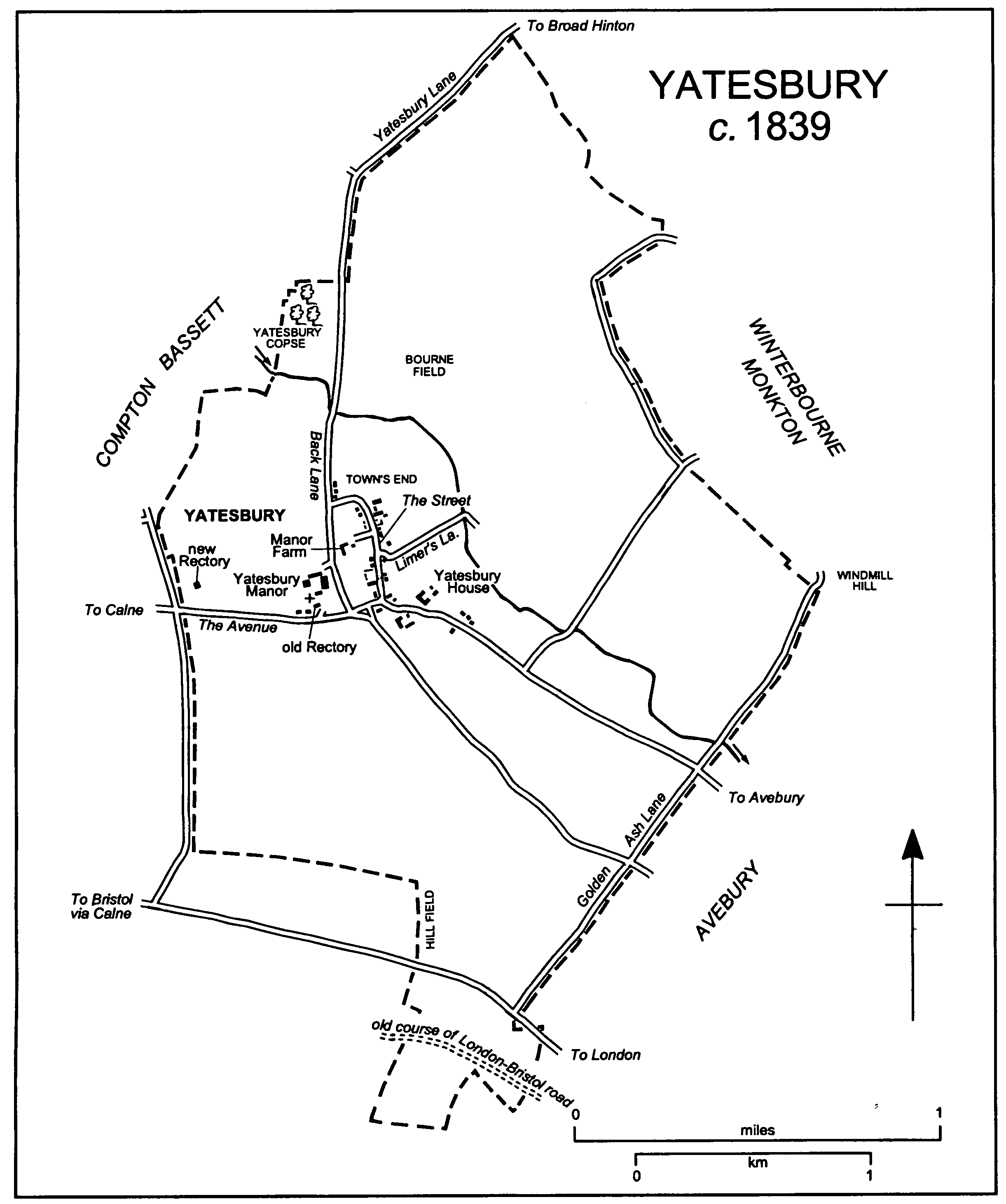
Yatesbury c. 1839
A Bronze-Age earthwork, possibly a cursus, has been identified in the south corner of the parish. There are also two barrows in that corner and others in, south-east of, and west of Yatesbury village. (fn. 17)
Settlement on a site in Yatesbury village was evidently continuous from the Romano-British period, and by the 11th century the site had apparently been acquired by Calne church. Two farmsteads of the manor which belonged to that church and later to Salisbury cathedral, the demesne farmstead and that now called Manor Farm, were built a short distance north of the site, and customary tenements of that manor were built along a north–south street a little east of it. (fn. 18) Early inhabitants of the manor are likely to have attended Calne church. (fn. 19) The present Manor Farm is a house built of chalk in the 17th century, encased in brick in the 18th, and enlarged in the 19th. In 1795 there were c. 12 tenements and several cottages in the street, which had a back lane to the west, and several cottages on the waste at the north end of the back lane; (fn. 20) the Street and Back Lane were so called in the 20th century. In 1994 two timberframed houses of 17th-century origin survived on the west side of the Street, and an 18thcentury cottage much extended in the 20th century stood on the east. In 1879 the group of five cottages at the junction of the Street and Back Lane was called Town's End. (fn. 21)
It is probable that in the earlier Middle Ages most of the demesne was separated from Yatesbury manor and became two manors, one east and one west of the village, and that new buildings were erected on each. (fn. 22) The farmsteads on the eastern manor are likely to have been at the south end of the Street on the east side. (fn. 23) Between 1773 and 1828 two new farmsteads were built, one on each side of the Avebury road south-east of its junction with the Street. (fn. 24) At the north-eastern farmstead Yatesbury House, the present farmhouse, is of red brick and mainly of the mid 19th century. The farmhouse of the south-western farmstead was demolished c. 1975, (fn. 25) and most of the buildings of both farmsteads were replaced in the 20th century. Two or more cottages stood south-east of the site of Yatesbury House in 1795, (fn. 26) five stood there c. 1839, (fn. 27) and in 1879 a group of eight there was called Little London. (fn. 28)
The western manor was called Westcourt, (fn. 29) and Yatesbury Manor probably stands on the site of its principal farmstead. A church, which became the parish church, and a rectory house were built nearby. (fn. 30) Yatesbury Manor was built in the late 17th century or the early 18th; it had a main east–west range with a south entrance front, and a short north wing at the range's east end. It was altered, enlarged, and joined to extensive outbuildings in the 19th century. Farm buildings which stood south-east of it c. 1839 were replaced by others east of Back Lane in the later 20th century. (fn. 31) In the 19th century the rectory house was demolished and a school was built near the site. (fn. 32) A few cottages stood beside the Avenue and near the church in 1773; (fn. 33) a group of three on that site in 1879 was called Vulpit. (fn. 34)
In the earlier 19th century a new rectory house was built near the parish boundary west of the church. (fn. 35) In 1879 there were 57 houses in the parish. (fn. 36) As the population fell sharply in the 1880s (fn. 37) some were demolished; in 1885 there were only two cottages at Town's End and two at Little London, in 1922 none at Town's End. (fn. 38) There was little new building in the parish until the 1930s. By 1934 four council houses had been built in the Street and four beside the lane along the western boundary and near Nolands Farm in Compton Bassett; 12 were built in Limer's Lane east of the Street c. 1952 and two pairs of bungalows were built in Limer's Lane c. 1970. (fn. 39) There was some infilling in the village in the later 20th century.
Yatesbury airfield, in use in the First World War and from 1936, lay south-west of Yatesbury village and mainly in Cherhill and Compton Bassett parishes. About 1938 a large hutted camp for R.A.F. Yatesbury was built on the Cherhill-Yatesbury boundary south-east of the airfield, and a signals school was built south-west of Windmill Hill and in Yatesbury parish. The station was closed in 1964, by 1969 the buildings of the camp had been removed, and between 1970 and 1972 Wiltshire county council restored the camp to farmland. (fn. 40)
MANORS AND OTHER ESTATES
The land of Yatesbury was possibly part of the large estate called Calne held by the king from the 9th or 10th century. Agricultural land at Calne held by Calne church in 1086 was almost certainly granted to it by the king, (fn. 41) and in 1086 Nigel, probably Nigel the physician, claimed to hold Yatesbury as part of the church's estate. He was disputing the right of Alfred of Epaignes, who then held Yatesbury, and was supported by the shire which found that Calne church and not Alwi, as was otherwise stated, had held Yatesbury in 1066. (fn. 42) Nigel's claim was at least partially successful: it is probable that the estate was divided and that demesne in the centre of the parish and most of the customary land passed with Calne church to Salisbury cathedral. (fn. 43) By 1210 a prebend in the cathedral, Yatesbury prebend, had been endowed with YATESBURY manor by the dean and chapter, (fn. 44) and the manor, c. 365 a. c. 1839, (fn. 45) belonged to the prebendary until it was vested in the Ecclesiastical Commissioners in 1853. (fn. 46) In 1863 the commissioners sold the land to John Tuckey. Later the estate was divided; part was bought by Lucy Tanner and added to the Yatesbury House estate and the rest was bought by Charles Tanner and added to Yatesbury Manor farm. (fn. 47)
Part of the estate disputed in 1086 was probably the origin of a manor which came to be called YATESBURY HOUSE farm; much of the manor lay in the east part of the parish and probably derived from demesne land of the estate. Matthew FitzHerbert (d. 1231) held the manor c. 1217 and it passed to his son Herbert FitzMatthew. (fn. 48) In 1239 Herbert was granted free warren in his demesne at Yatesbury, (fn. 49) in 1242–3 he held the manor in chief, (fn. 50) and at his death in 1245 he was succeeded by his brother Peter. (fn. 51) By 1250 the king had taken the manor from Peter as the land of a Norman, and in 1252 he granted it to Robert Waleran (fn. 52) (d. 1273). It passed, presumably after the death of Robert's relict Maud who held it as dower, (fn. 53) to his sister-in-law Isabel Waleran (d. 1284). (fn. 54) In 1289 it was held by Queen Eleanor for Isabel's son John Waleran, an idiot. (fn. 55) John died c. 1308, and in 1310 his estate at Yatesbury was divided between his mother's great-grandnephew Ralph Butler and her grandniece Joan, the wife of Alexander de Freville, each of whom received a moiety. (fn. 56)
In 1313 or 1314 Joan Freville conveyed her moiety, thereafter sometimes called Yatesbury manor, to Henry Wilington and his wife Margaret. (fn. 57) Henry forfeited it in 1322; (fn. 58) the king held it in 1326 (fn. 59) and John Wilington held it in 1331. (fn. 60) Baldwin de Freville held the manor at his death in 1343 and was succeeded in turn by his son Sir Baldwin (fn. 61) (d. 1375) and Sir Baldwin's son Sir Baldwin (fn. 62) (d. 1387). In 1377 Sir Baldwin granted the manor for life to Thomas Preston, (fn. 63) later for life to John Preston (d. 1411). (fn. 64) The reversion passed to his son Sir Baldwin Freville (d. 1400), whose heir Baldwin died a minor in 1418. (fn. 65) Baldwin's heirs were his sisters Elizabeth, the wife of Thomas Ferrer, and Margaret, the wife of Hugh Willoughby, and his nephew Robert Aston. (fn. 66) The manor was partitioned: by 1428 Elizabeth's portion had apparently passed to George Westby, (fn. 67) in 1435 the Willoughbys held a third, (fn. 68) in 1448 the Crown held one of those two portions, (fn. 69) and in 1494 Sir John Aston conveyed what had presumably been Robert's portion to Richard Cuffe (fn. 70) (d. 1504). Richard's heir was his daughter Maud, the wife of John True. (fn. 71) Most or all of the land in those three portions was probably the estate held in 1594 by John Drew and called Yatesbury manor. (fn. 72) John's estate was held in 1632 by Robert Drew (fn. 73) (fl. 1640) and it passed in the direct line to Robert (fn. 74) (fl. 1680), William (fn. 75) (fl. 1701), (fn. 76) and Thomas (fl. 1711). (fn. 77) It is likely to have been the estate acquired by Gilbert Serle in 1713. (fn. 78) In 1780 Gilbert's estate was held by his son Peter, who apparently sold it to a Mr. Tanner c. 1789. (fn. 79)
The manor divided in 1310 had probably been reunited by 1743, (fn. 80) and Tanner held the whole of it in 1795. (fn. 81) From 1810 or earlier the manor was held by William Tanner (d. 1826), and it descended in turn to his son John (d. 1859) and John's son John (d. 1864). (fn. 82) About 1839, as Yatesbury House farm, it measured 751 a. (fn. 83) In 1894, then 910 a. including land which formerly belonged to the Ecclesiastical Commissioners, the farm was sold by the younger John's relict Lucy Tanner, his son J. A. C. Tanner, and other members of his family to trustees of Charles Harris (d. 1871) of Calne. (fn. 84) About 1930 it passed, presumably by purchase from the trustees, to F. C. Carr; (fn. 85) in the late 1930s some of the land was sold for the wireless school and camp of R.A.F. Yatesbury, (fn. 86) and in 1939 the rest of the farm belonged to L. E. Turner. (fn. 87) In 1995 Yatesbury House farm, c. 700 a., belonged to Mr. and Mrs. G. R. Gantlett. (fn. 88)
The moiety of John Waleran's estate assigned in 1310 to Ralph Butler (d. 1343) (fn. 89) was held as dower by his relict Hawise (d. 1360) and passed to his grandson Sir Edward Butler, (fn. 90) who apparently sold it to John Davy in or before 1365. In 1395 Davy's daughter Alice held the estate with her husband John Poyntell, (fn. 91) and in 1396 the Poyntells conveyed it to John Hartham. (fn. 92) By will proved 1402 (fn. 93) Hartham devised it to his daughter Joan, but it was claimed by his relict Margery, the wife of William Botreaux. By 1428 Botreaux had acquired the estate, probably by a grant from Joan, (fn. 94) and he held it in 1432. (fn. 95) The estate was apparently that conveyed in 1467 among trustees and in 1510 by Edward More to Richard Fynemore (fn. 96) (d. 1522). Fynemore's estate at Yatesbury descended with Whetham manor in Calne parish to Walter Fynemore (d. 1557), Roger Fynemore (d. 1574 or 1575), and Mary Fynemore (d. by 1587), the wife of Michael Ernle (d. 1594), the owner of Westcourt manor. Mary's estate was evidently sold either by her son and heir Sir John Ernle (d. 1648) or by Sir John's son John. (fn. 97) In 1670 the estate, 255 a. and pasture rights, was settled on Nathaniel and Cecilia Trotman. (fn. 98) Its descent from 1670 is obscure; probably by 1743 and certainly by 1795 it had been reunited with the part of the manor separated from it in 1310. (fn. 99)
The manor of WESTCOURT consisted mainly of demesne in the west part of the parish, (fn. 100) and was probably the third part of the Yatesbury estate disputed in 1086. From the 13th century to the 15th the overlordship of it was sometimes said to be part of the earldom of Salisbury, (fn. 101) and sometimes of the duchy of Lancaster. (fn. 102)
What was probably the manor was held in 1199 by Reynold of Calne; (fn. 103) in 1242–3 he or a namesake held 2 knight's fees at Yatesbury, including 1 of a mesne lord, Walter son of Bernard. (fn. 104) By 1249 the manor had passed to Walter, the son of Reynold (fl. 1242); (fn. 105) it was presumably the estate held by William of Calne in 1272 or later, (fn. 106) and was that of 2 carucates held by Nicholas Burden (d. by 1301). (fn. 107) Nicholas's relict Agnes held it as dower (fn. 108) and later married Henry de Freynes (fn. 109) and afterwards Sir Peter Doygnel. On her death in 1349 Westcourt manor passed to Nicholas's son Nicholas Burden (fn. 110) (fl. 1351), (fn. 111) and it descended to that Nicholas's son Edmund (d. 1361), who left a wife Agnes and a son John, a minor. (fn. 112) In 1381 John (d. 1395) settled the manor on Agnes and on John Russell apparently for life. (fn. 113) John Burden's heir was his daughter Cecily, whose husband Henry Thorp (d. 1416) held the manor from 1402. (fn. 114) On Cecily's death in 1422 it passed to her son Ralph Thorp, (fn. 115) who settled it in 1423 on Thomas Worston and his wife Cecily in tail with remainder to John Ernle. (fn. 116) John probably held the manor in 1432 and 1436; the John Ernle who probably held it in 1505 (fn. 117) was presumably the John Ernle who died in 1519. The manor apparently descended in the direct line to John (d. 1555), John (d. 1572), and Michael Ernle, who held it at his death in 1594 and in his wife's right also held part of the manor which came to be called Yatesbury House farm. Westcourt manor passed to Michael's son Sir John, (fn. 118) who apparently conveyed it after 1617 to Thomas Smith (d. 1637). Thomas settled it on his daughter Mary (d. by 1654) on her marriage to Charles Seymour (from 1664 Lord Seymour, d. 1665), and it descended to Mary's daughter Frances Seymour (fn. 119) (d. 1715), the wife of Sir George Hungerford (d. 1712), the lord of Studley manor in Calne. Frances's heir was her son Walter Hungerford (d. 1754), and Westcourt manor descended with Studley manor to Walter's nephew George Hungerford (d. s.p. 1764), (fn. 120) who devised it to his wife Elizabeth (fn. 121) (d. 1816). Elizabeth's heir was her nephew Richard Pollen (d. 1838), whose son Richard (fn. 122) sold the manor, 429 a. c. 1839, (fn. 123) to John Tanner (d. 1859) c. 1848. (fn. 124) The land passed to John's son Charles (fn. 125) and to Charles's mortgagees Sir William Fairfax, Bt., and W. J. Pawson (d. 1890). Pawson's interest passed to W. H. Pawson, who in 1900 owned the land as Yatesbury Manor farm and in 1907 sold it to George Cowing. In 1910 Cowing (d. 1913) owned Yatesbury Manor and 696 a. (fn. 126) In 1939 his trustees sold 169 a. to the Secretary of State for Air for R.A.F. Yatesbury, and in 1972 sold the rest to W. Cumber & Son (Theale) Ltd. The 169 a. was sold by the Ministry of Defence to Wiltshire county council in 1970, by the council to Cowing's trustees in 1972, and by the trustees to W. Cumber & Son in 1973. (fn. 127) The company remained the owner of the whole farm until 2000, when it sold it in portions and 270 a. south of the Avenue was bought by members of the Pickford family and added to Upper farm, Cherhill. (fn. 128)
In 1242–3 Henry of Hartham held 1/10 knight's fee in Yatesbury, Roger of Somerford ¼ knight's fee, William of Hampton 1/6 knight's fee, and Roger of Alrinton 1/5 knight's fee, all of Herbert FitzMatthew. (fn. 129) Only Henry's estate can be traced later. It apparently passed to Martin of Hartham, who settled it on himself and his wife Parnel in 1258. (fn. 130) In 1391 John and Alice Poyntell conveyed what was evidently the same estate to John Hartham; (fn. 131) that estate was presumably merged with Hartham's other estate in Yatesbury. (fn. 132)
An estate in Yatesbury was held from 1412 by St. Mary's priory near Marlborough. In 1539 it passed to the Crown when the priory was dissolved, and in 1553 was granted to William Herbert, earl of Pembroke (d. 1570). (fn. 133) In 1567 the estate consisted of 175 a. with pasture rights. (fn. 134) All or part of the estate passed with the earldom to Philip, earl of Pembroke and of Montgomery (d. 1683), who held part of it in the year of his death. (fn. 135) Before 1682, however, what may have been a large part was apparently acquired by Robert Drew, (fn. 136) and by 1795 the whole estate had been merged with what had been Drew's. (fn. 137)
ECONOMIC HISTORY
In 1086 Yatesbury had land for 4 ploughteams. The demesne was assessed at 3½ hides and there were 2 teams and 2 servi on it; 7 bordars and 1 knight had 1 team; and there was 20 a. of pasture. (fn. 138) Afterwards that estate was probably divided into three manors, (fn. 139) and each of two of the manors in the parish had its own set of open fields and the third probably had. (fn. 140)
The arable of Yatesbury manor remained in open fields until the mid 19th century. (fn. 141) In 1795 Bourne field, c. 150 a., lay north of the village, and Hill field, c. 175 a., was a long and narrow field extending into the parish's south corner. (fn. 142) There was evidently common pasture for sheep in the north and south corners of the parish. In 1309 the men of Yatesbury manor shared with the men of the manor which came to be called Yatesbury House farm a sheep pasture called North leaze, apparently in the north corner; a common flock was overseen by a shepherd acting for both manors. (fn. 143) Probably in the early 17th century and certainly before 1648 some common pastures and meadows were inclosed. (fn. 144) North leaze had been inclosed by the 18th century, when closes totalling c. 50 a. in the north corner were in holdings of Yatesbury manor. In the south corner the downland, c. 70 a., which was apparently separated from Hill field by the new course of the London–Bristol road, was probably sheep pasture shared by the men of Yatesbury manor with the men of the other two manors. It had been inclosed by 1795 and c. 20 a. allotted for Yatesbury manor. (fn. 145) In 1086 Yatesbury's land was 70 per cent demesne, (fn. 146) and those parts of the demesne east and west of the village were probably the origins of Yatesbury House farm and Westcourt manor. (fn. 147) The demesne of Yatesbury manor included only 60 a. of arable in 1405, when eight customary tenants held 120 a. of arable. (fn. 148) In the mid 18th century the demesne, of 3 yardlands, included 6 a. of meadow, 6 a. of pasture, a nominal 79 a. of arable, and feeding for 120 sheep. There were 4 copyholds each of 1 yardland, 5 of ½ yardland, and 5 of ¼ yardland, and all had buildings in the Street. The copyholds included 37 a. of meadow, 43 a. of pasture, a nominal 166 a. of arable, and feeding for 300 sheep. (fn. 149) Other land of the manor was held freely. Much of the demesne arable lay in large parcels. (fn. 150) By 1818 most of the copyhold land had been added to the demesne farm. (fn. 151) The farm was called Manor farm c. 1839, when it measured 327 a.; there was then a freehold of 44 a., and none of the copyholds exceeded 20 a. (fn. 152) Common husbandry was presumably eliminated as copyholds fell in hand in the mid 19th century.
On the manor which came to be called Yatesbury House farm there were two open fields in 1205, (fn. 153) presumably the East field and South field mentioned in 1309. A pasture called North field was in 1309 shared between the lord and tenants of the manor as feeding for beasts in summer and was grazed by the tenants' sheep in winter; the men of the manor also had a share in the feeding for sheep in North leaze (fn. 154) and probably in the parish's south corner. North and South were open fields in 1567, (fn. 155) and in the 17th century there were three open fields, East, which adjoined the eastern parish boundary, South, which lay south-east of the village, and North, which presumably lay north-east of the village, a total of c. 400 a. (fn. 156) After inclosure c. 60 a. of North leaze and 36 a. of the southern downland were part of the manor. (fn. 157) The manor probably originated in land which was demesne in 1086, (fn. 158) and it included much more demesne than customary land. In 1250 the demesne comprised 227 a. of arable and 8 a. of meadow. (fn. 159) In 1309 there were 217 a. of demesne arable and a several demesne pasture worth 12d., and eight customary tenants held 35 a. of arable between them. The largest customary holding was of only 21 a., and the tenants owed onerous labour services, including mowing, carrying, and stacking hay, carrying hurdles and other goods, and weeding. (fn. 160) When the manor was divided in 1310 about half the demesne and half the customary land were included in each purparty. (fn. 161) In the 16th century holdings with lands in the fields of the manor included one of 80 a., one of 138 a., and one of 38 a. (fn. 162) In 1670 one was said to be of 255 a. (fn. 163) and there may have been another of roughly equal size. The holdings were all in single ownership in the 18th century, (fn. 164) and common husbandry was eliminated between 1711 and 1795. (fn. 165) Two new farmsteads were built, one each side of the northern road to Avebury, (fn. 166) and that road may perhaps have divided two large farms held in severalty. About 1839, however, all the land and both farmsteads were in Yatesbury House farm, 751 a. (fn. 167)
In the west part of the parish there probably lay a third set of open fields. Westcourt manor, bounded to the east by Yatesbury Lane, Back Lane, the north-west part of Barrow Lane, and Hill field, apparently included open-field arable in 1301, (fn. 168) and 1 a. of glebe in an otherwise several field remained as a probable vestige of it c. 1839. (fn. 169) Westcourt manor, like the manor which became Yatesbury House farm, probably originated in land which was demesne in 1086, (fn. 170) and in 1310, when the only customary tenants were 1 yardlander and 5 cottagers, the demesne comprised 200 a. of arable, 3 a. of meadow, and several pasture valued at 19s. 4d. (fn. 171) The demesne and the customary yardland presumably included common pasture rights and, after it was inclosed, 15 a. of the downland in the parish's south corner was part of the manor. (fn. 172) All the land of the manor seems to have been in a single farm in 1671 and 1795; (fn. 173) c. 1839 it was a farm of 429 a., (fn. 174) later called Yatesbury Manor farm.
About 1839 the parish was two thirds arable and a third grassland; of the grassland only 51 a. was downland. (fn. 175) The proportions may have changed little by c. 1879, when there were said to be large flocks of sheep in the parish. (fn. 176) By 1885 some arable had been laid to grass and part of Manor farm added to Yatesbury House farm, which then included 631 a. of arable and, including the 51 a. of downland pasture in the south corner of the parish, 259 a. of meadows and pasture. (fn. 177) In 1910 Yatesbury House farm measured 899 a., Yatesbury Manor farm 696 a. (fn. 178) In the period 1903–7 racehorses were trained on Yatesbury Manor farm, (fn. 179) in 1914 the farm was mainly pasture and supported mixed stock, in the 1920s and 1930s it was a stud farm for shire horses with at most 100 stallions, and in the 1940s and 1950s it was used to rear cattle for beef. (fn. 180) Both Yatesbury House farm and Yatesbury Manor farm were made smaller in the 1930s, when land was taken for R.A.F. Yatesbury, (fn. 181) but enlarged again later. From 1966 Yatesbury Manor farm was principally arable; in 1995 cereals were grown on c. 500 a., beans were grown on 100 a., c. 60 a. was pasture, and c. 120 a. was set aside. (fn. 182) In 1968 Yatesbury House farm had 418 a. and was principally arable; (fn. 183) in 1995 it was an arable and stock farm of c. 700 a. (fn. 184)
In 1773 and c. 1839 Yatesbury copse, 5 a. north of the village, was the only woodland. North-east of that, 8 a. was planted in the mid 19th century. (fn. 185) All 13 a. was standing in 1995.
In 1309–10 a windmill stood on the manor which became Yatesbury House farm, (fn. 186) perhaps on Windmill Hill. Iron working south-east of Manor Farm in the later Middle Ages may have served the needs of no more than the parish. (fn. 187) A clothworker lived at Yatesbury in 1683. (fn. 188) Trades followed in the earlier 19th century included plaiting straw and knitting woollen stockings; (fn. 189) later in the century the only trades were those usual in a small rural parish. (fn. 190)
LOCAL GOVERNMENT
A court was held for Yatesbury manor. In 1716–17 and 1719, as presumably earlier, the spring meeting was held with a view of frankpledge. The combined court proceeded on the presentments of a joint homage and jury; a tithingman, a constable, and a hayward were appointed, matters presented included breaches of custom in the use of common pastures, encroachment on the highway, and vacant holdings, and tenurial business was transacted. (fn. 191) The court continued to be held until the mid 19th century, (fn. 192) sometimes nominally with a court leet, but after c. 1720 there were few presentments under leet jurisdiction. (fn. 193)
In 1775–6 £41 was spent on poor relief, in the three years to Easter 1785 c. £37 a year. Expenditure had risen to £163 by 1802–3, when 50 adults and 34 children received permanent relief and 10 people occasional relief. (fn. 194) In 1812–13 £381 was spent, in 1814–15 £234. Noone is said to have received permanent relief, and figures given for the numbers receiving occasional relief in those years, 439 and 342 respectively, may refer to the number of doles distributed. (fn. 195) Between 1817 and 1819 c. £340 was spent yearly, in the 1820s usually less than £250, (fn. 196) and between 1831 and 1834 an average of £318. Yatesbury joined Calne poor-law union in 1835 (fn. 197) and became part of North Wiltshire district in 1974. (fn. 198)
CHURCH
Yatesbury church was standing in the 13th century and perhaps in the 12th. (fn. 199) It was served by a rector in the 13th century, (fn. 200) and the living remained a rectory until 1973, when it was united to other benefices to form Oldbury benefice. (fn. 201) In the 14th century the church was also served by a vicar. In 1305 the bishop of Salisbury collated one by lapse; (fn. 202) later others were presented by the rector. (fn. 203) The vicarage was not endowed, (fn. 204) and no reference to a vicar later than 1362 has been found. (fn. 205)
The church was apparently built on Westcourt manor, (fn. 206) and the advowson of the rectory passed with the manor from Nicholas Burden (d. by 1301) (fn. 207) to Sir John Ernle (d. 1648). (fn. 208) A grant of it by the Crown to William, earl of Pembroke, in 1553 (fn. 209) was void. From Sir John Ernle the advowson descended with Whetham manor in Calne in the Ernle, Money, and Money-Kyrle families until 1853, when William Money-Kyrle sold it to A. C. Smith, whom he had presented as rector in 1852. (fn. 210) In 1680 John Ernle's right to it was unsuccessfully challenged by Sir George Hungerford, who then held Westcourt manor in his wife's right. (fn. 211) Smith sold the advowson c. 1882, (fn. 212) probably to the Revd. H. L. Guillebaud (d. 1900), who presented his son E. D. Guillebaud (d. 1907) in 1889. The advowson passed to the younger Guillebaud, to his relict Mary for life, and to his son H. E. Guillebaud, (fn. 213) who in 1928 transferred it to the Church Pastoral Aid Society. (fn. 214) In 1994 the society was a member of the patronage board for Oldbury benefice. (fn. 215) On 10 or more occasions the rector was not presented by the owner of the advowson. The king presented twice in 1304, when he had the keeping of the lands of Nicholas Burden (d. by 1301). (fn. 216) A presentation made in 1361 by Agnes, the relict of Edmund Burden (d. 1361), was disputed by the king as keeper of the inheritance of John Burden, a minor, and in 1365 the king successfully presented a new rector. (fn. 217) Presentations by grant of a turn were made by Roger Chivers in 1598 and Thomasine Chivers in 1602, and presentations presumably by such a grant were made by Thomas Worston in 1383, John Lunford twice in 1471, Sir Edward Baynton in 1637, and Thomas Fettiplace in 1708. (fn. 218)
The rectory was worth £10 in 1291, (fn. 219) £17 in 1535, (fn. 220) and £455 c. 1830, (fn. 221) in each case a value above the average for a living in Avebury deanery. In 1428 the rector was paying 6s. 8d. a year to Kington St. Michael priory from the rectory; (fn. 222) no other reference to the pension has been found. The rector was entitled to all tithes from the whole parish; in 1839 they were valued at £510 and commuted. (fn. 223) The glebe was assessed at 1 yardland in 1341 (fn. 224) and was accounted c. 32 a. in 1613 (fn. 225) and 27 a. in 1839; (fn. 226) 13 a. was sold in 1919. (fn. 227) There was a house on the glebe in 1613, (fn. 228) perhaps the rectory house which stood south-east of the church in the early 19th century. (fn. 229) Although the house was said to be fit for residence c. 1830, (fn. 230) work on a large new stone house 500 m. west of the church began in 1832. (fn. 231) The old house was demolished. (fn. 232) The new house, completed in 1843, (fn. 233) was sold in 1951. (fn. 234)
William de Wheatley, author of a commentary on Boethius, was rector for a short time in 1317. (fn. 235) In 1553 no quarterly sermon was preached and there was no cover for the holy table. (fn. 236) Nathaniel Webb, rector from 1656, was ejected as a nonconformist in 1662, (fn. 237) when the church lacked the Book of Homilies, Jewell's Apology, a chest for alms, and a chest for books and ornaments. (fn. 238) The rector 1708–35 and the rector 1735–93 were pluralists and probably non-resident. In 1783 the church was served by a curate who also served Compton Bassett and lived at Calne. At Yatesbury a service was held each Sunday afternoon; the only additional service was on Good Friday. Communion was celebrated at Christmas, Easter, and Whitsun, and received by c. 15 parishioners. (fn. 239) On Census Sunday in 1851 morning service was attended by 49 adults and afternoon service by 80 adults. (fn. 240) In 1864 Sunday services were still held morning and afternoon, each with a sermon; there were additional services on holy days and in Lent, and communion was celebrated four times. (fn. 241) Yatesbury was served in plurality with Cherhill 1951–72, and as part of Oldbury benefice was served by a team ministry 1973–7 and a group ministry from 1978. (fn. 242)
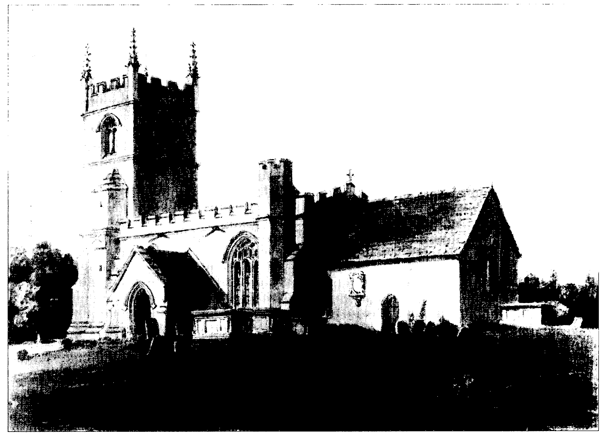
All Saints' church from the south-east in 1806
One acre, from which 12s. was received in 1796, and another small piece of land were held for the church. Those lands were exchanged in 1848 for 1 a., then let at £5 a year. The income was £2 1s. 8d. in 1905, over £3 in 1931. The land was later sold, and in 1994 income from the invested proceeds was used for church expenses. (fn. 243)
ALL SAINTS' church, so called in 1763, (fn. 244) is built of chalk blocks and freestone and has a chancel with north vestry, a nave with north aisle and south porch, and a west tower. The animal-head label stops of a reset doorway are 12th-century and the oldest masonry in the church. The present nave was built in the 13th century with north and south aisles, each with a three-bayed arcade, the north aisle being narrow. The chancel was probably rebuilt or lengthened in the 14th century. In the 15th century the south aisle and all but the central bay of its arcade were demolished, the doorway bearing the 12th-century stops was set in the surviving bay, and the porch was built; the whole doorway is in 12th-century style but apart from the stops is 19th-century. Also in the 15th century the tower was built, new windows were inserted in the chancel and the north aisle, and the nave roof was renewed and given a celure above a rood loft which was approached by a stair turret in the new south wall. (fn. 245) In 1854 the church was restored under the direction of C. H. Gabriel. The chancel, which by then had been ceiled, was rebuilt with the vestry and in a 14th-century style, the chancel arch was enlarged, a west gallery was removed, and the whole church was repaired and refitted. (fn. 246)
In 1553 plate weighing 3 oz. was confiscated and a chalice weighing 8 oz. was left in the church. In 1854 a chalice, a paten, a flagon, and an almsdish, all of pewter, were recast as a ewer for baptism. A chalice, two patens, and a flagon, all apparently of silver, were held by the church in 1995 and were probably given in 1854. (fn. 247)
Three bells hung in the church in 1553. The treble and the tenor were replaced by bells cast in 1636, and the middle bell was replaced by one cast by a member of the Cor family in the late 17th century or earlier 18th. In 1773 a fourth bell was replaced by one cast by Robert Wells, and a fifth, by John Taylor & Co. of Loughborough (Leics), was added in 1931. (fn. 248) All five bells hung in the church in 1995. (fn. 249)
Registers of baptisms, marriages, and burials survive from 1706 and are apparently complete. (fn. 250)
NONCONFORMITY
A mass centre either in Yatesbury or Cherhill parish was opened at R.A.F. Yatesbury in 1940. (fn. 251)
In 1662 Nathaniel Webb, rector of Yatesbury, was a nonconformist, (fn. 252) and in 1676 there were six Protestant dissenters in the parish. (fn. 253) Although in 1783 there was said to be no nonconformist in Yatesbury, (fn. 254) in 1787 a house was licensed for Independent meetings. In 1822 a house was licensed for Baptist meetings, (fn. 255) and a small Wesleyan chapel, built in 1839, (fn. 256) was open in 1855. (fn. 257) From 1874 Baptists, who until then worshipped in a cottage, used the chapel as a mission room of the chapel in Castle Street, Calne. (fn. 258) The congregation at Yatesbury in 1909 numbered c. 20. (fn. 259) The room was open in 1939, (fn. 260) but not in 1994.
EDUCATION
The first school in Yatesbury was opened in 1832 and had 10 pupils in 1833. (fn. 261) A school and a teacher's house were built near the site of the old rectory house in 1856. (fn. 262) The school had 25–30 pupils in 1859, (fn. 263) 25 in 1871. (fn. 264) Average attendance was 14 in 1907, 21 in 1913, 34 in 1919, and 22 in 1936. (fn. 265) The school was closed in 1963. (fn. 266)
CHARITY FOR THE POOR
None known.