A History of the County of Shropshire: Volume 11, Telford. Originally published by Victoria County History, London, 1985.
This free content was digitised by double rekeying. All rights reserved.
'Wrockwardine', in A History of the County of Shropshire: Volume 11, Telford, (London, 1985) pp. 306-310. British History Online https://www.british-history.ac.uk/vch/salop/vol11/pp306-310 [accessed 25 April 2024]
WROCKWARDINE
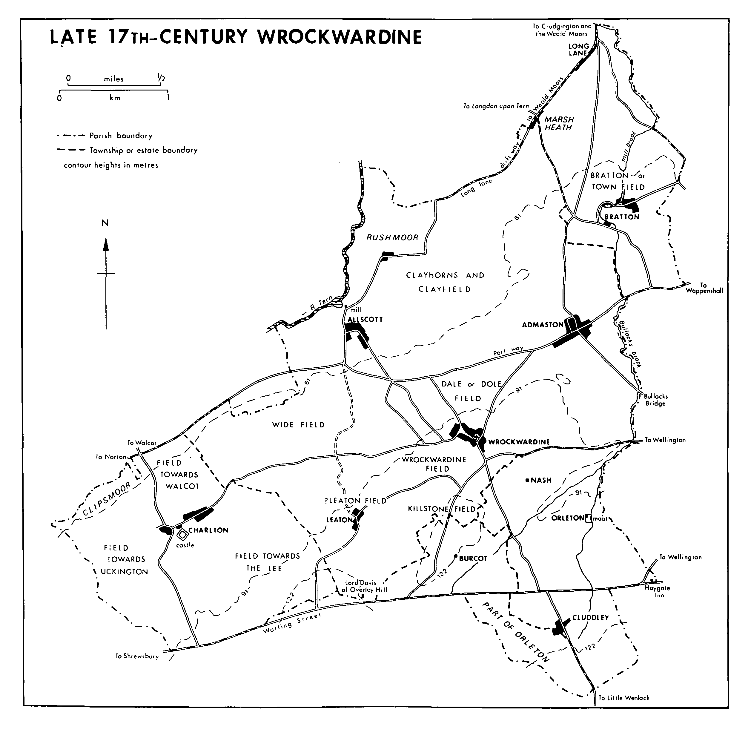
Wrockwardine, a mainly rural parish, lies south and east of the river Tern and north of Watling Street; the western boundary is mostly with Wroxeter parish and to the east lies the northern part of Telford new town. The main part of the ancient parish, dealt with here, included the townships of Wrockwardine, Admaston, Allscott, Bratton, Charlton, Cluddley, Leaton, and Long Lane, the capital messuages of Burcot and Orleton, and the deserted settlement and former township of Nash. (fn. 1) A detached township of the ancient parish, Wrockwardine Wood, lay 7 km. to the east; its history is treated separately below. (fn. 2)
To the north the parish is bounded partly by Long Lane, the river Tern, and the road from Allscott to Watling Street at Norton. The western boundary of the parish and of Charlton township partly follows a stream. To the south the parish boundary largely follows the original line of Watling Street: the boundary - the 'king's boundary' - diverged northwards from the road at Overley Hill by 975, and southwards around Cluddley, probably by the Saxon period. (fn. 3) Bullocks brook, so called by 1580, (fn. 4) largely forms the eastern parish boundary, though Bratton and Orleton townships both extend east of it. (fn. 5)
In 1882 Wrockwardine civil parish contained 4,762 a. (1,927 ha.), including 515 a. in Wrockwardine Wood and 92 a. of detached moorland north of Eyton upon the Weald Moors. (fn. 6) In 1884 Wrockwardine Wood became a separate civil parish and the moorland was transferred to Eyton C.P. At the same time the transfer of Walcot township (414 a.) from Wellington C.P. with 13 a. from Rodington C.P. increased the length of the parish boundary formed by the river Tern. (fn. 7) In 1903 and 1934 3 a. and 165 a. respectively of land east and south of Cluddley and Orleton were transferred to Wellington Urban C.P. (fn. 8) The eastern part of the parish, including Admaston and Bratton villages, was included within the designated area of Telford new town in 1968. (fn. 9)
Crossing the parish from south-west to northeast are the Brockton and Burcot faults, c. 1 km. apart. Between them outcrop Uriconian Rhyolite, particularly between Overley Hill and Leaton and west of Wrockwardine, and tuff, on which Wrockwardine village lies. (fn. 10) From those high outcrops the ground falls away northwards to the Tern and the Weald Moors and southwards to low ground at the foot of the Wrekin. Cluddley extends southwards to the base of the Wrekin. It was presumably the commanding views obtained from Wrockwardine church tower that led to its seizure by Parliamentarian troops in 1645-6. (fn. 11) Most of the rest of the parish lies on boulder clay or sand and gravel, while some terrace gravel is associated with the river Tern and Rushmoor lies on lake clay. (fn. 12)
Late 17th- Century Wrockwardine
Domesday Book recorded 32 inhabitants in Wrockwardine and Bratton, (fn. 13) and 25 parishioners paid to the 1327 subsidy, but there is no indication that Charlton and Orleton were included in the latter total. (fn. 14) In 1349 manorial income had fallen 'because the tenants there are dead', but by 1367 it was back at the levels obtaining before the Black Death, a fact perhaps suggesting a population recovery. (fn. 15) In 1672 hearth tax was paid by 77 people: 12 in Wrockwardine, 16 in Charlton, 12 in Admaston, 10 in Allscott, 9 in Bratton, 9 in Leaton, Burcot, and Cluddley, 6 in Long Lane, and 3 at Orleton and Nash; (fn. 16) the proportions accord with those of the 1539 muster. (fn. 17) The population was 1,033 in 1841, 1,380 in 1961, and 2,105 in 1981, (fn. 18) Admaston's growth largely accounting for an increase in the 1960s.
South of Bratton is a multi-period prehistoric site with Bronze Age ring ditches and Iron Age or Romano-British ditches and enclosures. (fn. 19) Another possible prehistoric enclosure lies east of Charlton castle, (fn. 20) while other possible sites and scattered finds across the parish all attest to activity in the area before Watling Street was made in the initial phase of the Roman conquest. (fn. 21)
It has been suggested that Wrockwardine village was the site of Pengwern, the legendary sub-Roman centre of Powys, destroyed by the Mercians c. 660. (fn. 22) In 1066 it was the centre of a royal multiple estate, probably containing the 7½ berewicks mentioned in 1086. It was a five-hide unit and a hundred meeting place. (fn. 23) Place-name evidence, reinforcing that of Domesday, suggests that Wrockwardine, 'the enclosure (worthign) by the Wrekin', (fn. 24) was an ancient centre around which subsidiary settlements were established. In the parish, lying 1-3 km. from the village, are five places with the element tun in their names, which may be English renamings of older settlements. There are also two with the element cot and three with leah, which may be settlements newly established in the 8th or 9th century in a period of expansion. (fn. 25)
Wrockwardine village is a loose agglomeration of 17th-century and later timber-framed and brick farmhouses and cottages grouped around the church and small green. After c. 1920 the village extended south and roughly doubled in size.
Admaston, 'Eadmund's tun', (fn. 26) grew in the mid 18th century from a rural village into a small spa. (fn. 27) Similar geological formations to those at Kingley Wych saltworks (fn. 28) produced a high saline content in the water. By 1750 Admaston Spa, sometimes known as Wellington Spa, had opened and in 1805 there was a hotel there, which was rebuilt in brick in the early 1840s. It had, roughly, a courtyard plan, with a colonnaded entrance and clock tower; the facilities included a bath house. The spa's profitability declined from the 1860s and it became a private residence in 1890. It was a hotel from c. 1928 to c. 1933 but later a chicken farm, then a lodging house. Telford development corporation bought it in 1975 and renovated it 1978-80, converting it to three substantial houses. (fn. 29) The presence of the spa and (by 1856) a railway halt led to the emergence of Admaston as a small, locally fashionable centre, and several large houses of the 18th and 19th century, such as Admaston Hall, Oaklands, and Donnerville, bear witness to that phase of prosperity. Speculative housing development began south-west of the village in the 1960s and continued after Admaston's inclusion in Telford new town in 1968. (fn. 30)
Bratton, the 'newly cultivated tun', was a small hamlet centred on Bratton Farm in 1839. (fn. 31) Houses were built on the west side of Bratton Road, half way from Bratton Farm to Admaston, before 1930 and on the east side of the road between 1947 and 1953. (fn. 32)
Charlton, 'the tun of the ceorls', (fn. 33) Leaton, 'the tun in the wood or clearing', (fn. 34) Allscott, Ælfwulf's (fn. 35) cot', and Cluddley, 'the leah where burdock grew', (fn. 36) remained in 1982, as they had been in 1839, (fn. 37) hamlets grouped around farmhouses. Leaton Grange incorporates a late medieval hall with crown-post roof.
Any hamlets that may have existed at Orleton, 'the tun of the earls', Burcot, 'the cot belonging to the burg' or 'the dwelling place or cottage', (fn. 38) and Nash, 'at the ash tree', (fn. 39) had disappeared before the early 18th century when only single messuages remained. (fn. 40) Orleton Hall and Burcot Farm remained in 1982 but Nash, a medieval township (fn. 41) where there had been a farm in the later 17th century and a single barn in 1839, (fn. 42) was completely deserted.
By 1650 squatters' cottages had been built along Long Lane, the drift way to the Weald Moors, and probably at Rushmoor. (fn. 43) In 1851 Long Lane was a straggling township of cottages 3 km. long but by 1982 few houses remained outside the hamlets of Long Lane and Rushmoor. (fn. 44) There was already a hamlet called Lea at Overley Hill in 1817. (fn. 45) Overley Hall, a 14-bedroomed red-brick house with 'Tudor' features and a gothic tower, set in 48 a. of grounds, was built in 1882 for Joseph Beattie, a Birmingham banker. (fn. 46) H. H. France-Hayhurst bought it in 1890 (fn. 47) and lived there till 1907. (fn. 48)
Watling Street crosses the parish from east to west. Mentioned in 975, (fn. 49) it remained a major thoroughfare throughout the Middle Ages. The way to the Wrekin, probably the road running south from Wrockwardine village through Cluddley, was mentioned in 1411-12. (fn. 50) Some other roads, though not recorded before the 16th century, are likely to have been medieval; several apparently divided open fields. The drift way to the Weald Moors from Allscott via Long Lane was mapped c. 1580, as were the roads from Longdon upon Tern to Bratton and Wellington and from Wrockwardine to Wappenshall, and probably that leading due east from Wrockwardine. (fn. 51) The Admaston-Wellington road crossed Bullocks brook in 1626 at Bullocks bridge. (fn. 52) Noted in 1674 were the way from Wrockwardine to Burcot, the port or common highway from Admaston to Shrewsbury, the AllscottLeaton bridleway, the Leaton-Wellington market way (perhaps one of the footpaths of 1839 leading east from Leaton), (fn. 53) the Allscott-Charlton and Wrockwardine-Charlton roads with Breadon bridge on the latter, and a footpath from Wrockwardine to 'Winshall' (probably Wappenshall). (fn. 54) A road running north to the Weald Moors from Bratton c. 1580 was disused by 1752. (fn. 55)
Watling Street was turnpiked in 1726. There was a tollgate south of Burcot in 1815. (fn. 56) In 1835-6 one of Thomas Telford's improvements to Watling Street was completed, a 3-km. diversion north to avoid Overley Hill. A new tollhouse was also built at Burcotgate. (fn. 57) The roads to Wellington (via Shawbirch) from Longdon upon Tern and Sleapford (fn. 58) were turnpiked with Watling Street; (fn. 59) both passed through the north-east of the parish, the former having a tollhouse at Bratton. (fn. 60)
In 1975 the interchange between Watling Street and the M 54 motorway was opened north of Cluddley. (fn. 61)
The Shrewsbury Canal passed through Long Lane; it was complete from Trench Pool to there by 1794 and the adjoining length to Shrewsbury opened in 1797. A wharf at Long Lane originally supplied coal and lime to the Shawbury area; in 1898 the Lilleshall Co. used it as a coal wharf and brick yard. (fn. 62) Traffic ceased on the canal in the 1920s. (fn. 63)
Two railway lines crossed the parish, converging on Wellington. That from Shrewsbury to Wellington opened in 1849. (fn. 64) Walcot station and Admaston halt were open by 1851 (fn. 65) and closed in 1964. (fn. 66) The line from Wellington to Market Drayton opened in 1867. It closed to passengers in 1963 and to goods in 1967. (fn. 67) There was a halt north of Bratton. (fn. 68)
Most of the first recorded inns or public houses in the parish lay along Watling Street. The Haygate inn opened between 1625 and 1693. It became known as the Falcon inn c. 1829 and was also known as the Royal Oak. A leading coaching inn from the late 18th century or earlier, it closed c. 1856 after the railway reached Wellington. It then became a farmhouse but reopened as the Falcon hotel in 1971. (fn. 69) The Plume of Feathers, on Watling Street at Overley Hill, opened between c. 1690 and 1721 in, or on the site of, a house known between 1670 and c. 1690 as Lord Davis's. (fn. 70) Also on Watling Street, south of Charlton, was the Blue Bell in 1707; bannering took place there in 1721. (fn. 71) Both probably closed when the road was moved north in 1835; the Blue Bell was apparently out of business by 1838, the Plume of Feathers by 1851. (fn. 72) There was an alehouse at Charlton in 1613. (fn. 73) Most of the public houses open in 1982 dated from the earlier 19th century or before: the Buck's Head, Long Lane, existed by 1810; the Gate inn, Bratton, by 1820, possibly by 1779; (fn. 74) the Fox and Duck near Walcot by 1817 (fn. 75) and the Pheasant, Admaston, by 1846. (fn. 76)
Periodically in the 18th and 19th centuries Admaston Spa was a centre for local genteel society, and in 1851 the locality was known for its steeplechase meetings and field sports. The spa was the meeting place of a masonic lodge between 1852 and 1857. (fn. 77) Several friendly societies existed in the later 18th and 19th century. The Wrockwardine Friendly Society met in the Wheatsheaf inn between 1794 and 1822, and a Wrockwardine and Eyton Benefit Society was reputedly formed in 1795. (fn. 78) A society of the same name was founded or reformed in 1840; in 1841 its committee attempted to allay fears about its financial security, and announced plans for an annual festival with prizes for the best garden, neatest cottage, and other examples of industrious, orderly, and virtuous habits. It was apparently absorbed into the Shropshire Provident Society in 1850. (fn. 79) Between c. 1829 and c. 1836 a charity club met in Wrockwardine. (fn. 80) The Odd Fellows had a popular lodge in Admaston in 1898. (fn. 81) There was a militia club between at least 1796 and 1808. (fn. 82)
A. A. Turreff, vicar 1906-45, instigated various church-based social activities and organizations, such as a men's club in 1907, and a church hall was opened in 1909. (fn. 83) A coal and clothing club operated in 1925. (fn. 84) County library book centres were opened at Wrockwardine in 1928 and 1935, and at Admaston in 1933. (fn. 85) Admaston House community centre opened in 1970; it contained a branch library from 1970 to 1979. (fn. 86)
A bowling club was formed c. 1929 and was still playing in 1935. (fn. 87) There was a cricket club in 1887, (fn. 88) and in 1947 a cricket ground was made at Orleton hall. It was the home ground of Wellington cricket club and one of the grounds used by the Shropshire county side; in 1979 they played the Indian touring side there. (fn. 89)