A History of the County of Shropshire: Volume 11, Telford. Originally published by Victoria County History, London, 1985.
This free content was digitised by double rekeying. All rights reserved.
A P Baggs, D C Cox, Jessie McFall, P A Stamper, A J L Winchester, 'Wrockwardine Wood', in A History of the County of Shropshire: Volume 11, Telford, ed. G C Baugh, C R Elrington (London, 1985), British History Online https://www.british-history.ac.uk/vch/salop/vol11/pp323-326 [accessed 6 May 2025].
A P Baggs, D C Cox, Jessie McFall, P A Stamper, A J L Winchester, 'Wrockwardine Wood', in A History of the County of Shropshire: Volume 11, Telford. Edited by G C Baugh, C R Elrington (London, 1985), British History Online, accessed May 6, 2025, https://www.british-history.ac.uk/vch/salop/vol11/pp323-326.
A P Baggs, D C Cox, Jessie McFall, P A Stamper, A J L Winchester. "Wrockwardine Wood". A History of the County of Shropshire: Volume 11, Telford. Ed. G C Baugh, C R Elrington (London, 1985), British History Online. Web. 6 May 2025. https://www.british-history.ac.uk/vch/salop/vol11/pp323-326.
WROCKWARDINE WOOD
Wrockwardine Wood, north-east of Oakengates town centre, was originally a detached piece of woodland, later a township, belonging to the manor and parish of Wrockwardine, the rest of which lay 7 km. to the west. The township, the area here treated, contained 515 a. in 1882. (fn. 1) Its eastern and western boundaries followed no natural features or roads for any significant distance. On the south it was bounded by Watling Street. The northern boundary was that part of the ancient Wellington-Newport road known by 1288 as Trench Way (later Trench Road), (fn. 2) a name suggesting that the wood was cleared back from it in the early Middle Ages. (fn. 3) From Watling Street the ground falls sharply, giving extensive views north across the township. In 1884 the township became a civil parish and was enlarged to 914 a. by the transfer of Hortonwood and part of Trench from the parish of Eyton upon the Weald Moors, and of an adjoining detachment from Preston upon the Weald Moors. (fn. 4) In 1898 the civil parish was included in the new urban district of Oakengates. (fn. 5) Wrockwardine Wood was included within the designated area of Telford new town in 1968. (fn. 6)
The Middle Coal Measures, lying close to the surface across most of the southern half of the township, were intensively mined from the 17th to the 19th century. Across the lower, northern half of the township boulder clay and small outcrops of sandstone from the Hadley and Coalport formations occur. Some sand and gravel lies along Trench Road. (fn. 7)
There was little settlement in the township in the Middle Ages. Part of the settlement at Quam Pool apparently lay in Wrockwardine Wood, and Quam Pool township made presentments at Wrockwardine manor courts between 1397 and 1457. (fn. 8) A moat in the north part of the township probably marked the site of the farm or lodge of a medieval assart. (fn. 9) By the mid 17th century there were settlements along the roads bounding the township to north and south. The development of coal and ironstone mining in the 18th and 19th centuries may have accounted for the scatters of squatters' cottages south-west of Cockshutt Piece and north-east of Ball's coppice. In the earlier 19th century there was some building in the north part of the township around the glassworks and the new church. In the later 19th century, however, much more extensive building began to cover the centre and south part of the township with new streets and works. Much of the north remained undeveloped until the 20th century when new estates were built there by the Oakengates urban district council and, from the 1960s, speculative builders and Wrekin district council.
In 1650 there were 12 cottagers at Pain's Lane on Watling Street. In 1836 the place was said to have risen in eminence; there were then 33 householders in that part of Wrockwardine Wood. (fn. 10) Even in 1847, however, Pain's Lane remained a crossroads settlement and the laying out of new streets there began only in the 1850s when terraces were built in various styles, largely for workers at the Lilleshall Co.'s Priorslee blast furnaces and, from 1861, at the New Yard. Many of the terraces in Granville Street, and particularly in Church Street were relatively spacious and well built, and in New Street small groups of houses have the style of a freehold land society estate. More cramped terraces were erected east of the Priorslee-Donnington road north of Granville Street. Albion Street was developed from the 1860s, when Pain's Lane began to be known as St. George's. (fn. 11)
Trench, like Pain's Lane, was only partly in Wrockwardine Wood. Settlement probably began in the mid 17th century. It remained a straggling roadside settlement, although considerable infilling and linear expansion occurred in the 19th century, when Trench became one of the few villages in the east Shropshire coalfield to have any concentration of shops and public houses. The public houses had apparently been an integral part of the settlement from the start. (fn. 12)
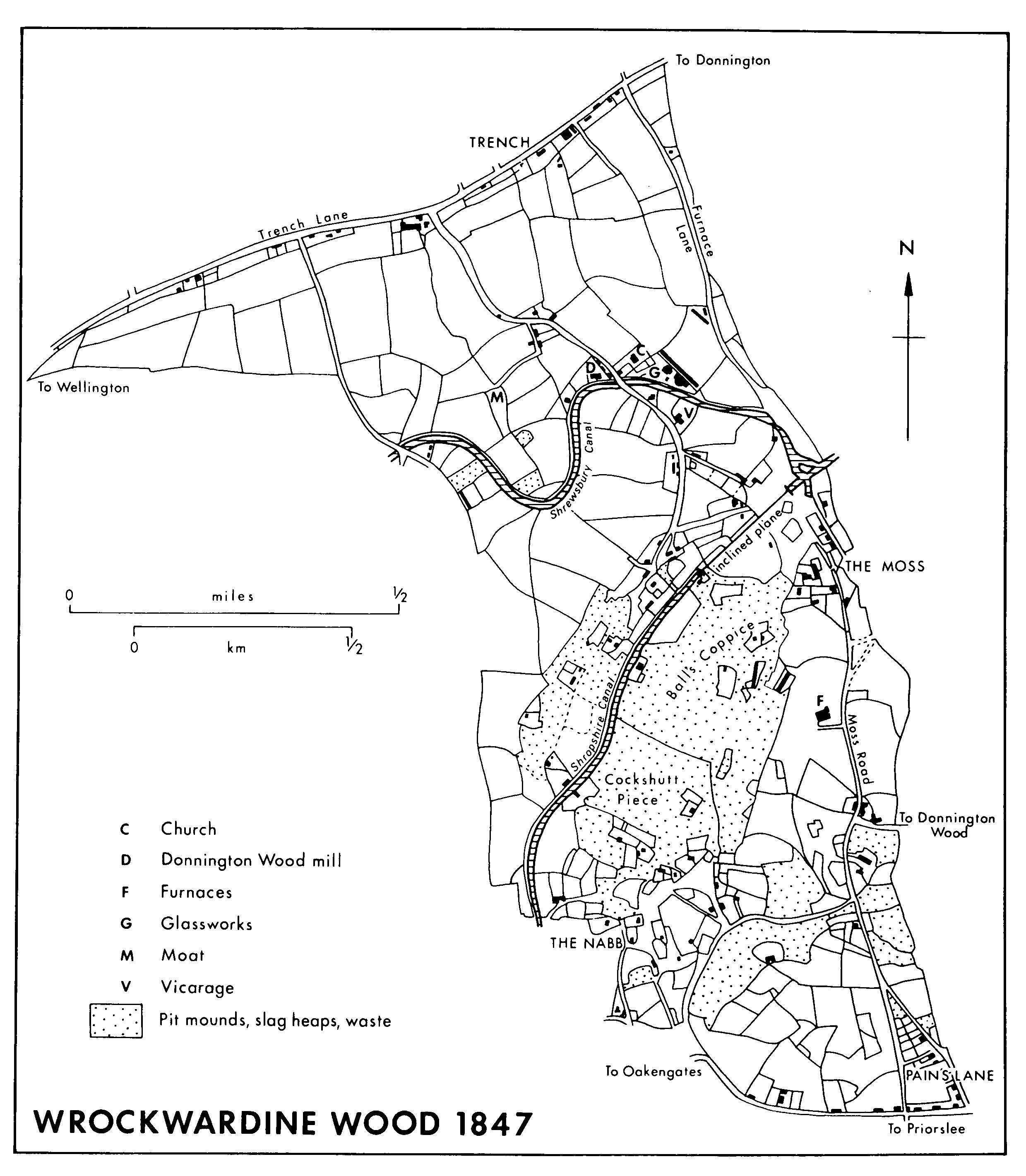
Wrockwardine Wood 1847
Two sprawling industrial settlements developed either side of Cockshutt Piece, apparently in the 18th century. At the Nabb scattered squatters' cottages were erected, to which some terraces, like Diamond Row, were added in the 19th century. At the Moss and around the church, there were, as well as squatter properties, some single-storeyed terraces, like Moss barracks, and some terraces of c. 1800, like Glasshouse Row.
Other early 19th-century terraces, like Bonser's Row and Bunter's Row, some of them speculatively built, were scattered elsewhere in the township south of the Wombridge Canal. (fn. 13) As elsewhere in the coalfield housing demand occasionally caused the conversion of industrial buildings to tenements. Wrockwardine Wood furnaces closed in the 1820s and were later made into 16 dwellings, and the glassworks into 10 dwellings in 1856. (fn. 14) Until the growth of St. George's in the 1850s there were few good quality artisans' dwellings in Wrockwardine Wood; most buildings were small and poorly constructed. They were, however, usually well spaced, and there were no concentrations of barrack dwellings similar to those in Donnington Wood. (fn. 15)
Lincoln Road and New Road, like St. George's, were laid out in the third quarter of the 19th century, short terraces again being the dominant form of housing.
After the First World War Oakengates urban district council built housing in the north-east corner of the township, the inner part of Woodhouse Crescent being finished in 1922. (fn. 16) Council houses were built in Gower Street to accommodate families cleared from slums under the 1930 Housing Act. (fn. 17) By 1946 the remainder of the Woodhouse Crescent estate was built, with the neighbouring Gibbons Road estate being added in the mid 1950s. (fn. 18) In the 1970s and early 1980s over 200 council dwellings were built at the south end of Moss Road and near St. George's in New Street and Gower Street. (fn. 19) Speculative building of the 1960s or early 1970s filled the area south of Trench Road around Teague's Bridge Lane. By 1973 a large area between Albion Street and the Nabb had been scheduled for private housing, (fn. 20) and building was in progress there in 1982.
In 1650, as well as 16 tenants occupying 14 holdings in the township, there were 35 cottagers, 12 of them at Pain's Lane. Sixteen householders paid hearth tax in 1672. (fn. 21) By 1817 the township had 1,938 inhabitants; 703 of them were receiving poor relief. (fn. 22) By 1841 population had fallen to 1,698, but it had risen to 2,099 by 1851, and in 1861 the figure was 3,317, an increase of 58 per cent over the decade. By 1871 it was 3,794, and over the next forty years population grew, though more slowly, to a peak of 5,276 in 1911. Thereafter it fell (fn. 23) perhaps for fifty years. (fn. 24) Between 1851 and 1861 the number of miners increased from 309 to 476, and that of ironworkers and engineers from 84 to 486. The number of pit bank girls rose too, from 63 to 128. Many of the new workers were immigrants from the more rural parts of the county: 90 per cent of the township's population was native to the coalfield in 1851, only 64 per cent in 1871. (fn. 25)
From the growth of mining and industry in the 17th century until the building of council and private housing estates in the 1960s and 1970s most of the township's inhabitants were employed in the local coal, iron, and steel works. The changing methods or fortunes of those industries directly affected the employees. In 1791 the introduction of a new system of regulating wages and hours by the Coalbrookdale partners led to riots at Coalpit Bank and Wrockwardine Wood. In 1816- 17, during the post-war depression, 36 per cent of the inhabitants received poor relief, (fn. 26) and in 1931 the old-fashioned New Yard works closed with the loss of 1,000 jobs. (fn. 27)
Apart from Watling Street and Trench Road, turnpiked in 1726 and 1763, (fn. 28) and probably what were known by the 19th century as Teague's Bridge Lane, Church Road, and Furnace Lane, all roads in the township seem to be later than the 17th-century expansion of mining.
The Wombridge Canal, probably completed in 1788, and the Shropshire Canal, completed c. 1793, crossed Wrockwardine Wood and met on its eastern boundary. About 1794 the Wombridge Canal was linked to the new Shrewsbury Canal. An inclined plane on the Shropshire Canal rose 122 ft. in 320 yd. from the junction to a summit level on Cockshutt Piece. The Shropshire Canal closed in 1857, the Shrewsbury c. 1921. (fn. 29) An underground level, perhaps navigable, ran between Donnington Wood furnaces and the area north-west of the Nabb by c. 1800. (fn. 30)
There were horse-drawn railways in the township in the mid 19th century. The Coalbrookdale partners were authorized to build one c. 1758, just west of what became Furnace Lane. (fn. 31) Others ran towards Donnington Wood furnaces from the township's western boundary (fn. 32) and from east of the Nabb. (fn. 33) In 1851 the Lilleshall Co. began to replace the old railways with a private standard-gauge network, which linked most of the company's interests by 1855. The network reached its peak during the First World War when 26 miles of track carried 1½ million tons of goods a year. It linked with the G.W.R. line at Oakengates and the L.N.W.R. line at Donnington. The system closed in 1959. (fn. 34)
Until the later 19th century social life apparently centred on alehouse and chapel. About 1650 nine people were presented for selling ale in Wrockwardine Wood. (fn. 35) In the mid 18th century up to seven alehouse keepers were licensed in Trench, a settlement only partly in the township, and up to five in the rest of the township. (fn. 36) There were eight public houses and seven beer sellers in 1856. By the later 19th century there were up to 14 beer sellers but the number of public houses had remained fairly constant. (fn. 37)
Cockpit yard at the Moss was mentioned in 1802. (fn. 38)
The Gentleman's Club of Pain's Lane, begun for senior Lilleshall Co. employees in 1812, met monthly on Saturday evenings in the Shaw Birch or the King's Arms public houses, Trench Lane. Sick benefit and death grants were withheld from those afflicted as a result of fighting, drunkenness, or venereal disease. (fn. 39) In 1840 a friendly society began to meet at the White Horse inn. (fn. 40) In 1843 there was a school clothing society and a missionary society, in 1844 a general clothing society. (fn. 41) In 1871-2 there were two lodges of Odd Fellows (Manchester Unity) in Trench: 'Miners' Glory' with 21 members, 'Marquis of Stafford' with 270. (fn. 42) Several friendly societies existed in 1904. (fn. 43)
Much of the local welfare provision was by the Lilleshall Co. for its employees. A soup kitchen, opened in 1878, excluded Lilleshall Co. employees as they were fed by the company at the New Yard. (fn. 44) A dining room provided in 1900 for workers at the New Yard was available after work for 'socials'. About the same time the company bought the Bird in Hand public house at the Nabb 'to safeguard the workers' beer'. (fn. 45)
In 1875 a reading room and library opened in Matthews Buildings under the auspices of the rector and others. (fn. 46) There was a Wrockwardine Wood Liberal Association in 1885, a Liberal and Labour Club in 1917. (fn. 47)
Wrockwardine Wood was said to have had one of the earliest professional football clubs in the country, playing first on Wade's field (later Wade Road) and later on the White Horse field, where by 1974 there was a licensed clubhouse. Trench Athletic also enjoyed considerable success in the early 20th century, playing on the Shawbirch field, at times against teams like Aston Villa reserves. (fn. 48) Wrockwardine Wood Bowling Club was formed in 1922 with a green on the White Horse field. The Nabb Bowling Club was formed in the same year, when part of an old pit mound was levelled and grassed. (fn. 49) The Trench and District Electric Theatre was open in 1917, in the building known as Trench Billiard Hall in 1937 and 1941. (fn. 50) The Regent cinema, Wrockwardine Wood, popularly known as the 'Ranch House', opened in 1946 and closed c. 1958. (fn. 51) With the designation of Telford new town in 1968 and the subsequent housing developments within the parish the range of social facilities increased. In 1982 Trench Road community centre, the Oakengates Leisure Centre (opened 1974), and a social centre for the unemployed were in use, and schools' facilities were increasingly available for public use out of school hours. (fn. 52)