A History of the County of Sussex: Volume 6 Part 2, Bramber Rape (North-Western Part) Including Horsham. Originally published by Victoria County History, London, 1986.
This free content was digitised by double rekeying. All rights reserved.
A P Baggs, C R J Currie, C R Elrington, S M Keeling, A M Rowland, 'West Grinstead', in A History of the County of Sussex: Volume 6 Part 2, Bramber Rape (North-Western Part) Including Horsham, ed. T P Hudson (London, 1986), British History Online https://www.british-history.ac.uk/vch/sussex/vol6/pt2/pp83-89 [accessed 30 April 2025].
A P Baggs, C R J Currie, C R Elrington, S M Keeling, A M Rowland, 'West Grinstead', in A History of the County of Sussex: Volume 6 Part 2, Bramber Rape (North-Western Part) Including Horsham. Edited by T P Hudson (London, 1986), British History Online, accessed April 30, 2025, https://www.british-history.ac.uk/vch/sussex/vol6/pt2/pp83-89.
A P Baggs, C R J Currie, C R Elrington, S M Keeling, A M Rowland. "West Grinstead". A History of the County of Sussex: Volume 6 Part 2, Bramber Rape (North-Western Part) Including Horsham. Ed. T P Hudson (London, 1986), British History Online. Web. 30 April 2025. https://www.british-history.ac.uk/vch/sussex/vol6/pt2/pp83-89.
WEST GRINSTEAD
The parish of West Grinstead, (fn. 1) which includes the growing village of Partridge Green, and which is noted for its long Roman Catholic tradition, lies midway between Horsham and the north slope of the South Downs. Though the distinguishing prefix is recorded from the mid 13th century, (fn. 2) the parish has no connexion with East Grinstead. (fn. 3) The ancient parish contained 6,720 a. in 1881. Between 1882 and 1891 a detached part of Ashurst within West Grinstead containing Upper Posbrooks Farm (37 a.) was added to it. In 1971 the parish comprised 2,733 ha. (6,753 a.). (fn. 4) The parish is irregular in shape, especially on the south side where Ashurst parish makes a deep salient within it. In the south-east the boundary is formed by the two branches of the river Adur, which join at the parish's south-eastern tip. In the north and west the boundary partly follows streams. Elsewhere it follows what are evidently old roads: that from Partridge Green to Nuthurst in the northeast, and that from Bramber to Knepp castle and Horsham in the south-west and north-west. (fn. 5) Windsor common in the north-east corner of Wiston parish perhaps originally straddled the boundary between Wiston and West Grinstead. (fn. 6)
The highest land in the parish, between 100 and c. 160 ft. (30 and 49 metres), is in the north-east, north-west, and south-west parts. The western branch of the river Adur flows from north-west to south-east across the parish and is fed by tributary streams from both sides. The parish lies chiefly on the Weald clay, with alluvium in the valleys, and there are outcrops of Horsham stone and other sandstone beds in the extreme north and north-east. (fn. 7) The river Adur was subject to serious flooding in 1797, (fn. 8) and continued to be so during the 19th and 20th centuries despite the improvement of its banks after 1807. (fn. 9) It was tidal in both branches in the south-east corner of the parish in 1984. (fn. 10) In the Middle Ages much of the parish was presumably covered by woodland. By 1830, however, woods, hedgerows, and shaws were estimated to comprise less than a sixth of its area, (fn. 11) and in 1983 the parish was much less wooded than the surrounding country to north and south. The Lock estate included c. 228 a. of woods in 1984. (fn. 12) Jolesfield common and Partridge green in the east remained uninclosed waste until 1872. (fn. 13)
Parkland has been extensive in the parish since the Middle Ages. The two chief parks, Stock park in the west, recorded between the 13th century and the 16th or 17th, and the park attached to West Grinstead manor house, recorded between the 16th century or earlier and the 20th, are discussed below. (fn. 14) In addition, the new gentlemen's houses built after c. 1800 often had parkland attached, (fn. 15) and there was parkland in the parish belonging to Shermanbury Grange by 1896; in 1982 it still adjoined Partridge Green village on the east. Parkland and park-like farmland were dominant in the landscape in the mid 20th century; in 1965 West Grinstead and Shipley together were described as 'the Weald ... tamed, then let back, on a leash as it were, to be wild within limits'. (fn. 16)
Early medieval settlement in West Grinstead, as elsewhere in the Weald, was scattered. Some sites originated as pasture places for manors in the south part of Bramber rape, (fn. 17) while the farm name Bowshots contains the element scydd which describes huts built as the seasonal dwellings of herdsmen. (fn. 18)
The name Grinstead was recorded as the hundred name in 1086, (fn. 19) and was apparently transferred later to the vill and the parish. The surname 'of Grinstead' occurs locally c. 1230. (fn. 20) A vill of Grinstead was mentioned c. 1260, (fn. 21) but there is no evidence for a nucleated village. The only dwellings known to have existed near the church are Glebe House to the east (fn. 22) and two buildings that stood beside the churchyard, one of which was used as a shop in the 17th and 18th centuries; (fn. 23) the manor house lay 2/3 mile (1 km.) to the north. Glebe Cottage, on the north side of the churchyard, is apparently a 17th-century building, with exposed timber framing in its northern outshut. The symmetrical south front with end chimneys was added in the 18th century; at the same time, apparently, the plan of the house was altered to give a central staircase flanked by two rooms. A one storeyed red brick range running north-south was built on the north-east side in the 19th century to serve as a school; (fn. 24) originally separate, it was later joined to the house. The main range was extended eastwards in the 20th century, when various fittings brought from elsewhere were inserted in the house, and the shell hood was added over the entrance doorway. Across the river south of the church are Fosters, a timber-framed building apparently of the 17th century or earlier, with a possibly 18th-century brick barn to the south, and Butcher's Row, a group of 19th-and 20th-century estate cottages. (fn. 25) The other vill recorded in the Middle Ages was Byne, which lay partly in West Grinstead and partly in Ashurst; (fn. 26) again, no nucleated settlement can be shown to have existed there in West Grinstead.
The sites of some medieval farms can perhaps be inferred from modern farm names corresponding to medieval surnames recorded in the parish; examples are Chuck's, Fuller's, Hobshort's, Lloyts, Need's, Posbrook's, Thistleworth, and Tuckmans farms. (fn. 27) Pinland farm was also recorded before 1500; (fn. 28) it, Hobshort's, Thistleworth, and Brightham's farms all occupy knolls, like many others in the Weald clay country. Many isolated farmhouses in the parish are of the 17th century or earlier, (fn. 29) and many that are post-medieval may occupy the sites of earlier buildings. Well Land Farm north of Partridge Green is a four-bayed hall house with crown-post roof; into the hall were inserted first a smoke bay, and then a central chimney. Rookland Farm east of Dial Post includes a three-bayed medieval range, probably a cross wing to an earlier house now destroyed. Sand's Farm nearby and Tuckmans Farm in the north-west corner of the parish are basically 16th-century, but the former has a medieval cross wing. (fn. 30) Lloyts Farm, probably of the early 17th century, is a timberframed house of three-room plan with a slightly later rear kitchen wing. (fn. 31)
In the 18th and 19th centuries many new houses were built along the main roads of the parish, benefiting from their improvement under turnpike trusts after 1764. (fn. 32) The chief areas of settlement at that time were the three adjacent hamlets in the east, Jolesfield, Littleworth, and Partridge Green, and the hamlet of Dial Post in the west. (fn. 33)
A tenement called Jolesfield existed in 1590, (fn. 34) and Jolesfield was a road destination in 1535 and 1635. (fn. 35) Some farmhouses of the 17th century and earlier surround what was uninclosed common land until 1872. (fn. 36) Blanches, near the south-east corner of the former common, is a late medieval house of four bays with a two-bayed central hall. In the late 16th or early 17th century an upper floor was inserted into the hall and a chimneystack added on the rear wall. The two-storeyed oriel on the front of the building is 17th-century, but may represent an older form. At Joles Farm, south of the common, the probably 16th-century main range also had a central open hall of two bays; by c. 1600 an upper floor had been inserted and the south end remodelled, two external brick chimneystacks being built.
At least one building described as a cottage existed on or beside the common in the early 18th century; (fn. 37) surviving buildings at Jolesfield of the 18th and early 19th centuries include the old Green Man inn at the south-west corner and buildings on the north side which housed workers at the Jolesfield brickworks. (fn. 38) About 1840 there were 15 or 20 buildings around the common. (fn. 39) The hamlet of Littleworth lay at the north-east corner of the common along the road to Nuthurst; some buildings of before c. 1800 survived there in 1983. (fn. 40) One or two other buildings were put up at Littleworth before c. 1840. (fn. 41)
About ½ mile (800 metres) south of Jolesfield common, houses began to spring up by the 18th century beside Partridge green, a strip of waste land along the road which leads from the Horsham-Steyning road to Shermanbury and which became Partridge Green High Street. (fn. 42) By c. 1800 there was a group near the junction of the two roads, besides other buildings both south of that junction and east of the green towards the Shermanbury boundary. (fn. 43) Some 18thcentury or earlier buildings survived in all three places in 1983.
Building continued at Partridge Green in the earlier 19th century, (fn. 44) and by c. 1840 there were c. 6 buildings at the road junction, including an inn. (fn. 45) The settlement expanded much faster after the arrival of the railway in 1861 and the inclosure of the green in 1872. (fn. 46) Shortly before 1867 some new cottages were built by small proprietors near the station; having two bedrooms they were superior to the general standard of cottages elsewhere in the parish at the time. (fn. 47) Some grander Italianate stuccoed houses in South Street off High Street are contemporary. Further houses had been built in both streets by 1896, and by 1909 there was building along most of High Street between the Horsham-Steyning road and the edge of the park belonging to Shermanbury Grange. Building land was offered for sale north of High Street in 1907 and 1911; at the latter date there was claimed to be a good demand in the area for houses and cottages of moderate size. (fn. 48)
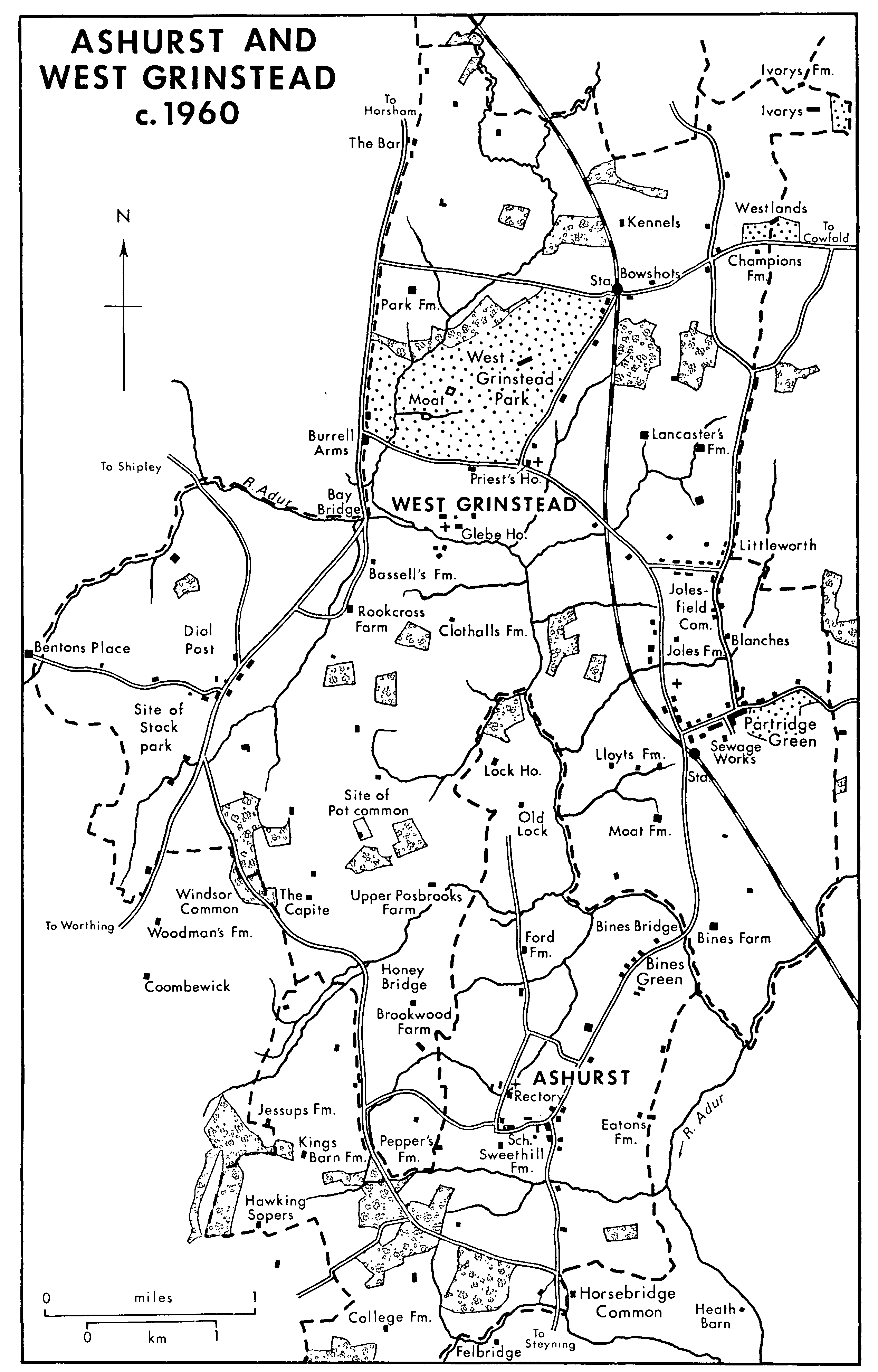
Ashurstn And West Grinstead c. 1960
Building land at Jolesfield common was offered for sale in 1861 and later, (fn. 49) but despite the provision of new, straight roads at the inclosure of the common in 1872, only a few more houses were built there before the First World War, one being the new Green Man inn. (fn. 50) There was more building in the mid 20th century, especially after c. 1966, (fn. 51) at all three hamlets, particularly at Partridge Green. Many houses and bungalows were built north of Partridge Green High Street, and much new housing was put up east of Littleworth Lane, including some council houses; at the same time the former brickworks south of High Street were built over. (fn. 52) Detached houses and bungalows were meanwhile built at the north-east corner of the former Jolesfield common as a southern extension of Littleworth hamlet. By the late 1970s Partridge Green had become the centre of population in the parish, a dormitory suburb with a continual turnover of residents. (fn. 53)
The hamlet of Dial Post occupies a knoll of land on the Horsham–Worthing road in the west part of the parish. The explanation of its name is uncertain, (fn. 54) but Dial Post farm, Dial Post fields, and Dial Post house were named in the early 18th century. (fn. 55) The name Dial Post was applied later to the settlement which grew up along the road during the 18th and 19th centuries (fn. 56) and which in the early 19th was called a small village. (fn. 57) Dial Post House, dated 1712, (fn. 58) has an 18th-century brick front. At least three other buildings are timber-framed. (fn. 59) By c. 1840 there were eight or ten houses in the hamlet, (fn. 60) including an early 19th-century villa at the north end. After c. 1920 some council houses were built on the north side and new houses and bungalows to the south and west. In 1974 the hamlet's population was said to be 230. (fn. 61)
Two smaller hamlets grew up during the same period on the Horsham–Worthing road further north, both straddling the parish boundary. At or near the junction with the road to Partridge Green by the later 19th century were a group of buildings including the Burrell Arms inn and a post office; all were demolished when the main road was widened c. 1965. (fn. 62) The hamlet called the Bar in the northwest, (fn. 63) however, survived in 1982, when there were a pair of low, probably 17th-century, weatherboarded cottages, some brick cottages apparently of the 18th or earlier 19th century, and one larger stuccoed 19thcentury house along the road to Copsale in Nuthurst; other houses nearby in Shipley parish had, however, disappeared. (fn. 64) Little Tuckmans, further north, is a three-bayed hall house with later alterations. (fn. 65)
Many other houses were built outside the hamlets in the 20th century, but the idea aired in 1920 of developing land for building near West Grinstead station was not taken up. (fn. 66) The 19th and 20th centuries have also seen the building of larger houses or the conversion of older ones as gentlemen's residences. Dial Post House was offered for sale as such in 1811, (fn. 67) and Champions Farm in the north-east corner was said to be capable of improvement in 1838. (fn. 68) On both occasions the plentiful game of the neighbourhood was suggested as an attraction to purchasers, a theme that recurred later. (fn. 69) Large houses built in the 19th century included West Grinstead Lodge of before 1832, (fn. 70) near the modern Roman Catholic church, and Jolesfield House, which existed by 1874 south-west of Jolesfield common. (fn. 71) In the north-east corner of the parish the adjacent Westlands and Belmoredean occupied a southfacing ridge with fine views; (fn. 72) Westlands, originally a Gothic building of c. 1830, (fn. 73) was later rebuilt. (fn. 74) The Capite in the south-west part of the parish was built in the late 19th or earlier 20th century in revived vernacular style, but was remodelled on a grand scale in early 19th-century classical style in 1972. (fn. 75) Seven gentlemen's families were listed in the parish in 1852, 11 in 1874, and 34 in 1938. (fn. 76) Though West Grinstead remained a parish of scattered settlement in 1983, several isolated farmhouses were demolished after c. 1875, viz. Haven, Goreland, Denman's, and Whiteson Farms. (fn. 77)
Thirty-one persons were taxed in West Grinstead tithing in 1296, 24 in 1327, and 38 in 1332, but some of them apparently lived in Nuthurst parish. (fn. 78) In the vill of Byne, which lay partly in West Grinstead and partly in Ashurst, 25 persons were taxed in 1296, 17 in 1327, and 29 in 1332. (fn. 79) In 1378 twenty-three persons were assessed in each tithing, (fn. 80) and in 1524 West Grinstead had 41 taxpayers, Byne 31. (fn. 81) In 1642 the protestation was subscribed by 179 adult males, and in 1724 c. 106 families were recorded. (fn. 82) From 939 in 1801 the population rose steadily, despite temporary setbacks in the 1830s and 1890s, to 1,252 in 1851, 1,582 in 1891, 1,751 in 1961, and 2,579 in 1981. (fn. 83)
Two chief north–south roads formerly passed through the parish; both are evidently old, since both are followed in part by the parish boundary, and both evidently served as drove roads for seasonal transhumance. That on the west led from Bramber and Steyning to Knepp castle in Shipley by way of Ashurst, Pot common, and Rookcross Farm; (fn. 84) its age is also indicated by its well-worn character, while the name Rookcross, recorded by 1538, seems to refer to either a road junction or a medieval wayside cross. (fn. 85) The northern continuation of the road towards Horsham by way of Copsale in Nuthurst was mentioned in 1605, (fn. 86) and was called Bar Lane c. 1875; it was perhaps that road for the repair of which money was left in 1606. (fn. 87) Bay Bridge, by which the road from Steyning and Bramber crossed the river Adur, existed by 1605, (fn. 88) and was rebuilt or repaired in 1675. (fn. 89) Honey Bridge, by which it crossed a tributary of the Adur further south, existed in 1538 (fn. 90) and possibly earlier, (fn. 91) taking its name from the nearby estate which belonged to Durford abbey; (fn. 92) in the earlier 18th century its repair was charged on the occupiers of certain neighbouring lands in West Grinstead, Ashington, and Wiston. (fn. 93) Most of the southern part of the road was a footpath in 1983. A branch road from Rookcross Farm to Dial Post and Ashington existed in 1724. (fn. 94)
In the east another road from Steyning and Ashurst led by way of Bines Bridge, Partridge green, and Jolesfield common northwards to Nuthurst and Horsham. Bines Bridge existed by 1535; (fn. 95) its repair was enjoined on the tenants of Bidlington Kingsbarns manor in 1544 and 1728, (fn. 96) and it was ordered to be rebuilt in 1825 by the Baybridge Canal Co. (fn. 97) The bridge is continued on its south-west side in Ashurst parish by a causeway. The road was considered a major one in 1724. (fn. 98)
What may have been another north-south route, between the two mentioned, led across the river Adur by West Grinstead church and then, changing direction, through and beside West Grinstead park. Stone flags of the 19th century or earlier survived in the sections north and south of the river in 1983. (fn. 99) The road may have been that which led from West Grinstead church to Nuthurst in 1488, (fn. 100) and also the road to London which bounded West Grinstead park in the 1550s. (fn. 101) The section alongside the park had its modern name Park Lane by 1764. (fn. 102)
A road from near Knepp castle to Jolesfield, presumably the modern one, was mentioned in 1635. (fn. 103) A route from Clothalls Farm to Slaughter Bridge in Shipley, possibly following the roads called Clothalls and Bassell's lanes in 1875, was mentioned in 1511. (fn. 104)
The Horsham–Steyning turnpike road was opened through the parish under an Act of 1764, following existing roads: the modern Horsham–Worthing road as far as a point north of Knepp castle, the road from that point to Jolesfield, and the road leading from Jolesfield to Ashurst by way of Partridge green and Bines Bridge. The turnpike was financed largely from the subscriptions of Merrik Burrell, lord of West Grinstead manor, and another. A horse road leading east–west across West Grinstead park was closed under the Act. (fn. 105) The turnpike was one of the main roads to Brighton in the late 18th century. (fn. 106) A branch turnpike road from Partridge green to Shermanbury, also following an existing route, was authorized under an Act of 1771. (fn. 107) The road from north of Knepp castle to Worthing was turnpiked under an Act of 1802. (fn. 108) Its route originally followed existing roads by way of Rookcross Farm and Dial Post, the section north of Rookcross Farm being called Baybridge Lane or Baybridge Hill in the earlier 19th century. (fn. 109) The straight section of road which bypasses Rookcross Farm was cut by or soon after 1823. (fn. 110) Coaches and wagons to Worthing were using the new turnpike in 1811. (fn. 111) A fourth turnpike road through the parish was the entirely new one from Buck Barn on the Horsham–Worthing road to Cowfold, promoted by Sir Charles Burrell of Knepp Castle in Shipley to provide a link with his family estates in Cuckfield. (fn. 112) Authorized in 1825, (fn. 113) it was described in 1835, together with the section continuing westward through Shipley, as the most convenient east–west route through the Weald. (fn. 114) The Horsham–Steyning turnpike road of 1764 was disturnpiked in 1885, (fn. 115) the Partridge Green to Shermanbury road in 1877, (fn. 116) the Worthing road in 1878, (fn. 117) and the Buck Barn to Cowfold road in 1876. (fn. 118) Much of the Horsham–Worthing road through the parish was made a dual carriageway c. 1965. (fn. 119)
A motor bus service between Horsham and Steyning plied via Nuthurst and Partridge Green in 1933. About 1979, when there was a less frequent service, the southern destination was Henfield; at the same date Dial Post on the Horsham–Worthing road was much better served by buses. (fn. 120)
The river Adur formerly provided an alternative means of communication to roads; in the mid 18th century, for instance, it was used to bring building stone for use at West Grinstead manor house. (fn. 121) The demesne farm of Eatons manor in Ashurst and Henfield is said to have included a wharf in West Grinstead in 1687. (fn. 122) Under an Act of 1807 the river was improved as far as Bines Bridge. (fn. 123) A wharf below the bridge had been constructed by 1811, (fn. 124) for the import of lime, chalk, and coal; (fn. 125) the wharf basin survived in 1982. The next section upstream, from Bines Bridge to Bay Bridge on the Horsham– Worthing road, was improved by the Baybridge Canal Co. under an Act of 1825 which was promoted by members of the Burrell family among others. (fn. 126) By 1830 that section of the river had been widened and straightened in parts, (fn. 127) two locks constructed, and a wharf made at Bay Bridge; (fn. 128) already by that date traffic had increased, (fn. 129) and in 1833–4 coal, sea sand, gravel, and salt were being brought upstream, and timber taken downstream, in boats belonging to Sir Charles Burrell of Knepp Castle and Henry Michell the Horsham brewer among others. Horsham was a chief destination for goods coming in, (fn. 130) and in 1835 if not earlier the Bines Bridge wharf was Michell's property. (fn. 131) Business greatly declined after the opening of the Horsham–Shoreham railway in 1861, and in 1875 the company was wound up and the navigation abandoned, (fn. 132) though coal and chalk were still brought to Bay Bridge c. 1890. (fn. 133) The wharf basin at Bay Bridge was overgrown in 1982, but some timber piles of the wharf itself survived, (fn. 134) as did the two locks, one near Old Lock in Ashurst and the other west of West Grinstead church; (fn. 135) a swing bridge near Hatterell Farm had been removed in the 1960s. (fn. 136)
The Horsham–Shoreham railway line was opened through the parish in 1861, with a station called West Grinstead on the Buck Barn to Cowfold road and another at Partridge Green. (fn. 137) The line was closed in 1966, (fn. 138) and most of it was used as a bridleway in 1983.
An alehouse in the parish was recorded in 1623. (fn. 139) The Roebuck inn mentioned in 1773 stood alongside the modern Horsham–Worthing road in the north-west corner of the parish, and was known as the halfway house between Horsham and Steyning. (fn. 140) There was a public house further south on the same road at Bay Bridge in the 1780s; (fn. 141) it seems still to have existed in the early 19th century. (fn. 142) The Burrell Arms inn at the junction of the Horsham–Worthing road with the turnpike road to Partridge Green existed in 1808, (fn. 143) and in 1814 was described as a hotel. (fn. 144) In the later 19th century or earlier 20th it was the place for holding both the Burrell estate rent audits and doctors' surgeries. (fn. 145) The inn was closed by 1962, (fn. 146) the building, which was stuccoed and of three bays and two storeys, (fn. 147) being demolished soon afterwards when the Horsham–Worthing road was made a dual carriageway. The Hare and Hounds inn at Partridge Green was one place of meeting for the West Grinstead hundred court between 1786 and 1802. (fn. 148) It was replaced between 1866 and 1874 by a new building called the Station inn (later hotel); (fn. 149) in 1887 it was described as a family and commercial hotel. (fn. 150) After the closure of the railway in 1966 it was renamed the Partridge. The old Green Man inn at the south-west corner of Jolesfield common was used for vestry meetings in 1787. (fn. 151) After the inclosure of the common it was replaced by a new building nearer the road, (fn. 152) which was still an inn in 1982, when the old building also survived. Other inns in the parish, all of which survived in 1982, were the Tabby Cat at West Grinstead station (fl. 1866), at which horses and carriages could be hired in 1887, the Crown at Dial Post, recorded from 1874, and the Windmill at Littleworth, which existed in 1909 and possibly earlier, (fn. 153) and which was the meeting place of a 'slate club' in 1916. (fn. 154)
Bull baiting was apparently carried on at the old Green Man inn in the late 18th or early 19th century. (fn. 155) A West Grinstead, Ashurst, and Shipley cricket team existed in 1802. (fn. 156) Jolesfield, later Partridge Green, cricket club was founded in 1882. At first it played at the recreation ground on Jolesfield common allotted at the inclosure of 1872. By 1907, however, it was using the cricket ground at Shermanbury Grange east of Partridge Green. The club still flourished in 1983. In the early 20th century there was also a 'gentlemen's' team at West Grinstead Park. The Shermanbury Grange ground was bought by the parish council in 1939 as the King George V playing field and continued to be used in 1982. (fn. 157) Stoolball and football have also been played at Partridge Green. There was a tennis club in 1982. (fn. 158) Bines Bridge was a resort of anglers in 1907 (fn. 159) and 1982. Kennels for the Crawley and Horsham Hunt were built north of West Grinstead station c. 1877. (fn. 160) In the 20th century the Tabby Cat inn by the station was a meeting place for hunt followers. (fn. 161)
There was a lending library in the parish in 1867. (fn. 162) A working men's club existed at Jolesfield after 1890, using the iron mission room which had preceded St. Michael's church, Partridge Green. (fn. 163) A St. Joseph's social club on the north side of Jolesfield common was mentioned between 1907 and 1913, (fn. 164) and a men's institute between 1913 and 1938. (fn. 165) Partridge Green village hall in High Street was built in 1904 in memory of Col. Forester Britten of Shermanbury Grange. The parish council took over its management in 1970, and the building was extended in 1975. (fn. 166) A wooden village hall at Dial Post was opened c. 1934; (fn. 167) c. 1979 it was in poor condition and little used. In 1982 there were many clubs and societies at Partridge Green, including a choral society and a drama group, and one or two at Dial Post. (fn. 168)
A penny-post receiving-house at the Burrell Arms inn was authorized in 1808. (fn. 169) In 1867 sources of water in the parish were poor, consisting chiefly of ponds. (fn. 170) The Partridge Green Water Co. existed in 1914 and 1923; about the latter date it obtained all its water from the Steyning and District Waterworks Co. (fn. 171) There was a reservoir south-east of Littleworth in 1896 and later. (fn. 172) A system of sewage disposal at Partridge Green was installed c. 1907, and between 1908 and 1920 was being managed by a 'Partridge drainage committee', apparently of the parish council. (fn. 173) A sewage works south of Partridge Green was recorded from 1909 (fn. 174) and survived in 1982. An electricity supply for Partridge Green was proposed in 1928, (fn. 175) but gas had not been brought to the village by 1982. (fn. 176) The fire station at Partridge Green was built c. 1961. (fn. 177)
A Roman Catholic priory was founded east of Priest's House in 1869. (fn. 178) There were 36 nuns in 1871, (fn. 179) when it was called St. Juliana's priory. In 1876 it was taken over by three Dominican sisters from Paris. (fn. 180) Before their arrival an 'industrial school' for poor children, making coconut matting, had been set up. (fn. 181) Over several years the number of children attending it grew to 18, and the school was thereupon given the title of orphanage, and amalgamated with a refuge for 20 girls which the Dominican sisters were running in the convent. The orphanage later ceased to take girls, but retained its 'industrial' character in training boys for trades. In 1893 the convent and attached orphanage formed a large barrack-like block of buildings east of the new Roman Catholic church; the convent had 50 cells, and the orphanage could accommodate 200 boys. (fn. 182) The orphanage was called St. Joseph's in 1903 and St. Mary's between 1909 and 1922; (fn. 183) between 1904 and 1918 it was managed, and greatly improved, by the parish priest. (fn. 184) The priory ceased to exist, and the orphanage was closed, in 1932 or 1933. (fn. 185)
In 1935 the St. Thomas More Approved school for boys was established in the buildings of both convent and orphanage. Later it was reorganized as a community home under the Children and Young Persons Act, 1969. In 1970 there were places for 90 boys aged between 11 and 15. From 1935 to 1977 the institution was staffed by Presentation Brothers, but afterwards it was under lay control. (fn. 186)
A house in Park Lane was used as a convalescent home for c. 12 patients between 1891 and 1905 or later. (fn. 187) Eder farm in the south-west corner of the parish was used from c. 1949 until its sale c. 1971 as a centre for the agricultural education of young Jews intending to work in kibbutzim in Israel. (fn. 188)
A husbandman of West Grinstead was pardoned for his part in Cade's rebellion in 1450. (fn. 189)
Alexander Pope (d. 1744) was a great friend and correspondent of his fellow Catholic John Caryll of West Grinstead manor house (d. 1736), who suggested the composition of The Rape of the Lock (1712). Though Pope visited the house at least once, (fn. 190) there is no evidence that the incident which gave rise to the poem occurred at West Grinstead, (fn. 191) nor that the poem was composed under the oak tree in West Grinstead park which was made the subject of a tree preservation order in 1951. (fn. 192) E. W. Hornung (d. 1921), author of Raffles, and brother of J. P. Hornung of West Grinstead Park, lived at Partridge Green. (fn. 193) Hilaire Belloc (d. 1953) is buried in the churchyard of the Roman Catholic church, as is the writer Antonia White (d. 1980).