A History of the County of Sussex: Volume 6 Part 3, Bramber Rape (North-Eastern Part) Including Crawley New Town. Originally published by Victoria County History, London, 1987.
This free content was digitised by double rekeying. All rights reserved.
A P Baggs, C R J Currie, C R Elrington, S M Keeling, A M Rowland, 'Upper Beeding', in A History of the County of Sussex: Volume 6 Part 3, Bramber Rape (North-Eastern Part) Including Crawley New Town, ed. T P Hudson (London, 1987), British History Online https://www.british-history.ac.uk/vch/sussex/vol6/pt3/pp29-34 [accessed 3 May 2025].
A P Baggs, C R J Currie, C R Elrington, S M Keeling, A M Rowland, 'Upper Beeding', in A History of the County of Sussex: Volume 6 Part 3, Bramber Rape (North-Eastern Part) Including Crawley New Town. Edited by T P Hudson (London, 1987), British History Online, accessed May 3, 2025, https://www.british-history.ac.uk/vch/sussex/vol6/pt3/pp29-34.
A P Baggs, C R J Currie, C R Elrington, S M Keeling, A M Rowland. "Upper Beeding". A History of the County of Sussex: Volume 6 Part 3, Bramber Rape (North-Eastern Part) Including Crawley New Town. Ed. T P Hudson (London, 1987), British History Online. Web. 3 May 2025. https://www.british-history.ac.uk/vch/sussex/vol6/pt3/pp29-34.
UPPER BEEDING
UPPER Beeding, which contained the medieval Sele priory, straddles the river Adur c. 4 miles (6.4 km.) from its mouth at Shoreham, (fn. 1) and is c. 3 miles (4.8 km.) long by 2½ miles (4 km.) wide at its widest point. In the Middle Ages, when the parish was called Beeding or, more usually, Sele, (fn. 2) it included a large detached portion c. 11 miles to the north in the Weald near Horsham. The two areas were separate for poor-law purposes by the 17th century. (fn. 3) In 1838 most of the Wealden portion was separated for ecclesiastical purposes and made the parish of Lower Beeding; its northern part, however, called Bewbush tithing, remained part of Upper Beeding ecclesiastical parish until 1871. (fn. 4) Upper Beeding in 1881 comprised 3,895 a. excluding Bewbush. In 1883 a detached part (79 a.) of Henfield that lay within the parish was added to it. In 1933 a similar island (3½ a.) of Steyning, called Spratt's Marsh, was added, as was the entire civil parish of Edburton (1,094 a.) to the east. In 1971 therefore Upper Beeding contained 5,071 a. (2,052 ha.). (fn. 5) The present article excludes the histories of Lower Beeding, including Bewbush, and Edburton, which are treated elsewhere.
The western boundary follows the modern course of the Adur in the south and part of what was apparently the course of the medieval main channel of the river further north. (fn. 6) The north-western portion of the parish beyond the river comprises the former tithing of King's Barns, the area later called King's Barn. The northern boundary makes a salient to include Hoe wood, formerly Old wood, which was part of Stretham manor in Henfield. (fn. 7)
The relief and underlying geology of Upper Beeding are very varied. (fn. 8) Much of the southern part lies on the Chalk of the South Downs, once largely open sheep pasture, which also provided a site for holding a muster of Lewes and Bramber rapes in 1625 and for a gibbet in the 1840s. (fn. 9) Since the 18th century most of the downland has been turned over to arable, while in the 20th very large excavations have been made at cement works in the south-west. Windmill Hill, 192 ft. high, which lies east of the village, is separated from the rest of the Chalk by the Henfield road. North of the Chalk, outcrops of sandstone provided sites of settlement at King's Barn, Horton, Tottington, and Small Dole, while the Gault clay outcrop between them was the site from the 18th century of most of the relatively little woodland in the parish. (fn. 10) Further sites for settlement were provided by the Valley Gravel outcrops along the river, on which lie Upper Beeding church and Beeding Court, the former manor house, with the modern Upper Beeding village between them.
The river Adur has always been important, for its effect on the landscape of the parish, as a means of communication, and in providing employment. Sometimes it was called the Beeding river or water, (fn. 11) and on one occasion Horton river. (fn. 12) In the early Middle Ages it formed a wide estuary between Bramber castle, King's Barn, and Wyckham (in Steyning) on the west and Upper Beeding church and Horton Hall on the east; much sea shingle is said once to have been visible at King's Barn, and in the 11th century Steyning had a thriving port. (fn. 13) In the Middle Ages salt was extracted from tidal marshland within the parish. (fn. 14) Later, as in other parishes of the Adur valley, land was gradually reclaimed. In 1349, for instance, a parcel of 6 a. of meadow, evidently in the former estuary, was said to be often flooded, and another parcel of land was described in 1368 as having been consumed by the sea. (fn. 15) Both common and several marsh was apparently mentioned in 1384, (fn. 16) and an embankment in 1535. (fn. 17) By the early 18th century there was a 'wall' on the east bank for at least a mile north of Beeding bridge; that it had been built fairly recently is suggested by the name 'the new brooks' given in 1733 to land north of the church. (fn. 18) Under the 1807 Adur navigation Act embankments were completed throughout the parish, (fn. 19) and in the 19th and early 20th centuries the brookland provided excellent fattening pasture. (fn. 20) Extreme weather conditions, however, could lead to flooding well into the 20th century. (fn. 21)
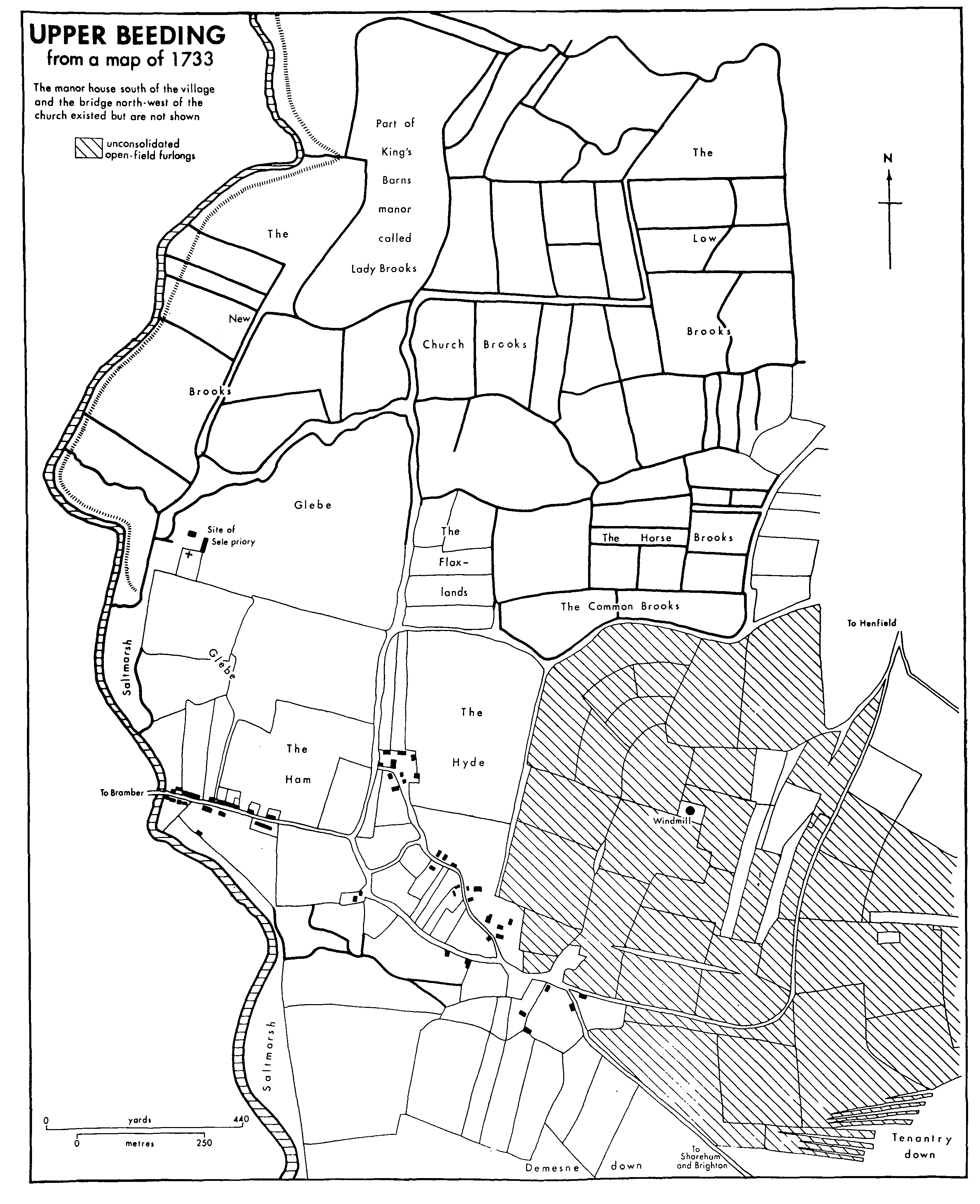
Upper Beeding from a map of 1733
There was a wagon ford across the river in the north end of the parish in 1806, (fn. 22) and the river was still fordable on foot at low tide opposite Beeding Court in 1981. (fn. 23)
The original site of the village seems to have been between the church and Castle Town, along the major route that led from the river crossing at King's Barn to the summit of Beeding Hill. (fn. 24) It is likely that the church was built where a settlement already existed, and though there is no documentary evidence for houses nearby, apart from Sele priory and its successor the rectory house, nevertheless house foundations are said to have been traced to the southeast near the supposed line of the road. (fn. 25) Moreover, that line is continued further south-eastwards by Hyde Street, (fn. 26) where several 17th- or 18th-century buildings survive, including Oak Cottage, Old Place, the Old House, the biggest house in the street, and Hobjoins, formerly Hobjohn's Farm. Building materials used there, as elsewhere in the parish, are flint, brick, and timber, with roof coverings of tile, thatch, or Horsham stone. South of Hyde Street beside the road to Henfield is Valerie Manor, the former New House, which is of flint and brick construction and has a main north-south range with a short west wing; surviving original woodwork is of high quality and suggests an early 17th-century date, and there is a date 1668 above a ground-floor fireplace.
The modern main street of the village (fn. 27) lies along the causeway leading towards Bramber, which was built only in the late 11th century, but which thereafter apparently attracted settlement away from its earlier site in the parish, in the same way that it did at Steyning. (fn. 28) There were buildings east of Beeding bridge by the 13th century, when the street was already called High Street. (fn. 29) One possibly 16thcentury building, of timber-framed construction with arched braces, survives on the south side, and there are three houses on the north side of the 17th century or earlier. Several other buildings are 18thcentury; some are low and of flint, a few having datestones, not necessarily trustworthy, and there are two grander houses: the Manor House, on the north side, of five bays, since altered, and the red brick Pond Farmhouse, on the south side, of three bays. By the end of the 18th century the western half of the street was fully built up on both sides with 12 or 15 houses. (fn. 30)
Beeding Court, the main manor house of the parish, lies ¼ mile south of High Street, on a site which strangely, until the valley road to Shoreham was built in the early 19th century, was accessible by land only from the east. (fn. 31) It may, however, have been linked with a settlement further south for which there is archaeological evidence from the 12th to the 14th century, (fn. 32) and which was possibly the place in Burbeach hundred called Old Bridge: the name was recorded apparently near Beeding Court in 1439, (fn. 33) a field or furlong called Bridgeways south-east of Beeding Court was named in 1842, (fn. 34) and representatives of taxpayers recorded there in 1296 occur in 1327 in Beeding vill, including the lady of Beeding manor. (fn. 35)
The other main medieval settlements lay on the west and east sides of the parish. King's Barns, an Anglo-Saxon or earlier settlement west of the river Adur, was still called a separate tithing c. 1840, (fn. 36) and was linked more closely to Steyning parish than to Upper Beeding: the lands belonging to the tenants of King's Barns manor lay partly in Steyning, and the home farm in 1822 had pasture rights on the common fields and downs of Steyning, not Upper Beeding. (fn. 37) The east part of the parish was divided between the manors of Horton and Tottington, which each lay north-south across it, separated by the long strip of land which formed a detached part of Henfield. (fn. 38) The name Horton, or 'dirty farm', (fn. 39) presumably described the adjacent clay lands belonging to the manor. Horton was called a vill in the mid 13th century, when the surname 'of Horton' was common in the area, (fn. 40) was taxed separately in the early 14th, (fn. 41) and was a separate tithing in 1488. (fn. 42) In 1558 reference was made to the poor of Beeding and Horton, as if there were still two settlements. (fn. 43) Horton Farmhouse, formerly Upper Horton Farm, has a low timber-framed back range of the 17th century or earlier and a tall three-bayed front range faced with beach pebbles with red brick dressings and a mansard roof. (fn. 44) At Tottington, on the other hand, there is no evidence of a hamlet, (fn. 45) all the tenements of the manor in the 17th century and later lying outside the parish.
After c. 1800 there was much building in the parish, the number of houses more than doubling in the first half of the 19th century and then increasing by more than half in the second. (fn. 46) In 1842 High Street had c. 25 houses in its western half. (fn. 47) Various buildings there are of the 19th and early 20th centuries, including two cement-rendered terraces, and there are two contemporary terraces in Church Lane. Further houses had also been built in or near Hyde Street by 1896. Meanwhile in the 1880s and 1890s an increasing number of parishioners, presumably mostly newcomers, were listed as 'private residents'. (fn. 48) During the 1920s and 1930s the eastern end of High Street was built up, and small detached houses and bungalows were built in Church Lane and between it and Hyde Lane, while east of Hyde Street a few houses were built along Manor and College roads. After the Second World War most of the area between High Street, Hyde Lane, and the church was filled with houses, including a council estate south of the church built by 1957, while east of Hyde Street building continued on a large scale into the 1970s, including some council houses. There was also building south of High Street by 1975. In 1981 there were over 200 council houses in Upper Beeding. (fn. 49)
Outside the village some houses had been built at Castle Town by 1808, (fn. 50) including one that survived in 1981, of cobbles with red brick dressings. Scattered houses had appeared there by the 1870s, and in 1895 residents included a basket maker and a shopkeeper. (fn. 51) The two long terraces of brick houses called Dacre Gardens on the east side of the Shoreham road were built as company housing for employees of the cement works between 1896 and 1909. (fn. 52) Detached houses and bungalows were built east of Castle Town on the south side of the Henfield road during the 20th century. Twentieth-century houses and bungalows were also built south-east of Horton Hall on the Henfield road and south of the village on the Shoreham road.
Small Dole on the Henfield border was mentioned as a road destination c. 1530. (fn. 53) In 1808 a group of cottages stood west of the road facing 'Dole green' on the east; (fn. 54) one apparently early 19th-century building survived there in 1984. A wheelwright and a blacksmith lived at Small Dole in 1874. (fn. 55) Some more buildings were built before 1896 when there was a post office there. In the mid 20th century many houses were built to the north across the stream, partly in Upper Beeding and partly in Henfield. By c. 1979 the population of the hamlet was said to be nearly 400, (fn. 56) but residents felt closer links with Henfield than with Upper Beeding. (fn. 57)
Meanwhile, west of the river, the proximity of Steyning railway station had encouraged the development for building of land south and south-west of King's Barn Farm after c. 1900. Some houses had been built immediately east of the railway by 1909. By 1932 there were houses along most of King's Barn Lane besides some to the south, while other roads had been laid out but not built on. By 1939 Castle Way, most of Roman Road, and the north part of King's Stone Avenue had been built up, and by 1957 the entire area between King's Barn Lane, King's Stone Avenue, and the railway. That area looked much more to Steyning than to Upper Beeding, and in 1980 its transfer to Steyning parish was being considered. (fn. 58)
In 1086 the 110 tenants of Beeding manor and the 78 tenants of what were later to be King's Barns and Bidlington manors evidently included many living outside the area that became the parish. At the same date 10 tenants were recorded at Tottington manor and 3 at an unnamed sub-manor of it. (fn. 59) In 1327 thirty-six people were assessed to the subsidy in Beeding tithing, and 13 or possibly 15 at Horton. The parallel totals of those paying the poll tax in 1378 were 66 and 23, and of those paying the 1524 subsidy 27 and 10. (fn. 60) Fifty-two houses were listed in Beeding tithing in 1664 and 14 in Horton. (fn. 61) The total of 71 adult males who took the protestation in 1642 presumably excludes inhabitants of Lower Beeding, (fn. 62) who, however, are likely to have been included in the high figure of 206 communicants recorded in 1676. (fn. 63) In 1775 the population of Upper Beeding alone was computed by the curate at c. 370. (fn. 64) From 459 in 1801 it rose to 614 by 1841, growth being especially rapid in the 1820s. The total remained between 500 and 625 until 1901, after which it rose rapidly. In the first decade of the new century the population increased by nearly half, and between 1931 and 1951 it nearly doubled, from 1,103 to 2,175, though part of the latter increase was due to the extension of the boundary in 1933. There was a further rapid rise from 2,396 in 1961 to 3,903 in 1971. In 1981 the population was 4,385. (fn. 65)
The chief road through the parish in past centuries was that forming part of the great east-west route through southern England from Canterbury to Southampton, which ran along the crest of the South Downs from the east towards the river Adur. (fn. 66) It seems originally to have crossed the river by two routes. One crossing was apparently between Botolphs and a point south of Beeding Court, the existence of a bridge or causeway, though there is no archaeological evidence to confirm it, being implied by the place name Old Bridge, used both as an alternative name for Botolphs itself and to describe apparently a lost settlement on the east side of the river. (fn. 67) The second route apparently followed Hyde Street, which is partly a hollow-way, and passed the church to cross the river towards King's Barn, on the way to Steyning. (fn. 68) A bridge called New bridge formed the crossing point in 1724 and 1806, (fn. 69) and was presumably the same as the old wooden bridge which was there in 1905. (fn. 70) It was replaced soon afterwards by an iron bridge which in 1951 was called the White bridge. (fn. 71) Both river crossings mentioned were evidently eclipsed by the new bridge and causeway at Bramber built in the late 11th century.
Two other important roads passed through the parish in the Middle Ages. One was the road between Steyning and Shoreham, which crossed Bramber bridge, ascended Beeding Hill, and continued southwards past New Erringham in Old Shoreham parish. (fn. 72) The other led northwards through the west part of the parish to link Bramber castle with Knepp castle in Shipley by way of King's Barn and of Greenfields and Nash Farm in Steyning. (fn. 73) In 1803 part of it was called Vauxhall Lane, (fn. 74) though the reason for the name is not clear. The road eastwards along the foot of the downs between Horton and Edburton may also have existed in the Middle Ages, and was used by Richard Pococke to approach the village in 1754. (fn. 75) What is apparently an old track on the north side of Windmill Hill east of the village connected that road with Upper Beeding church and the river crossing towards King's Barn, and an alternative route lay over Windmill Hill. (fn. 76) The road from Horton northwards to Henfield and Cowfold existed by 1560. (fn. 77)
Both the ancient road along the crest of the downs and its branch to Shoreham continued to be used by travellers in the 18th century since they were drier than alternative lower-lying routes. (fn. 78) Upper Beeding's position as a traffic node is indicated in the early 18th century by the many references to 'travellers' in the parish registers. (fn. 79) Other downland routes of importance during the same period were that from Horton to Shoreham (fn. 80) and that from Beeding Hill to Portslade; the latter may have been used in Roman times, (fn. 81) was the future Charles II's escape route to Brighton in 1651, (fn. 82) and in the 18th century served as an alternative approach to that rapidly growing resort. (fn. 83) The road from Steyning to the top of Beeding Hill was turnpiked after 1764. (fn. 84) Under an Act of 1807, however, a new turnpike road was built along the Adur valley from Upper Beeding to Old Shoreham, the carriage road over Beeding Hill being closed and the road from Horton to Shoreham also being stopped up; the occupier of Beeding Court was exempted from paying tolls. (fn. 85) The tollhouse in Upper Beeding built at that date was removed before 1974 to the Open Air Museum at Singleton near Chichester. (fn. 86) The Steyning, Upper Beeding, and Shoreham road was disturnpiked in 1885. (fn. 87)
Post-medieval arrangements for the upkeep of Beeding bridge are discussed elsewhere. (fn. 88)
In 1922 the village was connected by frequent motor buses with Brighton, Shoreham, Petworth, Worthing, and Portsmouth. (fn. 89) In 1976 there were frequent bus services to the first two of those places, and also to Steyning, Storrington, and Henfield. (fn. 90) A bypass road for Steyning, Bramber, and Upper Beeding, partly following the line of the closed railway, was opened in 1981, (fn. 91) joining the Beeding- Shoreham road at a roundabout.
The river too served as a means of communication. In 1540 Upper Beeding may have been an entrepôt for the transport of Horsham stone from the Weald to be used at West Tarring church. (fn. 92) A bargeman of Beeding was mentioned in 1758, (fn. 93) and in 1775 seven or eight parishioners were said to earn their living by barging. (fn. 94) Nine barges were listed in the parish in 1803, (fn. 95) a bargemaster and 8 bargemen were recorded in 1851, (fn. 96) and there was still a boat owner in 1895. (fn. 97) In 1842 a malthouse and a coal pen lay north of Beeding bridge and a coalshed, stables, and a wharf south of the bridge. (fn. 98) The wharf survived in 1875 (fn. 99) and a coal dealer was recorded in the parish in the previous year. (fn. 100) Already by 1814 the river had been used to distribute lime from kilns on the site of the modern cement works. (fn. 101) In the early 20th century clay for the cement works was barged downstream from Horton, providing the only toll income then enjoyed by the Adur navigation trustees. (fn. 102)
The Horsham-Shoreham railway, opened in 1861, passed through the north-west corner of the parish, which was served by its stations at Steyning and Bramber. It was closed in 1966, except for its southern section from Shoreham which continued to be used to transport cement from the cement works. (fn. 103)
An unlicensed alehouse in Beeding parish, probably in Upper Beeding, was mentioned in 1647, (fn. 104) an inn in 1686, (fn. 105) and innkeepers in 1706 and 1715. (fn. 106) The King's Head existed by 1788, meetings of the Burbeach hundred court being held there between that date and 1811. (fn. 107) In the 1820s and later it was also the place for holding the vestry. (fn. 108) The Fox and Hounds at Small Dole was mentioned in 1845, the Rising Sun, formerly the Star, in 1851, and the Bridge inn in 1913. (fn. 109) All four inns survived in 1981.
A lending library was provided by private donation at the Sunday school founded in 1831, but is not heard of after 1833. (fn. 110) J. R. Bloxam, vicar 1862- 91, organized various cultural activities in the village, often at the school: lectures, for instance on astronomy, penny readings from 1874, and concerts in the 1880s. (fn. 111) The village hall in High Street for Upper Beeding and Bramber was built in 1930, when a Bramber and Beeding village club met there. (fn. 112) The recreation ground north of High Street was opened c. 1950. (fn. 113) A village hall at Small Dole founded c. 1911 (fn. 114) was later closed; c. 1980 the former Baptist chapel there was converted into another. (fn. 115) A horticultural society flourished at Small Dole in 1959, (fn. 116) and various societies and clubs at both Small Dole and Upper Beeding in 1981, when the cement works also provided many social and sporting facilities for its employees. (fn. 117)
Upper Beeding's nearness to Steyning brought it public services earlier than most villages. A thriceweekly post existed in 1799 and was restarted in 1810. (fn. 118) Gas lighting had been installed by c. 1888. (fn. 119) The Steyning and District Waterworks Co. sank a well on the downs south-east of the village c. 1898 and built a reservoir nearby; it was empowered from the first to supply the village, and certainly did so by 1928. (fn. 120) At Small Dole, however, water for most houses in 1916 had to be brought from some distance. (fn. 121) The Steyning Electric Light Co. was authorized to supply Upper Beeding with electricity in 1921. (fn. 122)
Fourteen inhabitants of Beeding parish had the county franchise in 1705. (fn. 123) In 1779, however, there were said to be no resident gentry in Upper Beeding except the Backshell family of New House, the modern Valerie Manor. (fn. 124) The chief landowners of the parish remained absentees a century later. (fn. 125) In 1651 the future Charles II passed through Upper Beeding in his flight to France, but did not stop although New House was offered to him for the purpose. (fn. 126)