A History of the County of Somerset: Volume 6, Andersfield, Cannington, and North Petherton Hundreds (Bridgwater and Neighbouring Parishes). Originally published by Victoria County History, London, 1992.
This free content was digitised by double rekeying. All rights reserved.
A P Baggs, M C Siraut, 'Bridgwater', in A History of the County of Somerset: Volume 6, Andersfield, Cannington, and North Petherton Hundreds (Bridgwater and Neighbouring Parishes), ed. R W Dunning, C R Elrington (London, 1992), British History Online https://www.british-history.ac.uk/vch/som/vol6/pp192-206 [accessed 30 April 2025].
A P Baggs, M C Siraut, 'Bridgwater', in A History of the County of Somerset: Volume 6, Andersfield, Cannington, and North Petherton Hundreds (Bridgwater and Neighbouring Parishes). Edited by R W Dunning, C R Elrington (London, 1992), British History Online, accessed April 30, 2025, https://www.british-history.ac.uk/vch/som/vol6/pp192-206.
A P Baggs, M C Siraut. "Bridgwater". A History of the County of Somerset: Volume 6, Andersfield, Cannington, and North Petherton Hundreds (Bridgwater and Neighbouring Parishes). Ed. R W Dunning, C R Elrington (London, 1992), British History Online. Web. 30 April 2025. https://www.british-history.ac.uk/vch/som/vol6/pp192-206.
In this section
BRIDGWATER
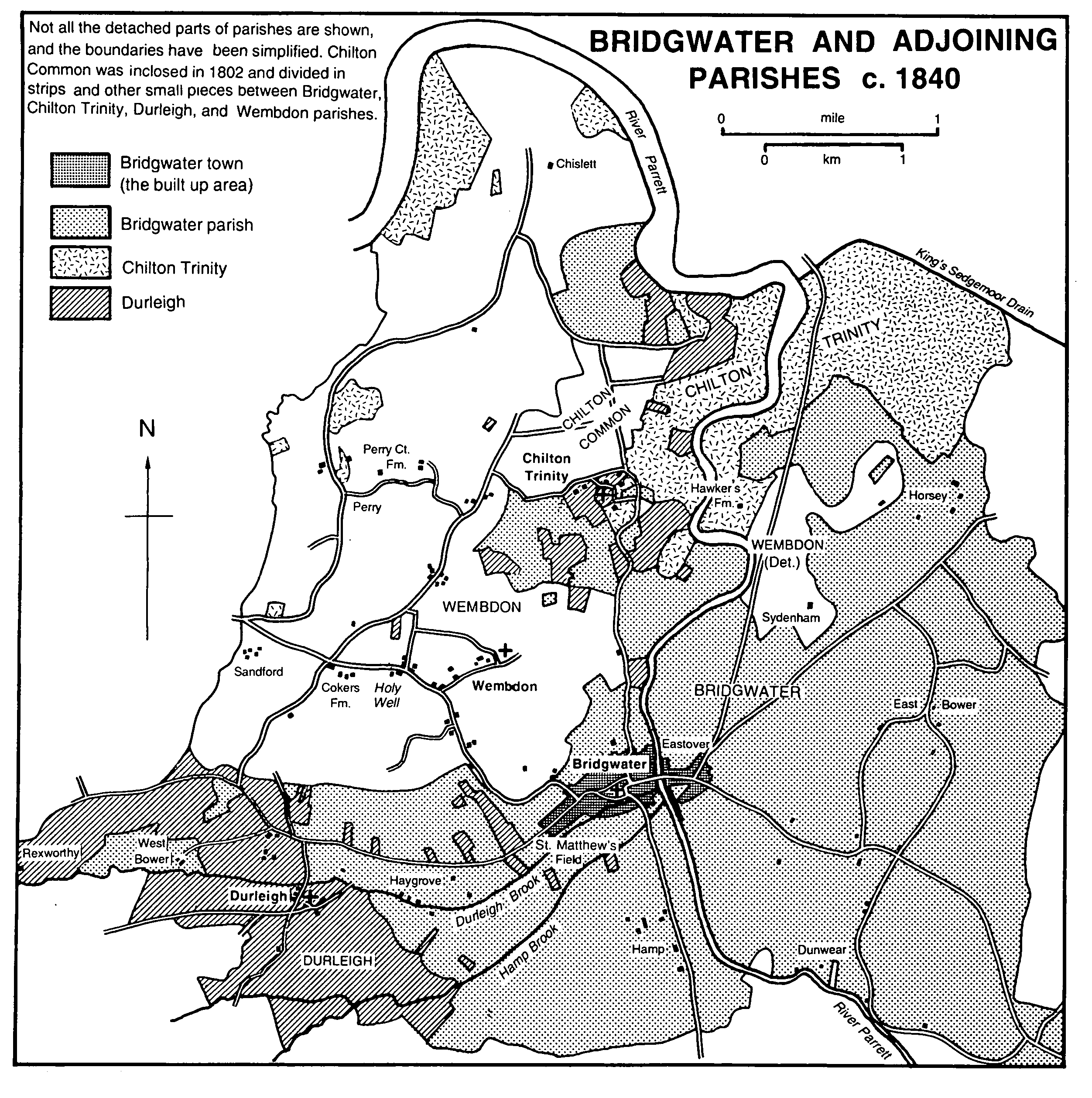
Bridgwater and adjoining parishes c.1840
The borough and port of Bridgwater lies in an irregularly shaped parish through which flows the tidal river Parrett. (fn. 1) It lies c. 18 km. by water from Bridgwater Bay. The first element of the name, commonly thought to refer to a bridge built by the Domesday lord Walter of Douai, (fn. 2) is more likely to be derived either from the Old Norse bryggja, meaning a quay or jetty, or from the Old English brycg, a gang plank between ship and shore. (fn. 3) Bridgwater, apparently agricultural at Domesday, (fn. 4) had developed into a town by 1200. A castle was built soon after that date and near its south-eastern corner a bridge crossed the Parrett. Four gates marked the principal entrances to the town. The parish included in the 11th century the secondary settlements of Hamp in the south, Haygrove and West Bower in the west, the latter in a detached part of the parish, Horsey in the north-east, East and North Bower in the east, and Dunwear in the southeast. Horsey, its name suggesting an island, (fn. 5) Haygrove, and Hamp were probably nucleated hamlets around a single farm; the Bowers were perhaps isolated dwellings. Dunwear was a scattered riverside settlement occupying much of the east bank of the Parrett.
The boundaries of the ancient parish, which measures at its widest 6 km. from east to west and 4.5 km. from north to south, suggest that Wembdon, Chilton Trinity, Durleigh, and Bridgwater had formed a single unit, and in 1086 Bridgwater, Horsey, Bower, and Wembdon were part of the estate held by Walter of Douai. (fn. 6) North of the town the boundaries either curve to suggest earlier watercourses or interlock in such a way as to imply that the Parrett may have had several channels and that intercommoning resulted on ground permanently recovered from the tidal marsh. The eastern boundary, with Bawdrip and Chedzoy, in part follows natural watercourses and in part a causeway named Park or Port Wall, created by a drainage scheme before the late 18th century. A small stretch of the southern boundary follows the Parrett, but near the hamlet of Somerset Bridge an incursion of North Petherton parish across the river, named Old River Ground, was evidently the result of natural or deliberate straightening. (fn. 7) Another part of the southern boundary, also with North Petherton, was evidently formed across Stock moor when the area was inclosed. The boundary with Durleigh partly follows streams, and that with Wembdon was marked by the northern edge of the former Queen's wood. (fn. 8) West Bower, beyond Durleigh to the west, was divided into two small, irregular areas. After transfers of land to all six adjoining areas, including West Bower to Durleigh, in 1886-7, the area of the parish was 3,967 a. in 1891. (fn. 9) The civil parish of Bridgwater Without, including Dunwear, East Bower, Chedzoy Lane, and Haygrove, was created in 1894. (fn. 10)
East of the river the parish is on low-lying alluvium c. 6 metres above sea level nearest the river and 12 metres on the north-eastern boundary at Horsey. West of the river alluvium runs across Stock moor in the south and along the Durleigh brook between Hamp and the town, both of which lie on ridges of marl, the highest point of which was occupied by Bridgwater castle. Bridgwater's marl has two small areas of terrace deposits (fn. 11) of valley gravel, which were used by the 16th century and until the 18th for building work and streets. (fn. 12) Sand was dug on the ridge in 1393-4 (fn. 13) Lime was dug in the south-east corner of the town near the 'quay above the bridge' in the 17th and 18th centuries, (fn. 14) and a kiln was in operation near Lyme Bridge by 1497. (fn. 15)
Communications
The construction of Bridgwater Bridge c. 1200 (fn. 16) and pontage levied on its users indicate the importance of the east-west river crossing, and routes both east and south of the town over low-lying marshes had to be causewayed. East of the town from 1286 there was a causeway running north from St. John's hospital to the Poldens (fn. 17) and indulgences were offered in 1326 to encourage its repair. (fn. 18) It was known as the 'long causeway' in the 18th century. (fn. 19) A second causeway leading south beside the Parrett was repaired through bequests of a Taunton merchant and others from 1501, (fn. 20) and in 1622 a charge was made for use of the route. (fn. 21)
Both causeways were among the principal parish roads turnpiked in 1730, the one on the route to Taunton, the other carrying the main traffic for the east and north. The other roads turnpiked in 1730 were the Minehead route through Wembdon village, two routes to the Quantocks, and one to Langport across Sedgemoor. In 1829-30 the Taunton route was re-aligned, and a new Bristol road was built direct to Dunball in Puriton, avoiding Crandon bridge. (fn. 22) A new route to take through traffic away from the town centre was built in 1958, involving the construction of Blake Bridge. The local section of the M5 motorway, following the general routes of the railway and the Bristol road, was begun in 1971 and opened in 1973. (fn. 23)
Ships presumably discharged their cargoes on both sides of the Parrett after c. 1200. A quay, recorded in 1424, was probably then being faced and paved. (fn. 24) Another quay, on the west bank above the bridge, was made for inland traffic in 1488 and was later known as the Langport slip. (fn. 25) Old and new quays, also on the west bank, were mentioned in 1616. (fn. 26) The old quay was enlarged and repaired and work was done on Back Quay, the old Langport slip, between 1697 and 1701, and c. 1712 a new quay was built on the east bank. (fn. 27) 'Mr. Darby's new quay had been built on the west bank, north of the old quay, by c. 1730. (fn. 28) An Act of 1794 enabled further improvements. (fn. 29) In 1845 official quays were defined, measuring 717 ft. from the town bridge on the east side and 716 ft. on the west. In addition to the quays in 1845 were a dry dock on the east bank (fn. 30) and a large wet dock on the west which comprised an outer tidal basin and an inner dock. The whole dock, with a bascule bridge and a complicated system of sluices and culverts to scour the basin of river mud, was designed by Thomas Maddicks and opened in 1841. (fn. 31)
The port had no official customs house in 1565, (fn. 32) but c. 1724 the duke of Chandos was planning to build one which seems to have been finished in 1726. (fn. 33) It probably replaced an earlier building on the quay belonging to the corporation. (fn. 34) From the 16th century cuts were made to straighten the river Parrett. A meander in Hamp was isolated by a new channel in 1568. (fn. 35) Thereafter improvements, effected or only suggested, concerned the lower reaches of the river, but its course from Bridgwater Bridge upstream came under private Acts passed in 1673 and 1699 to improve the navigation to Taunton. (fn. 36)
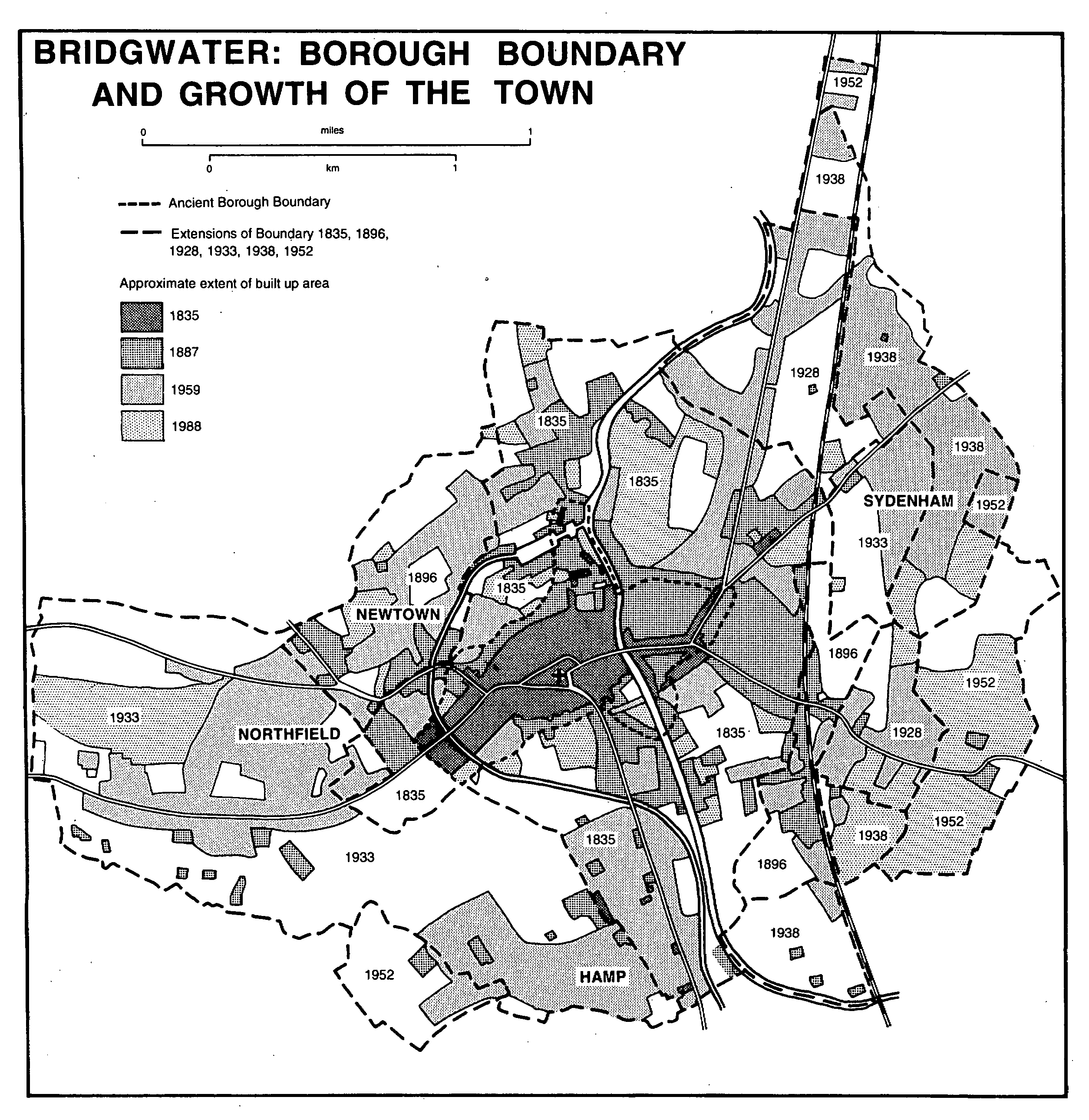
Bridgwater: borough boundary and growth of the town
The Bridgwater and Taunton canal, which from 1827 provided an alternative to the Tone and Parrett navigation, was extended from the terminating lock and basin at Huntworth in North Petherton parish by a loop west of Bridgwater which led to a large dock north of the town linked to the river by a tidal basin. (fn. 37) Extension and dock were opened in 1841. The canal ceased to be used commercially c. 1907, but the dock remained in use until 1971. In 1974 Somerset county council bought the dock and surrounding land. Associated buildings and machinery were subsequently restored and the dock converted to a marina. (fn. 38)
The Bristol-Exeter railway was opened as far as Bridgwater in 1841 and through the remainder of the parish to link with Taunton in 1842. (fn. 39) A branch from the railway station to wharves on the east bank of the Parrett was opened in 1845 as a horse tramway by Bridgwater corporation. From 1867 steam engines were used and from 1871 the line crossed the Parrett by a telescopic bridge to serve the docks, with branches to a pottery, a brewery, and other businesses. (fn. 40) The railway company opened extensive carriage works on the west side of the track south of the town in 1848. (fn. 41)
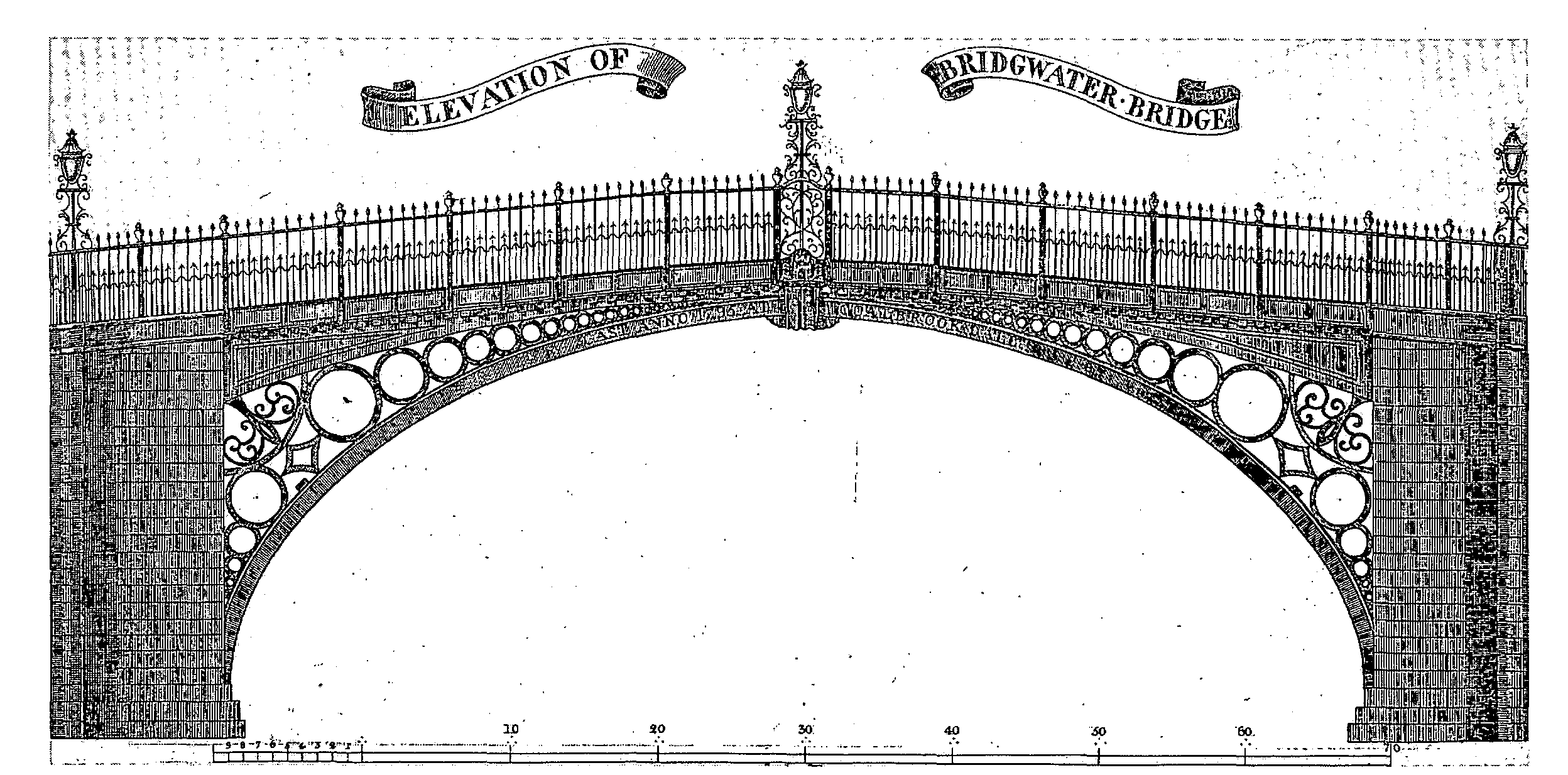
Elevation of Bridgwater Bridge, 1795
In 1890 the Bridgwater Railway Co. opened a single line linking the Somerset and Dorset line at Edington with Bridgwater North station. An adjoining goods depot included sidings serving a cattle dock and a brick and tile works and linked with the dock branch of the Bristol and Exeter line. The Edington line, operated by the Somerset and Dorset Joint Railway, was closed for passengers in 1952 and for freight in 1954. (fn. 42) Only the main-line station and line have remained open; the dock sidings have been removed and built over.
The grant of pontage to William Brewer in 1200 indicates that a bridge either already existed or was planned. Brewer was later remembered as the builder of the bridge. (fn. 43) In the later 13th century there was apparently a common fund to maintain the bridge, (fn. 44) known by 1286 as the great bridge. (fn. 45) Sir John Trivet gave 300 marks to rebuild the bridge in the 1390s, and work on it was in progress in 1399-1400. (fn. 46) There were houses on both the old and the new bridge. (fn. 47) In the 1480s tides and military vehicles damaged the bridge, (fn. 48) which was repaired in 1532 and 1678. (fn. 49) It was of stone, with three arches and cutwaters. By the end of the 18th century all the houses on it had been removed. (fn. 50) The medieval bridge was replaced by an iron one cast in 1795 at Coalbrookdale by Thomas Gregory and transported by water. It stood on masonry plinths and was virtually complete in October 1798. The old bridge was difficult to demolish and its piers were then still standing. The new bridge, with an elliptical arch pierced in Coalbrookdale's characteristic style, was topped by cast iron fencing over a 75-ft. span. Increasing traffic proved too heavy for the bridge, which was replaced by the present cast iron one, designed by R.C. Else and G.B. Laffan and made by George Moss of Liverpool, which was opened in 1883. (fn. 51)
Frog Lane bridge, named in 1344, may have taken the lane across the Durleigh brook as it entered the Parrett. (fn. 52) The south bridge, over the Durleigh brook outside the south gate, was called Lyme Bridge in 1373 and 1722. (fn. 53) The east bridge, taken up in 1646-7, may have crossed the former priory ditch at Eastover. (fn. 54) Horsemill Bridge, mentioned in 1694, may have taken the Taunton road across the Hamp brook, (fn. 55) and was perhaps the Hamp bridge, of brick, transferred in 1871-2 from the turnpike trustees to the county. (fn. 56)
Four bridges cross the Parrett besides the town bridge and the M5 motorway bridge. Somerset Bridge at Huntworth was designed by I.K. Brunel for the Bristol and Exeter Railway Co. It had a flat masonry arch which was partially demolished before completion in 1843 and was replaced in 1844 by a laminated timber arch. That bridge was replaced in 1904 by one of steel girders on the original masonry foundations. (fn. 57) North of the town bridge, the telescopic or Black Bridge was built in 1871 to take a railway across the river. It was steam-driven, retracting to allow shipping to pass upstream. The bridge, temporarily immobilized in 1942, was last opened in 1957, and from 1983 became part of a new road network. A few yards further north Chandos Bridge was opened in 1988. (fn. 58) South of the town bridge a partial town bypass crosses the river by Blake Bridge, opened in 1958. (fn. 59)
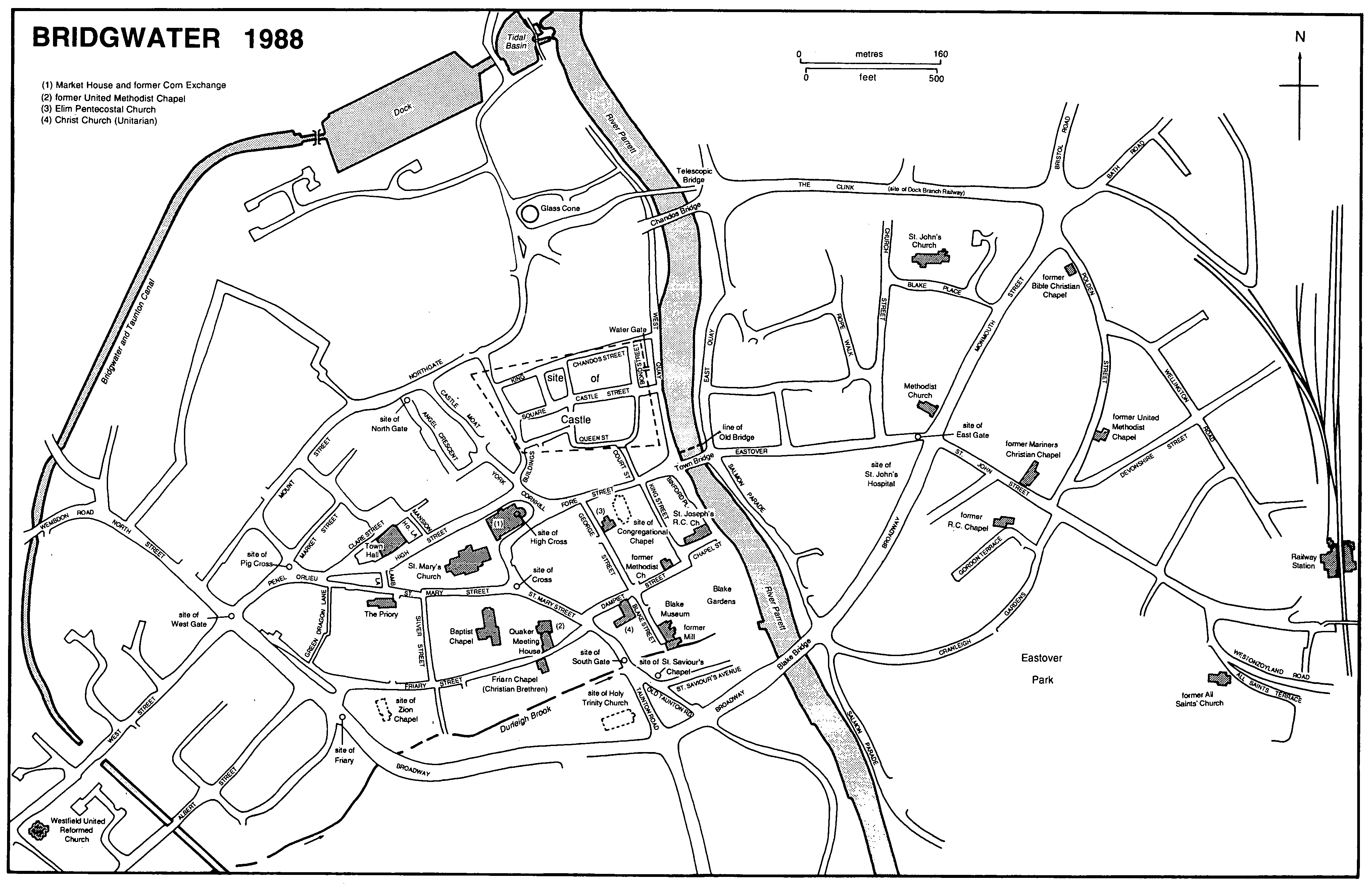
Bridgwater 1988
Land use
In 1086 there were 100 a. of underwood on Bridgwater manor and 3 a. on Hamp manor. (fn. 60) A small wood at Hamp survived in the mid 17th century. (fn. 61) The lord of Bridgwater was licensed in 1200 to enclose his wood, (fn. 62) and by 1234 part of the wood, west of the town, was a deerpark. (fn. 63) Timber, underwood, and bracken were sold from it until the early 15th century. (fn. 64) By 1635 it was known as Queen's wood. (fn. 65) There was only 10 a. of coppice and withy bed in the parish in 1847. (fn. 66)
By 1234 Bridgwater park provided livestock for North Petherton park (fn. 67) and meat for the royal household. (fn. 68) Part of the park was wooded and by 1413 was called Castle wood; the remainder was known as West park. (fn. 69) The park was mentioned in 1461 (fn. 70) but was then probably let for pasture. Three fields named Parks survived in Haygrove in 1847. (fn. 71)
Population
In 1327 the borough had 61 taxpayers, (fn. 72) and there were 858 payers of poll tax in 1377. (fn. 73) The population in 1444-5 has been estimated at c. 1,600, (fn. 74) but John Leland c. 1540 recorded the decay of more than 200 houses within living memory, (fn. 75) and there were 600 communicants in the parish in 1548 and a total of 352 households in 1563. (fn. 76) There were 642 males who signed the Protestation in 1641. (fn. 77) A census taken in 1695 suggested 2,200 or more inhabitants for the town and 600 for the rest of the parish. (fn. 78) In 1801 the total population was 3,634, and within ten years it had increased by over a quarter to 4,911. Increases of over one fifth followed in each of the next three decades, giving a total of 10,450 in 1841, which included 311 temporary labourers on the canal and railway and 92 in ships in the harbour. Thereafter for a time the annual increases were much smaller, the largest being over one tenth in the 1890s to a total of 14,900 in 1901. (fn. 79) Between 1901 and 1911 the total rose sharply to 17,981 but thereafter increases were smaller until 1951. In 1971 the total had risen to 22,691 and in 1981 to 23,323. (fn. 80)
The medieval town
The town's street pattern may have been based on a large, probably planned, central market place which became less prominent as the town developed as a port. The market place seems to have formed a large, roughly square area at the eastern end of the churchyard. Roads led into it from south, east, and west. At its north-eastern corner was the main entrance to the castle, which occupied that quarter of the town. Not far from the castle entrance stood the high cross. The market place probably extended as far south as the south-eastern corner of the churchyard, marked by St. Mary's Cross. (fn. 81) The name Cornchepyng or the Cornhill was in use for the market place in the mid 14th century. (fn. 82) Encroachments made on the south and west sides of the market place, significantly limiting the commercial area, perhaps caused shops and stalls to be moved to a street on the north side of the churchyard, called the great street by the mid 13th century and later High Street. (fn. 83)
By the mid 14th century High Street, wide enough to accommodate the market overflow from the town centre, was itself encroached upon by a long 'island' of shops and stalls in the vicus cocorum and known as Cokenrewe, and by the flesh and fish shambles, buildings which survived until the earlier 19th century. (fn. 84) The 'island' may also have included shops called Chapman Row and Ratyn Rew. (fn. 85) North of High Street was Orlove Street, and from its eastern end a street was formed by the mid 13th century following the line of the castle ditch northwards and known as North Street and later as Northgate Street. (fn. 86) The increase in business in the port enhanced the status of the street between the market place and the quay, which was known either as 'between church and bridge' or, as in 1367, Fore Street. By that date merchants had established themselves along its course, (fn. 87) their stalls perhaps sited along the edge of the castle moat.
High Street ran west from the Cornhill, converged with Orlove and St. Mary streets to form a triangular area, called the Orfair in 1399, and continued as Pynel Street to the west gate. (fn. 88) Both Pynel and Orlove seem to have been personal names. (fn. 89) Orlove Street (later Back Street) was called Clare Street in the 20th century, Pynel Street (later Prickett's Lane) was called Market Street, and the junction with High Street and St. Mary Street was called Penel Orlieu. (fn. 90)
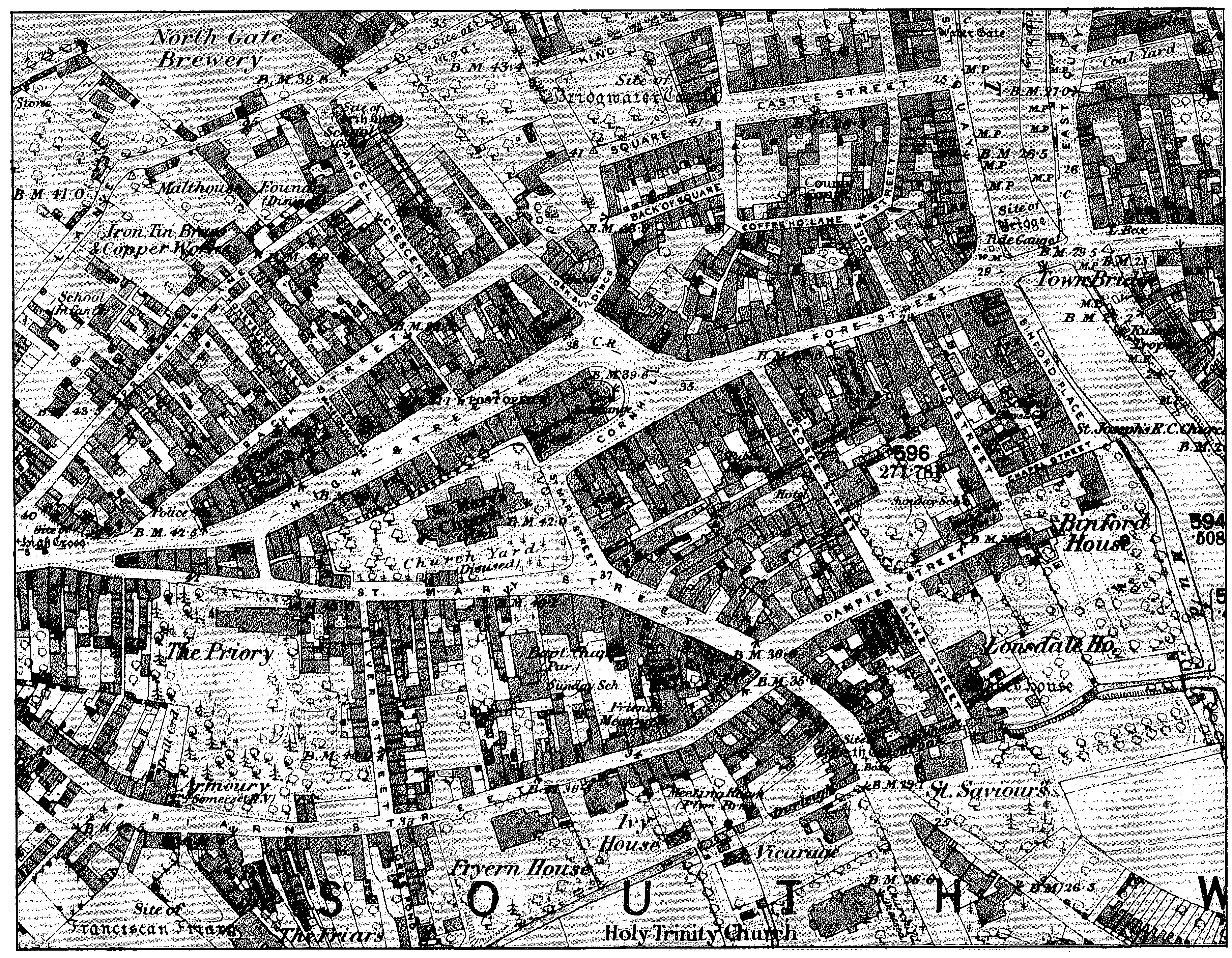
Bridgwater: the town center 1886
South of the church St. Mary Street, so named by 1299, (fn. 91) gave direct access to the cattle market from the south. Further south, Friarn Street, so named in 1298, (fn. 92) marked the line of the town ditch, beyond which was the Franciscan friary. (fn. 93) The gateway to the friary still stood in 1709. (fn. 94) Friarn Street was crossed by a road, by c. 1720 known as Silver Street, (fn. 95) from St. Mary Street to the wayer or horsepool on the Durleigh brook. (fn. 96)
The south-eastern quarter of the town was generally known as Damyet by the mid 14th century, probably in reference to the mill on its southern edge on the Durleigh brook. Damyet, later Dampiet, Street existed by 1344; it may have been the unnamed street mentioned in 1260. (fn. 97) Frog Lane, also named in 1260, probably ran along the river bank; Croniles Lane was said to be in the same area. (fn. 98)
There were three crosses in the town. The high cross, at the junction of the Cornhill and High Street, existed in 1367. It was rebuilt or altered in 1567-8. (fn. 99) By the end of the 18th century the cross comprised six columns supporting a pinnacled roof around a central column which supported a cistern holding the town's water supply. (fn. 100) St. Mary's Cross, at the south-eastern corner of the churchyard, probably marked the original entrance to the market place from the south. (fn. 101) In 1724 the corporation ordered the churchwardens to remove timber and lead from the cross, which probably formed a shelter around the cross shaft. (fn. 102) The cross was removed in 1769 to Penel Orlieu and was demolished in the 1830s. (fn. 103) A replica was built in 1989 at the east end of Fore Street. An 'old' cross stood outside West Gate c. 1480 and in 1543. (fn. 104) This may have been the cross 'on the west of the town' mentioned in 1544 and called St. Anthony's Cross. It was still so named in 1630. (fn. 105) By 1689 its name had been changed to Pig Cross, and it seems by then to have been re-sited in Penel Orlieu. (fn. 106) It was demolished in 1769 and was replaced by St. Mary's Cross. (fn. 107)
In the 1540s there were north, south, east, and west gates, but John Leland saw no other defences. (fn. 108) There had been a defensive wall, at least on the west, where before 1295 a tenant was identified as William the smith in the walls, and in 1302 a site was bounded by the wall on the town ditch. (fn. 109) The 'common ditch of the vill' was still a clear boundary in the mid 14th century, but elm trees were growing on parts of it by the earlier 15th. (fn. 110) The 'old fortifications' were still recognizable in 1653 (fn. 111) and water at high tide filled the ditch 'for a great part about the town'. (fn. 112) Water still ran from beyond the west gate via the Mount along the northern edge of the town to the river in the earlier 18th century (fn. 113) and the Mount itself seems to have been in origin a bastion in the defences, (fn. 114) possibly referred to as near the north gate in 1399. (fn. 115)
The west gate was mentioned in 1299; (fn. 116) it was repaired in 1556, (fn. 117) but has not been traced thereafter. The north gate, also mentioned in 1299, (fn. 118) was rebuilt in 1646-7 but by the 1720s it was in bad repair and was taken down to improve the road in 1798. (fn. 119) Its site was once marked by a stone near the girls' school in Northgate Street. (fn. 120) The south gate, referred to c. 1361, (fn. 121) was removed when the turnpike road was improved in 1822. (fn. 122) The east gate, mentioned in the mid 13th century and later known as St. John's Gate, still stood in 1553. (fn. 123)
The east gate marked the entrance to the town's largest suburb, Eastover, joined by the town bridge to the main part of Bridgwater on the west bank of the Parrett. Eastover was probably established after the bridge was built c. 1200, (fn. 124) and the building of St. John's hospital by 1213 (fn. 125) may mark its eastern extent. A ditch was licensed in 1286 from a point south of the bridge to the hospital, to provide a water-supply, and from there ran beside a causeway northwards to the river. (fn. 126) The single street in Eastover was known variously as 'beyond the bridge', 'between the bridge and the hospital', 'east of the bridge', and 'within the east gate'. (fn. 127) By the mid 14th century it was usually known as Eastover. (fn. 128) Burgages had been established there by the mid 13th century. (fn. 129)
As both the town and Eastover began to outgrow the defences, burgages were laid out beyond the east gate on the road to Horsey by the mid 13th century and beyond the north gate by 1300. (fn. 130) The extent of the town along the Horsey road was marked by 1480 by Kelyng Cross. (fn. 131) Burgages were also laid out beyond the west gate, (fn. 132) along three diverging roads, North Street (named by 1299), (fn. 133) West Street (named by 1377), (fn. 134) and a way to a western horse pool. (fn. 135)
Later growth of the town
The decay of the town c. 1500 (fn. 136) and the reported damage in 1645 (fn. 137) limited the growth of the town until the 18th century, when the gradual destruction of the castle made room for new streets. Castle, originally Chandos, Street was under construction in 1724, and the 'north back street', now Chandos Street, was projected. (fn. 138) Coffee House Lane, named after a coffee house in business in 1730, is mentioned in 1788. (fn. 139) King Square, proposed by the duke of Chandos in 1726, was eventually built between 1807 and 1830. Angel Crescent was built in 1816, (fn. 140) York Buildings by 1823, Russell Place by 1829, and Victoria and Albert streets by 1842. (fn. 141)
In the 1840s the town began to expand eastwards, encouraged by the arrival of the railway, both for residential and commercial purposes. The new parish of St. John the Baptist, Eastover, was created in 1846, (fn. 142) and by 1851 there were terraces along the Bristol and Bath roads and in Monmouth Street. St. John Street, giving access to the railway station, had become a shopping centre by 1861, and terraced streets were built north and south of it: Devonshire Street was begun in the late 1860s, Edward Street completed c. 1880, Rosebery Avenue completed in 1896-7, Cranleigh Gardens in 1905-6. (fn. 143) Similar building west of the town stretched into Wembdon and Durleigh parishes in the late 19th and the earlier 20th centuries.
Further expansion began in the late 1920s on the New Town estate in the north-west, where local authority housing was built for those who had lived in the slums demolished in the town centre. Other areas of public housing in the 1920s and 1930s were along the Bristol and Bath roads to the north-east and Taunton Road and Rhode Lane in the south. (fn. 144) In the 1950s the Sydenham estate east of the railway was built, and the Hamp estate south of the town centre followed from the 1960s. There was further expansion in the south and south-east in the 1980s.
Buildings
A reference of 1397 to a house of three couples in Friarn Street to be built within seven years (fn. 145) and an agreement with a carver in 1515 for a new house in St. Mary Street (fn. 146) suggest that both were timber framed, perhaps with crucks. Timber was probably the normal material for domestic buildings until the later 17th century when bricks became more common. (fn. 147) Among the few timber-framed houses to survive are nos. 2, 39, and 47 St. Mary Street, all of two storeys. No. 2 has a jettied front to the street. A more elaborate house of three storeys with jetties on two sides was demolished c. 1826. (fn. 148) An elaborate carved ceiling of the earlier 16th century now in the Burrell Collection in Glasgow (fn. 149) came from a house in St. Mary Street, demolished in the early 20th century. (fn. 150)
There are no houses with architectural features certainly of the later 17th century, but a number of surviving buildings may belong to that period, and more are recorded in old photographs and drawings. They are generally of two low storeys with a steep pantiled roof aligned with the street. The walls are of brick although it is possible that some have replaced or refaced timber framing, perhaps after the destruction during the Civil War. (fn. 151) The survival, in relatively large numbers, of such houses in the central streets such as Fore Street and High Street suggests that they were the common building type before the 18th century, and there is only one recorded instance of a single-storeyed cottage with attics. (fn. 152) Individual buildings no longer surviving included one with 'a cupillo or tower' of brick, described as newly erected in 1708 and still partly standing in 1802. (fn. 153) There was another building topped by a cupola in St. Mary Street by 1738. (fn. 154)
Castle Street, (fn. 155) laid out c. 1724 by the duke of Chandos, originally provided the site for six houses of five bays on each side of a broad roadway. All are of uniform character, of three storeys, with dressings including string courses and bolection-moulded architraves of ashlar. The main variation is in the design of the doorcases. It is probable that the south side was built some years after the north side, although presumably before 1734 when the duke sold the estate. It is likely that his architect was Benjamin Holloway, whose own house of c. 1730 (fn. 156) was the Lions on West Quay, the most distinguished house in the town. It is of five bays and two storeys with a basement. The full-height centre piece is approached by steps which rise from a courtyard flanked by single-storeyed wings. In a similar style to the Castle Street houses is the Waterloo House public house in St. Mary Street. It is of six bays and has a large 18th-century shop front inserted into much of the ground floor. No. 5 West Quay is probably of similar date and quality but much has been destroyed by an earlier 20th-century shop front. (fn. 157) The Priory in St. Mary Street has also been much altered in the 20th century but it appears to have had a pilastered, early 18th-century front of seven bays flanked by early 19th-century additions.
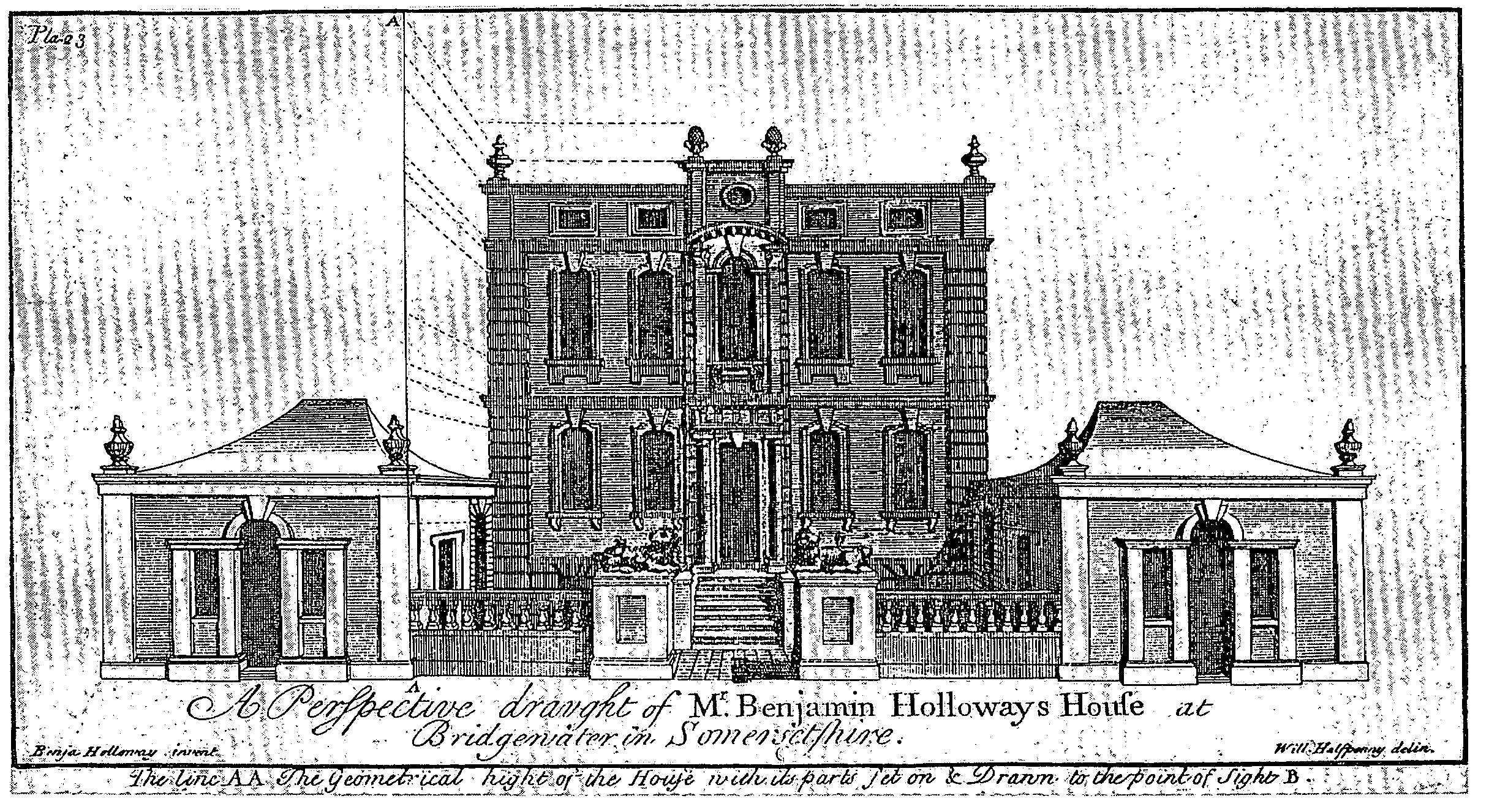
The Lions, West Quay, c. 1730
The most complete surviving house of smaller size is no. 15 Friarn Street, of four bays and three storeys, which does not have stone dressings but has brick plat bands and an elaborate timber shell hood above the doorway. A short terrace of plain, one-bayed, three-storeyed houses in Chandos Street is almost contemporary with the Castle Street houses whose gardens it faces, but in the earlier 18th century most small houses probably continued to be built in the two-storeyed vernacular tradition of the 17th century.
If the Chandos-influenced houses of the earlier 18th century have decorative elements which might in English terms be described as baroque, the buildings of the later 18th and early 19th century are by contrast very restrained. King Square, the one major building enterprise of the period and incomplete, is in the restrained manner, and so is the former Royal Clarence hotel in High Street. The probability is that much of the rebuilding in the town is 19th-rather than 18th-century. Many of the houses are of three storeys and in the 19th century they have stepped voussoirs to the window heads. Contemporary shop fronts were not uncommon. (fn. 158)
As in most other towns the mid 19th century marks the beginning of a period when several styles were used for commercial and domestic building. No. 9 Cornhill has a datestone for 1857 and is Italianate, four storeys high and six bays long. The Infirmary was refronted in 1876 in a mid 18th-century style and the former Y.M.C.A. building at the corner of Eastover and Salmon Parade had ornamental brickwork and a roofline inspired by northern European gothic. (fn. 159) Most idiosyncratic is Castle House, Queen Street, late gothic in outline and decoration with early Renaissance rustication, built in 1851 to demonstrate the versatility of Portland cement. (fn. 160)
As early as the 18th century there had been a few houses standing in spacious grounds (e.g. the Priory and Hamp House) and they became more numerous as the town spread outwards in the mid 19th century. (fn. 161) Most of the growth of the built up area, however, was in the form of streets of relatively uniform terraces (fn. 162) or semidetached pairs. (fn. 163) Ornamental bricks and tiles, manufactured in the town, (fn. 164) were used to decorate even the humbler houses. On some of the less humble houses unfaced stone is used for walling, and gables with ornamental bargeboards are common, perhaps in an attempt to be different.
The part of the town east of the river appears always to have had an architectural character inferior to that of the west. The only early buildings of quality are on the river frontage. No. 4 East Quay appears to be a design derived from the mid 18th century London pattern books, especially in its eared architraves, quasipilasters, and 'Gibbs' door surround, but the interior appears to be of the early 19th century. In Eastover several two-storeyed houses with steep pantiled roofs are probably late 18th-century in origin, and in Monmouth Street the demolished Rookery was probably late 18thcentury and the earliest suburban terrace in Bridgwater. (fn. 165) Monmouth Terrace and adjacent houses are mostly of two or three bays with semicircular heads to the windows. Church Street and Blake Place were presumably nearly contemporary with St. John's church, erected in 1843. (fn. 166) Most of the houses are in dark brown coursed rubble with lighter stone or painted wood architraves; those nearest the church are semidetached, the remainder terraced. Nearer the railway, houses of the mid 19th century are nearly uniform two-storeyed terraces of red brick without front gardens and the only decorations are the ornamental door and window heads.
A hall of pleas in Fore Street belonged to the castle estate and was mentioned in 1347-8. (fn. 167) It may have been the building known in 1431-2 as the shire hall. (fn. 168)
A guildhall recorded in Fore Street in 1354 evidently had a first-floor room above booths. (fn. 169) Known variously in the 15th and 16th centuries as the common house, the town house, or the town hall, (fn. 170) it was called the guildhall in the 18th century, when separate rooms within the building included a burgess hall or council house, a serjeants' hall, and the 'mayor's alphabet', a small room for the corporation's library and records. (fn. 171) A room over the burgess hall was divided in 1743. (fn. 172) The building, which had an entrance with steps and columns, was in a poor state of repair by 1808, and its demolition was suggested. (fn. 173) The corporation moved to the grand jury room at the assize hall in High Street in 1822, and the guildhall was probably demolished soon afterwards. In 1823 they moved to a new building adjoining. That building, designed by Richard Carver and financed by an 'improvement committee' including Sir Thomas Lethbridge and other members of the grand jury, provided a town hall and strong room for the corporation, lodgings for the judges, and witness and jury rooms. (fn. 174) It is of limestone in a simple classical style with panelled pilasters. The corporation later extended its use of the building when the assizes ceased to be held in the town; in the 1880s part was used as a police court and part as a free library. (fn. 175) It is now used as offices by Sedgemoor district council and by the Bridgwater charter trustees. A new town hall was built behind, on the site of the former assize hall, in 1865 to the designs of Charles Knowles. (fn. 176) It is of rusticated stone and brick in a Venetian style.
Until 1720 a temporary 'boarder house' was erected for the assizes near the high cross, and in order to ensure that the judges came regularly to the town the corporation then agreed to buy out the right of the tenant of the Red Cow inn on the north side of High Street and to build there a permanent assize hall. (fn. 177) The building, 'most magnificent, large, and capacious', was said to have been erected in six weeks 'after the model of Westminster Hall'. (fn. 178) The cost was borne by local gentry and by members of the corporation, and the work was supervised, and possibly designed, by John Gosling. (fn. 179) The hall, to which a grand jury chamber was added c. 1722, was also used for quarter sessions. (fn. 180) When not in use by judges or magistrates the building was a store for wool, flax, hides, and tallow. (fn. 181) The front of the building was colonnaded, providing space for market stalls. The court room, which was galleried, was divided in 1776, and seats for a jury were added in the part used for assizes. (fn. 182) The building was demolished in 1856. (fn. 183)
There was a prison in Bridgwater c. 1210, (fn. 184) probably in the castle. A prison was claimed by both the Crown and Roger Mortimer in 1280. (fn. 185) The gaol was mentioned in 1352, (fn. 186) 1481, (fn. 187) the mid 17th century, and 1728. (fn. 188) Its condition was severely criticized by John Howard in 1789. (fn. 189) The building, on the south side of Fore Street, had an imposing rusticated classical frontage; it was closed and demolished in 1875. Cells were built at the police station in High Street, and in 1911 at the new station in Northgate. (fn. 190) A lock-up called the Cockmoyle prison was mentioned in 1575. (fn. 191) It was later said to be part of an inn of the same name, and in 1687-8 was called the borough bridewell. (fn. 192) The lock-up was evidently on an upper floor over a lane between High Street and the churchyard, since it was known as the higher prison in the 17th century and Upper Bow in the 18th. (fn. 193) In 1729 the quarter sessions established a bridewell for the borough and parish, probably an extension to the town's prison, and set up a whipping post there. (fn. 194)
An old pillory was mentioned in 1378. (fn. 195) In the early 17th century the pillory stood in High Street by the stocks and near the site of the present town hall. (fn. 196) In 1744 the corporation ordered the pillory to be removed to the Cornhill, but both pillory and stocks were in 1782 to be set up again on the old site. (fn. 197) No further record of either has been found.
St. John's hospital had been established by 1213 (fn. 198) at the eastern end of Eastover. New buildings seem to have been erected c. 1350, (fn. 199) and in the mid 15th century the site included a church, chapter house, and cloister, with rooms including a parlour off the cloister, the whole surrounded by gardens. (fn. 200) The church was c. 112 ft. long. (fn. 201) Leland described the hospital as partly outside the east gate. (fn. 202) At the Dissolution the site passed into private hands, (fn. 203) but parts of the hospital still stood in 1703. (fn. 204)
The convent of Friars Minor (Franciscans or Grey Friars) was founded in 1245-6. (fn. 205) The friars left the original site, by 1358 occupied by nine burgages, (fn. 206) for one south-west of the town, between the town ditch and the Durleigh brook. (fn. 207) Timber was given for unspecified buildings in the 1250s, for a dormitory in 1278, and for further work in 1284, (fn. 208) and land was added to the precinct in 1349. (fn. 209) The conventual church was rebuilt in the earlier 15th century, and it and its burial ground were consecrated in 1445. (fn. 210) In 1538 the buildings comprised a church and simple domestic quarters, the church measuring 210 ft. by 52 ft. (fn. 211) Some of the buildings and the lead were sold, but the domestic quarters were in the 1540s a fine dwelling house. (fn. 212) The house was owned by the Saunders family in 1571 and 1629, (fn. 213) but only the 'cemetery and churchyard' survived in 1720. (fn. 214)
Inns and taverns
A tavern on the west side of the high cross in 1367 and Robert Plympton's inn in High Street in 1376 were the earliest recorded inns in the town, (fn. 215) and the George in St. Mary Street was mentioned between 1392 and 1421. (fn. 216) In the 16th century the inns included the Bell, belonging to Holy Trinity chantry, the Saracen's Head, belonging to Athelney abbey, and the Ship, belonging to St. John's hospital; the Swan, leased late in the century to the corporation by the Crown for a rent of 4d., the price of 4 iron horseshoes, and 38 iron keys; the Angel, the White Hart, and in Eastover the Three Crowns. (fn. 217)
In the 17th century the justices used to meet at the Angel in High Street, and other prominent houses were the Crown, the Lamb, the Noah's Ark, the Red Cow, and the Red Lion. (fn. 218) In 1686 the town's inns offered 143 beds and stabling for 246 horses. (fn. 219) Other inns included the Blue Anchor, the Black Boy, the Rose, the Three Cups, the Three Mariners, and the Valiant Soldier. (fn. 220)
The Red Lion and the Fighting Cocks seem to have been frequented by the rival political factions on the corporation in the early 18th century, and the Swan was the regular haunt of troops billeted in the town. (fn. 221) In the 1720s there were said to be over 120 houses selling ale and cider in the town, (fn. 222) and by 1748 the town was divided into three divisions for licensing purposes when there were just over 50 licensed houses and a single coffee house. (fn. 223) The Swan, the Castle Tavern, the King's Head, and the Fountain were regularly used for excise hearings in the 18th century. (fn. 224) There were still at least 50 licensed houses in the 1790s, and 45 in 1822-3. Seven stood on the Quay, including the Ship on Launch; 8 were in Eastover, and the remainder mostly in the town centre including 10 in and around High Street. Among those was the Valiant Soldier, which in 1790 had a fives court. The principal establishments were the George, the Swan, and the King's Head. (fn. 225) In 1825, as part of the rebuilding of the north side of High Street, the Royal (later Royal Clarence) hotel replaced the former Crown and Angel inns, and until it closed in 1984 was the principal establishment in the town. (fn. 226) Inns opened away from the town centre mark the spread of the built-up area; the Railway hotel, by the railway station, in 1839-40; the Mermaid in Bath Road in 1859, the Crowpill in Chilton Street by 1869, and eleven inns in St. John Street in the 1870s. (fn. 227) There were 71 hotels, inns, and beerhouses in the parish in 1909, 44 in 1988. (fn. 228)
Social and cultural activities
A play was performed in the shire hall in 1431-2, (fn. 229) and pipers from Ash Priors took part in the Corpus Christi pageant in 1449. The pageant, also called the shepherds' pageant, was last recorded in 1543. (fn. 230) The king's players visited the town in 1461-2. In 1494-5 minstrels of the king, the king's mother, the earl of Arundel, and the mayor of Bristol were rewarded for their visits. (fn. 231) Among the entertainers who visited frequently until the 1560s were the players of the duke of Somerset and of the earls of Bridgwater and Bath, whose patrons had landed interests in and around the town; the players or minstrels of the sovereign, the Lord Admiral, the marquess of Dorset, the earl of Worcester, Lord de la Warr, Lord Mountjoy, and Mr. Fortescue. A Christmas play at the mayor's house and exhibitions of lions and bears were among the other entertainments. (fn. 232) Players were not regularly recorded in the later 16th century, although one killed in the town was buried there in 1597, and Lord Berkeley's players were paid in 1603-4. (fn. 233) Some 'stage players' performed at the town hall in 1722, and a company of comedians from Bath hired the assize hall for several weeks in 1736. (fn. 234) Travelling players seem to have visited the town during the summer assizes c. 1800, and by 1813 a theatre had been established in Penel Orlieu under Henry Lee. (fn. 235) Edmund Kean performed in the town in 1816. (fn. 236) The theatre, described as in Back Street in 1834, was then lit with gas; the magistrates withdrew its licence in 1853. (fn. 237) The Bijou theatre was opened in St. Mary Street in 1912, the Palace in Penel Orlieu in 1916, both as cinemas, and by 1925 the town hall was used as a theatre. In the same year the former Bijou was reopened as the Empire, the Arcade cinema was opened in Eastover in 1929, and the Odeon in Penel Orlieu in 1936. The former Palace was reopened in 1940 as a social centre for troops. An arts centre in Castle Street, claimed to be the first of its kind in Britain, was established in 1946. (fn. 238)
Dancing at the guildhall, forbidden by the corporation after a few years in 1731, was revived in 1755 in connexion with horse races. The races, held originally in the summer and continuing in the 1780s, were later abandoned but were revived in 1813 when the Taunton races were transferred to Bridgwater. By the 1820s they took place early in September at Crook, northeast of the town, on a mile-long circular course. In 1854, after a gap, they were revived in late August and by 1867, as the Bridgwater and West Somerset races, were held at the end of September. The Bridgwater steeplechase and hurdle races were held in 1898 but were said to have been abandoned by 1905. Races were revived in July 1926 at Durleigh, but were discontinued in 1929. (fn. 239)
Tennis and fives were played in the town in the 17th century, and the corporation owned a bowling green in Eastover until the 1720s. (fn. 240) Popular entertainment is suggested in the field name Bull Baiting acre, adjoining Castle field. (fn. 241) Revels were said to have been held near Pig Cross on Oak Apple Day (29 May) until the 1830s. (fn. 242) Annual amusements, including public breakfasts, balls, and backsword play, were held on Chilton common by 1793, and a festival, probably to celebrate peace with France, was planned to entertain 10,000 people on the Cornhill in 1814. (fn. 243) Bonfires traditionally held on the Cornhill to commemorate the Gunpowder plot took on political overtones in the 1850s, and the crushing of the Indian Mutiny inspired a procession, the first to be called a carnival, in 1857 with decorative floats, a band, and firework displays known as 'squibbing'. (fn. 244) Processions in 1882 and 1883, the second to celebrate the completion of the new town bridge, were followed by a more organized carnival in 1884, beginning a tradition for which Bridgwater has become renowned. (fn. 245) The last bonfire on the Cornhill was made in 1924, but the squibbing (fn. 246) and the carnival floats, each built by competing carnival clubs from within the town and from throughout the county, have made Bridgwater carnival the most popular tourist attraction of its kind in the West of England.
Bridgwater cricket club was founded in 1832. (fn. 247) Turkish baths were opened in York Buildings in 1861, and swimming baths in Old Taunton Road in 1890. (fn. 248) The baths were replaced by the Lido in Broadway in 1960, and the Lido by the Sedgemoor Splash in Mount Street in 1991. (fn. 249) The Blake Gardens were opened in 1902, Eastover recreation ground in 1905, and Victoria Park c. 1928. (fn. 250)
There was a reading room in the market house by 1830 which by 1840 had become the Literary and Scientific Institution. (fn. 251) By 1861 there were reading rooms in St. John's Street, Taunton Road, and West Street, the first still in use in 1889. (fn. 252) By 1859 the Literary and Scientific Institution had been moved to George Street where there was a museum 1861-75 and a reading room in 1875. (fn. 253) A reading room at the town hall by 1889 remained there until 1906 when the present library was opened in Binford Place. (fn. 254) The present museum, known as the Admiral Blake Museum, was opened in Blake Street in 1926. (fn. 255)
The first newspaper in the town was the Bridgwater and Somersetshire Herald, founded in 1825, which continued 1831-3 as the Alfred. The Bridgwater Times was published 1846- 61 and was followed by the Bridgwater Standard (1861-70) and the Bridgwater Gazette (1871-85) which, as the Bridgwater Independent, was continued 1885-1933. The Bridgwater Mercury and Western Counties Herald, begun in 1857, (fn. 256) continued in 1991.
Before c. 1820 there were seven friendly societies in Bridgwater, each based at an inn, the earliest at the Three Tuns, apparently founded in 1795. One for mariners was founded in 1805, another for carpenters and joiners in 1811, and a third based at the Baptist church in St. Mary Street in 1818. In the mid 19th century national societies for tradesmen were active. (fn. 257)
National events
King John visited Bridgwater in 1204, 1205, 1208, and 1210, and Henry III in 1250. (fn. 258) Prests were delivered in the town to William Longespee, earl of Salisbury, in 1208-9 (fn. 259) and a tax levied in Cornwall in 1234 was to be taken for safe custody to the town. (fn. 260) Letters patent were dated there in 1221. (fn. 261) Royal justices met in the town in 1204, in the 1250s, in the 1270s, and in the later 14th and earlier 15th century. (fn. 262) The assize judges sat in Bridgwater each summer from 1720 but by 1797 and until 1853 every other year. (fn. 263) The Michaelmas quarter sessions for the county met in Bridgwater by the later 16th century and until 1670, when instead the town held the Midsummer sessions. (fn. 264) The sessions continued to be held there until 1853. (fn. 265)
In 1381 Bridgwater was the scene of a serious disturbance when St. John's hospital was attacked and the master forced to surrender bonds held against townsmen. (fn. 266) In 1469 Humphrey Stafford, earl of Devon, was executed in the town. (fn. 267) In 1528 sessions of the peace in both Bridgwater and Taunton were interrupted by insurrection, (fn. 268) and in 1536 four men were executed in the town after a rising at Taunton. In 1539 part of the body of Richard Whiting, abbot of Glastonbury, was displayed at Bridgwater. (fn. 269) The town was chosen as the title for a possible suffragan bishopric in 1534, but no appointment was ever made. (fn. 270)
In June 1643 half the parliamentary garrison of Taunton, retreating before the king's army, stayed briefly in the town. Supporters of parliament were said to be 'very strong' there, but others attempted to detain the troops. (fn. 271) Some 2,000 men were said to have left at night as the marquess of Hertford advanced. (fn. 272) The royalist garrison then installed was commanded by Col. Edmund Wyndham of Kentsford, recently M.P. for the borough, and the defences of the town included four guns ordered by Prince Maurice. (fn. 273) Some of the garrison mutinied when there were rumours of Irish troops landing at Minehead and Bristol. (fn. 274) In 1643, between June and November, 17 soldiers were buried in the town. (fn. 275)
In 1644 the governor refused to use his troops to protect excise collectors from attacks, in which some local recruits joined. (fn. 276) In August men from the garrison beat off 500 parliamentary horse who had attacked a supply column near North Petherton. (fn. 277) During the year 20 soldiers were buried in the town including two killed at North Petherton. (fn. 278)
In the year from September 1644 the town paid for 400 pairs of hose and shoes for the king's forces then at Wells. (fn. 279) Prince Rupert and the leaders of the Western Association met in Bridgwater in April 1645. (fn. 280) After his defeat at Langport on 10 July Goring brought his guns and some infantry into the town. (fn. 281) The New Model army followed up its success by a gradual investment from the south and east. Maj.-Gen. Massey established his headquarters at Hamp House, and Col. Holborne took Sydenham Manor. The defenders, behind earthworks at the east end of St. John's field and between there and Dunwear, were equipped with 40 guns, and mounted a battery between the west and north gates, at what was later called the Mount. (fn. 282) Sir Thomas Fairfax, in command of the parliamentary forces, placed troops in the fields of Horsey and Bower, and five regiments of the New Model under Cromwell were drawn up in St. John's and Castle fields. (fn. 283)
The town was stormed on 21 July 1645. Fairfax took Eastover with 600 prisoners, finding that most of the suburb had been fired. He then crossed the Parrett, forcing the royalists to yield the town. A total of 2,000 prisoners, 800 horse, and 36 guns were taken. (fn. 284) Estimates of the damage varied. Fairfax said that a third of the town had been burnt, while a royalist declared that 'most of the town' was destroyed by fire except some houses near the castle, the damage ascribed either to Col. Wyndham or to the townsmen. (fn. 285) Henry Harvey, lord of the Castle manor, claimed to have lost £4,000 including a house by the bridge, and the mayor in 1656 asked help to repair 120 houses destroyed in the town including the almshouses. (fn. 286) Many of the inhabitants had removed themselves for safety to Wembdon. (fn. 287) Between 8 January and 17 July 1645, before the siege, 68 soldiers were buried in the town; thereafter no burials were registered until 1 December. (fn. 288)
Troops remained in the town, which was used as a base for the expedition to Ireland, (fn. 289) and in 1646 blood was shed when the County Committee used them against a crowd of local people who had come to help slight the defences. (fn. 290)
In 1646-7 the corporation paid for the removal of guns from the quay and the wages of three men for three days 'towards dismantling of the garrison'. In 1647-8 it celebrated with wine when the dragoons left the town, and in 1648-9 made a gift to the 'Lord General's clerk' for 'taking of the soldiers from the town'. (fn. 291) A company was to be raised there in 1659 and Col. Richard Bovet's regiment was then in the town. Part of it was sent towards Bristol in 1660 for Gen. Monk. (fn. 292)
During Monmouth's rebellion the town was occupied twice by rebel troops and for at least a year afterwards by regular dragoons. The corporation formally proclaimed Monmouth king on 21 June 1685 and the town was more generous than any other in voluntary contributions to his cause. Monmouth himself had quarters in the castle, his army on Castle field. (fn. 293) Remarkably few townsmen were reported absent from home during the time of the rebellion or were otherwise accused of complicity. (fn. 294)
The rebels returned to the town for two days before the battle of Sedgemoor, barricading the bridge and setting up guns at the high cross, in the castle, and at the south gate. (fn. 295) After the battle the king's troops chased some of the rebels into the town and then brought their wounded for treatment. The corporation was not paid for their maintenance until 1687. (fn. 296) Nine rebels were hanged, drawn, and quartered in the town. (fn. 297) James II visited the town briefly in 1686, (fn. 298) and the corporation soon afterwards petitioned that dragoons still quartered in the town should be removed. (fn. 299)
In the early 18th century political rivalry, accusations of Jacobitism, and the presence of troops caused several riots in the town. (fn. 300) John Oldmixon (1673-1742), the Whig pamphleteer, was customs collector there 1716-30, and acted for James Brydges, duke of Chandos, who had commercial interests in the town. (fn. 301)
Robert Blake (1598-1657), admiral and general, was born in the town; John Allen (1660-1741), physician and inventor, practised and died there; and Henry Phillpotts (1778- 1869), bishop of Exeter, (fn. 302) and Francis Joseph Grimshaw (1901-65), Roman Catholic archbishop of Birmingham, were born there. (fn. 303)