A History of the County of Somerset: Volume 7, Bruton, Horethorne and Norton Ferris Hundreds. Originally published by Victoria County History, London, 1999.
This free content was digitised by double rekeying. All rights reserved.
A P Baggs, M C Siraut, 'Charlton Horethorne', in A History of the County of Somerset: Volume 7, Bruton, Horethorne and Norton Ferris Hundreds, ed. C R J Currie, R W Dunning (London, 1999), British History Online https://www.british-history.ac.uk/vch/som/vol7/pp84-93 [accessed 30 April 2025].
A P Baggs, M C Siraut, 'Charlton Horethorne', in A History of the County of Somerset: Volume 7, Bruton, Horethorne and Norton Ferris Hundreds. Edited by C R J Currie, R W Dunning (London, 1999), British History Online, accessed April 30, 2025, https://www.british-history.ac.uk/vch/som/vol7/pp84-93.
A P Baggs, M C Siraut. "Charlton Horethorne". A History of the County of Somerset: Volume 7, Bruton, Horethorne and Norton Ferris Hundreds. Ed. C R J Currie, R W Dunning (London, 1999), British History Online. Web. 30 April 2025. https://www.british-history.ac.uk/vch/som/vol7/pp84-93.
In this section
CHARLTON HORETHORNE
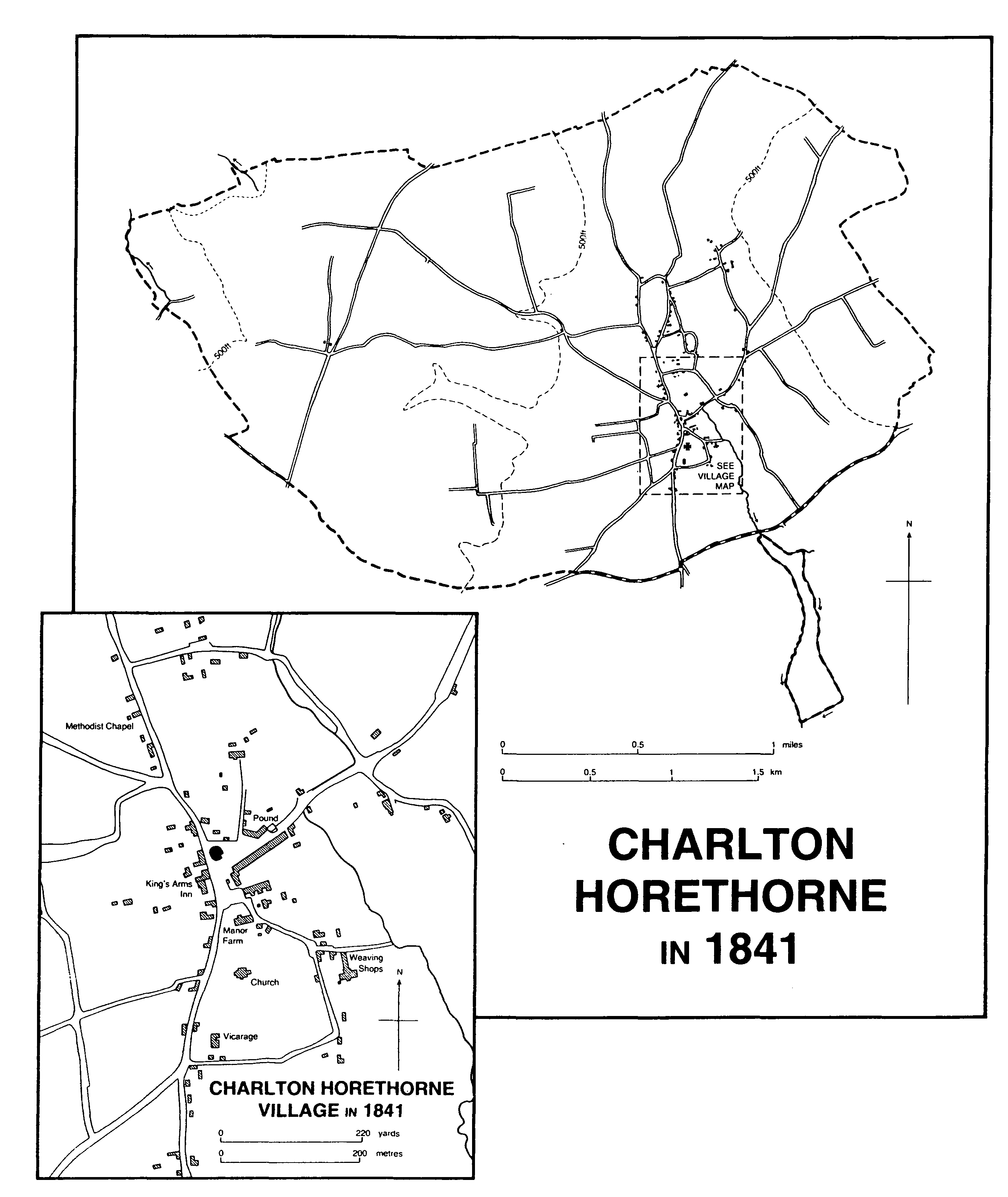
Charlton Horethorne in 1841
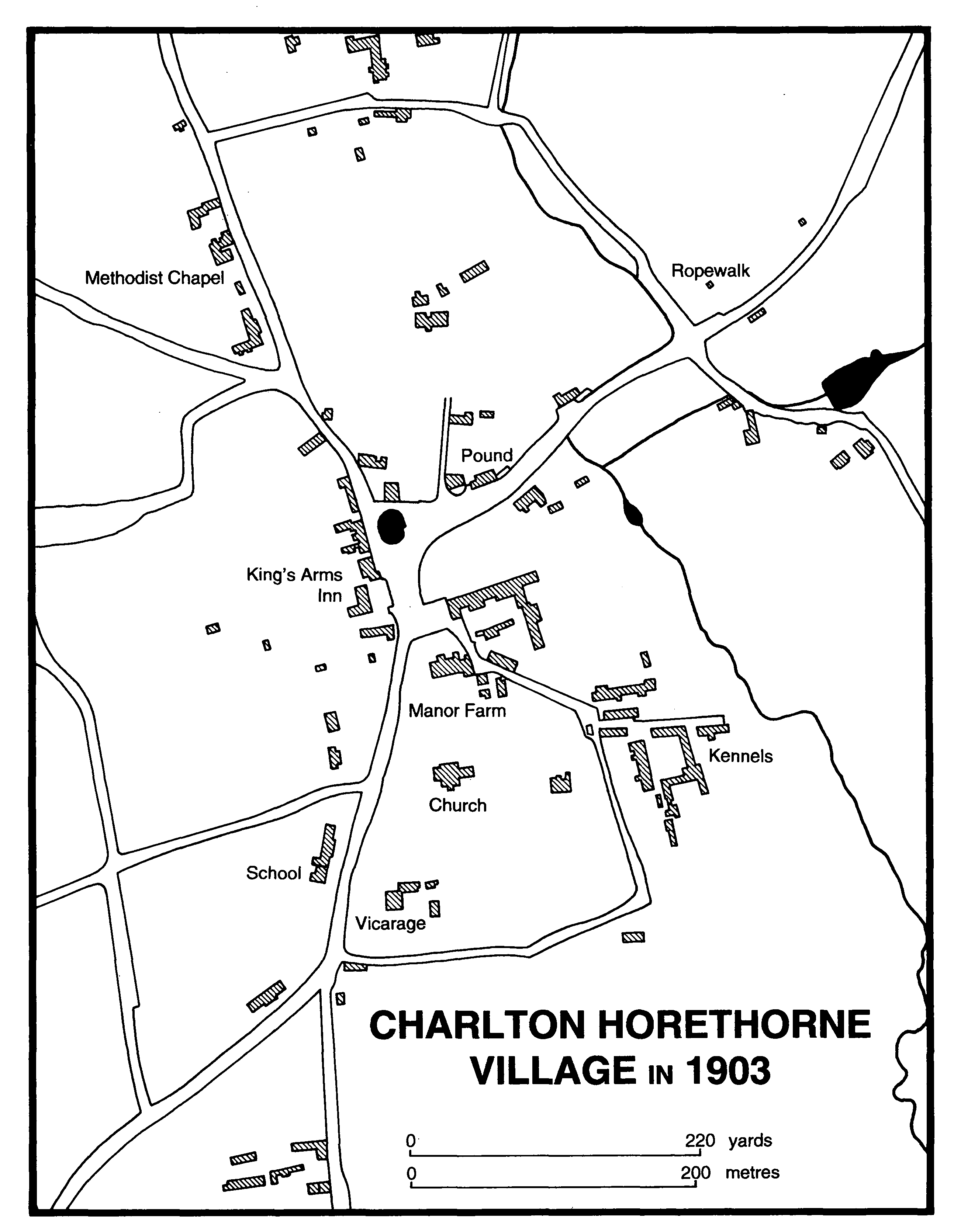
Charlton Horethorne Village in 1903
The ancient parish of Charlton Horethorne or Charlton Camville (fn. 1) lies 5 km. north of Milborne Port, of which it may have been a dependency. (fn. 2) It was roughly ovoid in shape with a small extension south to include an island of meadow between two branches of the stream running down to Milborne Port. It measured 2.5 km. from north to south and 4.5 km. from east to west at its widest point. Lanes and footpaths mark the boundaries.
Charlton village lies near the end of a valley reaching into the parish from the south. To the east of the valley the land rises steeply to Windmill (185 m. (608 ft.)) and Charlton (182 m. (597 ft.)) hills and thereafter falls gradually to the eastern boundary with North Cheriton and Horsington. To the west the gradient is more gentle, forming the dip slope of an escarpment which reaches to 194 m. (636 ft.) beyond Sigwells before falling steeply towards Corton Denham. The valley itself is above the 100-m. (325-ft.) contour. (fn. 3) The ancient parish measured 2,362 a. (fn. 4) The present civil parish covers 1,340 ha. (3,311 a.), having lost the small southern extension to Stowell in 1885 (fn. 5) but having absorbed Stowell in 1933. (fn. 6)
Most of the parish lies on Inferior Oolite with small intrusions of Yeovil Sands; on the east of Charlton village are bands of Fullers Earth and Fullers Earth Rock with alluvium and, in the extreme east, Forest Marble clay. (fn. 7)
Roads from neighbouring parishes all focus on Charlton village, where a central triangular area includes a green and, formerly, a large pond. (fn. 8) The early pattern of lanes was overlaid by two turnpike roads. The Sherborne-Wincanton road through the village, turnpiked by the Wincanton trust between Wincanton and Milborne Port in 1756 and diverted south of the village in 1798 away from Milborne Port towards Seven Wells in Corton Denham, may have used earlier lanes along part of its route. (fn. 9) The Sherborne-Bruton road was built across the west of the parish by the Shaftesbury and Sherborne trust in 1753. (fn. 10)
Three Bronze-Age barrows and a possible Iron-Age camp lie near Sigwells on the escarpment in the west of the parish, (fn. 11) an area where Mesolithic and Romano-British material has also been found. Other Romano-British artefacts include an altar discovered in the churchyard. (fn. 12) Sigwells, on the later Sherborne-Bruton road, was referred to in 1327 (fn. 13) and beyond it was part of the shrunken village of Whitcomb, now wholly in Corton Denham. The Gilberts' house there, described in 1540 as a 'poor mansion place', (fn. 14) may have been demolished after 1612 when a dovecot was recorded. (fn. 15) Encaustic tiles were found on the site and 15th- to 17th-century potsherds. (fn. 16) Down Farm in the south-west of the parish was created in the mid 19th century after inclosure. (fn. 17)
The village has spread northwards to the head of the valley at Silver Knap and in the 20th century houses have been built there and immediately west of the village. Many of the farms and cottages were rebuilt in the 19th century, mostly in the 1850s, (fn. 18) but a few 17thand 18th-century buildings survive including Manor Farm House and Monks Place, (fn. 19) Charlton Horethorne House, and Bull Inn, formerly Bullens, farm. (fn. 20)
In 1942 an airfield was made on 355 a. at Sigwells farm in the west of the parish. Named H.M.S. Heron II, it was used as a satellite to the naval air station at Yeovilton until 1947. (fn. 21)
Henry de Lacy, earl of Lincoln, received a grant of free warren in 1294 (fn. 22) and a warren on the western edge of the parish formed part of the Whitcomb estate in Corton Denham. (fn. 23) A line of small woods in the north-east of the parish may be fragments of a larger area of woodland stretching into North and South Cheriton. (fn. 24)
In 1617 there was an inn called the Roebuck and two alehouses, (fn. 25) and in 1620 a victualling house was licensed. (fn. 26) There were two licensed premises for most of the 18th and the 19th centuries: the Smiths Arms recorded between 1781 and 1828 (fn. 27) and the Red Lion between 1792 and 1891. (fn. 28) The Red Lion, originally opposite the churchyard, was destroyed by fire in 1854 and the name and licence were transferred to the Hussey family's former capital messuage north of the village. (fn. 29) The Black Lion was probably licensed in 1765 and closed by 1767. (fn. 30) The King's Arms, west of the village green, was recorded in 1812, licensed in 1813, (fn. 31) and remained open in 1993. It was rebuilt in the 19th century. (fn. 32)
There was a maypole in the village in 1615. (fn. 33) In the early 19th century a mumming play was enacted at Christmas and a village feast was held on Charn Hill with gingerbread stalls and cudgel matches. The feast, later linked with the club day of the Charlton Horethorne friendly society, meeting 1842-52, (fn. 34) included cycle races in the late 19th century and is still held. (fn. 35) In the early 1840s a steeplechase was held at which two people were killed. (fn. 36) In 1900 there was a November carnival in the parish. (fn. 37) The Blackmore and Sparkford Vale Hunt, formed 1971, and the Huckworthy Basset Hounds, formed 1963, had kennels in the village. (fn. 38)
In 1641 there were 215 taxpayers in the parish. (fn. 39) In 1801 the population numbered 512 and fluctuated, with a peak of 569 in 1841, until 1871 after which it fell steadily to 478 in 1881, to 434 in 1901, and to 375 in 1921. It recovered gradually to 390 in 1931 and to 492 in 1951 after absorbing Stowell. The resident population in 1981 was 551 and in 1991 was 547. (fn. 40)
The Wiltshire antiquary Thomas Baker was born in the parish in 1833 and wrote an account of the village. (fn. 41)
MANOR AND OTHER ESTATES
Charlton, later Charlton Camville or Charlton Horethorne, appears to have belonged to Wynflaed (d. c. 950), and may have passed to her daughter Aethelflaed. (fn. 42) It was held by Vitel in 1066 and by Robert son of Gerold (d. 1102) in 1086. (fn. 43) Robert may have been followed in succession by his nephew William de Roumare (d. c. 1161) and by William's grandson William (d. c. 1198 s.p.). (fn. 44) The manor was said to have been acquired before 1217 by Hubert de Burgh, earl of Kent, (fn. 45) and overlordship descended like Charlton Musgrove with the earldom of Kent in the honor of Camel until 1411 or later. (fn. 46) In 1427 it was said to have been held in chief. (fn. 47)
By the mid 12th century the terre tenancy was held by the Camville family. Gerard de Camville (fl. 1140) (fn. 48) was followed by Richard (d. 1176). (fn. 49) Richard was succeeded by his son Gerard (d. 1214), (fn. 50) after whose death CHARLTON appears to have been seized by Hubert de Burgh. In 1217 it was restored to Gerard's widow Nichole de la Hay (d. 1230) and to her son Richard de Camville (d. 1226). Nichole was followed by Richard's daughter Idony (d. c. 1252) (fn. 51) and by Idony's son William Longespée (d. 1257). William's daughter Margaret married Henry de Lacy, earl of Lincoln (d. 1311), (fn. 52) and their daughter Alice married Thomas Plantagenet, earl of Lancaster (d. 1322). (fn. 53)
In 1319 John de Warenne, earl of Surrey (d. 1347), acquired the manor for his life (fn. 54) and in 1327 his wife Joan de Bar in turn received a life interest. (fn. 55) Joan let it for her life to Edward, prince of Wales, probably between 1350 and 1352, (fn. 56) and on her death in 1361 it passed to William de Montagu, earl of Salisbury. (fn. 57)
On the death of William in 1397 it was granted to his widow Elizabeth (d. 1415) in dower (fn. 58) and thereafter descended to Thomas, William's great nephew. He died in 1428 and the manor passed to his male heir, his uncle Sir Richard de Montagu (d. 1429), although Thomas's widow Alice (d. 1475) apparently held a third in dower. (fn. 59) It reverted to the Crown and was farmed until 1433 when it was granted to John, duke of Bedford (d. 1435). (fn. 60) In 1439 it was bought by Henry Beaufort, bishop of Winchester, who gave the manor to St. Cross hospital, Winchester, in 1445. (fn. 61)
In 1455 the hospital granted the manor to William Waynflete, bishop of Winchester, (fn. 62) but in 1461 it reverted to Alice, countess of Salisbury, the manor being subject to the dower claim of Jacquetta, duchess of Bedford (d. 1472). (fn. 63) Alice died in 1462 and the manor descended to her granddaughter Isabel (d. 1476), wife of George Plantagenet, duke of Clarence (d. 1478). Although Isabel left a son, Edward Plantagenet, (fn. 64) Margaret Beaufort, countess of Richmond (d. 1509), successfully claimed the manor in 1492 as heir to the Beauforts, (fn. 65) and it descended to her grandson King Henry VIII. Edward Plantagenet's sister Margaret, widow of Sir William Pole, successfully petitioned for the restoration of her estates in 1513-14 and became countess of Salisbury, (fn. 66) but by 1517 the manor had been resumed by the Crown and was farmed (fn. 67) until Edward VI granted it to William Herbert, earl of Pembroke. Pembroke sold it to George Gilbert in 1566. (fn. 68) Until 1573 or later the Crown retained the right to appoint the reeve. (fn. 69)
George Gilbert (d. 1593) left a son and heir Maurice, but by 1612 the manor was held by his second son James (fn. 70) who in 1616 sold it to William Turner. (fn. 71) William sold it in 1635 to John Williams (d. 1636) who was succeeded by his son William. (fn. 72) William Williams was followed by John Williams (d. c. 1690) who left it in trust for sale. (fn. 73) Before 1710 it was acquired by John Wright (fn. 74) who died in 1725. His brother Sir Nathan Wright, Bt. (d. 1737) left two daughters, Anne and Dorothy. (fn. 75) In 1746 the manor was bought by Peter Walter (d. 1753) and it descended like Milborne Port (fn. 76) to Henry William Paget, marquess of Anglesey. (fn. 77) In 1848 the manor was bought by the trustees of Sir Edward Stanley (d. 1843), whose son Edmund conveyed it before 1853 to his brother James. In 1859 it was sold to the trustees of Edward Digby, Earl Digby (d. 1856). (fn. 78) It remained part of the Sherborne Castle estate until the early 20th century. The farms and land were sold in 1914, 1926-7, and 1929 and lordship was sold with Manor farm to the tenants, the Parsons family, in 1927. (fn. 79)
Great and small chambers and a great garden at the manor house were let in 1485 and 1510. (fn. 80) In 1633 the capital messuage was said to have been rebuilt by William Turner, lord from 1616, and it was described as a handsome residence built from freestone dug out to make the cellars. (fn. 81) Manor Farm House, north of the churchyard, is of local ashlar with a stone and clay tile roof, formerly gabled, (fn. 82) and has a 5bayed front with a central 2-storeyed porch, cellars, attics, and a semi-circular stair turret at the east end. It has mullioned windows and two 17th-century staircases, but the interior has undergone considerable alteration.
John de Plecy (d. 1313) held land of the manor for a pair of gilt spurs. He was followed in succession by his son Edmund, Sir Nicholas de Plecy (d. 1357), and Nicholas's son John. (fn. 83) John and his brother Nicholas both died under age in or before 1362 leaving as heir their sister Joan, wife of John Hamely. (fn. 84) The rent from the estate passed to Michaela (d. 1425), John Plecy's widow, who later married successively Richard Darby and Robert Coker. It was not recorded after 1425. (fn. 85)
An estate held by the Edmonds family in the 14th and early 15th centuries (fn. 86) is said to have been held by John Storke in 1480. (fn. 87) John (d. 1485) was succeeded by his brother Tristram (d. 1532). (fn. 88) Anne, daughter of Tristram and wife of William Larder, inherited most of the land but another daughter Isabel married Alexander Seymour and the Seymour family of East Knoyle (Wilts.) also held an estate in Charlton Horethorne until 1899 or later. (fn. 89) Anne was succeeded by the Hussey family. (fn. 90) Thomas Hussey died in 1604 leaving a son Thomas. (fn. 91) Thomas may have been followed by his brother Joseph (d. 1642). (fn. 92) Joseph's son or grandson, also Joseph (d. by 1686), had succeeded by 1672 and was followed in turn by his sons Joseph (fl. 1688) and Robert (fl. 1695), and by Robert's son Hubert (fl. 1724). (fn. 93) In 1735 the estate was settled on Hubert's son Hubert (d. 1785) for his marriage to Honor Prowse (d. 1776). Their son Hubert John (d. 1779) left it to his brother George, who in 1794 sold it to the trustees of Carew Mildmay. (fn. 94) Carew's eventual heir was Jane Mildmay, wife of Sir Henry Paulet St. John, Bt., who took the name Mildmay. In 1809 Jane and her son Henry divided and sold the estate. The capital messuage and much of the land was bought by John Hunt, great nephew of George Hussey. (fn. 95) John (d. 1830) left his estate to George's daughter Elizabeth, wife of Lewis Gooden Senior (d. 1843), and her sons, who took the name Husey Hunt. (fn. 96) The land appears to have been absorbed into other holdings of the Husey Hunt family of Compton Pauncefoot. (fn. 97)
A dovecot was recorded in 1604, (fn. 98) and a capital messuage in 1735 when the Husseys appear to have lived there. (fn. 99) By 1805 it was a farmhouse. (fn. 100) It was used as a school and as temporary accommodation for cottagers while their homes were being rebuilt in the early 1850s. In 1854 it became an inn. (fn. 101) It was restored in the 1930s and renamed Monks Place. It was built, probably in the 17th century, of coursed rubble under clay tiles and has chamfered, mullioned windows.
Between 1154 and 1166 Richard de Camville gave the rectory to the canons of Kenilworth (Warws.). They held it until their dissolution in 1539. (fn. 102) In 1554 it was sold by the Crown to Edward Peckham and others (fn. 103) and by 1563 was owned by Sir Thomas Dyer (d. 1565). Sir Thomas left it to his second son Alexander, (fn. 104) but in 1570 his eldest son Edward sold it to James Wickham. (fn. 105) Wickham left it in 1576 to his eldest son James (d. 1588 s. p.). James's brother Anthony succeeded and in 1601 with other members of the family sold the rectory to Alexander Ewens, (fn. 106) whose brother Matthew (d. 1598) had claimed it earlier, leaving it in trust for Alexander. Alexander was followed by his son Matthew (d. 1628) and by Matthew's son, also Matthew (d. 1633), (fn. 107) but the estate was recovered in 1631 by James Wickham. (fn. 108)
In 1652 the rectory may have been held by Robert Whiting, and in 1669 it appears to have been settled on George Noble and his wife Elizabeth. (fn. 109) By c. 1670 it was owned by John Blagdon (fn. 110) who was succeeded by his son Edward (d. by 1736). Edward's son Edward (fn. 111) sold it before 1742 to Jeremiah Awdrey who in that year sold it to Jacob Self. (fn. 112) By 1750 it had been acquired by Mary Walter (d. c. 1752) from whom it passed to her brother Peter Walter (d. 1753). Edward, Peter's brother, sold it to Charles Gilbert in 1769. (fn. 113) In 1809 Charles sold the rectory to Henry Bayly Paget, earl of Uxbridge, and it descended with the manor. (fn. 114) In 1841 the rectorial tithes were commuted for a rent charge of £395 and in 1929 the charge was divided into lots for sale. (fn. 115) The only land belonging to the rectory was the site of the rectory house, pigeon house, and outbuildings (1½ a.) between the church and the vicarage house. The house was demolished between 1815 and 1841. (fn. 116)
ECONOMIC HISTORY
In 1086 there were 10 ploughlands and 8 teams of which 3 were in demesne worked by 8 servi and 4 coliberts; 11 villani and 17 bordars had the rest. There were 30 a. of meadow and 100 a. of pasture but no recorded livestock although the tenant paid 100 cheeses and 10 bacon pigs. There was woodland 3 furlongs by 2. The estate was worth £18. (fn. 117)
The demesne was at least partly let in 1233 when Robert son of Michael held a fifth of it, measuring one carucate, for which he was entitled to pasture 200 ewes and 5 wethers in addition to 240 ewes for his own two virgates. In 1242 his heir claimed the right to pasture 16 oxen. (fn. 118) Flocks of between 20 and 200 sheep were recorded in the 15th and 16th centuries (fn. 119) and in 1555 the owner of Whitcomb had 100 wethers on pasture called Horethorne. (fn. 120)
In the summer of 1347 260 a. of arable on Charlton manor was sown and there was a small income from the dovecot, garden, grazing on Horethorne, court profits, and sales of works. By 1362 rents totalling £6 were recorded and there were 260 a. of arable and 12 a. of meadow. (fn. 121) By 1430 200 a. of arable, 400 a. of pasture, and 60 a. of meadow were let to various tenants and the manorial income was almost exclusively rents. (fn. 122) The demesne continued to be farmed in the late 15th and the early 16th century, and small sums were received from the pannage of pigs and sales of underwood. (fn. 123) The rectory was farmed by 1492. (fn. 124)
There were four open fields in the parish and large areas of common downland including Horethorne, an area between Charlton hill and Corton Denham. (fn. 125) The south and east fields, pasture at Inlands and Southdown, and a wood called Northwood were recorded in 1485. (fn. 126) The west, south, and north fields remained largely open in the 17th century. (fn. 127) During the mid 16th century attempts were made to inclose land by consent but opposition led the manor court in 1566 to order that some inclosures be laid open again. (fn. 128) In 1571 the vicar had pasture for 100 sheep and 8 cattle in the common fields, and for a horse in the common meadow. By 1615 the vicar had allotments in lieu of his cattle pasture since those fields had been inclosed but he could put 4 oxen on Chalwell, common in the west of the parish. (fn. 129) Furlongs and some open arable survived in the same area and open meadow in the south in 1782 but by then the Swanfoots, South Town, and the Downs, east, south, and south-west of the village, had been inclosed. (fn. 130)
Two thirds of the vicarage income in 1535 came from wool and lamb tithes. (fn. 131) In 1652 leaseholders had pasture for sheep, horses, cattle, and oxen at Chalwell. (fn. 132) The custom of the commons provided pasture for the working oxen of the parish at Whitsuntide. The pasture was apparently unfenced and cattle had to be kept off Chalwell when the west field was under wheat or barley, and off North Hill when the north field carried a crop. (fn. 133) Crops of peas and barley were recorded in the 17th century. (fn. 134) In 1801 there was 1,117 a. of arable, mainly under wheat and barley but also oats, potatoes, peas, beans, turnips, and rape. Crops were said to be very productive. (fn. 135) In about 1805 the arable was said to be suitable for turnips and barley and the grass to be extraordinarily good. (fn. 136) One farm in 1815 produced 12 tons of hay and 8 hogsheads of cider, had dairy cattle, and was equipped with a large granary and a cider mill. (fn. 137)
The major change to farming came in 1815 with the inclosure of the remaining 313 a. of common downland and arable including Broadmead in the south-east, and Greenway field and the Cleeve in the west. In addition to the allotment of inclosures the award provided for a complex exchange of lands between owners affecting over a third of the parish. (fn. 138) Farms were newly laid out and some new houses provided but one tenant of a new farm absconded in 1821 when his farm failed and another had his rent reduced after converting arable to pasture in the same year. (fn. 139) The introduction of machinery caused disturbances in 1822. (fn. 140) Attempts to provide water power for a threshing machine at Manor farm failed because the water supply could not be maintained and the machinery was sold in 1836. (fn. 141) In the 1830s the pasture on Charlton Cow Down (c. 500 a.) (fn. 142) was said to produce excellent milk and the resulting butter was barrelled for the London market. The meadows were described as rich and the land as highly fertile. (fn. 143)
In 1841 there were 1,094 a. of arable, 1,194 a. of grass and timber, principally in two woods. Of the 6 holdings over 100 a. the largest was Manor farm with 524 a., and a further three had between 50 a. and 100 a. (fn. 144) Several farms, houses, and cottages were rebuilt by the Stanley family in the early 1850s. (fn. 145) In 1851, when many people were on parish relief, there were 56 employees on eight farms, four of which were over 200 a. In 1871 there were 88 labourers employed and three farms covered over 400 a. (fn. 146) There was a decline to six farms and 69 labourers by 1881 when the two largest farms measured 600 a. and 550 a. Many people were described as out of employment, but in work were dairy men and women, shepherds, and a threshing machine feeder. (fn. 147) In 1891 a cheesemaker and three threshing machine workers were recorded. (fn. 148)
In 1905 there were 922 a. of arable and 1,384 a. of grass. (fn. 149) During the First World War flax was grown. (fn. 150) In 1911 Sigwells farm (425 a.) in the west of the parish raised cattle and pigs and by 1954 could support 100 cows and up to 400 pigs. At the same date a smaller farm in the extreme east of the parish was mainly arable. (fn. 151) In 1914 Shepherds was a mixed farm near the village with stalls for 15 cows. (fn. 152) In 1917 Manor farm had a flock of 320 ewes and cheese produced there was exhibited in London. (fn. 153) A dairy farm in the village with stalls for 40 cows was sold in 1929 and another in 1941 with stalls for 48 cows, and a dairy with sterilizing room, boiler house, and cheeseroom. (fn. 154) In 1988 a return covering nearly 1,084 ha. (2,678 a.) showed 828 ha. (2,047 a.) under grass and 230.4 ha. (569 a.) under crops or fallow including 98.1 ha. (242 a.) of wheat, 74.1 ha. (183 a.) of winter and spring barley, 11.7 ha. (29 a.) of oats, and small quantities of maize, potatoes, horticultural crops, fodder beans, turnips, swedes, savoys, and kohlrabi, and oilseed rape. Twenty holdings employed 43 workers but eight farms were worked part-time and holdings were smaller than they had been in the 19th century with only one over 200 ha. (494 a.) and 14 under 50 ha. (123.5 a.). Nine holdings were dairy farms and there were 1,390 cattle, 1,441 sheep, and 178 poultry. (fn. 155)
A tucker and a dyer were recorded in 1327, (fn. 156) a linendraper was accused of opening his shop window and selling goods on a Sunday in 1623, and a shopkeeper was recorded in 1681. (fn. 157) A flax dresser was mentioned in 1740, two men were in partnership in the linen trade until 1812, and one later established weaving shops in the village producing dowlais. (fn. 158) A ropeworks was established above the weaving shops but later moved to a ropewalk east of the village. It was run by the Thorn family who made twine until 1906 or later. The walk was pasture in 1929. (fn. 159)
In the 1850s kennels, built on the site of the weaving sheds, employed whippers in, huntsmen, and grooms. In 1871 at least 11 people were employed by the kennels of the Blackmore Vale Hunt. By 1947 only six people were employed. (fn. 160)
There were two or three shops in the village during the 19th century and local quarries employed stone cutters. Limestone was burnt in three kilns. (fn. 161) In 1871 c. 37 people worked in the gloving industry but the number had declined to 13 by 1881. Other occupations included a rush basket maker in 1861, a carpenter and wheelwright in 1880, and two gamekeepers in 1881. (fn. 162) In 1947, apart from the farms and kennels, the only employers were a carpenter and a builder. There were two shops and a post office. By 1951 there was an undertaker but by 1980 only one shop and the post office were in business. (fn. 163)
A field name indicates a windmill on Windmill Hill east of the village (fn. 164) and there is a possible windmill mound on Charn Hill to the north-east. (fn. 165)
In 1252 William Longespée was granted the right to hold a Monday market with a fair around 29 June. (fn. 166) In 1294 Henry de Lacy received a grant of a Tuesday market and a fair on 6 and 7 July. (fn. 167) There is no evidence of any being held.
LOCAL GOVERNMENT
Courts were held for Charlton manor four times a year in the late 15th and the 16th century, (fn. 168) and at least annually until 1840 or later. (fn. 169) There was a pound in the village. (fn. 170)
There were two churchwardens and two overseers in 1674. (fn. 171) About 1840 two cottages for the use of the poor were sold by the parish although the name poorhouse survived until 1851. (fn. 172) The overseers were allotted land in 1815 but had disposed of it by 1841. (fn. 173) They may also have leased a cottage from the manor. (fn. 174) In 1835 the parish became part of Wincanton poor-law union and in 1894 of Wincanton rural district. In 1974 it became part of Yeovil, later South Somerset, district. (fn. 175)
The parish had a sewers jury between 1801 and 1814 (fn. 176) and there was a resident police constable in the village between 1871 and 1891. (fn. 177)
CHURCH
Charlton was probably within the parochia of the minster at Milborne Port in the mid 10th century, (fn. 178) but by 1140 a separate parish had evidently been formed and in that year Gerard de Camville gave two parts of the tithe of the manor demesne to the monks of Bermondsey (Surr.). (fn. 179) Between 1154 and 1166 Richard de Camville gave the patronage of the church to the canons of Kenilworth (Warws.). (fn. 180) Between 1195 and 1205, by confirmation of an earlier agreement, the monks of Bermondsey retained their share of the tithes, (fn. 181) which before 1253 they surrendered to the canons in return for an annual pension of £1 6s. 8d. Under the same agreement the living was appropriated to Kenilworth, but the rector was to retain his rights for life. On his death, c. 1240, a vicarage was ordained. (fn. 182) The living remained a sole vicarage until 1930 when it was united with Stowell. (fn. 183) From 1979 the united benefice was also held with Henstridge. (fn. 184)
The advowson was held by Kenilworth until the Dissolution (fn. 185) and descended with the rectory although presentations were sold in 1603 and 1624, and the king presented in 1633. (fn. 186) In 1784 Charles Gilbert sold the advowson to William Genge who in 1786 conveyed it to the Revd. John Peddle, vicar 1784-1839. In 1812 Peddle sold it to Henry William Paget, earl of Uxbridge, and patronage descended with Charlton manor. (fn. 187) The Digby family retained the advowson when the manor was sold and Mr. Simon Wingfield Digby was in 1993 patron of the united benefice for every third turn. (fn. 188)
The sum of 50s. was proposed for the income of the vicarage in 1195 × 1205, (fn. 189) and in 1240 it was agreed that the vicar should bear the church expenses including lights and bookbinding but would receive tithes of the church land, Sigwells, and seven crofts. (fn. 190) In 1291 the vicarage was valued at £6 13s. 4d. (fn. 191) Between 1485 and 1510 wheat from the manor was given to the vicar. (fn. 192) The vicarage was assessed at £8 10s. 4d. net in 1535 (fn. 193) and was reputed to be worth £40 c. 1670. (fn. 194) In 1829-31 the average income was £384 gross. (fn. 195) Bermondsey priory let its tithes for 16s. for the priory refectory but before 1253 they were given to Kenilworth for an annual payment of £1 6s. 8d. (fn. 196) In 1535 the vicarial tithes were valued at £6 3s. 4d. and in 1841 were commuted for a rent charge of £325. (fn. 197)
In 1535 glebe was worth £1 (fn. 198) but in 1571 the vicar had 44 a. in the common arable fields, 2 a. of meadow, and pasture for 8 cattle, later described as 4 oxen and 4 rother beasts, a horse, and 100 sheep. (fn. 199) In 1815 the vicar was given three allotments in lieu of his common rights (fn. 200) and in 1841 the glebe covered 40 a. (fn. 201) Some land appears to have been sold c. 1930 leaving about 28 a. (fn. 202) The vicar's house was recorded in 1240. (fn. 203)
In 1615 there was a house with hall, parlour, kitchen, and various outbuildings including a pigeon house. (fn. 204) In 1841 the house was demolished and a new one was built, of two storeys with attics and cellars. It had a 3-bayed front with side entrance and rear single-storeyed kitchen wing. (fn. 205) It was sold in 1979. (fn. 206)
The parish had three vicars in 1423-4, two of them dying within a few months of taking office. (fn. 207) In 1555 two men were accused of taking away the stone altar. (fn. 208) Robert Barnes, vicar 1603-24, was in dispute with his tenant who had bought the advowson and presented him, and was accused of not reading services properly, of being non-resident, of not maintaining the glebe buildings, of marrying strangers, and of not catechizing. (fn. 209)
In 1782 the vicar, John Taylor (1765-83), had been found guilty of malicious prosecution of the parishioners about church repairs. Taylor's successor, John Peddle, was an eccentric and a miser. (fn. 210) There were c. 18 communicants c. 1788. (fn. 211) In 1846 there was a team of 5 bellringers and one female and 12 male singers. (fn. 212) On Census Sunday 1851 attendance at church was 82 in the morning and 185 in the evening, although the average was said to be higher. (fn. 213) In 1870 there were two Sunday services with eight communions a year. (fn. 214) During the early 20th century there were three Sunday services and about 60 Easter communicants. (fn. 215)
The church of ST. PETER AND ST PAUL, dedicated to St. Peter in the 12th century but to both by the mid 19th century, (fn. 216) is built of rubble with ashlar dressings and has a chancel, an aisled nave with south porch, and a west tower. The south aisle, which was rebuilt in 1863, (fn. 217) is of early 14th-century design, having been built against an earlier nave, and there is a contemporary tomb recess in the wall. The north aisle and arcade are mid 14th-century and there is a pair of much restored tomb recesses in the north wall and two large statue niches in the north-east corner. One is 14th-century but probably later than the tomb recesses; the other, like the first with traces of paint, is of c. 1400. (fn. 218) Windows in 14th-century style appear to have been accurately restored in 1845. (fn. 219) The tower was added in the 15th century and there are fragments of contemporary glass in the west window. (fn. 220)
The building was paved and re-seated in 1794 and 1797, a gallery was built in 1795, and in 1799 traceried windows in the chancel were replaced by sashes. The Revd. John Phabayn began a restoration in 1843, largely at his own expense, (fn. 221) moving the gallery into the tower, and replacing the sashes with traceried lights. (fn. 222) The restoration in 1863 included rebuilding the porch and largely reconstructing the chancel. (fn. 223) Furnishings include a re-cut tub font and early 17th-century chairs.
The fourth and sixth of the eight bells are c. 1350, the seventh is dated 1618, and the fifth of 1664 is by Robert Wiseman. (fn. 224) The plate includes a cup and cover of 1603 and a silver paten of 1634. (fn. 225) The registers date from 1695 but are in a fragmentary state until 1739. (fn. 226)
There was a chapel on the manor in 1322. (fn. 227) In 1409 it was agreed that it be served 3 days a week by a chaplain supplied by Kenilworth priory. (fn. 228)
NONCONFORMITY
A Quaker lived in the parish before 1669 (fn. 229) and a Baptist preached there in 1691. (fn. 230) In the later 1780s there were some Anabaptists. A meeting house, its denomination unspecified, was licensed in 1788. (fn. 231) Independents had a licence for a house in 1800 and another group, probably Wesleyans, used a house from 1822. (fn. 232) Its barn was later converted to a chapel. (fn. 233) A new Wesleyan chapel, built in 1828, was licensed in the following year. (fn. 234) It was a plain building with a south gallery. (fn. 235) On Census Sunday 1851 there were three Sunday services attended by 46 children in the morning and afternoon, 56 adults in the afternoon, and 86 adults in the evening; congregations were normally larger. (fn. 236) The chapel was rebuilt in 1861, closed in 1928, and demolished shortly afterwards. (fn. 237) Primitive Methodists held services in the village between 1849 and 1855. (fn. 238)
EDUCATION
In 1606 a man was said to teach a school without licence (fn. 239) and in 1781 another was licensed to keep a grammar school. (fn. 240) In 1818 there was a day school with 10 pupils (fn. 241) and in the 1820s a Sunday school supported by the marquess of Anglesey. (fn. 242) In 1833 there were three day schools, all begun since 1818, teaching 39 children at their parents' expense. A Sunday school, probably Methodist, then taught 77 children free. (fn. 243) In 1843 a church school taught children at parents' expense on weekdays, Saturday mornings, and twice on Sundays. (fn. 244) In 1846 the Sunday school had 54 children. (fn. 245) A schoolroom, south-west of the church, was said to have been built in 1851. (fn. 246) It was rebuilt in 1872 and extended in 1892. In 1903 it was a church school with three teachers and 97 children. (fn. 247) Numbers of children fell gradually to 72 in 1945. In 1955 the school adopted voluntary controlled status and had 44 pupils aged 5 to 11. In 1992 there were 65 children on the register aged 4-11. (fn. 248)
A private day school was open between the 1830s and the 1850s, a small private boarding school for boys in 1851, (fn. 249) and a Wesleyan school near the chapel, possibly open in the 1840s and recorded in 1872. (fn. 250)
CHARITIES FOR THE POOR
In 1725 John Wright gave a rent charge of £5 on Manor farm to be shared between the poor, the vicar, and the clerk. (fn. 251) The Revd. John Peddle, by will dated 1821, gave over £100 and the Revd. John Phabayn, by will dated 1889, gave over £300 to the aged poor. (fn. 252) The Peddle charity was distributed in bread until 1946 or later. The Wright and Phabayn charities have been amalgamated since 1930 and in the later 20th century were distributed on Maundy Thursday to people over 60. (fn. 253)