A History of the County of Somerset: Volume 7, Bruton, Horethorne and Norton Ferris Hundreds. Originally published by Victoria County History, London, 1999.
This free content was digitised by double rekeying. All rights reserved.
A P Baggs, M C Siraut, 'Penselwood', in A History of the County of Somerset: Volume 7, Bruton, Horethorne and Norton Ferris Hundreds, ed. C R J Currie, R W Dunning (London, 1999), British History Online https://www.british-history.ac.uk/vch/som/vol7/pp184-192 [accessed 7 May 2025].
A P Baggs, M C Siraut, 'Penselwood', in A History of the County of Somerset: Volume 7, Bruton, Horethorne and Norton Ferris Hundreds. Edited by C R J Currie, R W Dunning (London, 1999), British History Online, accessed May 7, 2025, https://www.british-history.ac.uk/vch/som/vol7/pp184-192.
A P Baggs, M C Siraut. "Penselwood". A History of the County of Somerset: Volume 7, Bruton, Horethorne and Norton Ferris Hundreds. Ed. C R J Currie, R W Dunning (London, 1999), British History Online. Web. 7 May 2025. https://www.british-history.ac.uk/vch/som/vol7/pp184-192.
In this section
PENSELWOOD
The parish of Penselwood, usually known until the 19th century as Pen, occupies the southern end of a prominent wooded ridge which formed the core of the ancient forest of Selwood (fn. 1) and the boundary between Somerset and Wiltshire. In the 1390s the parish stretched further north and east, the rector claiming that his predecessors had taken ecclesiastical fees and walked a boundary which formed the tithing of Gasper later in the parish of Stourton (Wilts.). (fn. 2) The site was of strategic importance since it overlooked an east-west route dividing Selwood and the forest of Gillingham (Dors.). King Edmund Ironside fought a Danish army here in 1016 and it has usually been identified as the site of Cenwealh's victory over the Britons in 658. (fn. 3) The parish, bounded by Wiltshire on the north, east, and south, by Wincanton on the west, and by Stoke Trister and Cucklington on the southwest, is roughly oval in shape with a tongue to the west leading to a detached area beside Leigh common at Sunny Hill. That area, which then included 2 houses and 9 persons, was transferred to Stoke Trister in 1885. (fn. 4) Part of Stourton was transferred to Penselwood in 1966, (fn. 5) giving the parish an area of 519 ha. (1,280 a.) in 1981. A small piece of land was transferred from Cucklington in 1982, giving a total of 523 ha. (1,292 a.) in 1991. (fn. 6)
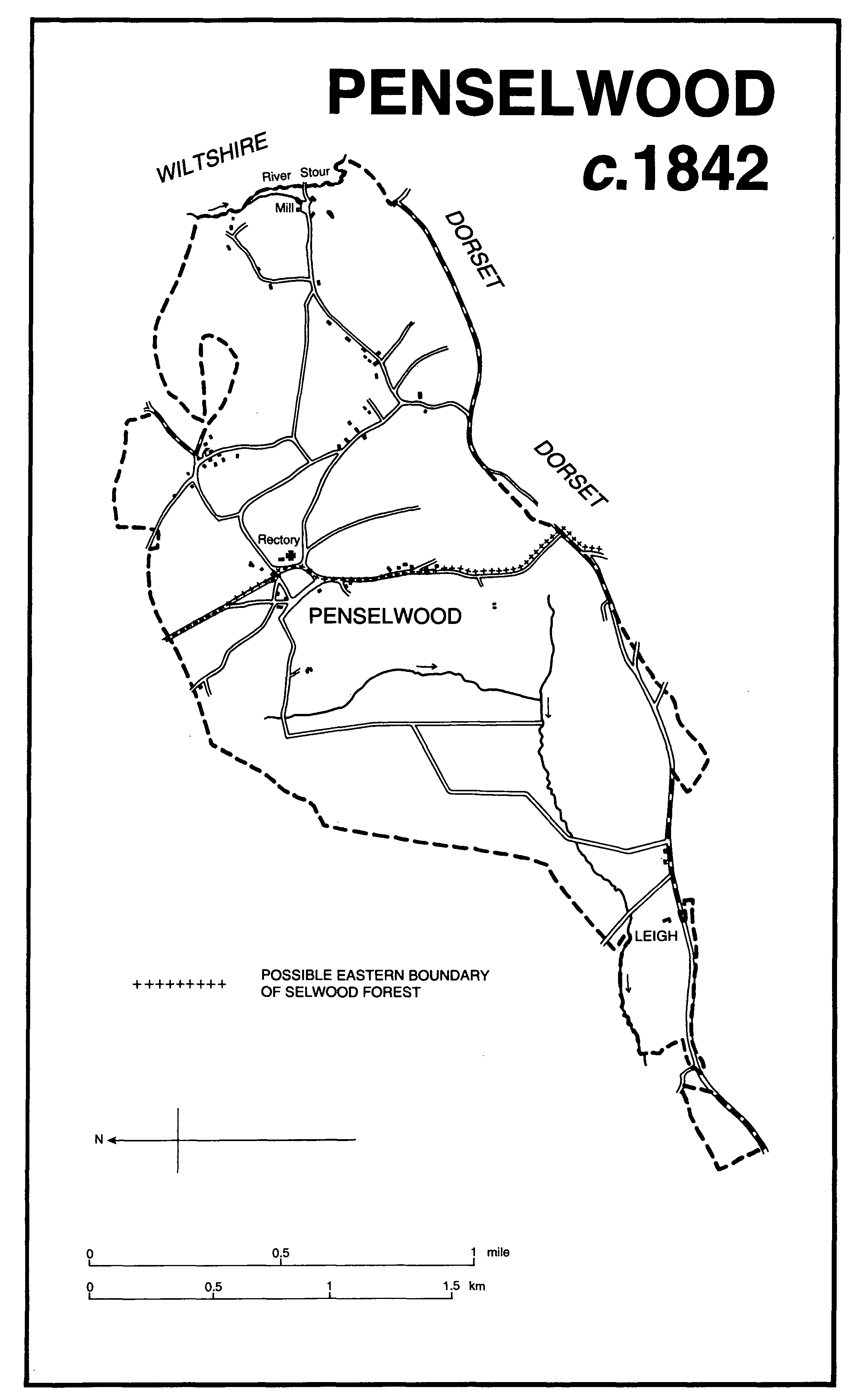
Penselwood c.1842
The ridge of Upper Greensand on which most of the parish lies reaches 210 m. on the northern boundary and 201 m. near the southern. To the east the land falls in coombes to the silty clay valley of the river Stour, which forms the boundary with Wiltshire. To the west it falls to 110 m. down a wooded scarp of clay and landslip and continues south-west over Coral Rag and Oxford Clay to include Leigh common. (fn. 7)
In the earlier 17th century the bounds of the parish were marked in the north by a ditch and what was called a barrow, and by trees, roads, ditches, a stream called 'le Backwater', stones, and the forest entrance called Trister gate. (fn. 8) The southern boundary in part is marked by Long Lane, in the mid 17th century known as the London highway (fn. 9) and the most important route in the parish. From it a road runs northwards to the church and then along the Selwood ridge. South-east from the church back towards Long Lane is Bleak Street (in 1871 Blat Street), (fn. 10) and north-east from Bleak Street's southern end towards the mill runs Coombe Street.
Evidence of early settlement has been identified in the south-western corner of the parish where a double stone bank of the Bronze Age and Iron Age is associated with several flint assemblages. (fn. 11) The land east of Penselwood village above the Stour, called Pen Pits by 1589, (fn. 12) was formerly claimed to have been a 'primitive metropolis' and later as whetstone quarries perhaps dating from the Roman period. (fn. 13) An earthwork on the western side of the parish, known as Ballands castle from the field named Ballands in which it stands, has been assumed to be a medieval motte and bailey castle, (fn. 14) but may rather have been the site of the lodge occupied by the lieutenant of Selwood forest. (fn. 15)
Settlement is scattered widely across the plateau which forms the centre of the parish. Church, former church house, and rectory house, stand near cottages dating from the 19th century. (fn. 16) The former capital messuage known as Pen House or the Great House faced the bowling green. (fn. 17) A small group of cottages lines a road leading due south from the church past Penhouse farm to the southern boundary. The main settlement in the 20th century lay along Bleak and Coombe streets. The hamlet of Pear Ash, on the northern boundary, is so named from a tree by 1619; (fn. 18) in the north-east is the almost deserted Castle Orchard, where 14 houses stood in 1871; and Pen Pits, north of Coombe Street (4 houses in 1871). Chapel Lane, leading from Bleak Street, was so named in 1871. (fn. 19) New houses were built from 1969. (fn. 20)
There appear to have been two arable fields in the parish in the earlier 17th century, (fn. 21) one in the centre called Pen field and later Great field stretching south from the church to the southern boundary; the other, known as Elworth and later as Elliotts, to the west and also reaching the southern boundary. Consolidated strips still survived in 1842. (fn. 22)
The whole of the parish was probably within the bounds of Selwood forest after 1155 but its eastern part including the main area of settlement was disafforested in 1298. (fn. 23) Disafforestation of the rest took place between 1627 and 1629. (fn. 24) Allotments north of the church and converging lanes there suggest the presence of woodland at an early date. (fn. 25)
Pen Pits, an area of 200 a. of waste (fn. 26) was largely woodland, especially oak and ash, in the 16th and 17th centuries and later became pasture. (fn. 27) That part of Leigh common, in the south-west part of the parish and adjoining Stoke Trister, was inclosed in 1821 under an Act of 1814. The area was c. 60 a. (fn. 28) A rabbit warren was mentioned in 1631 in fields attached to the mill. (fn. 29)
Most of the houses in the parish date from the early 19th century and are of local stone with tiled roofs; from the 1970s many have been extended. One house in Chapel Lane still retains a thatched roof.
There was an alehouse in the parish in 1673. (fn. 30) The Queen's Head in Coombe Street is first named in 1847 and continued in business until 1975. (fn. 31) A beerhouse, also in Coombe Street and called the King's Head, was open in 1851 and closed before 1910. (fn. 32) A third house, the Rest and Be Thankful in Pen Lane, was in business by 1871, (fn. 33) and closed in 1926. (fn. 34) The Hunter's Lodge, on the former London road at Leigh common, was built between 1842 and 1851; (fn. 35) it was open in 1992.
A feast or revel was held on 13-15 August 1798 and in 1883 on the first Sunday after 5 August. (fn. 36) It was last held in 1919. (fn. 37) Bowls were played illegally in the earlier 17th century, (fn. 38) and a field north-west of the church was named Bowling Green in 1842. (fn. 39) In 1783 mummers from the village performed at Redlynch House. (fn. 40) Fives may have been played in the churchyard. (fn. 41) A benefit society met in the village by 1847 until 1855 or later. (fn. 42)
The population rose between 1801 and 1861 from 265 to 442 and fell rapidly between 1881 and 1911 from 420 to 275. (fn. 43) A slight rise in the next twenty years was followed by a fall to 218 in 1971, but new building brought the total of those usually resident to 241 in 1981 and to 269 in 1991. (fn. 44)
(Sir) Arthur Bliss (1891-1975), the composer, lived in the parish from 1935 until 1955 in the house named Pen Pits designed for him by P. J. B. Harland. (fn. 45)
MANOR
Britnod held PENSELWOOD in 1066 and in 1086 it had become part of the estate of Roger Arundel, from whom it was held by William Geral. (fn. 46) It descended in the honor of Poorstock (Dors.) and in 1236 was among the fees of Roger Fitzpayn. (fn. 47) Roger died in 1237 and was succeeded by his son Robert (d. 1281) and his grandson, also Robert, who was lord in 1284-5 and who died in 1315. (fn. 48) No further record of the overlordship has been found.
William of Kedeford held 'la Penna' as part of his fee in 1236. (fn. 49) Richard Fromund presented to the church in 1266 and still held property there in 1274. (fn. 50) By 1284-5 he had leased it for life to Nicholas Cleymond. (fn. 51) By 1316 the tenant was William Tatifer (Tauntefere), (fn. 52) from whose family it descended by marriage to the Chiseldons. (fn. 53) Richard Chiseldon was in possession by 1342 (fn. 54) and in 1351. (fn. 55) John Chiseldon was lord by 1402 and in 1419, (fn. 56) but was dead by 1426 when his widow Elizabeth held dower. (fn. 57) Elizabeth seems to have exercised sole patronage of the living in 1427, 1429, and 1430 (fn. 58) but in 1430-1 half the manor was in the hands of William Wadham (d. 1451) and his wife Margaret, (fn. 59) daughter of William Chiseldon, (fn. 60) while Elizabeth held half the manor and a third of the advowson. (fn. 61)
William Wadham was succeeded in 1451 by his son John. (fn. 62) James Wadham, sole patron of the living in 1481, (fn. 63) is thought to have been a younger son of William. (fn. 64) Sir John Wadham, William's grandson, died in 1502. (fn. 65) Sir John's son and heir, Sir Nicholas, died in 1541 (fn. 66) and was succeeded in turn by his son John (d. 1577-8) and by John's son Nicholas. (fn. 67) Nicholas, who married Dorothy Petre and with her founded Wadham College, Oxford, died without issue in 1609, leaving three sisters as coheirs.
One third of the manor passed to Joan, wife of Giles Strangways (d. 1562) and descended successively to two grandsons, Giles (d. 1623) and Sir John Strangways (d. 1666). Sir John was followed by his second son Giles (d. 1675) and Giles by his second son Thomas. Thomas died in 1713 and his son, also Thomas, in 1726. The heirs of the last were his sisters Elizabeth (d. 1729), wife of James Hamilton, duke of Hamilton and Brandon, and Susanna, wife of Thomas Strangways Horner. Susanna's share of the manor passed on her death in 1758 to her only daughter Elizabeth, wife of Stephen Fox Strangways (cr. earl of Ilchester 1756, d. 1776) and thereafter to successive earls of Ilchester. Giles Stephen Holland Fox-Strangways, earl of Ilchester, was one of two joint lords of the manor in 1939. (fn. 68)
One third share passed to Florence, wife of John Wyndham, and descended like Orchard Wyndham (fn. 69) to Charles Wyndham, earl of Egremont (d. 1763). In 1817 his son George (d. 1837) exchanged his holding in Penselwood with the earl of Ilchester for land outside the parish. (fn. 70)
One third of the manor passed to Margaret, wife of Nicholas Martin, and was divided among her four heirs on her death in 1610, namely her daughters Elizabeth, wife of Sir Thomas Hamon, Frances, wife of Thomas White, and Anne, widow of Anthony Floyer, and her grandson (Sir) Edward Richards, son of the fourth daughter Jane. (fn. 71)
The Martin estate was subject to further division during the 17th century. Sir Edward Richards sold his share in 1632 and Sir Thomas Hamon in 1633, (fn. 72) and parts were acquired by the Wyndhams in 1660. (fn. 73) Thomas and Andrew Ewens bought Anne Floyer's share in 1632, (fn. 74) and by 1657 until after 1664 Thomas Ewens held a court in respect of one sixth of the manor. (fn. 75) In 1659 Thomas Carew was in possession of a quarter share formerly of Sir Edward Richards, (fn. 76) and in 1685 Elizabeth Matthew and James Sparrow each owned fractions, some of which passed to Edward King in 1699. (fn. 77) King, a linen weaver, owned one third of the advowson in 1705, half of which he had acquired from Robert Freke in 1698. (fn. 78) King died in 1722 and his share of manor and advowson passed to his daughter Dorothy and to her husband Henry Good. John Good, their son or grandson, sold the share to Henry Hoare in 1775. (fn. 79)
In 1685 William Biging held fractions of the manor and in 1708 the Still family conveyed more to him. (fn. 80) By 1742 Biging had accumulated twenty-two fortieths of the divided manor, largely as lessee of the Strangways share. Henry Good and Sir Charles Wyndham had nine fortieths each. (fn. 81) Biging was succeeded in 1743 by his son Harry (d. 1762) and Harry by his son William (d. 1802). By 1784 William seems to have exchanged some land with Henry Hoare, (fn. 82) and in 1845 William's widowed daughter-in-law Mary Biging sold his freehold estate to the earl of Ilchester. (fn. 83)
The Hoare share, registered in 1801 with those of the earls of Egremont and Ilchester, (fn. 84) descended from Henry Hoare (d. 1785) to his grandson Richard (cr. Bt. 1786, d. 1787). Sir Richard Colt Hoare, son of the last, died in 1838 and the share descended with the baronetcy. Sir Henry Hugh Arthur Hoare was said to be one of the two joint lords of the manor in 1939, (fn. 85) although the family had sold the land between 1875 and 1918. (fn. 86)
Pen House or Great House, the capital messuage of the divided manor and the principal house in the parish by the later 17th century, (fn. 87) belonged with the Strangways share of the estate. It was occupied by Thomas Strangways Horner at his death in 1742 and was a substantial three-storeyed house. (fn. 88) In 1751 its front was said to have been decayed and it was offered for sale. (fn. 89) The building, comprising a main range with projecting front wings, stood north-west of church and rectory house. It was still standing in 1842 and probably until later in the 19th century. (fn. 90)
Forest Lodge, (fn. 91) on an elevated site overlooking the southern part of Selwood forest, may have derived its name from and occupied the same site as the lodge attached to the forest in 1540 (fn. 92) and 1618. (fn. 93) In 1632 it was named Lodge House and stood beside land called Penne Lodge and adjoining open grassland. It was then in the custody of the king's forester. (fn. 94) The principal rooms of the present house were a three-bayed addition in front of an earlier building, possibly the work of J. K. Biging (d. 1841). (fn. 95) The older house became the service wing. Biging, his widow, and H. C. Leaver, rector 1852-77, lived there. (fn. 96) The house had to be extensively rebuilt after a fire in 1929. (fn. 97)
ECONOMIC HISTORY
There was land for 3 ploughteams in 1086 but only 2½ teams were recorded, one on the 2-hide demesne. The tenant farmers, 4 villani, 8 bordars, and 4 cottars, shared 1½ team. There were 3 beasts, 13 swine, and 100 sheep, 12 a. of meadow, and 20 a. of pasture. Woodland measured 12 furlongs in length and 4 furlongs 12 perches in breadth. The value of the estate had fallen since 1066 from £7 to £3. (fn. 98)
In the 13th and 14th centuries millstones were quarried and widely exported. (fn. 99) The quarries, stretching from the east of the village north and east into Stourton (Wilts.) and Zeals (Dors.) parishes, comprise some 20,000 pits. The taxpayers of the parish in 1327, paying half the total of Cucklington and less than Charlton Musgrove, included a shepherd, two men named from the local woodland, and two called Baller, perhaps involved in clay digging. (fn. 100)
In 1535 tithe income suggests that the cultivated part of the parish was fairly evenly divided between arable and grassland. (fn. 101) The income of the manor in the later 16th and the earlier 17th century comprised rents of over £8, varying sums from fines and other casual payments, and sometimes substantial amounts from sales of oak and ash shrouds and timber. In 1580-1 the gross income was £13 10s. 6d., in 1626-7 £64 13s. 2d. (fn. 102) In the earlier 17th century the manor amounted to 915 a. There were five freeholds of which the largest in 1631 was Leigh farm (50 a.), held by the earl of Pembroke. Just under half the total area was divided between 17 customary tenants, holding either on leases for lives or by copy. The largest tenant farm, later known as Pen farm, comprised 116 a., followed by the 70 a. held with the mill. Between them the tenant farms had just over 148 a. of arable and 109 a. of meadow. There were 200 a. of waste. (fn. 103)
Disafforestation took place between 1627 and 1629 (fn. 104) involving 300 a. in which tenants had rights of pasture over 240a. (fn. 105) After inclosure the king received one third, with the best trees, the lords one third 'to be disposed of at their pleasure', and the tenants one third. (fn. 106)
The Ewens family were prominent farmers in the 17th century. Andrew and Thomas Ewens had shares of the manor from 1632, (fn. 107) and Andrew was a leading taxpayer in 1641. (fn. 108) Thomas and Alexander Ewens each offered 40s. to the king in 1661. (fn. 109) Thomas left goods and chattels valued at £1,455 in 1685. His farm stock comprised 6 cows, 18 young beasts, 5 horses and mares, 2 colts, and a Welsh pig. Crops were hay, wheat, and oats. (fn. 110) A decade earlier another local farmer had 6 cows and calves, 10 other cattle, 13 horses, and a flock of over 100 sheep, small acreages of winter corn and oats, and evidence of cheese manufacture. (fn. 111) William Biging (d. c. 1710) and Samuel Rake were the largest tithe payers in 1707-8. (fn. 112) Rake was tenant of Pen farm and paid a total rent of £50. (fn. 113) By 1742 the Biging family held fractions of the manor and several leaseholds amounting to 113 a. together with a share in Pen farm, much of which was later mortgaged. In 1802 William Biging (d. 1802) paid a fine of £520 for renewing a lease. (fn. 114)
By 1713 the lords of the manor between them had 75 a. of woodland and the tenants 52 a. (fn. 115) In 1756 the timber on the earl of Ilchester's share comprised 446 maiden oak and ash and 1,059 pollards in an area which measured 26 a. c. 1801. (fn. 116) By 1817 the land was described as forest coppice. (fn. 117)
The regular income of the lords was not large. The earl of Ilchester's share of manor rents amounted in 1780 to just over £46, which included a small farm formerly within the forest and bought in 1764; (fn. 118) Henry Hoare's rental in 1784 was just over £25, and in 1800 £42. (fn. 119)
At the end of the 18th century the standard of farm management on the Ilchester estate was considered not high and the 'poor, cold clay' was heavily infested with weeds, (fn. 120) but the year 1801 was declared the most fruitful within living memory, although the crops on only c. 100 a. in the parish were recorded, of which 30 a. was oats, 20 a. each of wheat and potatoes, and 18 a. of barley. (fn. 121) Woodland was exploited for timber and bark in the later 18th and the early 19th century, and the oak, ash, and elm on the Ilchester estate was valued at over £635. (fn. 122) The largest farms in 1802 were Pen, followed by Penhouse, and the land attached to the mill. (fn. 123) By 1817 there were 5 farms over 50 a. in size, of which the largest, known as Whiteheads, measured 134 a., followed by Pen farm (128 a.), Sparrows (77 a.), and Pen mill (73 a.). The last three were unlet. (fn. 124) Leigh farm, which in the 1730s had been 77 a. in extent, (fn. 125) in 1829 covered 44 a. in Penselwood and 152 a. in Wincanton. (fn. 126) By 1842 three holdings measured over 100 a. in the parish and there were 306 a. under arable, 606 a. of meadow and pasture, and 89 a. of woodland, of which 51 a. lay in the area of the former forest. (fn. 127)
In 1857 the earl of Ilchester was sole owner of 144 a., joint owner with the Hoares of 126 a., and part owner with the Hoares and George and Henry Messiter of 275 a. (fn. 128) Pen farm was 192 a. in 1851, and in 1871, renamed Church farm, was 250 a. (fn. 129) In 1875 Leigh farm measured 324 a. in total, rather less than half in Wincanton, and was still part of the holding of the Hoare family. A total of 252 a. in the parish was then owned solely by Sir Henry Hoare and 254 a. jointly with the earl of Ilchester. (fn. 130) Leigh farm was sold by the Hoare family in 1918. (fn. 131)
A dairyman was recorded in 1813, (fn. 132) and two dairy farmers were in business in 1875. (fn. 133) Arable contracted between 1842 and 1905 to a total of 43 a., grassland increased to 870 a., and woodland to 106 a., the woodland mostly belonging to the earl of Ilchester. (fn. 134) In 1912 some 284 a. of Lord Ilchester's Redlynch estate in the parish, then including Manor farm (formerly Pen and Church farm) and Bleak farm, were sold. (fn. 135) Some of the Hoare estate was sold in 1914. (fn. 136) By the 1880s the largest individual landowner was W. Parsons, and his successors were Major W. P. Parsons in 1919, and the Revd. Newton Parsons in 1939. (fn. 137) There were nine separate farms in 1939, the largest at Pear Ash. (fn. 138) In 1988 there were 11 holdings, measuring 30 ha. or less and only two over 50 ha. Among them were three dairy farms, one poultry farm, and one rearing cattle and sheep. Less than 15 ha. in the parish was arable. (fn. 139)
Textile production is first traced in the parish in 1664 when a hosier from Mere (Wilts.) took over the corn mill. (fn. 140) A dyer was working in the parish in 1783. (fn. 141) About 1811 the mill was processing flax for Daniel Maggs, a tick maker, and his brother Michael. (fn. 142) In 1839 26 people were employed there, (fn. 143) and in 1851 19 people from the parish including children. (fn. 144) In 1861 21 were employed there while others from the parish worked at the linen factory at Bourton. (fn. 145) Dressed flax, sackcloth, twine, and shoe thread were produced until the early 1880s. (fn. 146) Other textile workers living in the parish included woolcombers and hosiers between 1817 and 1854, and in 1861 a hosier master and a worsted manufacturer were living there. (fn. 147) In 1861 there were three shops and craftsmen included two masons and a carpenter. (fn. 148) There were still three shops in 1906 but only one in 1939. (fn. 149)
Apart from millstones, (fn. 150) limestone was quarried from the earlier 17th century (fn. 151) and was burnt in the 19th. (fn. 152) A quarry was in operation in 1939. (fn. 153)
Mill
There was a mill in 1086. (fn. 154) A corn mill is mentioned in 1586-7 (fn. 155) and in 1618 it was held with a farm of 60 a. (fn. 156) In 1664 it was let to a hosier and continued to produce textiles until the early 1880s. By 1883 it was again a water grist mill and was in business in 1891, but had probably ceased to grind by 1902. (fn. 157)
In 1639 the mill house was described as good and the holding included a garden, orchard, and 70 a. of good land. (fn. 158) In the 19th century the mill was driven by water feeding a pond to the south which then passed underground to a second pond to the north. (fn. 159) A long leat has subsequently been constructed running parallel to the river Stour but flowing in the opposite direction. (fn. 160)
LOCAL GOVERNMENT
The parish formed a single tithing by the early 13th century and remained so in the 16th. (fn. 161) A single court for the vill in 1540 imposed fines on a woman for being a scold and on a man for allowing his dog to bite a mare. (fn. 162) After the division of the manor the Wyndhams usually held courts, described as courts baron, in the spring, and the Strangways family (jointly with Thomas Ewens in 1657 and 1664) in the autumn. Rolls and papers survive for 1632, (fn. 163) 1637, (fn. 164) 1657-9, (fn. 165) 1664, (fn. 166) for most years between 1682 and 1710, (fn. 167) and for 1714, 1738, and 1782. (fn. 168) In the later 16th and the earlier 17th century the court licensed customary tenants to live away from the manor. (fn. 169) Business of the court in the 17th century included orders to repair buildings and implements, to control strays, and to organize common grazing. By 1631 the tenant of Pen farm was required to provide hospitality for the lord or his steward. Another house, leased by the Strangways family in 1698, was to be used by them or their stewards. (fn. 170)
The parish appointed two wardens, two overseers, (fn. 171) and two highway surveyors or waywardens. (fn. 172) In the 1790s the vestry nominated both wardens as well as overseers. (fn. 173)
In the 18th century the poor were offered monthly payments and the cost of clothing or thatching their houses. A poorhouse had been established in the former church house by 1775, for part of which in 1792 the wardens were paying rent to the lords of the manor. (fn. 174) In 1844 the vestry proposed to repair and relet the former parish portion which in 1846 was conveyed by the poor-law guardians to the rector and wardens. In the previous year the lords of the manor had conveyed the rest to the rector and wardens, both transactions allowing the whole building to be converted to a parochial school. (fn. 175)
The parish became part of the Wincanton poor-law union in 1835, Wincanton rural district in 1894, and Yeovil, later South Somerset, district in 1974. (fn. 176)
CHURCH
The font, the south doorway, and the proportions of the nave and chancel suggest a church of the 12th century. (fn. 177) The living was a sole rectory until 1980 and from that date formed a plurality with Wincanton. (fn. 178)
Successive lords of the manor held the advowson from 1266, (fn. 179) but a lessee presented in 1325, (fn. 180) and in 1595 John, William, and Edmund Waddesworth were patrons by grant of Nicholas Wadham. In 1623, after the division of the manor, Richard Willoughby of Silton (Dors.) was patron, presumably as grantee of one of the lords, but John Strangways, lord of a third of the manor, presented in 1628. (fn. 181) Sir John Wyndham, who owned the next presentation, granted it to Andrew Ewens in 1633, (fn. 182) and Ewens presented in 1645. The new rector agreed not to resign without first informing Wyndham. (fn. 183) The next presentation is recorded as having been made by Sir William Wyndham and Thomas Ewens, (fn. 184) but was in fact made by the lords of that third of the manor then largely owned by Thomas Ewens, William Still, Thomas Carew, and John Sparrow in which Sir William also had a small share. An attempt to present another man evidently received some local support. (fn. 185)
Thomas Ewens presented in 1674 but there was opposition from the Wyndhams when Thomas Strangways presented in 1719. (fn. 186) Henry Good the younger was patron in 1744 as owner of part of the divided third share of the manor. (fn. 187) The earl of Egremont presented at the next vacancy in 1791 and the earl of Ilchester in 1806. (fn. 188) In 1921 the earl of Ilchester had transferred his turn to the bishop of Bath and Wells and the bishop exercised the patronage at two vacancies in every three. In 1959 the Hoare trustees made over their share to the bishop, leaving him sole patron. (fn. 189)
The living was taxed at £4 in 1291, (fn. 190) at £5 by 1445, (fn. 191) and at £6 13s. 9d. net in 1535. (fn. 192) In 1708 it was valued at £47 1s. 4d. net. (fn. 193) The income of £297 in 1931 included payments of £36 from Queen Anne's Bounty and £82 from the Ecclesiastical Commissioners. (fn. 194)
Tithes amounted to £3 10s. in 1535, (fn. 195) and to £29 7s. 4d. in 1708. (fn. 196) They were commuted for £61 12s. 8d. in 1842, (fn. 197) and in 1851 were worth £160. (fn. 198) Glebe, valued at 29s. in 1535 (fn. 199) and £50 c. 1670, (fn. 200) was reckoned at 33 a. in 1606 and at 28 a. in 1708. (fn. 201) In 1842 there were 47 a. (fn. 202) Nearly 30 a. were sold in 1921 but a small plot was bought in 1928, (fn. 203) leaving just over 19 a. (fn. 204)
There was a parsonage house in 1606. (fn. 205) In 1815 it was described as unfit and very small, and in 1840 was uninhabited but under repair. (fn. 206) It continued to be let until after 1871. (fn. 207) It was rebuilt, on a larger scale, in the later 19th century, was divided in 1951, and was sold in 1980. (fn. 208)
In 1325 Hugh of Bourton was licensed soon after his appointment as rector to be absent in the service of the queen's sister. (fn. 209) In the 1530s a rector and a curate served the parish and there were six altars, lights, or images in the church and an endowed obit. (fn. 210) William Ashley, rector 1665-74, was resident rector of Cucklington with Stoke Trister and employed a curate at Penselwood. (fn. 211) Richard King, rector 1745-91, and Charles Digby, rector 1806-32, both employed the rector of Stourton (Wilts.) as curate. (fn. 212) From 1822 the curate was J. K. Biging, who himself was rector 1832-41 and also served Bourton (Dors.). (fn. 213) Samuel Merindin, rector 1841-52, was also rector of Buckhorn Weston (Dors.) and employed resident curates at Penselwood. (fn. 214) On Census Sunday 1851 the morning congregation was 107, of whom 50 were adults; in the afternoon there were 120 adults and 50 children. The curate believed open beershops the reason for the small morning congregation. (fn. 215) By 1870 there were monthly celebrations of communion. (fn. 216) A choir had been introduced by 1871. (fn. 217)
By 1889 there was a mission church in Coombe Street owned by Mrs. Austen, wife of E. G. Austen, rector 1887-99. It was sold by her before 1900. (fn. 218)
There was a church house by 1611. (fn. 219) It stood beside the churchyard and was evidently rebuilt in the later 18th century. It was last so named in 1784 but was already a poorhouse. (fn. 220)
The church of ST. MICHAEL, so dedicated by 1546 (fn. 221) and built of rubble with ashlar dressings, comprises a chancel with north vestry, a nave with north aisle and south porch, and a west tower. The reset south doorway of the small nave has a carved lintel and a chevron-decorated arch above a plain tympanum. There is a 14th-century piscina in the chancel and the tower is of the 15th century as are the much-restored windows of the chancel. In 1805 the nave walls were raised in height, new windows inserted, and a new ceiled roof built. (fn. 222) The north aisle and vestry were added in 1847-8 to the designs of Jesse Gane of Evercreech. Gallery and box pews were then removed, and the chancel and nave rebuilt. (fn. 223)
The head of a late-medieval churchyard cross is in a niche over the south porch. (fn. 224) The three medieval roof bosses in the nave came from Stavordale priory in 1874. The pew ends were carved in 1927 by Mrs. Clemency Angell. (fn. 225)
The plate dates from 1843. (fn. 226) There are six bells including one from a Dorset foundry of c. 1500 and said to have come from Stavordale, and one of 1520 by Thomas Jeffereys of Bristol, formerly at Charlinch and added in 1985. Another is dated 1584. (fn. 227) The registers date from 1721 but are incomplete. (fn. 228)
NONCONFORMITY
One man was fined for recusancy in 1593-4 and was reported again in 1604 and 1612. (fn. 229) One woman in 1629 was described as a popish recusant and excommunicate. (fn. 230)
A house was licensed in 1842 for use by dissenters. (fn. 231) Primitive Methodists were building a chapel in 1860. (fn. 232) Closed in 1954, it was sold in 1956 (fn. 233) and later demolished. (fn. 234)
EDUCATION
A church Sunday school opened in 1829 had 40 children in 1833 and was supported by subscriptions. There were also in 1833 two day schools teaching a total of 27 children at their parents' expense. (fn. 235) By 1846-7 there was a National school which had 40 children on weekdays and Sundays and 24 on Sundays only. (fn. 236) A new school was built in 1847 on the site of the former poorhouse (fn. 237) which was enlarged in 1882 and 1926. (fn. 238) In 1903 there were 43 children on the books. (fn. 239) The average number in 1935 was 37 but attendance was much less. (fn. 240) The school, which received pupils from Southampton in 1940, closed in 1946 and the children were transferred to Bourton (Dors.). (fn. 241) The Primitive Methodist Sunday school started in 1863 had 18 teachers and 82 children in 1865 and 55 children in 1890. (fn. 242)
CHARITIES FOR THE POOR
Walter Kelly (d. 1930) gave £50 to the rector and churchwardens for the parish and for the benefit of the poor, and Cyril Leaver (d. 1931) bequeathed £500 in trust for the sick and poor. (fn. 243)