A History of the County of Cambridge and the Isle of Ely: Volume 10, Cheveley, Flendish, Staine and Staploe Hundreds (North-Eastern Cambridgeshire). Originally published by Victoria County History, London, 2002.
This free content was digitised by double rekeying. All rights reserved.
A F Wareham, A P M Wright, 'Horningsea', in A History of the County of Cambridge and the Isle of Ely: Volume 10, Cheveley, Flendish, Staine and Staploe Hundreds (North-Eastern Cambridgeshire)(London, 2002), British History Online https://www.british-history.ac.uk/vch/cambs/vol10/pp160-163 [accessed 1 May 2025].
A F Wareham, A P M Wright, 'Horningsea', in A History of the County of Cambridge and the Isle of Ely: Volume 10, Cheveley, Flendish, Staine and Staploe Hundreds (North-Eastern Cambridgeshire)(London, 2002), British History Online, accessed May 1, 2025, https://www.british-history.ac.uk/vch/cambs/vol10/pp160-163.
A F Wareham, A P M Wright. "Horningsea". A History of the County of Cambridge and the Isle of Ely: Volume 10, Cheveley, Flendish, Staine and Staploe Hundreds (North-Eastern Cambridgeshire). (London, 2002), British History Online. Web. 1 May 2025. https://www.british-history.ac.uk/vch/cambs/vol10/pp160-163.
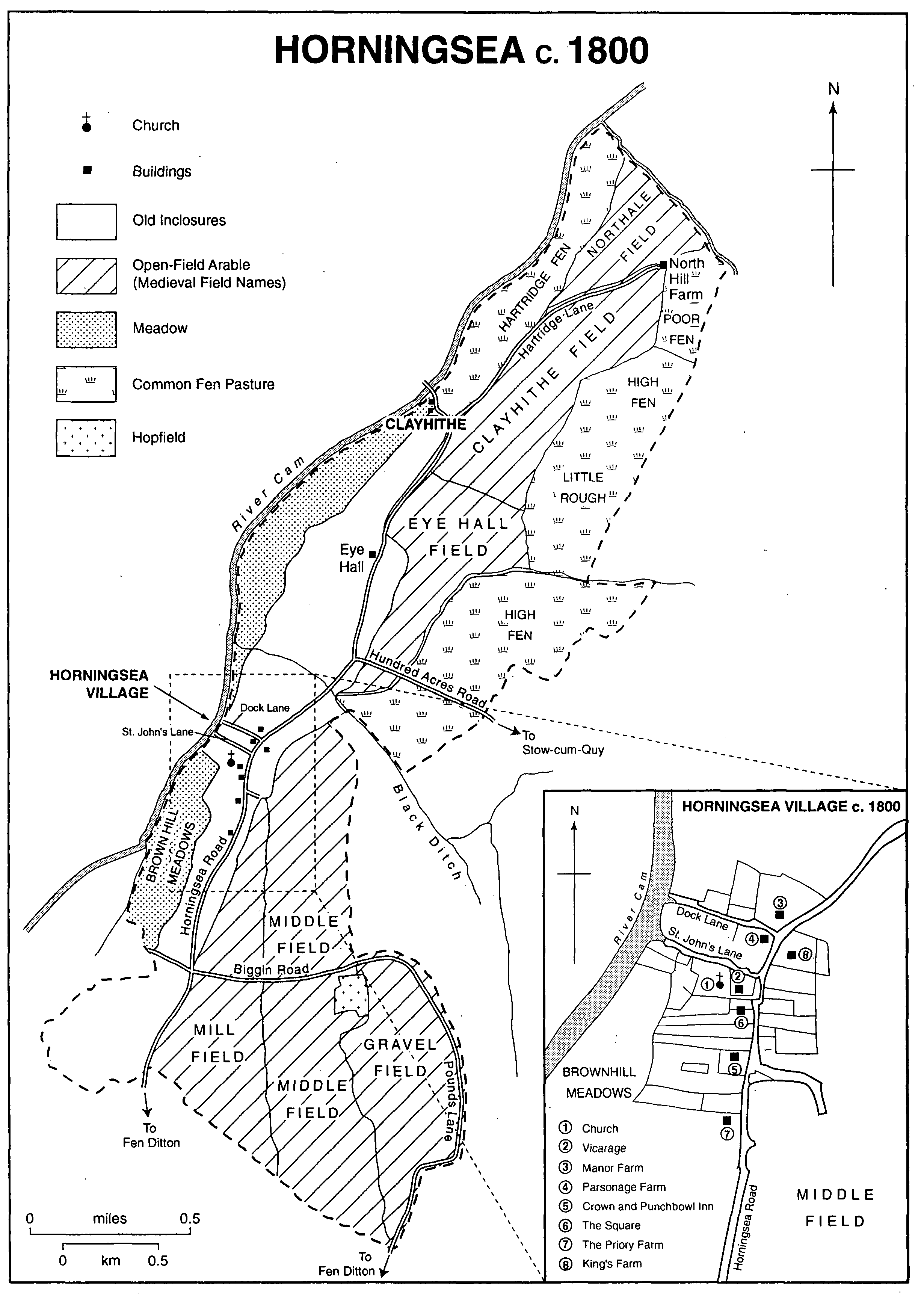
HORNINGSEA
The parish of Horningsea, which takes its name from the Old English word for hill and island, lies 6 km. (3½ miles) NNE. of Cambridge. (fn. 1) It comprises a long strip of territory covering 1,167 a. (655 ha.) on the eastern bank of the river Cam, (fn. 2) the southern half of which is roughly triangular in shape, the northern half rectangular. The parish's western boundary mostly follows the western bank of the river Cam on its course north-eastwards as far as Bottisham lock. From there it runs south-eastwards along Bottisham lode, then turns south-west to follow a straight line to Fencett farm. Thereafter the irregular eastern boundary interlocks with Fen Ditton's boundary, which was fixed in 1412. (fn. 3) The triangular southern half of the parish, some 6 m. (20 ft.) above sea level, lies upon a continuation of the tongue of Lower Chalk which stretches northwards from the north end of Fleam Dyke. In the northern half of the parish gault and clay overlay Cambridge Greensand, and the elevation is less than 6 m. (20 ft.) above sea level. Along the banks of the river Cam there are alluvial river gravels, and in the northwestern triangular tip of the parish, between North Hills, Bottisham lode, and the Cam, peat overlies Cambridge Greensand. (fn. 4)
During the 2nd millennium B.C. what became Horningsea stood on a chalk promontory between tidal water and marsh, and in the early Middle Ages the parish comprised an elongated peninsula jutting northwards into undrained fenland. (fn. 5) The earliest drainage was through Bottisham lode, which formed part of a series of watercourses that were cut in the Middle Ages or earlier across the fens to the river Cam. In 1637 the earl of Bedford and the Adventurers were allotted 400 a. (c. 165 ha.) of fen in the parishes of Fen Ditton, Horningsea, and Stow cum Quy. (fn. 6) In the 1640s and the mid 1650s Horningsea and Fen Ditton fens were drained by digging a main watercourse that connected to Bottisham lode. In 1758 landowners in Horningsea and Bottisham were required to pay half of the costs of repairing Bottisham lode sluice, and of sealing a breach in the east bank of the Cam between Clayhithe and Upware, but in 1766 the drainage in the region was regarded as inadequate. (fn. 7) In the early 1790s Horningsea's fields were drained by cutting small hollows 1.5 m. below the bottoms of the furrows. During the 19th century the remaining fenland in the parish was drained, (fn. 8) except for the area around Snout's corner, which was still fenland in 2000.
The Cam was used for waterborne transport during the Roman period, and in the Middle Ages. (fn. 9) In the 16th century the watercourse at Clayhithe was maintained by the authority of Eye Hall manor court. (fn. 10) The charter of incorporation granted to the earl of Bedford and the Adventurers for drainage included the right to levy tolls on boats passing through the sluices. (fn. 11) In 1700 a series of locks began at Bait's lock and ended further north at Clayhithe, but there were obstructions downstream, and in 1703 Conservators of the River Cam were appointed to improve navigation. (fn. 12) Further improvements were implemented in 1792 and in 1812-13. (fn. 13) In the late 19th century lighters were still in use between Horningsea and King's Lynn (Norf.). (fn. 14)
A bridge was mentioned at Horningsea in the late 13th century. (fn. 15) The ferry crossing at Clayhithe, where firm ground reaches the river, was first recorded in the 1330s. (fn. 16) Ownership of the ferry descended with Eye manor, whose lord leased it with a ferryman's cottage c. 1430. (fn. 17) It was still in use in the late 1860s, (fn. 18) but was replaced in 1872 by an iron tollbridge, administered by the Clayhithe Bridge Company. (fn. 19) In 1898 there were complaints about the toll, and in 1938 the county council bought the bridge, and freed it from tolls. (fn. 20) The bridge, rebuilt in 1939, has remained in use throughout the 20th century.
Horningsea c. 1800
In the Middle Ages the old Horningsea road linked Cambridge, Fen Ditton, Horningsea, and Clayhithe. From the Middle Ages until the early 19th century, the northernmost section lay to the west of Eye Hall, but at inclosure in 1810 its route was shifted to the east of Eye Hall. Traces of the medieval route are still visible. (fn. 21) In 1810 the southern section running between Horningsea and Fen Ditton villages was straightened. (fn. 22) From the 13th century, a road running north-eastwards from Clayhithe to Northfields, later known as Hartridge lane, was used as a droveway. (fn. 23) Hundred Acres lane ran south-eastwards from the mid-point of Horningsea road towards Teversham. Biggin Road, a medieval route, (fn. 24) ran eastwards through the southern portion of the parish, crossing Horningsea Road and continuing southwards as Pound Lane, so named in 1791, but later known as Low Fen drove. (fn. 25)
In 1978 the northern section of the Cambridge bypass, begun in 1976, was completed; it ran eastwards from Poplar Hall through the southern section of the parish and the adjoining part of Fen Ditton. (fn. 26) Slip roads connected the bypass to Horningsea Road, bringing increased traffic through both Horningsea and Fen Ditton parishes. The inhabitants of Fen Ditton campaigned vigorously for the closure of the slip roads between 1984 and 1996, but there was some opposition to this because Ansells Garden centre and the village shop in Horningsea depended upon the connection for their continued prosperity. In 1988 traffic-calming measures along the Fen Ditton stretch of Horningsea Road achieved the desired effect during the day. Unexpectedly, however, night-time drivers from neighbouring parishes treated that stretch of the road as a racetrack chicane, causing 18 accidents between 1988 and 1992.
There was settlement along the fen edges of Horningsea in the Iron Age, but otherwise evidence for early settlement comprises only a few prehistoric finds. (fn. 27) Between the 1st and 3rd centuries A.D. a 2-ha. settlement, comprising a single inclosure within three ditches with an entrance in its north-western corner, stood to the south of the site of the 2nd-century limekilns. (fn. 28) In 1086 there were 51 peasant households at Fen Ditton and Horningsea, and in 1279 there were c. 90 landholders in Horningsea alone. (fn. 29) In 1563, 1664, and 1674 there were c. 32 households in the parish. (fn. 30) Forty-five families were reported in 1728. (fn. 31) The population had risen to 293 by 1801, and after falling to 233 in 1811 recovered to 285 in 1821. (fn. 32) In 1841 it stood at 295, and, despite some emigration to Australia, (fn. 33) numbers increased to 371 in 1851 and 433 in 1871. Between 1871 and 1891 the population remained stable, but by 1901 had declined to 386, falling further to 312 before the Second World War. Between 1961 and 1971 it again fell sharply from 355 to 274, rising to 333 in 1981. In 1991 there were 336 inhabitants.
The medieval settlement of Horningsea developed along the river, (fn. 34) but the character of the village is predominantly early 19th-century, when locally made brick was widely used in its buildings. (fn. 35) Along Horningsea Road (High Street) most of the houses date from the 19th and 20th centuries, with earlier development along the two side-lanes which run westwards from Horningsea Road towards the river Cam. The farmhouses are the most prominent buildings in the parish.
On the High Street three buildings dating from before 1800 are worthy of note. A 16thcentury, timber-framed, two-storeyed house named the Priory stands on the south-western section of the street, and two 17th-century residential buildings stand on the western side of Horningsea Road, one of which, named the Square, is timber-framed and two-storeyed with attics. (fn. 36) Dock Lane, the more northern of the two side-lanes, is lined by thatched cottages and barns. At the river end of Dock Lane, there stands a cottage, possibly 16th-century, with a thatched gabled roof and brick casing, which originally had an open hall. Manor Farm stands at the north-eastern point of Dock Lane, where it meets the High Street. The farmhouse originated in the 17th century, but was enlarged and re-orientated in the 19th century, possibly in 1843, when the stable block was also added. (fn. 37) St. John's Lane has buildings which range in date from the turn of the 16th century to the late 20th century. Parsonage Farm, on the northern side of the lane, was standing by 1599, but underwent several alterations in the 18th and 19th centuries. (fn. 38) It has a six-bayed barn which may have been built in the 18th century. (fn. 39) In the 1880s three quarters of the houses in the parish stood in Horningsea village. (fn. 40) Council houses were built east of High Street c. 1930, and after 1945 the Priory council estate was built west of High Street, raising the number of houses to 120 in 1961. (fn. 41) In 1973, on land adjoining the Priory estate, a number of 19th-century cottages were rebuilt, enlarged or replaced in the style of Victorian terraces, as part of The Square development. (fn. 42) In 1988 two fifths of the adult population of Horningsea lived on the estates grouped around Priory Road.
Eye and Clayhithe, recorded in the 10th century, (fn. 43) were dependencies of Horningsea in 1279. (fn. 44) Earthworks around Eye Hall may indicate a deserted medieval settlement. (fn. 45) One medieval house was possibly deserted in the 16th century, and a small building, formerly thought to be Roman, was constructed on the site only in the 18th century. (fn. 46) There was infilling on Clayhithe Road in the late 19th century, including a cottage and a smithy near a brickyard. (fn. 47)
There were three public houses in 1764. (fn. 48) The Sluice at Clayhithe, serving river traffic, probably closed soon after 1827. (fn. 49) The Chequers, first mentioned in 1805, (fn. 50) was used as the meeting place of the local branch of the Ancient Shepherds in 1850. (fn. 51) In 1873 as a result of the rowdiness of the coprolite diggers public houses closed early, (fn. 52) and since 1881 there have only been two pubs in the parish and village, (fn. 53) namely the Crown and Punch Bowl inn, in a 17thcentury building, recorded from 1764, (fn. 54) and the Plough and Fleece, occupying a timber-framed, 16th-century building. (fn. 55)
Between 1855 and 1865 there was an annual ploughing match between the inhabitants of Fen Ditton and Horningsea. (fn. 56) In the late 1860s a modest village feast was held on the fourth Sunday after Trinity. (fn. 57) Between 1927 and the early 1970s there were allotment gardens southeast of the village. Since 1953 the Cambridgeshire Harriers have met each year at Manor Farm for their Boxing Day hunt, while Clayhithe was a popular site for picnics from the early 1960s. (fn. 58) In spite of the fact that the High Street is a busy road, the parish has retained the sense of an independent fenland community.