A History of the County of Cambridge and the Isle of Ely: Volume 10, Cheveley, Flendish, Staine and Staploe Hundreds (North-Eastern Cambridgeshire). Originally published by Victoria County History, London, 2002.
This free content was digitised by double rekeying. All rights reserved.
A F Wareham, A P M Wright, 'Chippenham', in A History of the County of Cambridge and the Isle of Ely: Volume 10, Cheveley, Flendish, Staine and Staploe Hundreds (North-Eastern Cambridgeshire)(London, 2002), British History Online https://www.british-history.ac.uk/vch/cambs/vol10/pp370-374 [accessed 30 April 2025].
A F Wareham, A P M Wright, 'Chippenham', in A History of the County of Cambridge and the Isle of Ely: Volume 10, Cheveley, Flendish, Staine and Staploe Hundreds (North-Eastern Cambridgeshire)(London, 2002), British History Online, accessed April 30, 2025, https://www.british-history.ac.uk/vch/cambs/vol10/pp370-374.
A F Wareham, A P M Wright. "Chippenham". A History of the County of Cambridge and the Isle of Ely: Volume 10, Cheveley, Flendish, Staine and Staploe Hundreds (North-Eastern Cambridgeshire). (London, 2002), British History Online. Web. 30 April 2025. https://www.british-history.ac.uk/vch/cambs/vol10/pp370-374.
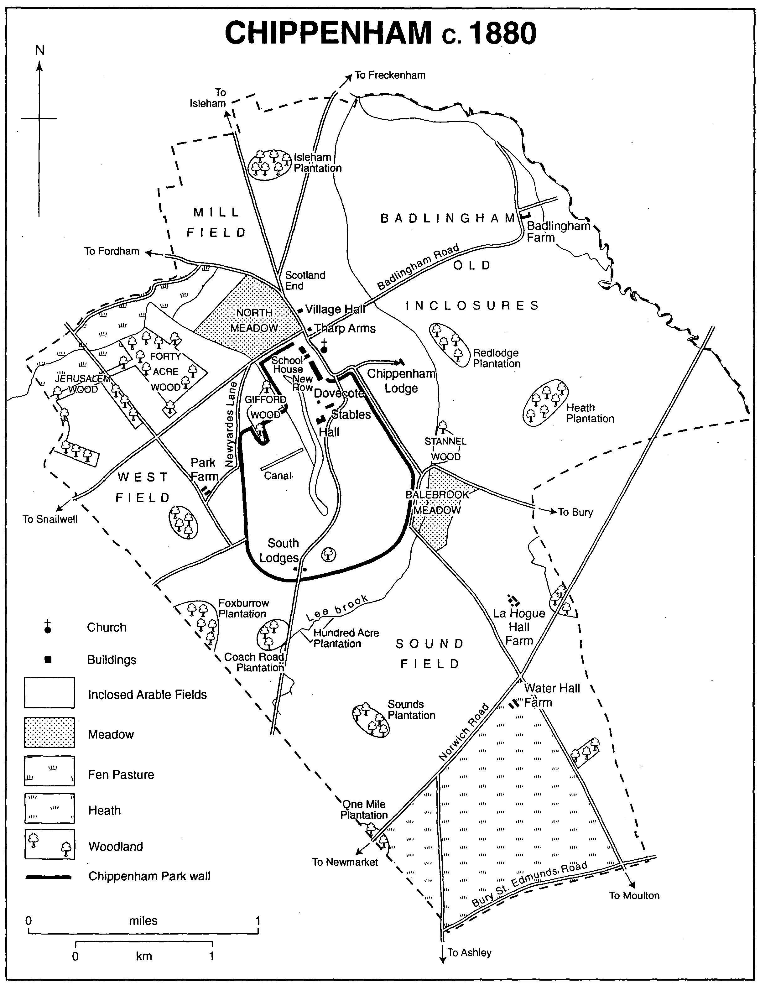
CHIPPENHAM
Chippenham, (fn. 1) lying 3½ miles (6 km.) northeast of Newmarket (Suff.) and 10 miles (16 km.) north-east of Cambridge, is a middle-sized parish of c. 4,300 a. (1,740 ha.). It lies in a projection of the county which stretches eastwards into Suffolk, and comprises the medieval township of Chippenham itself with c. 3,200 a., and to the east Badlingham hamlet with c. 1,100 a. Orientated towards the north-west, the parish is approximately rectangular in shape except to the south-east, where Kennett had been detached by 1086. Chippenham's western boundary was straightened in 1801. On the north-east the edge of the parish curves gently southwards to meet the river Kennett which forms the eastern boundary and marks the county boundary with Suffolk. Further south the parish boundary cuts back westwards away from Kennett. The southern border, following the Icknield way, is also the county boundary. Lower Chalk, which runs from north-west to south-east, is overlaid in the southern quarter of the parish by a light driving sand forming the heathland, and in the rest of the parish by river gravels and a deep white loam, including glacial deposits. (fn. 2) In the northwest in the fen a peat bed of a few cm. to 2 m. in depth overlies a layer of boulder clay, which separates it from the chalk bed. The ground falls northwards, at first steeply from 50 m. to 30 m., but has a more shallow gradient thereafter.
There are two watercourses. Lee brook rising 600 m. east of the middle of the western parish boundary flows northwards through the centre of the parish to converge with the Kennett in the east part of the northern boundary. Another stream starts at the angle of the northern and western boundaries, and flows into Chippenham fen. Chippenham lake in the western part of Chippenham Park is man-made. Both the land between Lee Brook and the Kennett, and Chippenham fen, were subject to flooding in the 19th and 20th centuries. In the northern section of the parish there is a central plateau at 15 m., where settlement has been concentrated since Mesolithic times. Chippenham Park, created by Lord Orford (d. 1727), and owned by members of the Tharp family from 1791, has dominated the parish's landscape since the 18th century.
No ancient woodland survived, but Lord Orford planted c. 36,000 quicksets for hedging, c. 5,000 crab apple trees, and c. 280 elms between 1696 and 1718. (fn. 3) Between 1793 and 1810 about two million oaks, beeches, elms, chestnuts, spruces, and Scottish firs were planted by the Tharps. (fn. 4) In the 1790s villagers ripped out trees, and a tenant challenged his landlord's rights to plant trees on leased farmland, but between 1810 and 1827 c. 10,000-27,000 trees were planted each year. (fn. 5) By 1841 there was a scatter of plantations, comprising 248 a., across the northern and eastern portions of the parish. (fn. 6) Replanting in the 19th and 20th centuries has maintained the landscape of clusters of woodland.
Chippenham fenland occupies a depression in the north-west. In the 16th and 17th centuries it comprised c. 250-300 a., and in 1544 included two lakes, possibly created through turf cutting. (fn. 7) In 1630 villagers prevented the lord of the manor from draining the fen. (fn. 8) By the late 18th century a watermill ineffectively drained the fen through Fordham. (fn. 9) The fen was inhabited by snipe, wild ducks, and herons. (fn. 10) Although not covered by the inclosure Act of 1791, the fen was inclosed in 1796, and by 1803 John Tharp (d. 1804) had cut drains with sluices along its northern and western borders, lowering the water level by 1.5 m. (fn. 11) Following effective drainage works of the early 19th century, draining was neglected c. 1860-1910, but was renewed c. 1910-50, with new drains being cut in 1943. (fn. 12) The woods by the fen provided shelter for game, and rare insects were collected in 1890. (fn. 13) The fen was noted as a site of botanical importance between the First and Second World Wars, and in 1963 the Chippenham Park estate transferred 230 a. of fenland to the National Trust for preservation. (fn. 14) In 1980 Chippenham's fenland provided one of the few natural habitats in the British Isles for Cambridgeshire parsley and Marsh Louse Wort plant. (fn. 15)
Bronze-Age barrows in groups on the southern 30-m. and north-eastern 15-m. contour lines, aligned on a northward axis, have been worn down. (fn. 16) At the southern site, near Water Hall farm, three of the six barrows, of c. 35-40 m. across by c. 1 m. high, were created from natural chalk mounds, possibly of glacial origin. One barrow, with five inhumation graves, contained five skeletons of women aged 20-50, three of men aged 18-35, and three infants. At the northern site overlooking the confluence of Lee brook and the Kennett there were three barrows. The smallest barrow, 20 m. across, may have been constructed in the Megalithic period, and the largest, 47 m. across, overlay nine Beaker period hearths. An IronAge village and later an Anglo-Saxon cemetery lay west of the northern barrows. A late Bronze-Age foundry stood where the present Badlingham Road crosses Lee brook, and there were several barrows south-west of the village in the 10th century.
Chippenham c.1880
In 1086 there were 69 peasant households at Chippenham and Badlingham, and by 1279 the two settlements had 163 landholders. (fn. 17) There were 45 tax-payers in 1327 at Chippenham. (fn. 18) Badlingham hamlet had 12 tax-payers in 1327, and 34 in 1334. (fn. 19) In 1377 204 adults paid the poll tax at Chippenham. (fn. 20) There were c. 75 households at Chippenham and Badlingham c. 1664-74, and in 1712 there were at least 50 households at Chippenham. (fn. 21)
Between 1801 and 1851 the population of the whole parish increased from 524 to 811. (fn. 22) There were substantial increases c. 1801-11, c. 1821-31, and c. 1841-51, but the population was almost stable in the intervening decades. In 1852 five per cent of villagers were aged over 75. Emigration to North America contributed to a population decline from 800 persons in 1852 to 500 to 1901, (fn. 23) but the pace of decline then slackened, with 392 inhabitants in 1931. By 1951 the population had increased to 437, but between 1961 and 1981 it fell from 361 to 312. By 1991 it had increased to 394 persons, and was still growing in the 1990s.
The prehistoric Icknield way may have been in use in the Roman period, and Street way, which ran 3 km. to the north of it, may have been straightened. (fn. 24) Ditch way, which ran between those two routes, was probably a sunken road. The road from Newmarket to Bury St. Edmunds (Suff.), which runs 80 m. to the north of the original Icknield way, was a major route c. 1604-1712, and a turnpike c. 1807-71, with the Chippenham section being let out to an association in 1830. (fn. 25) From 1604 or earlier the Norwich road, formerly Brandon way, ran north-eastward c. 1-2 km. to the north of the Bury road, dividing Chippenham's fields from its heathland. (fn. 26) Local routes ran from Chippenham village south and south-east to Ashley, Cheveley, Kennett, Moulton (Suff.), and Newmarket. (fn. 27) The Newmarket way was converted into a private drive within Chippenham Park 1712 × 1793, but in the 20th century it and other southern routes were abandoned, except for the Kennett Road and Moulton Road, renamed La Hogue Road in 1952. (fn. 28) The Newmarket bypass was built c. 1972-5, running south-eastwards in a cutting through the south of the parish. (fn. 29)
In the north, three roads running from west to east connected Snailwell, Chippenham, and Badlingham. Leave was granted to Lord Orford in 1701 to block off the eastern ends of Port Way, which ran along the line of the ancient Street Way and Middle Way. (fn. 30) Newyards Lane, the most northern route, continued beyond the village street as the Badlingham road. At a junction at the northern end of the village street, called Scotland End by c. 1841, (fn. 31) roads forked northwards, one leading north-west to Fordham, others northwards to Isleham and to Freckenham (Suff.). In 1952 the road running alongside the north-east edge of Chippenham Park was renamed Palace Lane, after a former episcopal residence, and the road between Chippenham and Snailwell, formerly Newyards Lane, was renamed Snailwell Road.
The Newmarket to Bury St. Edmunds railway line, completed in 1854, runs 1 km. north of the Bury road. (fn. 32) Although the villagers used Kennett station, (fn. 33) tradition has it that the owners of Chippenham Park had in the late 19th century enjoyed a private stopping point, where the modern La Hogue Road crosses the line. After 1965, with the withdrawal of passenger trains to Bury St. Edmunds, villagers became dependent upon bus services. (fn. 34) In 1977 buses ran regularly to London, and between 1977 and 1997 buses to Newmarket were increased from two to three a week. (fn. 35) In 1991 a tenth of households had no car at all, but 44 per cent had two or more cars. (fn. 36)
The medieval township of Chippenham stood in the centre of the northern part of the parish to the south of the Bronze-Age barrows and Anglo-Saxon cemetery. (fn. 37) The main street, 1¼ km. long, ran northwards from the junction of Moulton and Ashley roads to a fork at Scotland End, crossing Port Way, Middle Way, and Newyards Lane at crossroads in the south; middle, and north of the village respectively. The parish church stood in the middle of that main street, on its eastern side. In the late 13th century dwellings on the main street were over crowded, with crofts being sub-divided, and houses apparently stood along the western section of Street way, named South Street, and on Newyards Lane. (fn. 38) In 1446 part of the village was burnt down, and in 1544 there were 62 abandoned crofts and only 60 houses, with no dwellings left along Newyards Lane. (fn. 39) In 1674 in Chippenham and Badlingham, in addition to the two manor houses and a rectory house, 34 houses had one hearth, 25 had two or three hearths, and 9 had four or five hearths. (fn. 40)
The layout of the village was altered c. 1698-1712 when the southern half of the main street and the central portion of South Street were inclosed within the Park. (fn. 41) The main street thereafter ran for ½ km. from the northern Park entrance to Scotland End, leaving the church at the new southern end, so that the crossroads with Newyards Lane and Badlingham Road became the centre of the village. Lord Orford built 14 new cottages for labourers along the beginning of Badlingham Road, named New Street by 1841. Those cottages were singlestoreyed with dormers, plastered over clunch and flint; three of them survived in 1997. By 1712, when there were 36 houses along the main street, a school had been built opposite the church.
Three village houses survive from the 17th century. Palace House, two-storeyed on an L-plan, was erected in the mid 18th century to accommodate the bishops of Ely, when travelling to and from London. (fn. 42) The three older houses stand at the southern end of the main street, called Park Street c. 1841-1951. (fn. 43) The northern section of that street was named Village Street c. 1841-1951, with Rodney Square and Palace Yard to the west, and Queen Square and Sidney Yard to the east. (fn. 44)
Eight semi-detached cottages, called New Row, and four cottages at Maltings Yard, built for labourers 1791 × 1802 on the western side of Park Street, were modernized in the 1950s, 1980s, and 1990s. (fn. 45) Park Farm off the Snailwell Road on the western outskirts of the village and one pair of those cottages were also built by John Tharp (d. 1804). By 1997 the cottages had been demolished. Total numbers of houses had increased from 121 to 163 between 1841 and 1861 through the Tharps' initiatives, with the main growth along Village Street. Overcrowding, however, troubled sanitary committees in the late 19th century. (fn. 46)
In the 20th century local authorities and private companies built much additional housing. The two Palace cottages on the north side of Palace Lane given to Newmarket rural district council in 1948 were transferred in 1972 to the parish council. (fn. 47) In 1948 six cottages at Scotland End were demolished, and the district council built 18 new houses at the northern end of New Street, called Tharp Way. In 1952 Park and Village streets were renamed High Street. In the 1970s there was a shortage of housing suitable for families with young children, and in 1979 East Cambridgeshire District Council built eight starter homes at Tharp Way. Between 1977 and 1991 the number of households increased from 118 to 175, and 21 new houses were built by the district council in 1986-7 behind Tharp Way. (fn. 48) Chippenham was designated solely for infilling in 1993. (fn. 49) In 1995 Hunter's Walk was completed behind the north-east section of the High Street with 24 houses, each with four or five bedrooms. (fn. 50) The sale of that land by the Chippenham Park estate paid for a new village hall. In 1997 the southern end of the High Street formed the historic centre of Chippenham with the parish church and schoolhouse; while the northern end was mainly built up in the late 19th century and the 20th.
At Badlingham hamlet, possibly decayed since the Middle Ages, there were nine cottages in 1659, but in 1851 only six households. (fn. 51) In 1997 there were three cottages, one dating from the late 17th century, in addition to the former manor house.
Away from the village and hamlet, La Hogue Hall and Water Hall farms, bordering upon the southern heathland, were built in the 18th century. (fn. 52) In 1851 there were six cottages at La Hogue Hall farm, and two Windmill cottages at the north-west edge of the parish, but by 1911 they were no longer inhabited by tenants, and in 1997 only the two farmhouses survived. (fn. 53)
Detached houses in 1991 made up 37 per cent of dwellings, semi-detached ones 40 per cent, terraced cottages 22 per cent, and flats 1 per cent. Half the properties were owner-occupied, a quarter were rented from the Chippenham Park estate, and a quarter were managed by East Cambridgeshire District Council and the Hereward Housing Association. (fn. 54)
There was an inn at Chippenham in 1633. (fn. 55) Since the late 18th century there has only been one inn, on the north-east side of the High Street, successively named the New Goat Inn c. 1793, the Angel c. 1805, and the Hope Inn until 1910, when it became the Tharp Arms. (fn. 56) It provided very moderate hospitality for travellers in 1805. In the late 19th century inquests were held there, and the estate owner's rents were collected there. (fn. 57) There was also an outdoor beer tent c. 1851-7, but the licensee could not gain an indoor licence. (fn. 58)
The main 19th-century social activities of the gentry were at Chippenham Park. There had been deer in the Park in 1712, but in 1796 deer were sold off. (fn. 59) John Tharp (d. 1804) restocked the Park with deer, and subsequently the main sports were shooting, stag-hunting, hare coursing, fishing, and skating on the Park lake, including a cricket match played on the ice in 1850. (fn. 60) To discourage poaching man-traps had been set in 1786, and spring-guns in 1792. Although trees were stolen in 1852, violent confrontations between poachers and the estate's gamekeepers and foresters were avoided. (fn. 61) The shooting was let out to syndicates in the early 20th century, but country sports declined in the late 20th century with no deer feeding at the Park after 1945. (fn. 62)
The annual ball for the servants at Chippenham Park was regularly attended by over 100 people between 1858 and 1869. (fn. 63) The schoolhouse was used for the more important social and public gatherings in the late 19th century. (fn. 64) About 1929 Mrs. Dora Tharp had a carpenter's workshop converted into a village hall, in use in 1943. That hall was replaced in 1993. (fn. 65) The modern village hall stands at the north-east end of the High Street, with a main hall seating 120, a committee room, and a kitchen. A Working Men's club had been founded in 1864; its building was taken over after the Second World War by the Royal British Legion branch. (fn. 66) In 1928 a girls' friendly society was formed, and from 1946 there was a Women's Institute. (fn. 67) The Chippenham and Snailwell Horticultural Society remained active c. 1890-1997, but the other 19th-century village clubs and friendly societies, such as the Shepherds of Hope Lodge with its 45 members and the reading club with c. 200 members, did not survive. (fn. 68) There was a cricket club and ground within the Park c. 1865-79. (fn. 69) A local authority grant enabled a new cricket ground to be laid out at the north-west of the Park in 1993. (fn. 70) A youth club, formed in 1958, was active in 1997, and in 1980 a playground was built on land behind Tharp Way. (fn. 71)
Entertainment of royalty at the manor house was first recorded in 1578, when Elizabeth I knighted her host Thomas Revett. (fn. 72) Sir William Russell's bowling green was occasionally used by Charles I in the 1640s, and Charles II visited the Hall c. 1669. (fn. 73) The Lifeguards were billeted at the village in 1683, and Lord Orford received George I at the Hall in 1717. (fn. 74) Edward, prince of Wales, regularly visited the Hall in the 1870s and 1880s, and tradition has it that his younger son, the future George V, and Leopold, king of the Belgians, also attended shooting parties there. (fn. 75)
Between 1940 and 1946 the Park was used as a camp for the army, and also for Polish refugees, while the west wing of Chippenham Hall was a maternity hospital 1940 × 1941. (fn. 76) A concrete track was built along the southern section of the Park wall during the Second World War, almost creating a ring road around the Park. After 1948 the villagers no longer depended for water upon the pump in the centre of the village crossroads, most recently restored in 1993. (fn. 77)