A History of the County of Oxford: Volume 12, Wootton Hundred (South) Including Woodstock. Originally published by Victoria County History, London, 1990.
This free content was digitised by double rekeying. All rights reserved.
'Combe: Introduction', in A History of the County of Oxford: Volume 12, Wootton Hundred (South) Including Woodstock, (London, 1990) pp. 75-82. British History Online https://www.british-history.ac.uk/vch/oxon/vol12/pp75-82 [accessed 24 April 2024]
Combe
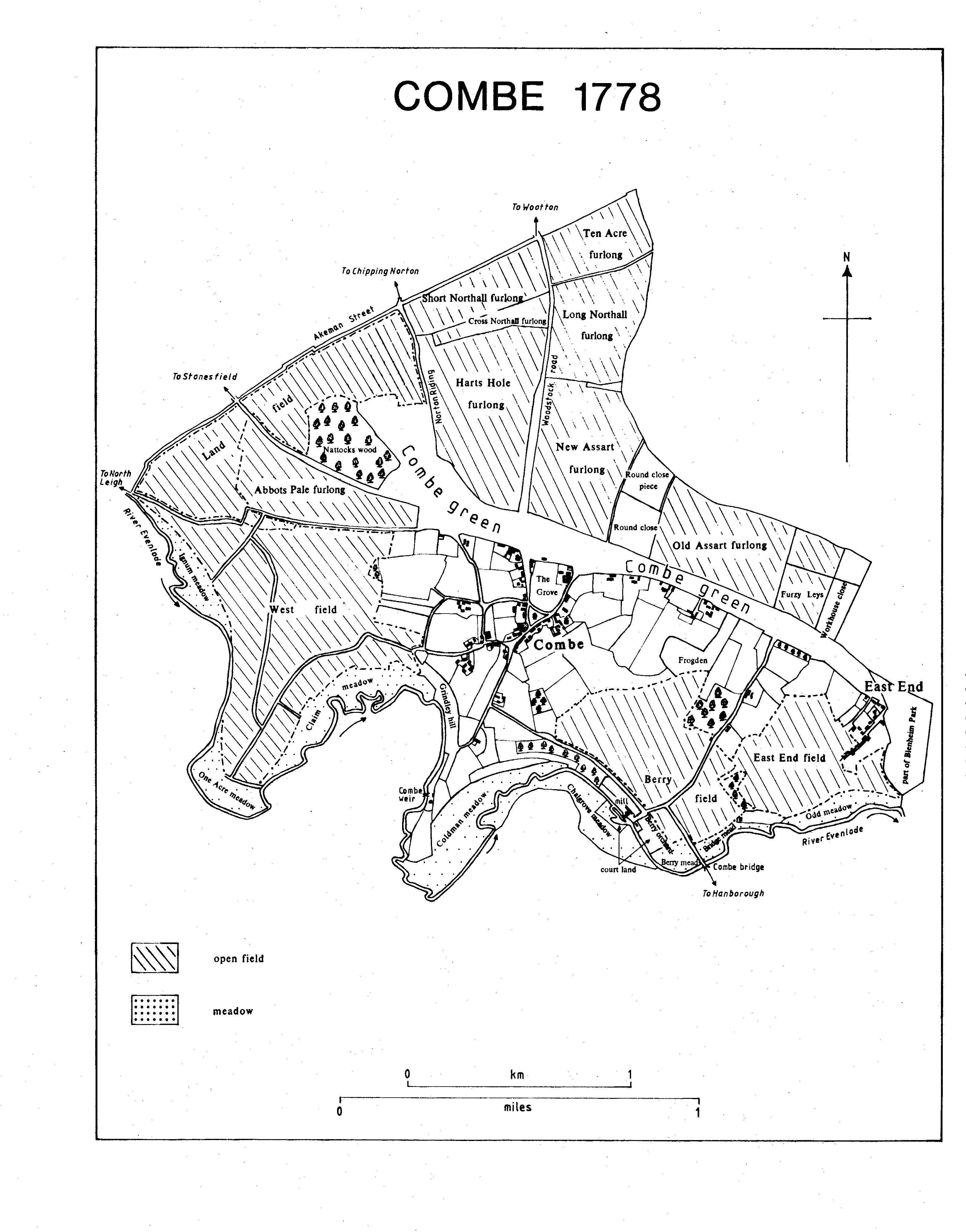
Combe lies on the north bank of the river Evenlode 3 miles (c. 5 km.) west of Woodstock, and includes, besides Combe village, the small hamlet of East End. (fn. 70) The parish is of compact shape, bounded on the north by the line of the Roman Akeman Street, on the east by Blenheim Park, and on the south and west by meanders of the Evenlode save for a short stretch where the boundary lies south of the river, perhaps following the line of a meander abandoned naturally or diverted to serve Combe mill. The boundary with the park was altered in the 1660s by the imparkment of c. 35 a. at East End known as Combe, or Broad, leys. By 1778 an area of 17 a. east of the houses at East End had been taken into the park, and shortly afterwards four closes and part of Old Assarts furlong, comprising in all 38 a. west of the former Combe leys, were annexed to form New Park. (fn. 71) The 18th-century encroachments were still considered to belong to Combe parish in 1818 and possibly as late as the mid 19th century, (fn. 72) but were later treated as part of Blenheim parish. (fn. 73) The total area of the parish since those reductions is 1,417 a. (573 ha.). (fn. 74)
At the centre of the parish a broad band of Oxford and Kellaway clay forms a plateau that shelves from c. 120 m. at Notoaks wood to c. 100 m. at East End, an area roughly coextensive with the former great green, a broad swathe that ran east-west across the parish, and with settlement and its adjacent pasture closes stretching from Combe village along the green to East End. Towards the western and the clay is overlain by glacial sand and gravel upon part of which on the northern outskirts of the village modern housing has been built. Surrounding the clay, and providing the principal arable land, are successive bands of cornbrash, forest marble, and limestone of the Great Oolite that covers much of the northern part of the parish. The limestone and forest marble have in the past been quarried for use locally. Near Combe mill and Combe railway halt there are deposits of river gravel. The alluvium lining the Evenlode has provided extensive meadowland. Beyond the clay north of the village the ground dips to c. 100 m. south of Akeman Street Farm before rising gently to c. 115 m. at the parish boundary. West of the village there is a more abrupt junction with the forest marble and stonebrash, in the form of a gulley running along the eastern edge of West field, before inclosure one of the parish's larger open fields. South of the village the ground declines to c. 100 m. at the head of Grintley hill and Combe cliff before plunging to the valley floor 30 m. below. There are similarly steep slopes at the western edge of the parish, but elsewhere the fall is more gradual. (fn. 75)
Combe 1778
Combe was recorded in the later 13th century as lying within the royal forest of Wychwood; (fn. 76) it was alleged in 1337 to have been afforested by Henry III. (fn. 77) Much of the northern part of the parish seems to have been woodland as late as the 13th century, and the forest for long played an important role in the lives of Combe people: they had the right to pasture animals there, (fn. 78) but seem in the Middle Ages, and possibly later, also to have been indefatigable poachers and foragers. (fn. 79) Damage to crops by animals escaped from Woodstock, later Blenheim, Park was a threat acknowledged by the Crown and by dukes of Marlborough: Henry III used the threat in 1231 to encourage local people to maintain the park walls, (fn. 80) and until c. 1775 it was customary for Combe farmers to be compensated for damage by gifts of venison. (fn. 81) In the 19th century depredations by rabbits seem to have been more serious. (fn. 82)
Akeman Street continued in use along the northern edge of the parish, although diverted round Blenheim Park, until the inclosure of Stonesfield in 1804 and the laying out of a new road north of the old. (fn. 83) Combe otherwise lay off major through roads, north-south travel obstructed by the river and its steep approaches on both sides, east-west travel by the park. The road from Witney to Bicester, the principal route for wheeled traffic, was picked up at Hanborough. The preferred route to Oxford for horse and foot traffic lay along Frogwelldown Lane, which began east of Hanborough bridge and ran through Bladon, Cassington, and Yarnton. Alternatively, it was possible to traverse the south-west corner of the park, cross the Glyme, and follow the road that ran south of Bladon church to Begbroke. (fn. 84) Access to the park, and so to Bladon and Woodstock, was by gates and stiles, among which may be mentioned Stonesfield steps, towards the north-east corner of Combe parish; Combe door, south-west of Park Farm; Combe gate, the name given to a number of gates between Combe door and East End from the 16th century, and eventually appropriated to the entrance at Combe lodge. (fn. 85) Several roads radiate from the village. Akeman Street, described in 1673 as 'via regia', (fn. 86) runs due north to meet its Roman namesake. The road to Stonesfield passes south of Notoaks wood, and in the 18th century a branch ran north of West field to Stonesfield ford. It was probably suppressed at Combe's inclosure in 1792. (fn. 87) The road south to Grintley hill and to Combe weir, perhaps the weir mentioned in 1302, (fn. 88) may be that known in 1579 as London's Lane after the family of that name prominent in Combe from the Middle Ages and holders of a tenement in the lane. (fn. 89) A road ran south-east from the lane along Combe cliff to the mill and Combe bridge, but a more direct paved footpath from the village began west of the rectory and ran downhill along the eastern edge of Peagle wood. The path was described as ancient in 1742, at about which time it seems to have been suppressed. (fn. 90) East End was reached by way of the green; a footpath set out along it soon after 1777 was rebuilt as Park Road, apparently in the late 19th century. (fn. 91) Bolton's Lane was mentioned in 1606, named after the family which also gave its name to Bolton's Farm, which it occupied into the 19th century. (fn. 92) The lane ran down to Combe mill, and there was a branch to Combe bridge until at the construction of the railway the south end of the lane was rerouted directly to the bridge. At the same time the road from London's Lane to the mill was altered to pass north of the line. Access to the mill thereafter lay south of the railway bridge. (fn. 93)
Combe bridge existed by 1258 when Henry III granted three oaks towards its repair. (fn. 94) It or a successor was rebuilt in 1772 as a plank bridge with a single stone pier. It was destroyed by floods in 1822-3, and although the parish had been responsible for it, it was rebuilt at the county's expense in 1825, as a stone bridge with two arches over the river flanked by a land arch at each end. (fn. 95) In the 18th century footbridges, probably ancient in origin, crossed the river at the mill and at Combe weir; a third, between them, is modern. (fn. 96)
Work on the Oxford, Worcester, and Wolverhampton Railway line through Combe began in 1847, and the line was opened in 1853. The engineering at Combe was difficult, requiring deep cuttings, most notably that spanned by Grintleyhill bridge, four crossings of the Even lode, and the diversion of a stretch of the river west of the mill. (fn. 97) A siding was run into the mill and a private level crossing gave access to the mill from the road beyond the line. The siding was taken up in 1953. (fn. 98) Combe halt, usually said to have opened in 1937, (fn. 99) was recorded from 1935. (fn. 1) It remained open in 1988.
A weekly service by carrier to Oxford and Witney was in operation by the mid 19th century, (fn. 2) and in the later 19th century a carrying business was run from Combe by the Phipps family. (fn. 3) In the 1930s Harry Knibbs was a local celebrity as 'one of the very last of the old-style carriers'. (fn. 4)
A solitary flint blade was found south-east of the railway bridge over Bolton's Lane; pottery discovered between Foxhole Barn and Lower Westfield Farm may be neolithic or may be associated with the Bronze Age gold-plated ring money that was found nearby. Romano-British finds have been fairly common, as might be expected so close to Akeman Street and to villa sites at North Leigh and Stonesfield. The remains of terracing below Lower Westfield Farm facing the great villa at North Leigh may have been used for vine growing. (fn. 5)
In 1086 Combe was a small place with a recorded population of only 12 unfree tenants and 2 servi. (fn. 6) By 1279, when 40 tenants were named, population was apparently outstripping resources, (fn. 7) but by 1377, when only 87 adults were recorded, there had been a decline. (fn. 8) The numbers of taxpayers (30) in 1524 and of communicants (72) in 1548 (fn. 9) do not suggest an increase, but the population may have grown from the later 16th century, for c. 50 households were recorded in the early 17th, five of them at East End. (fn. 10) In 1642 the Protestation Oath was taken by 176 men and women, 171 adults were reported in 1676, and 52 households were recorded in 1662. (fn. 11) Combe was then as populous as its neighbours Hanborough and Wootton, but from the later 17th century it seems to have fallen behind. The number of baptisms remained at 8 or 9 a year until the mid 18th century. There was heavy mortality in the 1670s and 1680s, and during the smallpox epidemics of the 1720s, burials outnumbered baptisms. Population seems to have grown rather more rapidly in the later 18th century, perhaps encouraged by the expanding Woodstock gloving industry. There were periods of high infant mortality: in 1779-81 half those buried were infants, and 16 of the 19 people buried in 1815 were children. (fn. 12) There were 424 people in the parish in 1801, and the total rose steadily to a peak of 655 in 1851 when the population was temporarily inflated by railway workers. Relatively the greatest increase was at East End, where in 1841 there were 18 households and c. 90 people. (fn. 13) There were 627 people in the parish in 1861, after which there was an uninterrupted decline to 408 in 1931. The decrease in 1871 was attributed to migration, and there were commonly between 7 and 12 houses uninhabited in the later 19th century and earlier 20th. (fn. 14) After the Second World War there was an influx of commuters, notably in the 1960s when the number of households increased from 167 to 220. In 1981 there were 660 residents. (fn. 15)
The inappropriateness of the name Combe, meaning a valley, (fn. 16) for a hill-top village 45 m. above the valley floor has usually been explained by a shift of settlement away from an earlier site by Combe mill. The antiquarian White Kennett visited the site in the late 17th century and reported seeing the foundations of a perimeter wall and of a building which he supposed to be a church. (fn. 17) The site lies just above the river bank c. 100 m. south-east of the mill, on a knoll covered with fragments of worked stone beyond which, on the north-east and south-east, is the outline of a boundary wall. Ploughing has destroyed any plan, but it has uncovered ridge tiles, stone slates, part of a 13th-century tomb cover, and medieval mouldings of uncertain date. Large quantities of stone have been tipped down the river bank and await systematic examination. (fn. 18) Pottery from the site is domestic ware, mainly 11th-13th century with a few pieces of the 14th and 15th centuries. (fn. 19) The remains, lying in Bury, or Berry, orchard, described in the 18th century as court land, (fn. 20) might include those of a manor house, and the presence of the tomb cover may link with documentary evidence of two churches in Combe as late as the 16th century. (fn. 21) Three rectangular ponds shown south-east of the site in 1880 are not shown on maps of 1778 and 1806. (fn. 22) There is no sign of settlement north, east, or south of the knoll, where the ground is apt to flood, and any houses are likely to have lain to the west and to be buried beneath the greatly enlarged mill site. The position, south-facing and in the lee of a hill, is attractive but the adjoining watermeadows would restrict expansion, and a move by some up the hill probably began early, to be recorded in such 13th-century family names as de la hill and de la green. (fn. 23) It is claimed that pottery of c. 1200 has been found in Combe village, (fn. 24) and, if a nave doorway of c. 1200 dates the parish church, (fn. 25) the hill-top site was already important. In the 1260s the Crown sanctioned the inclosure of 10-12 pieces of demesne land, possibly as house plots, (fn. 26) a development perhaps recalled in 1336-7 when several people, seeking to prove that Combe was royal demesne, asserted that Henry III had taken Combe into the royal forest of Wychwood and had granted tenants land on which to build, the new vill adopting the same name as the diminished early settlement. Their account may have simplified and compressed a longer and more complex process. A counter-claim that the Combe of 1336 was the same as that in Domesday Book was probably concerned more with status than with physical location, although the claimant once described Combe as being by Hanborough, not, as was usual, by Woodstock. (fn. 27) Extensive further encroachments in the late 13th century and early 14th suggest the establishment of plots and closes within the new village. Combe was not, therefore, as has been suggested, a planned resettlement following the Black Death, (fn. 28) although plague could have led to consolidation at the upper site.
The church's position at the edge of the village may indicate that it was one of the last sites to be built on, (fn. 29) though it is as likely to have been chosen because it is on a slight eminence and relatively well drained. To the north-west is Alma Grove, a house and walled close of c. 8 a. around which village streets have been deflected and which may have been the site of a new manor house. (fn. 30) At the southern end of Alma Grove is the triangular village green, which seems always to have been distinct from the great axial green across the centre of the parish. An irregular scatter of houses faces the grove and the village green, giving the village an expansive air not offset by dense concentrations of houses on the south and north-west. The layout of the village remains largely that depicted in 1778, (fn. 31) with Alma Grove at the eastern edge of a composite village. (fn. 32) The network of streets west of the grove formerly extended further westwards, apparently serving farmsteads such as the Old Farm House and West Close Farm, which are known to have been in existence by the late Middle Ages (fn. 33) and which lay convenient to the open fields in the north and west. In the same period Butcher House, the later Foxhole Farm, Belson's, the manor house, Whitton's, and probably others ranged dispersedly along the south side of the great green from Chatterpie Lane towards Bolton's Lane, (fn. 34) on sites presumably first occupied to take advantage of newly cleared land north of the green. The strung-out shape of settlement from Horne's Close south of the village, through the village and along the great green, perhaps as far as East End, may have been what by the mid 14th century earned Combe the epithet 'Long'. (fn. 35) If so, there was considerable rebuilding in Combe in the late Middle Ages, perhaps in some cases encouraged by the sale of Crown land. (fn. 36) The survival of several houses of that period, modified and adapted rather than rebuilt, reflects the subsequent lack of wealth in the parish. The greatest change within the village has been encroachment and infilling. In 1529 the rectory orchard extended to the village green, (fn. 37) but by the later 18th century cottages had been interposed, and the green was further reduced on the south in the 19th century by the building of houses in front of those in Church Walk, which as a result became an alleyway. Narrow plots running back from Church Walk have from the 18th century been crammed with cottages. Open ground south-west of the green was reduced in the 19th century by the building of the United Methodist Free chapel (1861, enlarged 1882) and a row of cottages. Other prominent 19th-century additions to the village included the Wesleyan chapel (1835, rebuilt 1893-4), the school (1843, enlarged 1893), the reading room and coffee-house (1890, designed by H. W. Moore), and the new vicarage (1892). (fn. 38)
The road along the west side of Alma Grove has been narrowed by the grove's enlargement, probably in the late 18th century, and by householders' encroachments. (fn. 39) The principal change in the 20th century has been an increase in the number of houses, from c. 110 in 1931 to c. 210 in 1981. (fn. 40) Much of the development has been in and around the angle of Akeman Street and Stonesfield Road, starting with a few council houses c. 1927 but expanding more rapidly after 1945 with a mixture of houses, bungalows, and Blenheim estate cottages. The west and of Park Road was built over in the late 1950s and early 1960s, and there has since been infilling opposite. A small housing estate known as the Orchard was built in the 1960s behind older houses west of the village green, and south of the Orchard in the 1980s a walled-off group of five large houses with shared tennis court and swimming-pool was constructed. (fn. 41)
The hamlet of East End comprises c. 12 houses in an isolated position on the eastern edge of the parish adjoining Blenheim Park, and possibly originated as a squatter settlement. In the early 17th century some ½-yardland and cotland tenements were based on homesteads in East End, and were presumably medieval in origin. (fn. 42) The number of houses there grew from c. 12 in 1778 to 18 in 1841, but contraction followed, and c. 1914 two houses and three cottages at the southern end of the hamlet were demolished. (fn. 43) In the 17th century and possibly earlier there seem to have been isolated houses in Bolton's Lane and at Combe weir where the surviving house is dated 1732. (fn. 44) In 1778 there was also a house between the weir and Horne's Close, and another in Bridge meadow; the former had gone by 1806, (fn. 45) and the latter was perhaps demolished at the building of the railway line. At about the time of inclosure in 1792 Akeman Street Farm and Lower Westfield Farm were built in the former open fields. (fn. 46) The mill was rebuilt in Scottish baronial style in the mid 19th century. Manor Farm was rebuilt as a substantial house, possibly also in the mid 19th century.
Combe's older houses are mostly built of limestone rubble, with stone slate or clay tile roofs; thatch, formerly commonplace, has become unusual. Modest farmhouses and small cottages predominate and reflect Combe's history as a community of small and middling farmers and of labourers, its living from agriculture supplemented by cottage industry, quarrying, and timber-sawing. Foxhole Farm is unusual in incorporating fragments of a timberframed building and in having been rebuilt in the early 18th century as a gentry house. (fn. 47) West Close Farm retains elements of a late medieval plan, including the doorways of a screens passage, and a re-used cruck with joints suggesting a 16th-century origin. The house was sold by the Blenheim estate in 1988.
The Old Farm House, at the south end of Chatterpie Lane, retains in its west range a medieval plan with a high central room with blocked opposed doorways and a large side stack. The cross-wing at the east end has a 16thcentury roof. The short back wing at the west end was probably added in the 17th century, that at the east end and the low additions between were built in 1922 when the house was remodelled for Sir Hamo Thornycroft, the sculptor. Green Close, south-west of the village green, incorporates in its main range the greater part of a small late medieval house whose hall has a raised cruck truss. In the 17th century it was floored over and a chimney stack was inserted into its east end beyond which a threebayed continuation of the range was built. A short back range was added to the west end of the main range in the 18th century, and in the earlier 20th century extensive service quarters were added by Mrs. Ursula Cottrell-Dormer in the angle between the older ranges.
Whitton's, 300 m. east of Alma Grove, is a thatched house of late medieval origin and retains a hall of one bay formerly open to the upper-cruck roof, a second bay to the west having a room above it reached by a stone newel stair from the hall; at the east end there was a short service bay. The open bay of the hall was floored over in the 17th century when a stack was inserted between it and the former cross passage. By 1952 the house had been restored, (fn. 48) and additions have since been made to both ends.
Horne's Close, south of the village in the angle created by the sharp turn of the Hanborough road, is also of late medieval origin, extensively remodelled in the 18th century. Higher Westfield Farm has an irregular plan, probably of the earlier 17th century. It was refitted in the later 18th century and remodelled in 1984. (fn. 49) Chatterpie House, formerly West End Villa, incorporates part of a 17th-century house rebuilt or extended eastwards in the 19th century and given a north wing c. 1905 when the house was remodelled for William Stowell. The exterior was cement rendered and decorated in a style reminiscent of Russia, where Stowell had lived. (fn. 50) The building or rebuilding of farmhouses and cottages in the 18th century continued to be in traditional local materials, but in the 19th brick came into use, notably at the parish reading room and at the vicarage, both built from bricks produced at the Bolton's Lane brickworks. (fn. 51)
Combe was dismissed c. 1800 as a 'small, dirty village', (fn. 52) but Mark Pattison in 1843 described it as a very pretty village, thoroughly rural in character, without any attempt at the 'genteel cottage' which disfigured most country places. (fn. 53) In the later 20th century efforts to preserve Combe's reputation as 'one of the prettiest of Oxfordshire villages', (fn. 54) combined with its demise as a working village, have given it something of the air of gentility disliked by Pattison. Since the 1950s the Blenheim estate has controlled the design of houses built on plots bought from it, and bungalows and chalets have predominated. The group of expensive houses south of the Orchard has aroused fierce controversy. (fn. 55) Development generally, however, has respected the ancient pattern of dispersed settlement within the village. Alma Grove and the village green were transformed by the removal of an ancient oak tree in 1956 and by the effect of elm disease in the 1970s. (fn. 56) Extensive replanting has been undertaken.
Water was normally supplied from wells, and there was a public well on the green in 1832 when a child drowned in it. (fn. 57) The parish pump stands disused between the former vicarage and Church Cottage. Mains water was installed in 1934-5 and electricity in 1931. Following prolonged complaints about drainage a mains system was installed in 1968 and a sewage works was built between Higher and Lower Westfield Farms. (fn. 58)
In 1701 there were 10 licensed alehouses in Combe, (fn. 59) but by mid century there were only three, and from 1774 only the Cock inn, which stood then north-east of the church. It was demolished in 1828 and replaced by Church Cottage, the name being transferred to a house west of Alma Grove, where it remains. (fn. 60) There seems c. 1820 to have been a second, probably short-lived, public house, the Dog and Whistle. (fn. 61) The Blandford Arms, south-west of the village green, was trading by 1841, and the Royal Oak, south of the green, was recorded in 1847, (fn. 62) being rebuilt in 1858. (fn. 63) By 1854 a fourth house, the Marlborough Arms, was in front of the village school. (fn. 64) The Blandford Arms ceased trading by 1929, (fn. 65) the Marlborough Arms in 1965, and the Royal Oak in 1966. (fn. 66)
A miraculous raising from the dead by St. Augustine of Canterbury was set by a 15th-century hagiographer in 'Woodstock Cometona' near Oxford, thought possibly to be Combe. (fn. 67) A visit by Henry I more credibly can be inferred from the dating of a grant at Combe c. 1132. (fn. 68) Henry VIII visited the parish in 1536. (fn. 69) The proximity of Woodstock Palace attracted royal clerks, ministers, and courtiers to live, usually briefly, at Combe, perhaps the best known being Sir Thomas Elyot. (fn. 70a) Lincoln College, appropriator of the church, hired a house in the village in 1527 during an epidemic in Oxford. (fn. 71a) Of longestablished families the Woodwards and Huckinses were at Combe by the late 16th century, the Busbys, Colliers, and Slatters by the later 17th. (fn. 72a)
On 13 April 1692 a fire burned down the houses and barns of eight people, destroying 86 bays of building. (fn. 73a) In 1778 excitement was aroused by the trial and execution of the parishioner Robert Hitchcock for patricide. (fn. 74a) The so-called Combe riot of 29 September 1822, ostensibly provoked by the efforts of Edward Tatham, rector of Lincoln College, to eject Bartley Lee from the chaplaincy, seems in reality to have been more complex in origin: the opposing factions wore political colours, and there are indications that the parish's leading farmers opposed Lee because of his support for what they considered excessive rating demands. Lee's support lay principally among the smaller farmers and labourers. (fn. 75a) The dispute and its aftermath poisoned relationships for many years and encouraged dissent. Combe was known for factiousness into the late 19th century, (fn. 76a) when it had a reputation as a 'benighted little place' and as a 'bye-word and a scoffing to all the villagers around', but also for stubborn independence, particularly in relation to the church and to Blenheim Palace. (fn. 77a)
The parish wake was in the early 18th century kept on the last Sunday in August. (fn. 78a) Known as Combe Feast, it was later held on the Sunday, Monday, and Tuesday following St. Laurence's day (10th August). In the later 20th century it took the form of a religious service, reintroduced after being abandoned early in the century, and a fun-fair on the village green. (fn. 79a) Maypole dancing by schoolchildren on the village green takes place annually. Combe Friendly Society was founded in 1780 (fn. 80a) and in 1813 had 99 members. (fn. 81a) There was a Blandford Arms Friendly Society in 1853 (fn. 82a) and a clothing club in 1878, (fn. 83a) but no other reference has been found. The Combe Temperance Reading Room and CoffeeHouse, built in 1890 and formally opened in 1892 through the efforts of Miss Adela Brooke, who had run a small library from the rectory house, met initial resistance but within a year had 120 members, exclusively men for the first few years. (fn. 84a) During the Second World War an Entertainments National Service Association (ENSA) troupe was based at the rectory. (fn. 85a)
Combe is renowned for its devotion to sport, notably cricket, which is a strong cohesive force in the village. In 1947 a field north-east of the church was bought as a recreation ground which was inaugurated in 1949 by the duke of Edinburgh. (fn. 86a)
In the earlier 19th century the house by Combe weir was used as an isolation hospital during epidemics. The parish stocks, north of the old oak tree on the village green in 1828, had gone by the late 19th century. (fn. 87a) The parish pound, towards the west end of the village, was maintained in the 20th century by the parish council. In the 18th century there was a large village pond south-west of the green. (fn. 88a) It was reduced in size by encroachment in the 19th century and apparently became a shallow pool liable to dry out. It survived in the earlier 20th century, but was later drained. (fn. 89a)
Topographical collections relating to Combe were compiled by Charles Richardson (d. 1827), (fn. 90a) alderman of London, formerly of Combe, and by Stephen Pearce, vicar 1892-1922. (fn. 91a)