A History of the County of Cambridge and the Isle of Ely: Volume 10, Cheveley, Flendish, Staine and Staploe Hundreds (North-Eastern Cambridgeshire). Originally published by Victoria County History, London, 2002.
This free content was digitised by double rekeying. All rights reserved.
A F Wareham, A P M Wright, 'Kennett', in A History of the County of Cambridge and the Isle of Ely: Volume 10, Cheveley, Flendish, Staine and Staploe Hundreds (North-Eastern Cambridgeshire)(London, 2002), British History Online https://www.british-history.ac.uk/vch/cambs/vol10/pp458-461 [accessed 30 April 2025].
A F Wareham, A P M Wright, 'Kennett', in A History of the County of Cambridge and the Isle of Ely: Volume 10, Cheveley, Flendish, Staine and Staploe Hundreds (North-Eastern Cambridgeshire)(London, 2002), British History Online, accessed April 30, 2025, https://www.british-history.ac.uk/vch/cambs/vol10/pp458-461.
A F Wareham, A P M Wright. "Kennett". A History of the County of Cambridge and the Isle of Ely: Volume 10, Cheveley, Flendish, Staine and Staploe Hundreds (North-Eastern Cambridgeshire). (London, 2002), British History Online. Web. 30 April 2025. https://www.british-history.ac.uk/vch/cambs/vol10/pp458-461.
KENNETT
The parish of Kennett, c. 4 km. (2½ miles) north-east of Newmarket (Suff.) and c. 8 km. (4 miles) north-west of Bury St. Edmunds (Suff.), covering 560 ha. (1,431 a.), lies in a projection of the county that stretches eastwards into Suffolk. (fn. 1) The name Kennett is of Celtic origin, and has been associated with kun-, or cwm-, top or summit. (fn. 2) Early spellings vary, but from c. 1604 Kennett has been the commonest. (fn. 3) The modern southern settlement is called Kennet End.
The northern, southern, and western parish boundaries are at right angles to each other. The irregular course of the river Kennett forms the southern end of the parish's eastern boundary before running northwards through its northeastern section. There are alluvium and river terrace deposits on the river's north-east and south-west banks, and glacial silt and gravels, eventually worked-out, underlie its central loop. A ford crossed the Kennett c. 1161, and in the late 13th century a ferry crossing was known as Kentfayre. (fn. 4) The river was navigable at least until the early 14th century, connecting the parish to the fenland waterways, and on to King's Lynn (Norf.). (fn. 5) Occasional overflows from the river caused serious damage to property in the eastern section of the parish, destroying the railway bridge in 1968, but in 1977 a pumping station was built at the northern end of the central loop to control the water flow. In 1995 the river had ceased to flow. A tributary of the river Snail rises 600 m. east of the middle of the western parish boundary, and then flows northwards. In the centre of the parish there is an elevated plateau (30 m. high), with Dane hill at its north-western tip. The ground then falls away to the north and south before rising at the southern edge of the parish to 30 m. The topsoil of chalk, clay, and gravel overlies Lower Chalk, which runs from north-west to south-east. In the 1790s gravel beds yielded high quality marl. (fn. 6)
A bridge stood at the south-east corner of the parish from 1604 or earlier, linking Kennet End and Kentford (Suff.), and was known as the old bridge in 1797. (fn. 7) It was crossed by the main Newmarket-Bury St. Edmunds road. That was a major route during the 17th century, and a turnpike during the late 18th and 19th centuries. (fn. 8) In the mid 12th century the road which ran north-eastwards through the north-west corner of the parish, along the route of the ancient Brandon way, was known as the Freckenham road, but since c. 1797 as the Norwich road. (fn. 9) Tree-lined since 1820, it was widened in 1929. (fn. 10) It was crossed by the Chippenham Road, recorded in 1161. (fn. 11) In the early 19th century, and probably before, the Chippenham Road divided into two roads, running eastwards towards the village. (fn. 12) The northern route ran over the heathland, but was closed off at inclosure in 1823. The southern road, on the boundary between the heath and South field, met other roads, running north-eastwards to Herringswell (Suff.), and southwards to Moulton (Suff.), at a triangular junction south of the village. From c. 1820 the Moulton road was named Kennet End road, and from c. 1854 Station Road. (fn. 13)
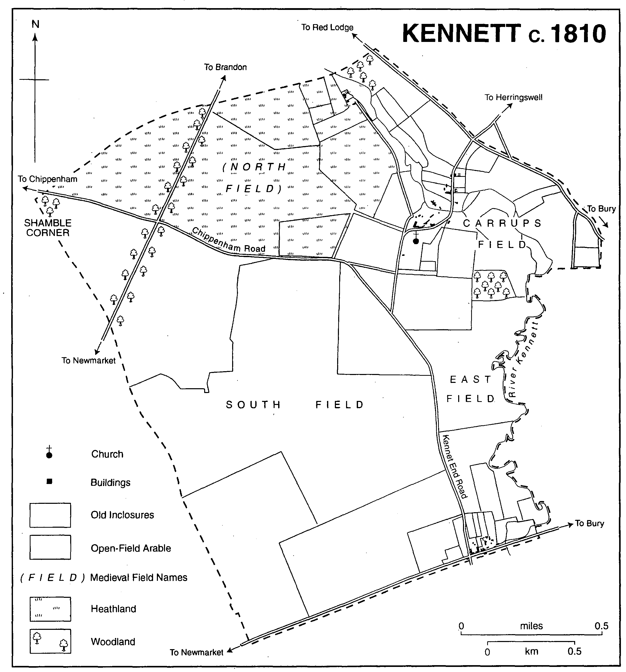
Kennett c.1810
The Newmarket to Bury St. Edmunds railway line, existing in 1854, runs south-eastwards in a cutting through the south of the parish; Kennett railway station was built midway between Kennett village and Kennet End on Station Road. (fn. 14) The station also served neighbouring parishes during the 19th and 20th centuries, with a staff of four including a station master between c. 1861 and 1891. (fn. 15) From 1965 it was closed to goods traffic, and after 1967 it became an unstaffed halt on the Cambridge-Ipswich line. (fn. 16) The Newmarket bypass, built c. 1972-5, runs parallel with the railway line, the two separating the northern part of the parish from Kennet End. (fn. 17) Between 1989 and 1998 there was only one bus service daily from Kennett village, but there were better bus services from neighbouring Kentford (Suff.). (fn. 18) One in five households in Kennett had no car in 1991, double the proportion in neighbouring parishes. (fn. 19)
In 1086 Kennett was inhabited by 19 peasants. (fn. 20) By 1279 it included 30 landholders; in 1327 there were 27 tax-payers at Kennett and Badlingham; and in 1377 the poll tax was paid by 48 adults in Kennett and Kentford. (fn. 21) There were 17 dwellings in 1664 in Kennett and Badlingham. (fn. 22) Kennett's inhabitants numbered 90 in the early 1790s, 111 in 1801, 164 in 1821, and 208 in 1851. (fn. 23) During the 1850s and 1860s the population declined, but c. 1871-81 was stable at c. 159-65. It had increased to 182 in 1911, and remained at 200 between 1931 and 1951, and from 1961 to 1991 at c. 270.
During the Middle Ages Kennett village developed to the north of the parish church along the Herringswell Road, across the valley of the river Kennett, sheltered by the north-east face of the central plateau. Between 1664 and 1674, apart from the manor house and a farmhouse, probably at Dane hill, no dwellings had more than five hearths, and a third of them had either one or two. (fn. 24) There were 15 houses in the parish in the early 1790s. (fn. 25) In 1821 houses stood at the corner of the Chippenham and Kennet End roads south-east of the triangular junction, and in 1841 there were 25 households at Kennett village. (fn. 26) In 1849 a new bridge, with abutments and wing walls and an iron-girder superstructure, was completed over the river in the heart of the village. (fn. 27) Between 1865 and 1873 the southern section of the village street was diverted eastwards, slightly further away from the church, on the orders of the principal landowner. (fn. 28) A council housing estate was built c. 1958-62 in the triangular junction to the south of the village. (fn. 29) In the mid 1980s those houses were purchased by tenants, or taken over by the Hereward Housing Association. (fn. 30) In 1989 there were 48 houses in the triangle, which formed the new centre of the village, another ten houses standing along the village street and Church Lane. (fn. 31) The barn of Hall farmhouse at the northern end of the village street was converted in 1986 into a large and opulent house. Ten new detached houses were built in 1997-8 at the north-east corner of the triangle.
From the late 16th century there has been a farmhouse at Dane hill, 0.5 km. west of the village, on the south-side of the Chippenham Road. It is a timber-framed L-plan building with an attic and a plain tiled roof, and may have had six hearths in 1664 and 1666. (fn. 32) An adjoining 17th-century one-storeyed cottage-gatehouse with an attic was also occupied in 1998. (fn. 33) During the 19th century there were six cottages nearby, but in 1903 only three. In the late 20th century the cottages were modernized, and the farmhouse was split into two dwellings.
In 1797 at Kennet End there were houses at Market row along the northern side of the Bury St. Edmunds-Newmarket turnpike. (fn. 34) In 1823 there were 14 dwellings, which each had c. 1 a., held as freehold, stretching back from the Bury turnpike. (fn. 35) There was further development northwards along Station Road, with seven pairs of cottages c. 1861, and a further 20 by 1925. (fn. 36) Kennet End was significantly larger than Kennett village during the late 19th and early 20th centuries, and in 1997 there were c. 40 houses there. In 1990 after much effective campaigning by Kennett's inhabitants the county council rejected plans for an additional 1,500 houses in the parish. (fn. 37) In 1991 there were 130 dwellings, comprising 55 detached houses, 55 semi-detached houses, and 10 other types of dwelling. (fn. 38)
The Bell Inn on the crossroads at Kennet End dates from the 16th century. In 1737 Edmund Bowle of Pakenham (Suff.) sold the public house and 21 a. of land to Thomas Evans, and in 1785 it provided a change of horses for travellers. (fn. 39) It remained in the hands of members of the Skulthorpe family from 1783 to 1854, and from 1818 until the late 1990s it provided accommodation for travellers. (fn. 40) During the 20th century Kennett's inhabitants relied for some social activities upon Kentford, belonging to its Women's Institute or British Legion branches. (fn. 41) In 1951 Donald McClaren gave 2 a. east of Station Road to Kentford and Kennett sports club for use as playing fields. (fn. 42) In 1997-8 there was an unresolved debate over whether to build a new village hall on that site, or in Kentford.
The heathland in the north-western corner of the parish was quarried extensively during the early 20th century, and was then used as a waste tip by local racing stables. From the early 1980s scramble-bikers rode there, but in 1991 the 60-a. site was purchased by Wildtracks Ltd. (fn. 43) The company offered a range of off-road activities, and was said to own the largest collection of privately owned military vehicles in the country. (fn. 44) In the late 1970s Suffolk county council deposited 250,000 tonnes of waste in the adjacent area east of the Norwich road. In 1996-8 the council wished to use the site to pile up a waste disposal mound, 38 m. high, occupying 82 ha. (202 a.), but the plan was opposed by Kennett's inhabitants. (fn. 45)