A History of the County of Chester: Volume 5 Part 1, the City of Chester: General History and Topography. Originally published by Victoria County History, London, 2003.
This free content was digitised by double rekeying. All rights reserved.
'The city of Chester', in A History of the County of Chester: Volume 5 Part 1, the City of Chester: General History and Topography, ed. C P Lewis, A T Thacker (London, 2003), British History Online https://www.british-history.ac.uk/vch/ches/vol5/pt1/pp1-8 [accessed 30 April 2025].
'The city of Chester', in A History of the County of Chester: Volume 5 Part 1, the City of Chester: General History and Topography. Edited by C P Lewis, A T Thacker (London, 2003), British History Online, accessed April 30, 2025, https://www.british-history.ac.uk/vch/ches/vol5/pt1/pp1-8.
"The city of Chester". A History of the County of Chester: Volume 5 Part 1, the City of Chester: General History and Topography. Ed. C P Lewis, A T Thacker (London, 2003), British History Online. Web. 30 April 2025. https://www.british-history.ac.uk/vch/ches/vol5/pt1/pp1-8.
In this section
THE CITY OF CHESTER
This Volume, published in two parts, provides a full treatment of most aspects of Chester's history from Roman times to the year 2000. (fn. 1) The two parts are complementary. The chapters in Part 1 give a general account of the city, covering administrative, political, economic, social, and religious history, divided into six periods: Roman, Early Medieval (400-1230), Later Medieval (1230-1550), Early Modern (1550-1762), Late Georgian and Victorian (1762-1914), and Twentieth-Century (1914-2000). The topographies of Roman and 20th-century Chester form integral parts of the first and last chapters, (fn. 2) while a separate chapter deals with Topography 900-1914. Part 2 of the volume contains detailed accounts of particular topics, institutions, and buildings, grouped in five sections: Local Government and Public Services; Economic Infrastructure and Institutions; The Churches and Other Religious Bodies; Major Buildings; and Leisure and Culture. Part 2 has a full index to the whole volume, including subjects; Part 1 an index only of persons and places mentioned in that part.
Defining chester
Until the 19th century what was meant by 'Chester' was unproblematic. The Roman fortress with its adjacent civilian settlement was succeeded in the early Middle Ages by a small fortified town on the same site. Probably in the 10th century two sides of the Roman walls were abandoned, and by the early 12th century the circuit of walls had reached its modern extent. Sizeable extramural suburbs grew up, including the separately named Handbridge south of the river, which has always been reckoned part of Chester. The suburbs were encircled by Chester's arable fields, meadows, and common pastures, with heaths to the north-east around Hoole, and a large area of marshland to the south-west at Saltney.
Beyond the immediate environs of walled town, suburbs, and farmland, an extensive territory depended upon Chester in the early Middle Ages, covering many townships with their own villages, hamlets, and farms. During the central Middle Ages many of the townships were incorporated into newly formed parishes, leaving a few outliers attached to the oldest Chester parishes of St. Oswald and St. John. They were never strictly speaking part of Chester, and their histories are not treated in this volume.
In the 10th and 11th centuries Chester hundred was one of twelve in Cheshire, but the creation of civic institutions in the 12th and 13th centuries led to the disappearance of the hundred and its replacement by the liberties of the city, the area within which the citizens enjoyed their various individual and corporate privileges. The liberties were first explicitly demarcated by a precise boundary in 1354 but must have existed long previously as a territory whose limits were generally known. They covered some 3,000 acres and included the abbot of Chester's manor north of the city, and an extensive area south of the Dee, focused on Handbridge. Both the manor of Handbridge and its open fields extended beyond the liberties into the township of Claverton to the south. (fn. 3)
On the north-east, north, and north-west the townships immediately beyond the liberties were Great Boughton, Hoole, Newton, Bache, and Blacon. The Hoole boundary was little more than ½ mile from the heart of Chester at the Cross (the central crossroads by St. Peter's church, also the site of the medieval High Cross). The approach to Great Boughton, 1½ miles distant from the Cross, lay through Chester's most important medieval and early modern suburb in Foregate Street and its continuation beyond the Bars, which was called Boughton. Right on the boundary from the early 12th century until the 1640s stood the leper hospital of St. Giles, occupying a tiny extra-parochial area called Spital Boughton. On the south-western side the boundary of the liberties coincided with the national boundary between England and Wales from 1536, when the Act of Union placed the lordship and parish of Hawarden in the newly created Welsh county of Denbighshire (it was transferred to Flintshire in 1541). (fn. 4)
From the 19th century Chester is less easy to define. The liberties circumscribed the formal extent of the city of Chester until minor adjustments were made in 1835, enlarging the municipal borough at the expense of Great Boughton, but already by then the town had spilled over the boundary through residential building in the adjoining parts of Great Boughton and Hoole. The arrival of the railway in the 1840s quickened the growth of Chester beyond the borough boundaries, creating new streets which were physically part of the city but administratively outside the remit of the borough council. North-east of the town, the main railway station was built on the boundary with Hoole, the nearer parts of which were rapidly built over. To the west, the railway brought industrial development and associated housing to a new suburb which straddled the boundary between Chester and the township of Saltney in Flintshire. For a variety of reasons there was no major extension of the city's boundaries until 1936, when the county borough incorporated parts of Great Boughton and Newton and most of Blacon, the last intended for a large new councilhousing estate. Hoole remained a separate unit of local government (latterly an urban district) until it too was absorbed by Chester in 1954. Meanwhile the building of more new housing in the townships of Upton and Bache north of the city created a large builtup area which was not brought under Chester's control until 1974. Even after that date Saltney had to be excluded from Chester district because it was in Wales and the national boundary was regarded by central government as inviolate.
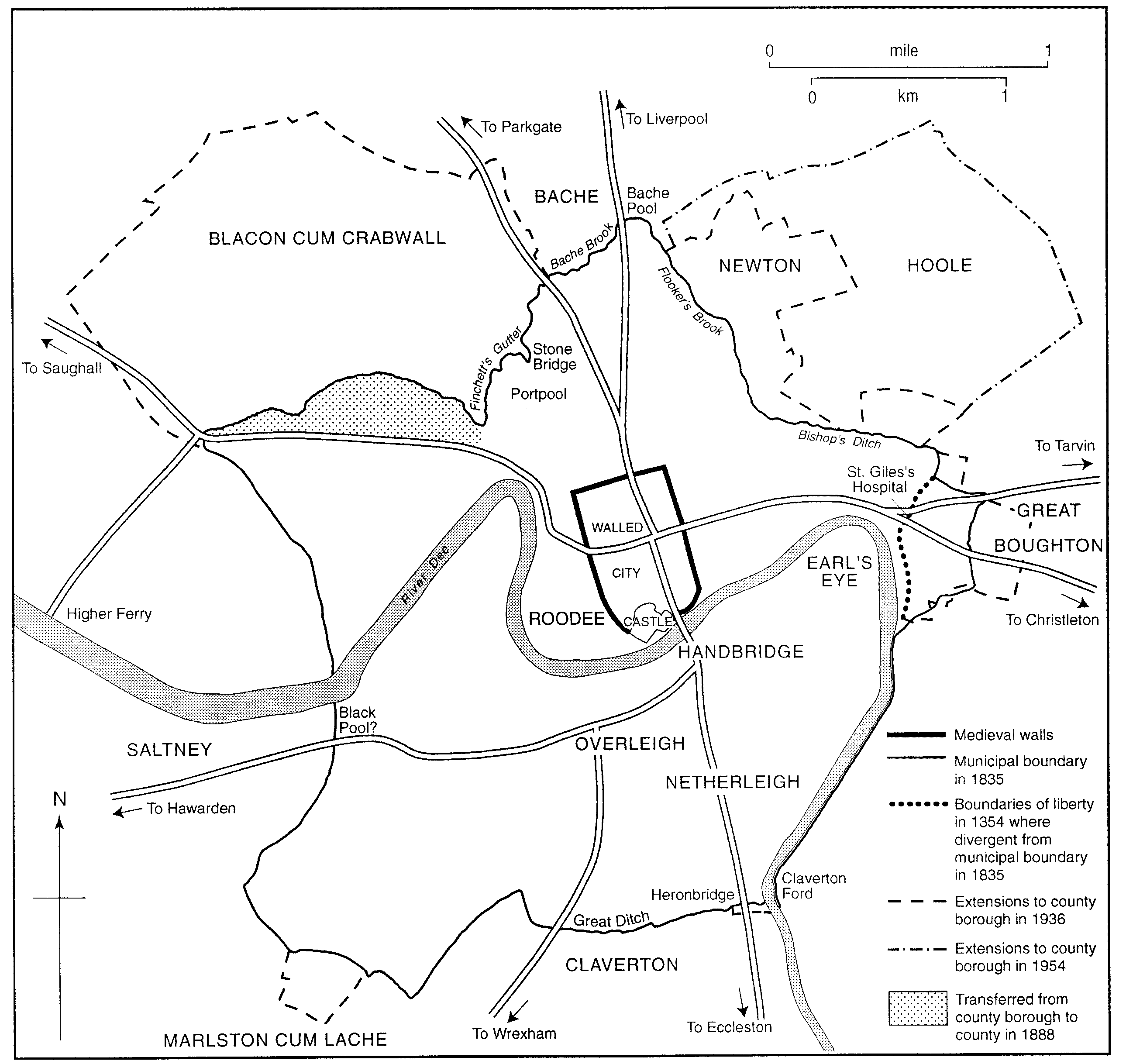
Chester: the city boundaries and neighbouring township
The area described in both parts of this volume is essentially the medieval town and liberties, together with those parts brought within the borough boundary in 1835, 1936, and 1954, but only from the time of their incorporation into Chester. Saltney, Upton, Bache, and Great Boughton are discussed where appropriate, as in the accounts of 19th-century industry and 20th-century suburban housing. The earlier histories of all those townships are reserved for treatment elsewhere.
Name and situation
The Roman name for the fortress built at the head of the Dee estuary was Deva, adopted directly from the British name of the river, and 'Deverdoeu' was still one of two alternative Welsh names for Chester in the late 12th century. Its other and more enduring Welsh name was Caerlleon, literally 'the fortress-city of the legions', a name identical with that of the great Roman fortress at the other end of the Marches at Caerleon (Mon.). The colloquial modern Welsh name is the shortened form, Caer. The early English-speaking settlers used a name which had the same meaning, 'Legacæstir', which was current until the 11th century, when - in a further parallel with Welsh usage - the first element fell out of use and the simplex name Chester emerged. From the 14th century to the 18th the city's prominent position in north-western England meant that it was commonly also known as Westchester. (fn. 5)
Chester's importance as a town has been shaped by its geographical position. The city centre and Handbridge occupy a ridge of sandstone interrupted by the river Dee. The western side of the ridge is a steep escarpment overlooking the Roodee, which until the 12th century was a tidal meadow at the head of a broad estuary extending some 20 miles to the open sea at Hilbre Island and Point of Ayr. The combination of factors made the site both the lowest point at which the river could be bridged (successively, and almost on the same spot, by the Romans and the Anglo-Saxons) and the limit of navigation in the estuary. Navigation and tides in the upper estuary were evidently restricted by a rocky natural feature underlying the man-made causeway or weir constructed just upstream from the Dee Bridge no later than the 1090s. Although little evidence of pre-Roman occupation of the site of Chester had come to light before 2000, local archaeologists then believed that there was likely to have been significant Iron Age activity in the vicinity. (fn. 6)
The geological strata underlying Chester comprise Pebble Beds to the east of Dee Bridge, the Roodee, and Bache, and Lower Mottled Sandstone to the west. Both are overlain by boulder clay except where the ridge protrudes in a line running from Heronbridge in the south through Handbridge and Queen's Park to the walled city. Further north there are pockets of glacial sands and gravels in Newton and Upton, while to the west the former bed of the upper estuary at Sealand, Lache, and the Roodee is composed of alluvium deposited as the river gradually assumed its modern course and width. (fn. 7) The Roman fortress did not occupy the highest point on the ridge, which lies at a little over 30 m. (100 ft.) just north of the city walls. To the north and east the land slopes gently down to about 23 m. (75 ft.) before rising again to a low ridge over 30 m. which runs south-east to north-west through Christleton, Hoole, Newton, and Upton. South and west of the Roman fortress there is a much steeper slope to below 5 m. (15 ft.) on the river bank and the Roodee. South of the river the land rises to about 24 m. (80 ft.) at the southern boundary of the liberties. Within the city walls the natural ground levels have been much altered by almost two thousand years of building and demolition, with the effect of creating a much more level plateau. (fn. 8) The Dee describes a gently winding double bend through the city, flowing first north between Heronbridge and Handbridge on the left bank (within the liberties) and Great Boughton on the right (outside), turning sharply south-west around the meadows known historically as the Earl's Eye, passing in the relatively narrow gap between the walled city and Handbridge, and turning briefly north again around the Roodee. In ancient times the river flowed into the head of the open estuary at the Roodee but since the later Middle Ages it has been directed sharply south-west again for about a mile before finally turning north-west, after the 18th century into the straight canalized stretch which takes it through the reclaimed marshland of Sealand (Flints.) to the open part of the estuary below Flint.
Chester's Importance and ranking
Chester was for many centuries the most important place by far in north-western England. That was largely due to its location at the crossroads of the British Isles, where routes from southern Britain led into north Wales and the Irish Sea. On three occasions its role as the point of entry into the Irish Sea region for rulers based in the South made it prominent in national affairs. At the outset the Romans probably selected the site for their fortress because of its potential as a port for an assault on Ireland. In the 10th century the reoccupied fortress became the centre for attempts by English kings to dominate other rulers around the shores of the Irish Sea, notably in the carefully staged set-piece by which King Edgar demonstrated his overlordship by having them row him on the Dee in 973. Tribute in silver extracted from such rulers was turned into coin at Chester, whose mint was astonishingly prolific in the 10th century. Finally, the English conquest of north Wales in the 1270s and 1280s depended heavily on Chester as a base. The city's military and political importance to Edward I, which endured into the early 14th century, brought it great prosperity, notably through the victualling of armies and the supply of royal castles in north Wales.
Although never among the largest five or six English provincial towns, Chester was certainly in the second rank by the late Anglo-Saxon period and retained that status almost until 1700. Uncertainty about the numbers of inhabitants makes it impossible to assign a more precise ranking before 1801. In 1086 Chester was among a dozen towns with populations in the order of 2,000-2,500, behind seven with over 5,000 people each. (fn. 9) In the 1520s it was among sixteen towns with perhaps 3,500-5,000 inhabitants, when the six largest, other than London, had between 6,000 and 13,000 residents. By 1700 Chester's population was probably approaching 8,000, placing it in a second rank of some 25 towns with 5,000 or more people; the six largest towns after London then had between 10,000 and 30,000 people. (fn. 10) In the 18th century Chester continued to grow in absolute terms and it just about held its place, ranking 18th in England in 1801, the first year for which reliable population figures are available. It was then among the middling county towns, comparable with Shrewsbury, Worcester, Carlisle, Leicester, Derby, Oxford, Reading, Exeter, Cambridge, Colchester, and Ipswich but considerably smaller than such places as York, Norwich, Newcastle upon Tyne, and Bristol, let alone its near neighbours Liverpool and Manchester. (fn. 11) In the 19th century Chester slipped dramatically down the rankings as the new industrial towns of the North and Midlands swelled in size. By 1901 it was barely among the eighty most populous boroughs and cities, and even within Cheshire it had been overtaken by Stockport, Birkenhead, Crewe, and Wallasey. (fn. 12) In the 20th century Chester's prosperity and rising population allowed it to maintain that rank, overtaking many stagnant or declining northern towns (including Crewe and Wallasey) but eclipsed by a similar number of faster-growing towns, mostly in the South. (fn. 13)
At the time of the Norman Conquest Chester was in effect a provincial capital. With no larger place closer to it than York, Lincoln, and Oxford, it was the foremost town of western Mercia, covering the whole northwestern and central Midlands, the Welsh borders, and the upper North-West beyond the Mersey. Later in the Middle Ages Chester's region contracted: Bristol overtook it as the most important west-coast port at an early date; Coventry rose to become an economic capital for the heart of the Midlands; and, nearer at hand, Shrewsbury was almost certainly as big as Chester by 1300 and deprived it of any significant economic role in the central Marches and mid-Wales.
Chester survived as a regional capital through the Middle Ages and into the 18th century, with no rival nearer than Shrewsbury, but it dominated a much smaller region than cities such as Bristol, Exeter, Norwich, and Newcastle upon Tyne, as well as being a smaller place in absolute terms. Its hinterland was poorer than most of theirs, and its overseas trade was much more limited. The hinterland in economic terms covered the western half of Cheshire and much of north-east Wales; it was the main market for the agricultural produce of that area, to which it also supplied manufactured goods, both locally produced and imported, and a variety of services. It continued to perform that role well into the 19th century, though the region which it dominated gradually diminished in size as rival towns such as Wrexham and Birkenhead grew in size. As a resort of the propertied and leisured classes, however, Chester had a much larger reach for much longer: even in the early 19th century, for example, the races were frequented and the infirmary was patronized by well-to-do families from south Lancashire, north Shropshire, north Staffordshire, and north Wales as far as Anglesey.
Chester and the grosvenors
Chester had no patron from the later Middle Ages onwards to match the Roman army, the 10th-century West Saxon kings, or Edward I, all of whom had put the city at the centre of national affairs. From the 17th century it did, however, have the Grosvenors. Seated at Eaton from the earlier 15th century, (fn. 14) holder of a baronetcy from 1622 and a peerage from 1761, the head of the family was Earl Grosvenor from 1784, marquess of Westminster from 1831, and duke of Westminster from 1874. In 1677 the family acquired the Middlesex manor of Ebury, in Westminster, and from the later 18th century it rose very quickly to become one of Britain's wealthiest. The basis of their wealth was initially lead mining in Flintshire, but that was very soon overtaken by the vast urban rents accrued from the successive development of Mayfair (1720s-1770s), Belgravia (1820s-1850s), and Pimlico (1830s and later) on their London estate. From the 18th century the Grosvenors played a large part in the life of Chester as landlords and patrons. Eaton Hall was only three miles from the Cross, though outside the liberties. A fitting approach from Handbridge along tree-lined avenues to Eaton was created through a very carefully managed parliamentary inclosure in 1805. (fn. 15)
From the late 17th century to the late 1820s Grosvenor patronage in Chester had an overtly political purpose: to dominate the Assembly (the governing body of the city) and monopolize Chester's parliamentary representation. The family's social leadership was significant even when it was divorced from direct political interests after the 1820s. During the rest of the 19th century and the early 20th the marquess and dukes of Westminster paid for schools, curates, a new parish church, two public parks, and a nurses' home; they owned the advowsons of two of the city's parish churches, were patrons of Chester races, major benefactors of the infirmary and the new Grosvenor Museum, supporters of innumerable philanthropic activities, and had the new Grosvenor Bridge named after them. In the later 20th century their property interests in Chester included the largest of the city's shopping centres (the Grosvenor Centre) and a huge business park on the southern outskirts.
Chester's wider cultural connexions
Although Chester has had close links with Wales and Ireland at nearly every period, its wider cultural links have always been rather meagre. There seems not to have been a Jewish community in the Middle Ages. Manxmen settled in Chester from the later Middle Ages, and a few Spanish merchants visited in the 16th century. Negligible numbers of displaced persons and Commonwealth immigrants arrived in the years after the Second World War, and in 1991 the non-white element amounted to little more than 1,000 people in a population of almost 90,000. (fn. 16) At only two periods have the streets been full of foreign voices: in Roman times, the legionary garrison was made up of soldiers drawn from across the provinces of the Empire, and late 20th-century tourism filled the city centre with thousands of visitors from western Europe, north America, and further afield.
The city's location, however, long gave it a pivotal role in the affairs of the Irish Sea region. In the 1120s the historian Henry of Huntingdon regarded Chester's distinct attribute as being 'near to the Irish' (not the Welsh). (fn. 17) As long as the Dee remained navigable, Ireland was Chester's chief overseas trading partner, and as such the main source of Chester merchants' prosperity in the later Middle Ages and the 16th century. The city's political importance to the English Crown from the 1590s into the early 18th century arose because it was the main staging post on the route between the two capital cities: about 185 miles from London by road and 150 from Dublin by sea. Connexions with Ireland were again evident in the brief flourishing of linen imports in the later 18th century, in famine-induced Irish migration to the city in the earlier 19th century, and in the comically abortive Fenian plot against Chester castle in 1867. The Roman Catholic presence in the city from the mid 19th century was very largely of Irish origin. Irish migration to Chester peaked in the mid 19th century and then declined somewhat: in 1851, in the immediate wake of the Potato Famine, some 7 per cent of Cestrians were Irish-born, accounting for about 2,000 people, but by 1901 the level had fallen to 3 per cent (though of a considerably larger total population), and in 1991 stood at about 2 per cent. (fn. 18)
Welsh links have been more obviously to the fore in Chester's history, but they were mostly restricted to the north-eastern corner of the principality and the districts along the north coast, areas closely bound into Chester's economic hinterland. At all periods since the 11th century or earlier Welshmen have frequented Chester's markets, fairs, and shops; Chester was the market for Welsh grain, livestock, coal, lead, and slates; Welsh soldiers were shipped from Chester to fight in Ireland in the 1590s, and a Welsh pirate allegedly sold his booty in the city in the 1560s. (fn. 19) Chester loomed large in the consciousness of the north Welsh: the city gates were regarded as the limits of Welsh territory in the 12th century, (fn. 20) and the 'men of Chester' were vilified in anti-English poetry of the 15th century, (fn. 21) but there was probably always much migration from Wales to the city, larger by far than any town in north Wales itself until the mid 19th century, and even then still larger than Wrexham. Before the later 18th century it seems that most migrants were rapidly Anglicized and assimilated, contributing to a rich stratum of Chester surnames of Welsh origin. Possibly as many as a third of the 1,200 freemen who voted in the shrieval election of 1818, for example, had Welsh surnames, many doubtless of families long established in the city. (fn. 22) Welsh-language books were printed in Chester from the early 18th century, (fn. 23) and Welsh newspapers from the 1790s, (fn. 24) the period when separate Welsh-speaking congregations were first formed in the city. The existence of Welsh churches suggests that the numbers of settlers were large enough to sustain the language beyond first-generation migrants. By the 1860s, when there were five Welshspeaking congregations in Chester, St. David's Day was a focus of collective expression which transcended denominational boundaries. There had been a Chester Cymmrodorion Society, Anglican and Tory in orientation, from 1822 but it evidently died out after local politics became less polarized in the 1830s. The revival of a Chester Welsh Society (Cymdeithas Cymry Caer) in 1892 was evidently non-aligned in politics and religion. (fn. 25) The Welsh-born population formed 11 per cent of the total in 1851 and almost as much in 1901 and 1951. (fn. 26) In 1991 over 6 per cent of the residents of Chester district as a whole, wider than the city alone, had been born in Wales. (fn. 27)
The character of chester
Roman Chester is most plausibly represented and best understood as a military depot consisting of a walled fortress with a number of important extramural buildings, notably the amphitheatre, and an attendant civilian settlement. Archaeological investigations have revealed more about the fortress than about the town which served it. (fn. 28) There were long periods in which the Roman legion stationed at Chester was absent on duties elsewhere in Britain or further afield in the Empire, leaving only a skeleton garrison as depot caretakers. The ebb and flow of the military presence can hardly have failed to affect the civilian settlement, but it is difficult to say how far the latter may have had an independent existence. After the legion left for the last time, perhaps in 383, the character and extent of settlement at Chester is impossible to establish for a period of almost five centuries. It is clear that very substantial remains of the fortress walls and of stone buildings both inside and outside them survived for many centuries afterwards, and it seems probable that from the 7th century Chester was the centre of an extensive territory and had at least one major church.
Chester was re-established as a place of importance by the 10th century through the convergence of two circumstances. First, it was garrisoned again in the early 10th century during the course of Æthelflæd's military campaigns designed to secure the northern frontier of Mercia against the Vikings. In reoccupying Chester, Æthelflæd made it a centre of government, one of the fortified towns which later in the 10th century developed into the central places of the newly established Mercian shires. Cheshire was thus Chester's shire, and indeed was often known as Chestershire until the 15th century. (fn. 29) In addition, the city became a centre of trade for the Irish Sea region, with a small Hiberno-Norse quarter between the remains of the Roman fortress and the river Dee. Trade and government have been the mainstays of Chester's significance ever since.
Control of Chester in the early medieval period alternated between great regional magnates and the kings of England. Æthelflæd was ruler of a Mercia still partly independent of Wessex, but after her death Chester soon fell into the hands of the West Saxon kings, and on the eve of the Norman Conquest it was one of the series of sizeable Midland shire towns under royal lordship. After 1066 William I gave it to Earl Hugh, whose successors as earls of Chester ruled the city until 1237, when the earldom was annexed by the Crown. The fact that Chester belonged for over 150 years to Anglo-Norman earls rather than English kings, unlike most large towns, did not in practice make much difference to its development, though there may have been economic advantages from being the earls' headquarters. After 1237 the presence of senior palatine officials and a certain military presence at the castle affected the city's physical appearance and its prosperity. The palatine status of the county meant that Chester's administrative development was not straightforward. Cheshire had its law courts at Chester castle, in effect parallel to those at Westminster, and there were many conflicts of authority between the palatinate and the city's own courts. Chester did not return M.P.s to parliament until 1543. In many respects, however, the county palatine was assimilated to English administrative and judicial norms between the 1520s and the 1540s, though some of its distinctive institutions survived until the 1830s. (fn. 30)
In general the administrative development of Chester followed a course similar to that of other shire towns which were also regional capitals. Chester was already regarded as a city (civitas) in 1086. Institutions of self-government, notably the mayoralty, had developed by the 1230s, supplementing and eventually subordinating the sheriffs who had previously governed the city on behalf of the earls. Chester was created a county in its own right by the royal charter of 1506, and became successively a reformed municipal borough in 1835 and a county borough in 1889. Although the county borough was too small to resist absorption into a larger second-tier district council at local government reorganization in 1974, the style City of Chester was carried over as the name of the new district and the mayoralty was retained and indeed in 1992 elevated to a lord mayoralty.
Chester was also an ecclesiastical capital. For a few years after 1075 it served as the seat of the diocesan bishop earlier based at Lichfield and later at Coventry. The archdeaconry of Chester had a semi-independent status within the medieval diocese. The bishop's church in the city, St. John's, however, was always outranked by the great Benedictine abbey of St. Werburgh, founded by Earl Hugh in 1092. St. Werburgh's was rich and powerful, with a large monastic precinct within the city walls, a manor covering the northern part of the liberties, and control (initially) of the city's main annual fair. On the other hand, unlike abbeys in some smaller towns, St. Werburgh's was only one element in medieval Chester. The abbot and monks were frequently at loggerheads with the citizens, and as the civic authorities became more self-confident in the 14th and 15th centuries they gradually enlarged their rights at the expense of the abbey's, until the city's Great Charter of 1506 in effect confirmed Chester's independence from both St. Werburgh's and the county palatine.
Following the dissolution of the monastery in 1540 the abbey church became the seat of a new diocesan bishop in 1541, the monastic precinct and many of its buildings being retained by the new establishment. The precinct was a place somewhat apart from the city until the 1920s. That separation, and the commercial bustle outside the precinct walls, prevented Chester from ever becoming a Trollopean backwater in the manner of the smaller cathedral cities: although the cathedral dominated the town centre as a building it was only one among several influences as an institution.
Chester was also for most of its history a garrison town, a consequence of its situation in relation to Wales and Ireland. The Roman fortress, Æthelflæd's burh, the small earthwork and timber castle of the Normans, and the larger stone castle created by Earl Ranulph III and Henry III were successively superimposed upon one another. From the 11th century to the late 13th the city was the gathering place for armies setting out into north Wales, and from the late 12th century to the late 17th for expeditions to quell rebellions in Ireland. Chester's military importance was reflected in the long siege which it endured at the hands of parliamentarian forces during the English Civil War. After the Glorious Revolution, however, that significance fell quickly away, notwithstanding the Jacobite scares of 1715 and 1745. The castle was garrisoned in the 18th century by companies of invalid soldiers, giving the second-in-command in 1760, Lieut. Joseph Winder, the leisure to amuse himself by drawing a detailed panoramic view of the city. (fn. 31) Even so, Chester's military role had not been entirely eroded: with the invention of county-based regiments and regional commands in the later 19th century, it became an important Army recruiting centre and the headquarters of Western Command.
The economy of the medieval town was based on Chester's position as a port, a market with an extensive hinterland, a place of craft manufacture, and a centre for servicing the needs of the abbey, several other religious houses, and the palatine administration and garrison at the castle. The port of Chester included outlying anchorages in the Dee estuary which became of greater significance as the head of the estuary silted up in the later Middle Ages and restricted access to the city's own quays. From 1559, when it was brought into the national customs system, Chester was administratively the head port for the whole stretch of coastline from Anglesey to Lancaster. (fn. 32) It remained the largest port on those coasts until eclipsed by Liverpool. Liverpool did not begin its meteoric rise as a transatlantic and international port until the later 17th century, but it was already encroaching on Chester's Irish trade by 1500. In the 16th century Liverpool's location closer to the burgeoning textile industries of south Lancashire, and on an open estuary but with a good natural harbour, gave it distinct advantages over Chester.
Coasting trade and especially the trade with Ireland were always Chester's mainstays; overseas contacts were extremely limited in comparison with those of Bristol or the main ports of the east and south coasts. Moreover the progressive silting of the Dee meant that coasting and long-distance vessels increasingly had to unload into carts or shallow-draught boats at the minor ports further down the estuary. Although ships were built at the Roodee shipyard as late as 1869 and small seagoing vessels still occasionally visited Crane Wharf in the 1940s, Chester's maritime importance had ended centuries earlier.
By the later Middle Ages, when abundant documentation allows a full picture of the city's economy to be drawn, Chester craftsmen were making an enormous variety of goods. Given the pastoral bias of the city's immediate hinterland, the most important area of specialization was leather manufacture in almost every branch. Textiles were never of any great moment. Much corn was also grown in the neighbourhood until the concentration on dairying in the later 19th century, and the Dee corn mills, powered by penning up the river at the causeway above the bridge, were large and profitable. They acquired national renown through the opening words of Isaac Bickerstaffe's comic song, The Miller of the Dee, written for a traditional tune in 1762: 'There was a jolly miller once, lived on the river Dee'. (fn. 33)
The sale of agricultural produce, locally manufactured goods, and imports of all kinds in Chester's markets and fairs contributed greatly to the city's prosperity from an early period into modern times. Despite the huge changes in the nature of the national economy and in the means by which goods were distributed, retailing remained of prime importance to the city at the end of the 20th century. A very large proportion of late 20th-century visitors to Chester came 'for the shops', and the city had a retail sector far larger than its own population would have warranted.
The 'long 18th century' has been seen as the period when Chester was transformed from a town of craft manufactures and artisans into a 'leisure town', (fn. 34) a 'historic regional centre . . . on the way to the pleasant obscurity of county rather than national fame'. (fn. 35) Although the characterizations contain some truth, they are cruder than Chester's complexity deserves. Its 18th-century 'leisure industries' - theatre, the races, and the comfortable lifestyles of coffee houses and conviviality described in the diaries of Henry Prescott, deputy registrar of the diocese between 1686 and 1719 - built on Chester's long-established position as a latemedieval and early-modern gentry capital. Craft manufacturing was certainly in slow decline throughout the later 18th century, but in a few trades did not die out until almost the end of the 19th. Moreover Chester did acquire some new heavy industries in association with the arrival of the canal (notably the canalside leadworks) and more particularly the railways, and has some claim to be regarded as a railway town, albeit one in which the railway diversified and strengthened a faltering local economy rather than creating a town from scratch, as at Crewe. A stress on Chester's standing as a Georgian resort also tends to underplay the significance of its leisure industries in the eras of the railway excursion and the mass ownership of motor cars. Already by 1896 the railways allowed noticeable numbers of American tourists and hordes of 'holidaymakers and pleasure-seekers' from Liverpool, Manchester, and the rest of Lancashire to make their way to Chester. (fn. 36) In the late 20th century the hordes became a torrent of millions of visitors each year and the fame of the most distinctive features of Chester's townscape - the city walls, the Rows, and the riverside - and of the most obvious aspects of its history and cultural heritage - notably the Romans and the mystery plays - spread world-wide, misunderstood and misrepresented though they frequently were.