A History of the County of Chester: Volume 5 Part 1, the City of Chester: General History and Topography. Originally published by Victoria County History, London, 2003.
This free content was digitised by double rekeying. All rights reserved.
'Topography 900-1914: Early modern and georgian, 1550-1840', in A History of the County of Chester: Volume 5 Part 1, the City of Chester: General History and Topography, ed. C P Lewis, A T Thacker (London, 2003), British History Online https://www.british-history.ac.uk/vch/ches/vol5/pt1/pp220-229 [accessed 4 May 2025].
'Topography 900-1914: Early modern and georgian, 1550-1840', in A History of the County of Chester: Volume 5 Part 1, the City of Chester: General History and Topography. Edited by C P Lewis, A T Thacker (London, 2003), British History Online, accessed May 4, 2025, https://www.british-history.ac.uk/vch/ches/vol5/pt1/pp220-229.
"Topography 900-1914: Early modern and georgian, 1550-1840". A History of the County of Chester: Volume 5 Part 1, the City of Chester: General History and Topography. Ed. C P Lewis, A T Thacker (London, 2003), British History Online. Web. 4 May 2025. https://www.british-history.ac.uk/vch/ches/vol5/pt1/pp220-229.
In this section
EARLY MODERN AND GEORGIAN, 1550-1840
Street Plan
Within the walls, there was little development in the city's layout until the early 19th century. (fn. 1) Chester remained densely built up in Watergate, Eastgate, Bridge, Northgate, and Newgate Streets, with a loose grid of lanes west of Bridge Street and large areas of gardens elsewhere. The expanding population was accommodated mainly by infilling or by building on back land rather than by the creation of new streets.
By the early 17th century the town was surrounded by suburbs to the north, east, and south. The largest lay outside the Eastgate, where Foregate Street was continuously built up as far as Boughton, and where Cow Lane (later Frodsham Street) and the Gorse Stacks to the north, and St. John's Lane and Vicars Lane to the south were also lined with houses. In Handbridge there was housing along the main street, Greenway Street, and Overleigh Road. Outside the Northgate, where over thirty houses and several bakehouses and barns were burnt in 1564 or 1565, building extended mainly along Upper Northgate Street. Even to the west, where there was least development, there was building outside the Watergate on the edge of the Roodee. (fn. 2) The suburbs contained concentrations of gentlemen's houses and inns, the latter most notably in Foregate Street. (fn. 3) After the destruction caused by the Civil War siege of Chester the suburbs were slowly rebuilt, but do not appear to have expanded much beyond their mid 17th-century limits before 1745. (fn. 4)
Apart from the introduction of minor roads servicing developments on the Greyfriars and Blackfriars sites, (fn. 5) the layout of the intramural streets remained largely unaltered even in the later 18th century. (fn. 6) Major change came only in 1829 when Grosvenor Street was built to link the new Grosvenor Bridge with the town centre; cutting diagonally through the existing street plan and isolating the eastern end of Cuppin Street and Bunce Lane, it entailed the destruction of St. Bridget's church. Castle Esplanade (formerly Nuns Road), which joined the new street in front of the castle, was improved into a 'fine spacious way' at the same time. (fn. 7)
There was still much open space within the walls. Despite building along Nicholas Street and White Friars, the sites of the nunnery and the Carmelite and Dominican friaries remained almost undeveloped. There were also some 2 acres of gardens in the south-east of the intramural area, in the 18th century known as Hamilton's Park (fn. 8) and in 1818 converted into lawns, flower gardens, and a bowling green for the Albion Hotel. (fn. 9)
The suburbs expanded modestly in the later 18th and early 19th century and several new streets were laid out. Outside the Watergate, Crane Street and Paradise Row were created in the 1760s. From the 1770s development was especially concentrated north of Foregate Street, beginning with Queen Street and expanding later to include Bold Square and Seller and Egerton Streets before 1820. By the 1830s Milton Street and Leadworks Lane connected Brook Street with the canal side and the leadworks in Boughton. By then, too, a cluster of streets had been laid out north-east of the walled city south of St. Anne Street, in what was to become Newtown. (fn. 10)
Building Activity, 1550-1640
The period saw a great deal of building in the city centre as rising prosperity led to a widespread desire to replace long neglected and increasingly dilapidated medieval structures. (fn. 11) The new work, still largely in timber, often involved fundamental reconstruction rather than mere refacing or repair, but nevertheless in the four main streets the Row walkways were retained. (fn. 12) Rebuilding was accompanied by encroachment on the street, usually in the form of oversailing upper storeys supported on posts to create arcaded walkways at ground level; such development occurred especially in association with Row buildings in Bridge Street and Eastgate Street, but also in Foregate Street and the northern part of Northgate Street. They were occasionally termed Rows despite the dissimilarity with the traditional form. (fn. 13) Major building projects included the corporation's complete reconstruction of the Buttershops at the Cross in 1592-3; henceforth known as the New Buildings, they included shops, chambers, and undercrofts. (fn. 14) In 1633 a new customs house was established in Watergate Street, replacing the office formerly in the castle. (fn. 15) Much of the new building, however, even when it included shops, was primarily domestic. In Northgate Street, at the junction with Parsons Lane (later Princess Street), the sheriff, Thomas Whitby, replaced two decayed tenements with a new timberframed house, jettied over the pavement on five posts; of some pretension, it contained much glass and wainscot panelling and numerous decorative features including painted chimney-pieces and coats of arms. (fn. 16) In Watergate Street there was another grand new house, built by Alderman John Aldersey in 1603, probably on the north side at the junction with Trinity Street. (fn. 17) Other new work near by included the western half of the two tenements which in 2000 formed no. 41 Watergate Street (Bishop Lloyd's House), with its elaborately carved timber-framed and gabled frontage and decoratively plastered large rooms over the Row; (fn. 18) also remodelled was no. 17 (Leche House), with an enlarged great chamber over the Row and a new private chamber and gallery overlooking the courtyard at the back. (fn. 19) Further west on the same street, Stanley Palace, a timber-framed building with three gables at right angles to the street, was built in the north-east corner of the former Dominican precinct. (fn. 20) In Bridge Street new building included Lamb Row, immediately south of St. Bridget's church, a deeply jettied late 16thcentury timber-framed building with large cusped brackets supporting the oversailing storey; (fn. 21) Tudor House (nos. 29-31 Lower Bridge Street), early 17thcentury and four-storeyed, with a large second-floor street chamber; and the main range of the Old King's Head (nos. 48-52 Lower Bridge Street), probably rebuilt in the later 16th century. (fn. 22) In Eastgate Street largely intact houses from 1610 and 1643 survived in 2000 at no. 22 and no. 9 Row level (the Boot Inn). (fn. 23)
Outside the four main streets and Foregate Street there was less development. Minor streets largely built up by the late 16th century included King Street, Princess Street, Commonhall Street, White Friars, Cuppin Street, Bunce Street, and Pepper Street. (fn. 24) Elsewhere, mansions were built into the remains of the nunnery and on the western part of the Carmelite site in the mid 16th century, and on the site of the Carmelite church in 1597. (fn. 25) The chapel of St. Thomas outside the Northgate had been replaced by a house known as Green Hall (later Jollye's Hall) by c. 1580. (fn. 26)
The larger new houses had numerous rooms. Within the Rows they might include undercrofts containing shops or offices, a hall or parlour and shops on the first floor, and a great or 'street' chamber generally on the second floor over the Row walkway together with other rooms over the hall. (fn. 27) The great chamber supplanted the hall as the principal living space, and in some instances the hall was subdivided. (fn. 28) Enclosure of the stallboards on the street side of the Row to form small shops, which darkened the walkway and the rooms behind and created conditions favourable to anti-social behaviour, (fn. 29) led to the development of private quarters around courtyards at the back of the buildings together with kitchens, cisterns, privies, and stables. (fn. 30)
The handsome timbered façades of the new buildings, well exemplified by those of the Falcon (no. 6 Lower Bridge Street) and Bishop Lloyd's House with its carved frieze, added to the attractions of the city, the streets of which were deemed 'very fair and beautiful' in the 1620s. (fn. 31) Other civic improvements included the establishment in the 1580s of a cistern at the Cross to store water brought from Boughton, and in 1605 of a waterworks housed in a tower on the Bridgegate to draw water from the Dee. (fn. 32) There was also renewed attention to paving and cleansing the streets. In the late Middle Ages the responsibility of the murengers, by the 16th century maintenance of the pavement devolved directly upon the citizens. (fn. 33) By 1567 in the main streets the paved area formed a causeway down the middle of the highway with drainage channels on either side crossed periodically by iron gratings to provide access to the frontages, a system apparently extended thereafter to the lesser streets. (fn. 34) The Assembly also rehoused the markets, removing some to Northgate Street in the later 16th century to be near the new common hall. A new corn market was built there in 1556 and replaced in 1576, to be joined in 1582 by the former shire hall re-erected as a shambles. The former corn market was moved to the quarry outside the Northgate where it became the house of correction. (fn. 35)
Despite such improvements, in other areas the fabric of the city was neglected. The city walls were so decayed that parts had collapsed and they had become generally dangerous to walk upon; repairs were undertaken only with the prospect of civil war in the early 1640s. (fn. 36) Equally deleterious to the environment was the state of the monastic precincts after the Dissolution. Although St. Werburgh's survived largely unaltered until the Civil War, (fn. 37) and the outer court of the nunnery was made into a mansion, in most cases the buildings suffered neglect or demolition. The destruction in 1597 of the Carmelite church and steeple, a notable landmark, altered the skyline of the city, already changed by the collapse of the north-west tower of St. John's in the 1570s. In the west, prolonged neglect of the other two friaries, the loss or decay of the nunnery church, and the generally poor condition of the castle meant that much of the western section of the city was derelict. (fn. 38)
Effects of the Siege and Interregnum
In the early 1640s the prospect of civil war brought with it a refurbishment of the city walls and gates, and in 1643 earthen fortifications were built to protect the northern and eastern suburbs, the latter being much altered as the siege progressed. (fn. 39) The siege entailed much damage, especially in the suburbs. Indeed in 1648 the citizens claimed that a quarter of the city had been burnt. (fn. 40) Initially, destruction was the work of the defenders, who cleared large numbers of suburban buildings which they feared might threaten their new fortifications. (fn. 41) Further damage was later inflicted by the parliamentarian forces, and by 1646 large parts of the eastern suburbs had been burnt: at Boughton, around the Bars, and along Foregate Street, Cow Lane, and St. John's Lane. St. John's church was severely damaged, and Lord Cholmondeley's house in the churchyard and St. Giles's hospital at Boughton were razed. The northern suburbs were entirely burnt. Losses there included St. John's hospital, the house of correction, the great windmill, and Jollye's Hall. In Handbridge the high street and the surrounding lanes and buildings were destroyed, including the fulling mills, Overleigh Hall, and Brewer's Hall. Immediately outside the walls, the buildings beyond the Watergate on the Roodee and the Glovers Houses near the Shipgate were all taken down. In all perhaps 300 or 350 houses were lost.
Within the walls, the citizens destroyed Sir William Brereton's house at the former nunnery when hostilities broke out. The besiegers wrought much harm by firing cannon into the city: the water tower on the Bridgegate was demolished and the houses of Eastgate Street and the eastern half of Watergate Street were greatly damaged. After the city was taken, the bishop's palace was sacked, the interior of the cathedral wrecked, and St. Mary's deprived of its stained glass. The defences themselves suffered heavily: major breaches were made in the north and east walls, and the Eastgate was probably partly demolished.
Reconstruction after 1646 proceeded at best unevenly. The water supply had clearly been disrupted and in 1652 the cistern at the Cross was partly demolished; (fn. 42) the walls remained breached, with a large section between Eastgate and Newgate razed; the suburbs continued derelict. (fn. 43) In 1655 the receipts of the new municipal rental were only a fifth of what they had been before the siege. (fn. 44) By then, however, building activity seems to have been increasing, and new buildings and workshops were being erected on the waste land outside the Eastgate. (fn. 45) In 1653 the Assembly permitted citizens to employ 'foreigners' after complaints that local building workers had been exacting high wages, (fn. 46) while in 1654 the pressures were such that members of the Joiners' company claimed that their monopoly over the buying and selling of timber had been infringed. (fn. 47) Clay-pits were established in Cow Lane and elsewhere, and there was still a great demand for bricks in 1658 when the Assembly attempted to control digging for clay on the city's land. (fn. 48) By then there was much building within the walls and in Handbridge. (fn. 49)
Building Activity, 1660-1760
Reconstruction continued after the Restoration, although hampered by economic stagnation. In 1660 the Assembly ordered repairs to various public buildings, including the common hall, the Northgate, and Dee Bridge. (fn. 50) Work also began immediately on the bishop's palace and the prebendaries' houses, and new buildings were put up within the cathedral precinct on what were to become Abbey Green and Abbey Street and, eventually, in Abbey Court. (fn. 51) Repairs and reconstruction of the parish churches, the fabric of which seems to have been long neglected, were begun only in the late 1660s and continued into the early 18th century. Major rebuildings included the spire of St. Peter's in 1669, the south side of Holy Trinity in 1678, the chancel of St. Michael's about the same time, the whole of St. Bridget's c. 1690, and the Troutbeck chapel at St. Mary's in 1693. (fn. 52)
Within the walls, several town houses were put up in the later 17th century. Early signs of such activity survive at nos. 22-6 Bridge Street (the Dutch Houses), timber-framed with two storeys above the Row adorned with twisted columns, and no. 1 White Friars, altered in 1658, when an elaborate jetty with a carved fascia board and pargeting was added to a house already of high status. (fn. 53) The largest concentration of smart town houses was in Lower Bridge Street, where the Row walkway was enclosed and converted to domestic use, a process initiated in 1643 by Sir Richard Grosvenor at no. 6 (the Falcon). By the early 18th century the Row was largely enclosed throughout the street. (fn. 54) One of the first of the new mansions was the earl of Shrewsbury's town house at no. 94 (the Bear and Billet), which had a jettied timber-framed frontage with full-width bracketed windows to the principal floors, all beneath a single wide gable. Others followed, most notably nos. 16-24 (Bridge House), a stuccoed brick building of five bays adorned with two tiers of pilasters, erected c. 1676 for Lady Mary Calveley; no. 51, built in 1700 and of three bays with a brick façade and an elaborate doorcase; and no. 84 (Shipgate House), a brick building of the late 17th or early 18th century, handsomely refronted in the mid 18th. (fn. 55) By the early 18th century the street had few if any shops and had become grandly residential.
By 1745 there were town houses for the gentry elsewhere within the walls, in Northgate Street, King Street, Watergate Street, the Blackfriars precinct, Castle Street, Fleshmongers Lane (later Newgate Street), Pepper Street, and Cuppin Street. Genteel early 18thcentury rebuilding was especially conspicuous in Watergate Street, and included no. 11, comprising four storeys and three bays of brick dating from 1744, with a Tuscan colonnade at Row level and a late 17th-century dwelling to the rear; no. 39, early 18th-century and of painted ashlar; nos. 63/5-7, a substantial early 18th-century house of which only the stone and stucco façade with its colonnade survived in 2000; no. 26, four storeys, c. 1720; nos. 28-34, remodelled in 1700 to make Booth Mansion, with an impressive brick frontage of eight bays gently angled towards the Cross and adorned with a Tuscan colonnade at Row level and an elaborate cornice; and no. 68, dating from 1729 with a rusticated stone ground floor. (fn. 56) Further south, most of Castle Street was also early Georgian; notable houses included nos. 15-17, which had two gables with pineapples and was originally perhaps one town house of seven bays (1685), no. 23 (front of c. 1720), no. 25 (c. 1700), and nos. 22-4 (mid 18th century). In between, White Friars, a rather less grand redevelopment, was begun in the 1720s. (fn. 57)
Most of the new houses occupied sites fronting the street. A notable exception was Lion House, an early 18th-century brick house set behind Leche House in Watergate Street and reached by an alley. (fn. 58) By 1745 a large house belonging to Edward Morgan had apparently been erected further west, also south of Watergate Street. (fn. 59) Occasionally rebuilding was limited to a fashionable brick façade, a process which gathered momentum in the 18th century. Early examples include Gamul House (nos. 52-8 Lower Bridge Street), dating from c. 1700, the four-storeyed early 18thcentury front of no. 21 Watergate Street, and no. 23 Castle Street (c. 1720). (fn. 60)
By the earlier 18th century many of the grander town houses were located in the suburbs to the south and east. In Handbridge, Overleigh Hall was rebuilt following its acquisition by the Cowper family after the Restoration. (fn. 61) Just outside the walls on part of the Roman amphitheatre stood Dee House, a brick building of three storeys and five bays dating from c. 1700 and belonging to the Comberbach family. (fn. 62) Near by in Vicars Lane was the vicarage house of St. John's (later the Grosvenor Club), also of three storeys and five bays, with a rusticated doorway (c. 1740). In the Groves lay the ecclesiastical property known as the Archdeacon's House, leased by Bishop People to his daughter in 1741 and rebuilt a few years later with a main south front of five bays and three storeys in style resembling houses shortly to be built on the north side of Abbey Square. Just to the north-west the bishop added a second house with a front of similar proportions, enlarged westwards in 1754 by a canted bay behind which there was a new dining room with rococo plasterwork. (fn. 63) There was an especial concentration of gentlemen's houses along Foregate Street. Notable examples included those of the Wettenhalls on the north side and of Sir John Werden and the Walley and Egerton families on the south, the last two near the Bars. (fn. 64)
Early to mid 18th-century work at Chester was quite distinctive, in brick and generally with rusticated quoins and window heads, bracketed or dentilled cornices, and wide plat bands above the window voussoirs. Some earlier examples have moulded cornices and window architraves, while in the Rows the first-floor walkway was commonly lit by a Tuscan colonnade opening on to the street.
By 1700 the city authorities were seeking to beautify Chester and improve its amenities. An important element in their programme was the provision of better accommodation for the council: in the 1690s the common hall was replaced by a handsome new Exchange, and in 1704 the south side of the Pentice was rebuilt in brick. (fn. 65) In 1715-17 the corporation cooperated with private subscribers in replacing the former hospital of St. John outside the Northgate. The new building comprised a main east-facing block of five bays recessed between short wings. It was of red brick with stone dressings and the windows of the principal floor had semi-elliptical heads. (fn. 66) A further public building, an infirmary paid for by public subscription, was completed in 1761; built around a small courtyard, it had an entrance front of thirteen bays with a central block of seven, the middle three canted forward to form a first-floor bay window on Tuscan columns. (fn. 67) The earliest purpose-built nonconformist chapels, Presbyterian (later Unitarian) in 1700 and Quaker in 1703, were plain brick boxes hidden away with small burial grounds behind minor streets, respectively off Trinity Street and Cow Lane. (fn. 68)
In addition to new public buildings, in 1707-8 the corporation restored and levelled the walls to provide an agreeable pathway around the city. (fn. 69) They were connected with the Groves, also used as a public walk in the early 18th century, by the Recorder's Steps, built by the corporation in 1720. (fn. 70) The Groves themselves were enhanced with an avenue in 1726, and by 1745 public walks along the riverside extended past a bowling green to a point half way between Souters and Dee Lanes. (fn. 71) The Roodee was also improved and between 1706 and 1710 was protected from flooding by a bank known as the Cop. (fn. 72) Thereafter corporation land was developed by lessees at its northern end, close to wharves on the new channel of the Dee. (fn. 73) By the 1740s timber yards and ship repairing facilities occupied the area between the Watergate and the river. (fn. 74) In 1759 the Chester poorlaw union workhouse was established south of the wharves, approached by a new road from outside the Watergate (later Paradise Row). (fn. 75)
By the mid 18th century the pace of residential development was increasing. The tone was set by Abbey Court (later Abbey Square), where the bishop and prebendaries had their houses. In the 1750s Robert Taylor designed a reconstruction of the ruined palace, the single-storeyed entrance front of which occupied the south side of Abbey Court. The west and north sides of the square were also rebuilt, in a succession of speculative developments, to provide improved housing for the prebendaries and other members of the cathedral establishment, and a new linen hall was built south-west of the cathedral. (fn. 76)
The style evolved in the houses in Abbey Square, which were generally of three storeys, of brick with stone quoins, a solid parapet, and elaborate doorcases, was largely followed in other developments in the third quarter of the 18th century, especially on the east side of Northgate Street (on cathedral land backing on the precinct wall), along King Street, in White Friars, on the north side of Pepper Street (demolished), and in Newgate Street (largely demolished). (fn. 77)
The period also saw some imposing suburban houses, including Egerton House in Upper Northgate Street, a large building of seven bays and three storeys with an interrupted balustrade, built c. 1760. (fn. 78) Grandest of all was Forest House, in Foregate Street at the junction with Love Lane (Fig. 10). Built probably by Sir Robert Taylor (fn. 79) for Trafford Barnston in 1759, it was three storeys high above a semi-basement and stood behind a forecourt flanked by low service buildings. To its south, as with the other larger houses on the south side of Foregate Street, there was a garden which ran back to paddocks on the high ground above the river. (fn. 80)
Public, Commercial, and Industrial Buildings, 1760-1840
The main civic buildings continued to be concentrated in Northgate Street, (fn. 81) the only exception, the Pentice, being reduced in size in 1781 and demolished entirely in 1803. (fn. 82) The area around the Cross was also opened up and modernized by the removal of the stocks and pillory in 1800. (fn. 83) With the demolition of the old Northgate, in 1807-8 a new gaol was built, in a curious juxtaposition of land uses, between the infirmary and the rear of elegant Stanley Place. (fn. 84) In 1827 new market buildings were put up north and south of the Exchange to replace the dilapidated structures removed in 1812. (fn. 85) Between 1768 and 1810 the corporation was also responsible for renewing the four main city gates as elegant single arches spanning the street, thereby maintaining the pedestrian walkway along the walls while offering better access to traffic. (fn. 86)
A major project, transforming the south-western corner of the intramural area, was the rebuilding of the outer bailey of the castle between 1788 and 1813 under the auspices of the county authorities. The new work, forming the grandest ensemble of neo-classical public buildings in Britain, was the masterpiece of the architect Thomas Harrison and earned him his soubriquet 'of Chester'. It caused Harrison to establish his practice in the city, to which he moved in 1795 and where he remained until his death in 1829. (fn. 87) Harrison's buildings comprised a main range containing a new shire hall and grand jury room, and northern and southern wings occupied by the armoury and barracks of the castle garrison. They were disposed around a large new parade ground, entered from the north-west by a remarkable pillared 'propylaeum' containing two lodges. Behind, on the side towards the river, lay Harrison's 'panoptic' county prison with its rugged rusticated walls, completed with the main block in 1800. (fn. 88) In 1830 the castle precinct was enlarged to the south, entailing the diversion of a portion of the city walls and the removal of the western part of Skinners Lane and the warehouses and noisome acid works sited there. (fn. 89) By then work had begun on another major public project, Harrison's Grosvenor Bridge, which when completed in 1833 constituted the largest stone arch in the world. (fn. 90)
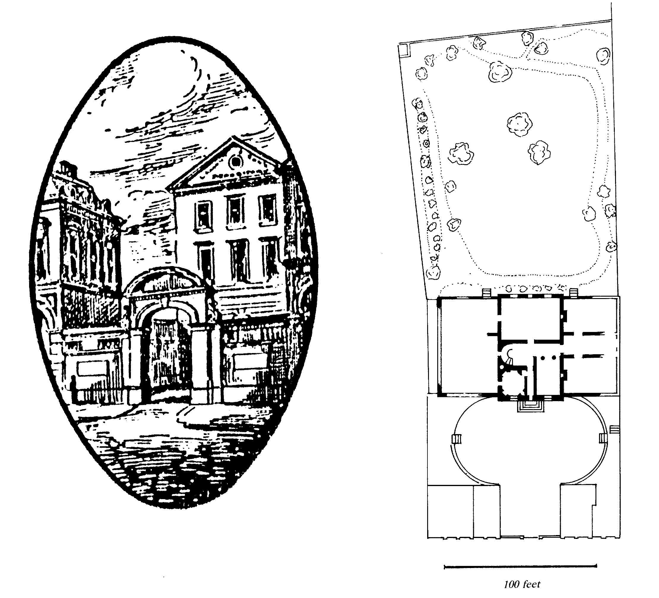
Forest house
Several important commercial buildings were put up to serve the cloth fairs of the later 18th century. They included the New Linenhall, a large rectangular brick building comprising small shops around a courtyard and erected in 1778 on the eastern half of the Greyfriars site. (fn. 91) The lane leading to the Crofts, Lower Lane, was renamed Linenhall Street and perhaps remodelled. (fn. 92) In the early 19th century similar structures of brick with galleried courtyards were built on either side of Foregate Street: the Union Hall (1809) to the south and Commercial Hall (1815) to the north. (fn. 93) A further venture, managed by a committee on behalf of the proprietors, was the Commercial News Room (in 2000 the City Club), built in 1808 on the site of the Sun Inn next to St. Peter's church in Northgate Street. Designed by Thomas Harrison in a neo-classical style, it was of brick with an ashlar front of three bays, adorned with Ionic columns carrying a pediment, and with a rusticated ground arcade behind which a walkway was inserted in the 1960s. Inside there was a fine neoclassical news room. (fn. 94)
Despite the cutting of a canal through Chester in the 1770s and the 1790s, in part on the line of the old town ditch immediately outside the north wall, (fn. 95) new industry left only a limited imprint on the city's fabric. By the early 19th century there was some industrial building around the Gorse Stacks, including a needle factory and a foundry. (fn. 96) The Dee Mills, although by then in terminal decline, still dominated the riverside around Dee Bridge; five storeys high and with numerous iron-framed windows, they formed an impressive but starkly utilitarian complex. (fn. 97) By the canal, the Steam Mill, which originated in the late 18th century as a cotton mill but was used as a corn mill from 1819, (fn. 98) probably occupied a low fourstoreyed building still surviving in 2000. Another major enterprise initiated in the period was the leadworks, established in 1800 on a large site on the north bank of the canal; the shot tower, still a Chester landmark in the 1990s, dated from its earliest years. (fn. 99) The Flookersbrook foundry in Charles Street, which originated in 1803, added to the industrial character of the area north-east of the city centre. (fn. 100)
To the west of the walled city the New Crane Wharf on the river Dee, with its large warehouses and harbour master's house, was mostly developed by 1772 and remained largely intact into the 1990s. (fn. 101) From 1804 further industrial development was spreading along the riverside edge of the Roodee south of the workhouse of 1759: shipbuilding yards and an iron foundry before 1815, and a paper mill by the 1830s. (fn. 102) At Tower Wharf on the canal, warehouses, a hotel, and a dry dock were built shortly after the opening of the Ellesmere Canal's Wirral branch in 1795. Much of the site survived in 2000. (fn. 103)
New Churches and Chapels, 1760-1840
Repairs to some of the parish churches made a visual impact on the city, in particular the reconstruction of the south side of St. Peter's after the removal of the Pentice in 1803, and the removal of the spires of St. Peter's in 1780 and Holy Trinity in 1811. Old St. Bridget's, by then very decayed, was demolished in 1829 and replaced by a neo-classical church opposite the castle in the angle between Grosvenor Street and Castle Esplanade. New churches were built in the growing suburbs of Boughton in 1830 and Newtown in 1838. (fn. 104)
Non-Anglican places of worship were also opened in areas of expanding population. In Queen Street, for example, a Congregationalist chapel opened in 1777 and a Roman Catholic church in 1799. Notable nonconformist chapels serving relatively well-to-do neighbourhoods included the Octagon chapel opened in 1765 north of Foregate Street near the Bars, the Wesleyan chapel in St. John Street designed by Thomas Harrison in 1811, and the Methodist New Connexion chapel opened in Pepper Street in 1835. (fn. 105) Less prestigious denominations built smaller, architecturally undistinguished chapels in inconspicuous locations, such as the Particular Baptists in Hamilton Place (1806), the Primitive Methodists in Steam Mill Street (1823), and the Scotch Baptists in Pepper Street (1827), or made do with converted buildings. (fn. 106)
Residential Development, 1760-1840
Although the centre of Chester bears much evidence of later 18th-century rebuilding, completely new housing was limited to a few speculative developments, and the city had no substantial Georgian suburbs. In the earlier 19th century population growth provoked rather more rebuilding and Chester's housing stock expanded by over half between 1801 and 1841. (fn. 107) Much building took the form of infill on sites within the existing urban framework; small or medium-sized cottage property predominated. Such developments included the courts and, like the leadworks, detracted from the city's character. (fn. 108)
The best housing within the intramural area in the later 18th century was in the cathedral precinct and on the Greyfriars and Blackfriars sites. At the cathedral, work continued after the completion of Abbey Square, in Abbey Green in the 1760s and 1770s and Abbey Street until the 1820s. (fn. 109) The Greyfriars site was developed after its sale by the Stanleys in 1775. The principal houses, which were on the western half of the site, comprised two opposing red-brick terraces, three storeys high, on either side of Stanley Place, and similar dwellings at Watergate Flags on the Watergate Street frontage. (fn. 110) The project also entailed the laying out of Stanley Street and probably of City Walls Road, which extended by 1789 from Watergate Street to the northern edge of the site. (fn. 111)
The Stanleys, together with the architect Joseph Turner, were also involved in development on the Blackfriars site, where in the 1780s a substantial brick terrace, designed by Turner, was erected fronting the western side of Nicholas Street. (fn. 112) Behind, between the gardens of the terrace and an earlier house belonging to Sir Richard Brooke, a service road known originally as Brooke's Street and later as Nicholas Street Mews was set out. Further development included the reconstruction of Brooke's house in 1820 by the architect Thomas Harrison for Henry Potts, the county treasurer. (fn. 113) By the late 18th century Smith's Walk (later Grey Friars) had been laid out to the south to provide access to the large house which had long existed in the south-west corner of the precinct. (fn. 114)
Other late Georgian work within the city centre included further development in King Street (relatively genteel), White Friars, and Pepper Street (distinctly modest). (fn. 115) Within the Rows there was a good deal of rebuilding in the late 18th and early 19th century, mostly in brick, often rubbed, and adorned with continuous cills forming strings. Many houses or facades of the period survive in Bridge Street, Watergate Street, the south side of Eastgate Street, and the east side of Northgate Street. (fn. 116)
By the later 18th century the intensified development of sites within the old city centre led to its desertion by Chester's wealthiest inhabitants. Gamul House in Lower Bridge Street, for example, had ceased to be a private residence by the 1760s and was occupied by a dancing academy and a boarding school; by 1831 the house and its outbuildings were divided into inferior dwellings. (fn. 117) Stanley Palace, which in the mid 18th century was occupied by the Hesketh family and frequented by the gentry during race week, was by the 1830s in the possession of two builders and described as 'decayed'. (fn. 118)
Although the periphery, including Foregate Street, continued to include some large houses in the later 18th century, (fn. 119) much of the suburban building around Chester between 1760 and 1840 was relatively modest. One of the earliest and best developments was outside the Watergate on corporation land, where a new road was laid out in 1763 and building leases were available from 1766 onwards. The corporation was concerned that the houses should be of a uniform appearance and in 1769 laid down minimum standards for materials and design. (fn. 120) The new houses, which were in Crane Street and on the north side of Paradise Row, were described as among the most pleasant in the city in 1831. (fn. 121) Although an attempt to extend housing northwards on to Tower field came to nothing, perhaps because it was found that some of the existing houses were liable to occasional flooding, new commercial development on the river bank was actively encouraged. (fn. 122)
Outside the Northgate, Upper Northgate Street was already by the 1770s lined with houses, some of them of size and quality, as far as the junction of Parkgate and Liverpool Roads. (fn. 123) West of Parkgate Road in the 1830s the land remained open on either side of the former Portpool Way, renamed Cottage Street (later Garden Lane), (fn. 124) but by 1830 middle-class housing was beginning to spread over the dean and chapter's land along Liverpool Road, including a short early 19th-century terrace named Abbots Grange, and a few large villas such as Abbot's Hayes and Abbotsfield, both later demolished. (fn. 125) Further east much of the new building was terraced cottages. To the south of St. Anne Street, for example, where a few early 19th-century houses survived in 2000 amid later redevelopment, streets of small terraced houses were built by local investors, notably Thomas Clare, a builder of Oulton Place who was elected to the council in 1836. (fn. 126) By 1831 the area, then known as Newtown, contained over 500 houses. (fn. 127) There had also been scattered housing and commercial development along the north bank of the canal and Brook Street in the later 18th century, (fn. 128) and in the early 19th century terraces of small houses were built off the north side of George Street and around the bowling green behind the Bowling Green Inn at the Gorse Stacks. (fn. 129)
Although the land between the south bank of the canal and the gardens to the north of Foregate Street was still fields in the 1770s, (fn. 130) development started there before 1800. Queen Street was the first to be built up, by John Chamberlaine and Roger Rogerson after 1778, (fn. 131) but the earliest planned development was Bold Square, built c. 1814 by Thomas Lunt, a foundry owner and builder, and comprising two terraces of small houses facing each other across a strip of garden. Lunt also erected Union Bridge across the canal at his own expense and on the north bank built much of Egerton Street (c. 1820), which included a terrace on the west side and five pairs of slightly larger semidetached houses on the east. South of the bridge, Seller Street was developed in 1818-19 by the brewery owner Alderman William Seller. (fn. 132)
To the south of Foregate Street, St. John Street, in the early 19th century 'dark, narrow, and incommodious', was improved after the building of the Wesleyan chapel in 1811, and by 1831 contained 'many genteel residences'. Further east in Boughton, near the site of St. Paul's church, Richmond Terrace was an imposing late Georgian development, and nos. 125-7 Boughton an early 19th-century one, of three storeys with a balcony carried on coupled Tuscan columns. To the south, on the high ground above the river, Thomas Harrison designed Dee Hills, a two-storeyed stuccoed villa, for Robert Baxter in 1814. (fn. 133)
South of the river, Handbridge contained mostly working-class housing by the early 19th century, (fn. 134) though still including Netherleigh, the moated mansion of the Cotgreave family on Eaton Road. Further out on Eaton Road was Greenbank, an impressive neoclassical house with a stuccoed front of two storeys and seven bays, built by Alderman J. S. Rogers in 1820. (fn. 135) Over to the west, Overleigh Hall, the home of the Cowper family, was purchased from their heir and demolished by the 2nd Earl Grosvenor c. 1830. (fn. 136)
The Courts
The growing subdivision of once grand town houses and the insertion of small dwellings into much of the available space, and especially into back gardens, gave rise in the city centre to slum courts (fn. 137) which came to pose a problem as severe as that in the region's industrial towns. (fn. 138) At the time of their greatest extent in the 1860s and 1870s, Chester had 178 courts lacking effective street frontage, generally with access only by a passage through other property. Although it is difficult to date precisely, such housing was probably built mostly between the earlier 18th century and the 1840s. Within the walls much dated from before 1789. (fn. 139) Building took place in back yards and gardens between Watergate Street and Commonhall Street, behind Shoemakers' Row in Northgate Street, and in Lower Bridge and Castle Streets. In the 1790s and more especially in the early 19th century courts were built further from the main streets, for example north of Watergate Street off Goss, Crook, Trinity, and Princess Streets. A further group behind St. Olave and Duke Streets also seems to date from that period. (fn. 140) Within the walls only the north-eastern quarter had few courts, their development being inhibited by the cathedral precinct and the commercial value of sites along and behind Eastgate Street. Beyond the walls an extensive network of courts also developed on both sides of Foregate Street, and in the 19th century more were built in Boughton and behind Upper Northgate Street, and a few in Newtown. The largest number of later courts outside the city centre was in Handbridge. (fn. 141)
Court building reflected the surge in the city's population after 1800 and continued until effectively prohibited by the 1845 Chester Improvement Act. The owners of courts increased accommodation, particularly for migrants, by packing more people into existing properties, by subdividing the buildings, and by inserting new dwellings into the remaining open spaces. The population of the intramural parishes of St. Olave's, St. Michael's, and St Peter's, each with much court housing, peaked in 1821 and declined somewhat thereafter as the number of migrants faded and some residents found better accommodation elsewhere in the city. (fn. 142)