A History of the County of Cambridge and the Isle of Ely: Volume 4, City of Ely; Ely, N. and S. Witchford and Wisbech Hundreds. Originally published by Victoria County History, London, 2002.
This free content was digitised by double rekeying. All rights reserved.
T D Atkinson, Ethel M Hampson, E T Long, C A F Meekings, Edward Miller, H B Wells, G M G Woodgate, 'City of Ely: Introduction', in A History of the County of Cambridge and the Isle of Ely: Volume 4, City of Ely; Ely, N. and S. Witchford and Wisbech Hundreds, ed. R B Pugh (London, 2002), British History Online https://www.british-history.ac.uk/vch/cambs/vol4/pp28-33 [accessed 30 April 2025].
T D Atkinson, Ethel M Hampson, E T Long, C A F Meekings, Edward Miller, H B Wells, G M G Woodgate, 'City of Ely: Introduction', in A History of the County of Cambridge and the Isle of Ely: Volume 4, City of Ely; Ely, N. and S. Witchford and Wisbech Hundreds. Edited by R B Pugh (London, 2002), British History Online, accessed April 30, 2025, https://www.british-history.ac.uk/vch/cambs/vol4/pp28-33.
T D Atkinson, Ethel M Hampson, E T Long, C A F Meekings, Edward Miller, H B Wells, G M G Woodgate. "City of Ely: Introduction". A History of the County of Cambridge and the Isle of Ely: Volume 4, City of Ely; Ely, N. and S. Witchford and Wisbech Hundreds. Ed. R B Pugh (London, 2002), British History Online. Web. 30 April 2025. https://www.british-history.ac.uk/vch/cambs/vol4/pp28-33.
City of Ely (fn. 1)
'Elge', meaning eel-district, appears to be the correct origin of the name, though willow-place (fn. 2) and eel-island are explanations almost equally apt. An outlier of Lower Greensand, partially capped by boulder-clay and gravel, formed the island on the eastern edge of which the city of Ely developed, rising from the 'waste of waters opening wide' which, in early times, occupied the hollows of the underlying base of Kimmeridge clay. Though many species of fish abounded, (fn. 3) eels were much the most prolific product of the fenland waters and formed an important source of food and income from the beginnings of the monastic settlement.
The high ground on which the cathedral stands still permits the city to dominate the plain for many miles. Ely lies mainly on the western bank of the River Ouse, some 3 miles from its junction with the Lark and, until the advent of the railways, depended for its development largely on easy access by water, northwards to Wisbech and Lynn and southwards to Cambridge, numerous tributaries communicating with most of the Midland river systems. (fn. 4)
Ely is some 16 miles north by east from Cambridge and about 71 miles from London, on what was until 1948 the L.N.E. railway. It is an important rail centre. The main line from the south bifurcates here, one arm going northwards to King's Lynn and the other northeastwards to Norwich. Lines also radiate north-westwards to Peterborough, south-eastwards to Newmarket, and south-westwards to St. Ives. A loop line (the Adelaide loop) leaves the line from Peterborough at Waterden Fen and joins the Lynn and Norwich lines south-west of their junction. This loop was constructed in 1890 (fn. 5) presumably to enable traffic from Norwich and Lynn going northwards via Peterborough to bypass Ely and avoid reversing engines. The railway station dates from 1845. (fn. 6) Its original 'Italian' design was much admired at the time of construction. (fn. 7) The building has subsequently been much altered. (fn. 8) British Railways is one of the more important employers in the city.
The city is traversed by the London to King's Lynn road (A 10) and is connected on the south-east with Soham and on the west with Chatteris by roads (A 142) of lesser importance. A road also leads northward to Downham and another north-eastwards to join the Littleport-Mildenhall (Suff.) road (A 1101). The second of these crosses the Lark at Prickwillow which is there spanned by a bridge-the successor of one which existed in 1677. (fn. 9)
Ely never acquired the status of an incorporated borough. (fn. 10) Since the Local Government Act of 1894 the city, with its environs, has been governed by an Urban District Council. The College Precincts formed an extra-parochial entity until 1933 and since then have been a separate civil parish though under the control of the Urban District Council. Only on one occasion, in 1295, did the city elect its own parliamentary representatives. (fn. 11)
The major significance of the city, despite some modern industrial development, is still its position as head of the episcopal see and centre of an agricultural area. The modern plan of the city follows remarkably closely the broad layout of medieval times. (fn. 12)
The built-up area of Ely itself comprises only about 1 square mile of the 24 within the boundaries of the Urban District. There are, however, several subsidiary settlements. Chettisham is a very small hamlet 2 miles north-west of the city on the road to Lynn. It comprises little but a church, a few farms and cottages, and a railway station. Stuntney stands on an abrupt island in the fen 1½ mile south-east on the Soham road. It is a compact little village of the ordinary East Midland type, with the church and the hall much in evidence. Two other hamlets lying north-east of the city are much more characteristic of the Fens. (Queen) Adelaide, about 2 miles out, is entirely modern, and named from a public house. (fn. 13) The Ely sugar-beet factory is here. Prickwillow, 4 miles east-north-east from the city near the junction of the Lark and Ouse, is mentioned in 1251, (fn. 14) but has only become a place of importance in the last 150 years. Situated in one of the lowest parts of the Fens, it has a curiously un-English look. Owing to the drainage operations the soil is shrinking at the rate of 2 inches a year, and the church, school, and other houses are built on piles. Where piles have not been used, subsidence and even collapse have often occurred. So high is the water table that the dead have to be buried in the city cemetery on the high ground 4 miles away. Farther out still are the scattered settlements of Burnt Fen and Shippea Hill, 8 miles from the city centre and on the Suffolk border. Here there is a railway station, opened in 1845 as Mildenhall Road. In 1885 its name was changed to Burnt Fen, and about 1904 to Shippea Hill. (fn. 15)
Nothing survives of Ely CASTLE, save the conspicuous mound (Cherry Hill) on the south-west side of the cathedral park. The remains belong to the motte-and-bailey type of fortress, and have been held to be those of a royal castle built by William I to maintain the submission of the Isle. (fn. 16) There seems, however, to be no ancient testimony to a castle, (fn. 17) other than that at Aldreth, earlier than the time of Henry I. This king allowed the service of castle-guard, due from the Ely knights and hitherto performed at Norwich, to be given 'at the castle of the (recently created) bishopric of Ely'. (fn. 18) The site and nature of this castle are obscure. It has been suggested that it gave its name to the later wellknown Castelbrigge and Castlehythe and was itself situated near the river and had no prolonged existence. (fn. 19) Certainly the distance of the precinctual mound from the river seems to rule out any connexion between this site and the bridge or wharf. During the Civil War of Stephen's reign, Bishop Niel is stated to have made 'a strong fort of lime and stone', within the precincts of Ely, but 'that fort being often destroyed, he built one of timber and walled in the round hill-called the keep'. The castle presently surrendered to Stephen. In 1144 Geoffrey de Mandeville was placed in charge of this castle and that at Aldreth, by authority of the representatives of Bishop Niel, who was absent at Rome. (fn. 20) A castle was said to have been taken and destroyed by Falk de Breauté, in 1216, (fn. 21) but during the baronial struggles half a century later, Ely with its fortifications was captured by Prince Edward, in 1268, (fn. 22) and it has generally been supposed that the castle built by Bishop Niel was demolished soon afterwards. According to Bentham, however, there was already a windmill on the mound in 1229. (fn. 23) Certainly no existing castle was recorded in the extent of 1251, but a messuage then stood 'where the old castle was' (fn. 24) -a statement which does seem to indicate a castle nearer to the river than the mound. In 1586-7, 6s. was spent on repairing 'the castle'-presumably the mound. (fn. 25) A windmill was depicted on Mount Hill on Speed's map of 1610. The hill was known as Mill Hill in 1649, (fn. 26) and by its modern name of Cherry Hill at least as early as 1821. (fn. 27) In 1779 it was crowned by a monumental pillar to the Revd. James Bentham, historian of Ely. (fn. 28)
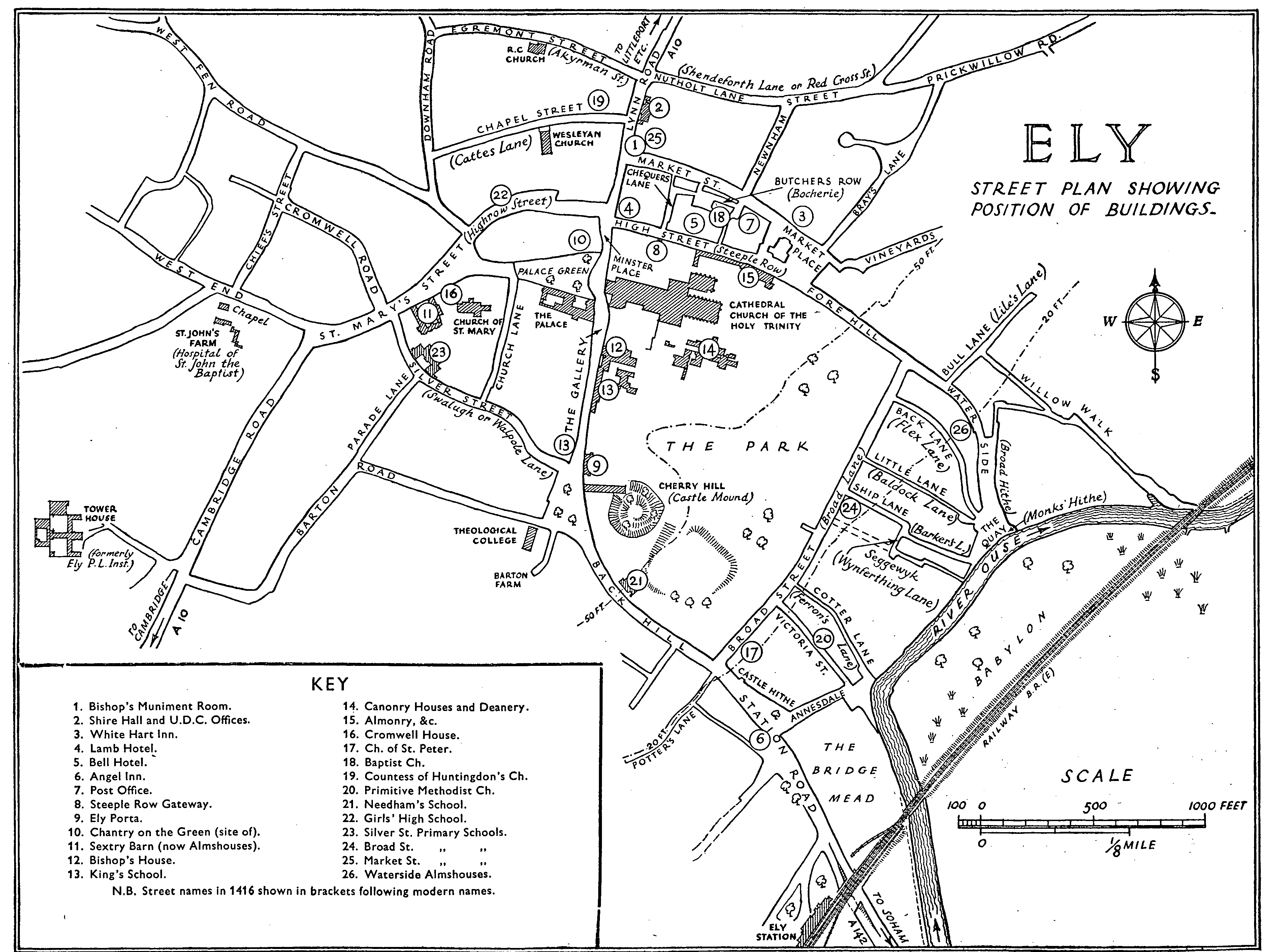
ELY street plan showing position of builldings.
Based upon the ordnance Survey Map with the sanction of the Controller of H.M. Stationery Office. Crown copyright reserved
The former HOSPITAL OF ST. JOHN BAPTIST is situated in West End. (fn. 29) The remains consist of three buildings of medieval origin now incorporated in a farmstead. In the 12th century there existed in close proximity the hospitals of St. John Baptist and St. Mary Magdalene, which were amalgamated by Bishop Northwold about 1240 under the title of the Hospital of St. John Baptist. By Northwold's ordinance the foundation was to consist of thirteen chaplains and brethren. It was suppressed in 1561, when the site was granted to Clare College, Cambridge, to which it belonged until sold in the present century to a Mr. Runciman. The last Master, Edward Leeds, was also Master of Clare College. The surviving remains date in origin from the early 13th century, before the amalgamation of the two foundations. Two of them are in fairly close proximity but the other is about 130 yards farther to the west. It seems probable, therefore, that portions of both the original hospitals are in existence, more especially as two of the surviving structures are obviously of ecclesiastical origin.
The most important of the remaining buildings, believed to have been the chapel of St. Mary, stands to the north of the farmhouse. It is now a simple rectangular structure measuring 41 by 25 ft., and was apparently the nave of the hospital chapel. There is now no clear evidence of a chancel. The lateral walls were probably originally somewhat higher than at present. The north wall alone retains definite pre-Reformation work in situ, the other walls being apparently rebuilt, but largely with old material. The windows, doorway, and stepped gables of Barnack stone and brick date from the 16th-century reconstruction, when the chapel was converted into a dwelling, and no trace remains of the original doorways and windows. The roof, which is tiled, seems to be an 18th-century reconstruction. A floor was inserted in the 16th century, with massive beams having stop chamfers. The north wall contains a blocked arcade of three bays, which proves the existence of an aisle now completely destroyed except for the foundations of the north wall, which show that it was 10 ft. 9 in. in width. After the destruction of the aisle massive stone buttresses were erected to support the nave wall; these buttresses are obviously composed of older material. The fact that the east arch of the arcade springs so close to the east wall that there is nothing to resist the thrust shows that the building was originally longer. The present east wall dates from the 16th century, but contains much old material including drums of Barnack stone, which must have formed part of columns. In the south wall over the doorway is a fluted piscina. The north arcade consists of two-centred arches with clustered columns and moulded caps and bases. All the windows belong to the 16th century; in the north wall there are three in the upper story of two uncusped lights, the heads of which are formed by the apex of the arches of the blocked arcade; below are three windows, two of which are of two lights and the other of four lights; in the east wall are two windows, the upper of three lights and the lower of two, both now blocked; in the upper part of the west wall is a threelight window. At the apex of the east gable is a double chimney-stack set diamond-wise on a square base. Within is a fireplace on each floor with chamfered stone jambs and wooden lintel. At the east end of the south wall is a plain 16th-century wooden doorway. The west gable is entirely of brick. The west wall has two brick buttresses, and in the thickness of the wall are two fireplaces; that on the ground floor is situated in the centre, while the upper is placed to the south of the window and has been partly destroyed by a later doorway; the chimney-stack has disappeared, and its place is taken by three steps of different brick to the rest of the gable.
To the south-east of the chapel is a structure of Barnack stone measuring 20 by 19 ft. Low down in the east wall are two blocked arches of clunch, and there are traces of a blocked arch in the north wall. The present roof, which is tiled, is probably of 17th-century date and shows that the building has served at some time as a pigeon house; its original purpose is unknown.
The third structure of medieval origin, believed to have been the chapel of St. John, is situated about 130 yards to the west of the first. It is built mainly of rubble with Barnack dressings. The roof is tiled and hipped at the east and west; it is of modern construction. The building measures 53 by 24 ft., and it seems fairly certain that it was originally a chapel before the amalgamation of the two hospitals. It is of very early 13th-century date. In the north wall are four plain lancets, now blocked, with jambs of Barnack stone and heads of clunch; the internal arches are widely splayed. Between the third and fourth windows is a plain blocked doorway of one order with continuous chamfer and a hood terminating in masks. Over the doorway is a rude carving in relief depicting a man riding backwards on a cross-horned animal and blowing a horn. It has been claimed that this formed part of Etheldreda's monastery. (fn. 30) The west wall is quite featureless. In the south wall is a blocked doorway opposite to that on the north, and there are traces of similar lancets, all now blocked. A large wagon opening has been inserted in the south wall. In the east is a large shallow recess, which in all probability represents a former wagon entrance which was blocked when that on the south side was made. Traces of former lancets in clunch can be seen on either side of the recess. In a wall close to the building is a piece of Roman millstone.
The farmhouse seems to date from the second half of the 17th century, and probably replaced the desecrated chapel as a dwelling. It is largely constructed of old material.
The prior is said to have had a prison in 1229. (fn. 31) Certainly there are frequent references to it in the 14th century (fn. 32) and its existence is noted in 1417. It was situated in the porter's lodge of the Ely Porta. (fn. 33)
The bishop's prison, which was probably also his jail for the Liberty, is mentioned in 1276, (fn. 34) 1376, (fn. 35) 1394, (fn. 36) and early in the 15th century. (fn. 37) This prison, or a later one which stood at the corner of 'Jail Lane', (fn. 38) was partly rebuilt by Bishop Mawson in 1768 (fn. 39) in consequence of a public inquiry into the severe measures taken to prevent escapes. It was visited by John Howard, who in 1777 catalogued its illegal deficiencies. (fn. 40) On James Neild's visit in 1810 marked improvement had been effected. (fn. 41) On the abolition of the Liberty in 1837 the building ceased to be used as a prison. (fn. 42) From c. 1842 until c. 1879 the Ely Mechanics' Institute appears to have been housed in it. (fn. 43) It is now used as the Diocesan Muniment Room, and the floor rings, by which prisoners were secured, may still be seen.
The city bridewell was built in 1651. (fn. 44) The conditions as observed by Howard were even worse than those prevailing in the bishop's prison (fn. 45) and at the time of Neild's visit little progress towards correcting them had been made. (fn. 46) The building presumably ceased to be used as a prison in 1820 when the new sessions house was built. Its subsequent fate is uncertain but it was perhaps converted into a barn prior to demolition in 1850-5. (fn. 47)
In 1820 a new sessions house or shire hall, and house of correction were built on the Lynn Road. Changes were made in these buildings in 1843 when a separate house of correction, containing 35 cells, was built at the back of the shire hall and the prison chapel in the south wing converted into a police station. (fn. 48) Between 1865 and 1869 the north wing was partly appropriated by the Volunteers for use as an armoury, and was taken over entirely for this purpose when, in 1878, the house of correction was closed under the Prisons Act of the previous year. (fn. 49) The Volunteers gave up their tenancy in 1908. (fn. 50) The shire hall, which is still used as a court, now also houses the U.D.C. Offices besides the police station.
The White Hart Inn on the north side of the market place is of 15th-century origin, but the original plan and details have been much obscured by rebuilding and later additions. It is at present L-shaped, but it is not improbable that originally there were two wings at the back. The roofs are covered with blue slates, except a gallery at the back, which is tiled. The front is now faced with brick and stucco, and a second story was added, probably at the end of the 18th century. The main portion of the north wing is entirely of brick and is of 19th-century date, but to the north of this portion is an early 17th-century structure containing the kitchens on the ground floor, beneath which is a cellar with a plain barrel vault of brick. All the fenestration is modern, but in the 17th-century section there are indications of the original windows, now blocked. The entrance passage from the street is the most interesting feature of the house. It retains late 15th-century timber framing, including one moulded angle post and principal with a bracket on the east side springing from a defaced stone corbel; there are wide joists and chamfered wall brackets. The passage has been curtailed on the west, and the brackets and angle posts on this side are no longer visible. At the back of the main block is a gallery on the first floor which, though modernized, is probably part of the original structure. The two rooms on the ground floor to the east of the entrance probably formed the hall of the medieval house, and there is a large cased-up beam in the ceiling. The 17thcentury block retains an old chimney-stack of brick, and there is a stop-chamfered beam in the kitchen ceiling. The main staircase dates from the end of the 18th century and has a contemporary rail. In a room on the first floor of the main block is a good wooden fireplace of Adam character. The inn formed part of the property bequeathed by Catherine Needham in 1730, for the maintenance of her school (see below-Schools).
No. 5 Market Place, adjoining the 'White Hart', is a timber-framed house probably of 16th-century date, with a brick front added in the 18th century. There is a large wing at the back, also timber-framed except for the end wall which is of stone; there is a considerable overhang on the west side. Most of the windows are modern but there is a small two-light with leaded panes at the back of the main block. There is a large chimneystack of brick, probably of 17th-century date. The building is now (1951) a fried fish bar.
No. 7 Market Place, adjoining the last, consists of a main block of early-18th-century date and of brick construction. There is an upper story surmounted by attics contrived in the high-pitched roof, which is tiled. One of the rooms on the ground floor has contemporary panelling smothered in brown paint. There is a long wing running at right angles at the back, which is timber-framed and of early-17th-century date, with a large contemporary chimney-stack of brick.
There is an interesting range of houses on the south side of the High Street to the east and west of Steeple Row gateway; they are partly timber-framed and partly of brick, and the roofs are tiled. The core of the structures is medieval, and it is probable that they originally formed part of the outbuildings of the monastery. After the Dissolution they were secularized and adapted for houses and shops. Most of the frontage appears to date from about the end of the 16th century, though greatly altered and faced up at a later date. Nos. 12 and 14 originally formed one house. Two rooms on the ground floor have chamfered beams and wide joists in the ceilings, and on the first floor there are some 17thcentury doors. There is a large brick chimney-stack at the back, which probably dates from the end of the 16th century. No. 18, which extends over the gateway to the Close, has been much modernized with the exception of the portion over the gate, which is of two stories. The upper story has a considerable overhang and there are two carved late-15th-century bressummers on the north and one on the south; the arms of Ely occur on the lower bressummer on the north. There is a 15thcentury wooden oriel window of three lights in the room on the first floor at the back, with moulded mullions and transom and a square head. No. 22 is built round a portion of 14th-century walling nearly 3 ft. thick, in the upper part of which are remains of two stone circular windows. There is a cellar beneath the back part of the house which is probably of late 16thcentury date.
The Lamb Inn at the corner of High Street and Lynn Road was a coaching-inn in 1753. (fn. 51) The 'Bell' in the High Street itself was in existence in the 16th century. (fn. 52)
Nos. 3 and 5 Silver Street, originally one house, are of stone with continuous tiled roof. The structure probably dates from the beginning of the 16th century. There is a base course, and the east gable retains its original stone coping. In this wall is a three-light window in the upper story with stone mullions and a square head. At the back is a four-light window under a square head, partly cut through to form a doorway. There are two small rectangular openings, now blocked, in the east wall, and a similar one at the back which is in use. Inside, there is a stone newel staircase in the north-east angle, and in one of the rooms a beam with stop chamfers. A chimney, probably of the 17th century, has been inserted at the east end. The windows and doorways in the front are modern. A range of four cottages abuts on the west end. They are timber framed and probably date from the beginning of the 17th century. There are several large chimney-stacks of brick, the easternmost of which has three flues set diagonally. The windows are all modern except one, which has a wooden frame and leaded lights, and is probably of 18th-century date.
The White Lion Inn, at the corner of St. Mary's Street and Silver Street, is of brick and rubble and dates from the second half of the 17th century. The front is plastered and the roof, formerly thatched, is now slated. The brick gables are corbelled out.
Nos. 8 to 12 Church Lane are a row of timberframed cottages of 17th-century date. The upper story has an overhang and is plastered. The lower story and the end walls are of brick. There is a large chimneystack of brick in the centre.
No. 20 Church Lane is a detached timber-framed house, probably of 16th-century origin. It has been extensively restored within recent years, and the windows with wooden mullions and the chimney tops of brick are all modern. The roofs are tiled.
No. 22 Fore Hill is a mid-16th-century house with two stories above the ground floor; it is probably of timber-framed construction, but the exterior is now plastered and the end walls are of brick with corbelled gables; the roofs are covered with tiles. The structure has been considerably altered and extended at various dates and the windows on the front are all modern, with leaded panes. One old window of three lights with moulded wooden mullions and frame remains in the back room on the ground floor, and now opens on to the stairs. The front room on the ground floor has chamfered beams and plain joists, which are probably of 16th-century date.
The Angel Inn, at Castle Hithe, is a modern building on the site of an earlier inn.
At Barton Farm, about 500 yards south-west of the cathedral, there formerly stood a fine timber barn, probably of medieval date. The. roof was thatched and the sides and west end were covered with modern weatherboarding. Two rows of upright timbers supported the roof, which had tie beams and collars and was carried down to within about 7 ft. of the ground. The timber framing of the sides and ends rested on a stone base. The barn was blown down in 1927 and the remains cleared away.
In Cromwell Road there is a stone-built barn probably of 16th-century date. The gables are of brick and the roof is tiled. There are narrow slits in all the walls and a large entrance towards the road with modern doors. The roof has old timbers.
There is a good early-17th-century house, known as the Manor, to the north of Stuntney church. The material is brick and the roofs are tiled. There is evidence on the south side that the structure was originally of greater extent. The front, which faces north, has a tall projecting porch, and the original plan was probably E-shaped. The windows have been modernized, as has the interior. On the north there are two large chimneystacks, one with two tops set diamond-wise. A large brick barn is attached to the north-east angle, and the western elevation has two gables. There have been serious settlements and the building is not in very good condition (1950).
Ely Theological College, (fn. 53) on the Barton Road, was opened in 1881, for the training of students for the Anglican ministry. It is of red brick in 'Gothic' style with stone facings.
The isolation hospital in St. John's road, the first hospital in Ely, was opened in 1917. It was erected at the sole cost of William and Mrs. Emily Ann Cutlack, and had 24 beds in 1937. (fn. 54) North of the town on Lynn Road is a large R.A.F. Hospital, established during the Second World War and retained since to serve the permanent air stations at Marham, Feltwell, Lakenheath, Mildenhall, and elsewhere.
There seems to have been some kind of post office in Ely as early as 1672. In this year unsatisfactory working from Cambridge is mentioned, (fn. 55) presumably owing to the dangerous state of the entries to the Isle at Stretham Ferry and Aldreth. (fn. 56) In 1851 the post office was in the market-place, and money order business was transacted. (fn. 57) A telegraph system was introduced in 1869, (fn. 58) on which the traffic had increased sufficiently by 1872 to make it necessary to appropriate the postmaster's sitting-room for the instruments. (fn. 59) A new post office was fitted up in 1884, after some public complaints about inadequate premises. (fn. 60) This post office was in Minster Place, (fn. 61) and an adjoining yard and stables were acquired in 1888. (fn. 62) These premises were held on lease only, and in 1896, two years before expiry, the existing (freehold) premises in Market Street were purchased. They were first occupied in 1897. (fn. 63) Ten years later a telephone service was provided by the post office. (fn. 64)