A History of the County of Cambridge and the Isle of Ely: Volume 4, City of Ely; Ely, N. and S. Witchford and Wisbech Hundreds. Originally published by Victoria County History, London, 2002.
This free content was digitised by double rekeying. All rights reserved.
T D Atkinson, Ethel M Hampson, E T Long, C A F Meekings, Edward Miller, H B Wells, G M G Woodgate, 'Wisbech: Introduction', in A History of the County of Cambridge and the Isle of Ely: Volume 4, City of Ely; Ely, N. and S. Witchford and Wisbech Hundreds, ed. R B Pugh (London, 2002), British History Online https://www.british-history.ac.uk/vch/cambs/vol4/pp238-243 [accessed 30 April 2025].
T D Atkinson, Ethel M Hampson, E T Long, C A F Meekings, Edward Miller, H B Wells, G M G Woodgate, 'Wisbech: Introduction', in A History of the County of Cambridge and the Isle of Ely: Volume 4, City of Ely; Ely, N. and S. Witchford and Wisbech Hundreds. Edited by R B Pugh (London, 2002), British History Online, accessed April 30, 2025, https://www.british-history.ac.uk/vch/cambs/vol4/pp238-243.
T D Atkinson, Ethel M Hampson, E T Long, C A F Meekings, Edward Miller, H B Wells, G M G Woodgate. "Wisbech: Introduction". A History of the County of Cambridge and the Isle of Ely: Volume 4, City of Ely; Ely, N. and S. Witchford and Wisbech Hundreds. Ed. R B Pugh (London, 2002), British History Online. Web. 30 April 2025. https://www.british-history.ac.uk/vch/cambs/vol4/pp238-243.
WISBECH
Wisbech is the largest and only corporate town in the Isle, and the nodal point for the whole marshland area comprised by south-east Holland and Norfolk west of the Ouse. It is situated on the Nene about 12 miles from its present outfall, 94 miles north of London and 40 from Cambridge by road. It is one of a series of settlements spaced at two- to three-mile intervals along the landward side of the 'Roman Bank' (fn. 1) which runs around the edge of the Wash from Lynn to Boston and beyond. Like all these settlements the parish was originally long and narrow, stretching some 9 miles from the old course of the Well Stream, which divided Wisbech from Walsoken in Norfolk, to the far end of Wisbech High Fen beyond Guyhirn, where the boundary marched with Whittlesey for a short distance.
From at least 1610 the area was divided into three 'watches'-Town and South Brink (Wisbech St. Peter) and Murrow or North Brink (Wisbech St. Mary). The fact that the three obtained £1, 15s., and 10s. respectively in a division of certain charitable funds in that year suggests their relative importance. (fn. 2) The borough has always been co-extensive with the parish of Wisbech St. Peter, and was by 1585 divided into ten wards (Timber Market, Church, Castle, South, Barton, White Cross, Old Market, Ship Lane, New Market, Mill), of which Barton, White Cross, and Old Market were on the left bank of the Nene. (fn. 3) These divisions have been obsolete since the reform of the corporation in the 1830's, but the names Castle, Timber Market, and South Brink have been preserved in three of the County Electoral Divisions which are comprised in the Borough.
Proposals were made in 1837 to reduce the borough to some 1,200 acres by detaching the south-western 'tail' of the parish and incorporating the portion of Walsoken already built over. These proposals, however, though supported by some of the Corporation, were not carried out, probably because the trial and disposal of offenders from the New Walsoken area, which was in Norfolk, presented complicated problems. (fn. 4) The old wards and the 'watches' were then replaced by the North and South Wards which lasted until the boundary alterations of the 1930's. (fn. 5)
By the Ministry of Health Provisional Orders Confirmation (Ely, Holland and Norfolk) Act, 1933 (fn. 6) considerable alterations were made. Portions of Leverington in the Isle and of Emneth and Walsoken in Norfolk, already much urbanized, were transferred to Wisbech Borough, and the more rural parts of the latter were transferred to Elm and to March Urban District. The effect of these Orders was to reduce the acreage of the borough from 6,477 to 4,617. The Borough is now divided into East, North, South, and West Wards.
Rights of intercommoning of stock existed (i) on Norwood Common, with the tenants of March in the Bishop of Ely's manor of Doddington, and (ii) in Sutton Fen with the tenants of the royal manor of Long Sutton (Lines.). Disputes, especially in the former case, sometimes led to bloodshed and slaughtering of livestock. Three letters dated 1561 and 1562 from Bishop Cox to his March and Doddington tenants, regretting their 'stowteness' and ordering them to restore the right of common to Wisbech, and a similar letter from Queen Elizabeth under the seal of the Duchy of Lancaster, in favour of Long Sutton and with a penalty of £500 for non-compliance, are copied into the concluding sheets of the Holy Trinity Gild Book. (fn. 7) The dispute with Long Sutton had been in progress as far back as 1487, when a commission was appointed to inquire as to the bounds and pasturage rights. (fn. 8) That with March and Doddington was not settled by Bishop Cox's letters; four tenants of Doddington manor refused to accept it and were sued in Chancery by various tenants on the Wisbech side of the fen. The Court finally (1569) upheld Bishop Cox's decision in favour of Wisbech. (fn. 9)
The town stands at the crossing of two Class A roads: from Peterborough to King's Lynn (A 47) and from Ely to Long Sutton (A 1101). The former is part of the important cross-country route from Leicester to Norwich and carries much traffic, particularly in summer to and from the east coast resorts. There are secondary roads to Parson Drove and Crowland (B 1169), March via Elm and Friday Bridge (B 1101), and Peterborough via Wisbech St. Mary (B. 1441). Another route to March, which leaves the main (South Brink) road to Peterborough (fn. 10) at Guyhirn, was turnpiked in 1730. (fn. 11) The road through Wisbech St. Mary to Thorney and Peterborough was turnpiked in 1810 and the Sutton road (from Tydd Gote through Wisbech to Downham Market) as late as 1849, (fn. 12) when it was diverted from its old course through Leverington village to its present one bisecting Spital Field. The repair of one of the roads to March, known as Lionell and later as Southewold causeway, was the subject of an indulgence in 1494. (fn. 13)
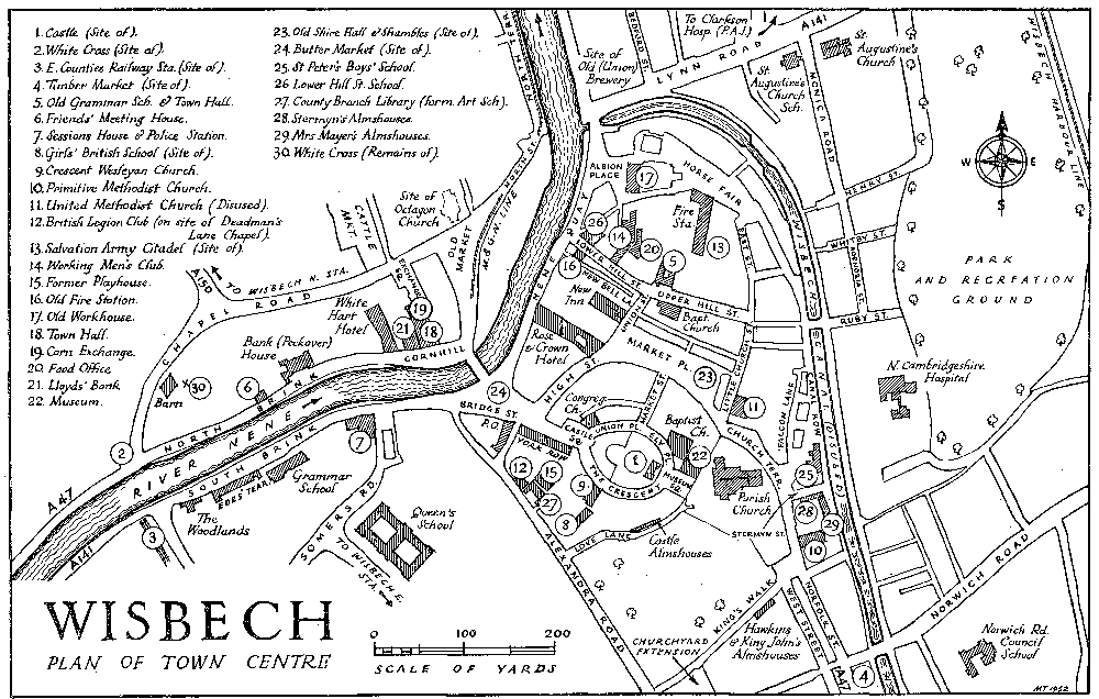
WISBECH PLAN OF TOWN CENTRE
Based upon the Ordnance Survey Map with the sanction of the Controller, H.M. Stationery Office. Crown Copyright reserved.
In 1796 there was a daily mail coach service to London, leaving at 4 p.m. and returning at 10 a.m., for which the fares were £1 5s. inside and 12s. 6d. outside, and there was also a stage coach three times weekly at 18s. and 9s. Until 1831, when the bank at Sutton Wash, by-passing Wisbech, was built, another coach ran on Tuesdays, Thursdays, and Saturdays from Lynn through Wisbech and Spalding to Boston. (fn. 14)
The first railway line to reach Wisbech, that from St. Ives and March, was opened in May 1847. (fn. 15) The original station was a terminus at the present sidings on the South Brink near the Grammar School, but in the following year the line was prolonged to join the East Anglian Railway at Watlington (now Magdalen Road) and a new station was opened on the site of the present East Station. (fn. 16) The two stations were both in use up to at least 1851, when they were 'temporary erections . . . conveniently situated at the south-east end of the town'. (fn. 17) They were used by the Eastern Counties and East Anglian Railways respectively. About the same time (1845-50) rival schemes for lines from Peterborough via Wisbech to Sutton Bridge were promoted by the Great Northern and Eastern Counties Railways. The former company proposed a new cut to the river and improved docks, but partly owing to the opposition of the Corporation to another bridge over the Nene below Wisbech which might hinder shipping, the Eastern Counties scheme was approved. The line, however, was not actually built until August 1866. (fn. 18) Each railway laid down branches to the quays for goods traffic, but the former Midland and Great Northern Line, terminating in the Old Market, is not now used, (fn. 19) and the Wisbech Harbour branch of the former Great Eastern Railway is used very little. (fn. 20) In 1884 the latter Company opened a 'steam tramway' of 4ft. 8½ in. gauge from Wisbech to Upwell. Its receipts, about £2,500 a year in the 1890's, were even then not sufficient to maintain it, but the line is still much used for goods traffic. Passengers were carried until 1928, when a motor bus service was substituted. (fn. 21)
Wisbech owed its existence to its situation at the point where the Well Stream joined the 'Wysbeck', the stream from which the town derived its name. The Well Stream, now represented by the Wisbech Canal, (fn. 22) formerly carried the main outfall of the Great Ouse. The diversion of the Ouse, however, to its present course in c. 1300 and the cutting of Moreton's Leam in 1478 have reduced its importance. The 'Wysbeck' on the other hand has now swollen into the main River Nene.
The central part of the town, between the two watercourses, is a good example of a manorial borough, with the site of the castle midway in the peninsula and dominating the Market Place.
The Old Market, so called as early as 1221, (fn. 23) suggests that some kind of trading centre existed in Wisbech in very early times. It is on the left (west) bank of the river, and is not very far from the large moat at the north end of Barton Field, which is the probable site of the Barton manor house. (fn. 24) This house must have been the administrative centre of the Ely estates in Wisbech prior to the erection of the castle and the division between bishop and convent in 1109.
From the 12th century onwards the New Market by the castle, which was the headquarters of the richer of the two Wisbech manors, has outstripped the Old Market as a centre of trade. By 1492 there were 115 tenants of the bishop in the New Market as compared with 32 in the Old. (fn. 25) It should be observed, however, that although at the present time most of the best shops are in the Market Place and its continuations High Street and Bridge Street, the Old Market still has a few open-air stalls on Saturdays, and is 'the important part of the town to which farmers from the locality gravitate'. (fn. 26) It contains many of the banks, solicitors' and auctioneers' offices, and seed and implement shops; and the cattle market and the former corn exchange are in the immediate vicinity.
A third market, for timber, was at the south-east end of the town. The site, close to the Well Stream, was convenient for unloading heavy goods, and the narrow blocks of buildings between the canal, Norfolk Street, (fn. 27) and West Street represent the sites of the stalls and booths of this market.
The 'Roman Bank' and the two streams meeting at Wisbech have determined the line of the main roads leading from the town, those to Long Sutton and Lynn following the former (fn. 28) and those to Guyhirn and to Elm, Upwell, and Ely the latter. In 1830 the town consisted mainly of a 'hard core' between the Market Place, the river and the canal, ribbon development along the Nene above the bridge in the shape of the North and South Brinks, (fn. 29) and the houses round the Old Market and along North Street. Lower down the river, Bedford, Russell and Chase Streets had been laid out and partly built up, and the suburb of New Walsoken had begun to develop along Norwich (formerly Marshland) Road. (fn. 30) By 1837 this suburb had some 280 houses, 'mostly dwellings of an inferior description', occupied by about 1,200 'persons of the labouring classes' employed in Wisbech. (fn. 31)
Another development east of the canal occurred in the 1840's, when Agenoria, Henry, Ruby, and Whitby Streets (fn. 32) were built. The second and fourth of these are named after Henry Whitby Pooley, a former owner of the land. (fn. 33) By 1867, when an official map was prepared by the Borough Surveyor, (fn. 34) other important developments had occurred. Such were (a) the streets near the East Station, around Albert Street, Victoria Road, (fn. 35) and Milner Road; (b) the first of the houses in and near Leverington Road and Harecroft Road (formerly Pickard's Lane), where the railway-opened in 1866-was again a factor; (c) the development along Lynn Road and in the streets leading off it. This continued rather later, and was encouraged by the creation of the park (1869); it has resulted in the coalescence of Wisbech and Old and New Walsoken into a single built-up area. Development was less rapid after about 1875, for the town was experiencing a temporary decline in population. In the 1880's, a writer referred to the difficulty she experienced in finding a small house in Wisbech 'because for years no new ones had been built'. (fn. 36) Towards the end of the 19th century King's and Queen's Roads and the adjacent area were developed for housing purposes out of an estate that had belonged to the Colvile family. Between 1919 and 1939 the main trends were the filling up of vacant spaces in this district, e.g. Kingsley Avenue and Hillburn Road, and intensified development along and off Elm Road, making a continuous stretch of houses from Wisbech through the northern end of Elm village to Emneth. Since 1945 a new suburb at Mount Pleasant Bank, north of the town, has arisen. The land surrounding the town is of great fertility, which has prevented its reckless use for housing purposes; the numerous Corporation housing estates e.g. in Weasenham Lane are small, and private enterprise has concentrated more on filling empty spaces in roads already laid out than on opening up new roads.
Although Wisbech became a corporate town in the middle of the 16th century, its population at the time seems to have been small, even compared with neighbouring places. The earliest return with any degree of accuracy is one made by the bishops of the various dioceses in 1563, (fn. 37) which credits Wisbech St. Peter with 242 householders and Wisbech St. Mary with 71. The town seems to have been about half the size of Cambridge (517 householders), and ranked below Ely with its hamlets (400) and Whittlesey (355 householders in the two parishes). Another ecclesiastical return, made by order of Bishop Compton in 1676, (fn. 38) showed 1,424 persons of communicant age in St. Peter's parish and 284 in St. Mary's; the comparable figures for Ely and Whittlesey were 2,371 and 2,021 respectively. It may perhaps be inferred that the total population of the borough (St. Peter's parish) was about 1,000 and 2,000 at these dates. The tendency of the town to double in size in about a century continued during the 18th century, and the census of 1801 showed 4,710 persons. The town was again about half the size of Cambridge (9,276), and had outstripped Ely and Whittlesey, both of which were just below the 4,000 mark. The first half of the 19th century was a very prosperous time for Wisbech, and in 1851 the population of the borough was 10,594. The increase of about 120 per cent. was similar to that of the Isle as a whole, but below that of Cambridge, where the population had just trebled to 27,803. A sudden decrease occurred in Wisbech between 1851 and 1861, of over 10 per cent. to 9,276. This was about twice as much as in Cambridgeshire generally, and was due no doubt to the damage done by railways to the trade of the port. For the next generation the population of Wisbech remained virtually stationary (9,395 in 1891). Since the 1890's the emergence of the Wisbech neighbourhood as the chief market-gardening area in England, and the development of ancillary industries (e.g. fruit canning) in the town, have led to a steady increase of about 30 per cent. The 1931 Census showed a population of 12,006 on the then existing area and of 15,129 on the present area of the borough. It seems that this increase, on a slightly lower scale, is continuing; the Registrar-General's estimates for 1938 and 1947 have been 15,620 and 15,910, and the preliminary figure of the 1951 Census is 17,430. (fn. 39) The figure at the National Registration of 1939 showed 17,599 persons in Wisbech. (fn. 40)
Various travellers have recorded their impressions of Wisbech. Pepys, who was visiting relations in the neighbourhood in 1663, thought it 'a pretty town', and commented upon its 'fine church and library, where sundry very old abbey manuscripts', and its 'fine house built on the church ground by Secretary Thurlow'. (fn. 41) William Cole, the Cambridge antiquary, who passed through in 1772, mentions that 'the buildings were in general handsome, the inn we stopped at [the Rose and Crown] uncommonly so . . .'. 'But the Bridge,' he added 'stretching Rialto-like over this straight and considerable stream, with a good row of houses extending from it, and fronting the water, to a considerable distance, beats all, and exhibits something of a Venetian appearance'. (fn. 42) John Byng in 1790, however, found Wisbech 'an ugly dull town, with a large canal through it in the Dutch taste' and his inn was bad and expensive; 'my horses could not eat the hay, and I could not drink the wine'. (fn. 43) Cobbett, who 'speechified' to about 220 people in the Playhouse in April 1830, called it 'a good solid town, though not handsome' and re marked the export of corn. (fn. 44) In 1837 the Commissioners on the Boundaries of Municipal Corporations noted that 'a spirit of improvement' was visible in every part of Wisbech, though they did not consider that the town was likely to increase much; the rural part of the borough contained only about ninety houses, many 'of such an inferior description that they are not rated at all' and the rest not much better. In the town, the best houses at this date were in the North Brink, the Crescent, Ely Place, and Yorke Row; the average annual value in the last three streets was £28 10s.; labourers' cottages in Horse Fair and the adjoining streets were worth about £6 per annum. (fn. 45)
The town has few examples of really ancient domestic architecture. The following buildings, however, contain features which may be dated to 1714 or earlier. (fn. 46) No. 8 Bridge Street; Nos. 6 to 8 Yorke Row (Messrs. Ream, Ollard, and Rawlinson's premises), which probably form the house occupied by Secretary Thurloe's sons, and which were used for the administration of the manor from the second half of the 17th century; (fn. 47) Nos. 28 and 29 High Street, and the New Inn, Union Street, both dating from about 1500 and some of the rare examples of timber-framed buildings remaining in Wisbech; the Old Grammar School, Hill Street; Nos. 49 to 51 Horse Fair, early 18th century and retaining the small windows at end which lighted the spiral brick staircase formerly found in this type of house; Ely House, Lynn Road, an early-17th-century country house; the Rose and Crown Hotel, 17th century with a fine early-18th-century staircase and Regency front, and a two-story outbuilding dated 1601; the vault below and outbuilding behind No. 29 Market Place, late medieval; Nos. 33 and 34, 38 and 39, and the George Inn (No. 35) Market Place; Nos. 3 to 5 Nene Quay; No. 97 Norfolk Street, dated 1701, with a 'Dutch' gable; the barn and remains (not in situ) of the White Cross in the grounds of Bank House; 'Woodlands', South Brink. Thurloe's rebuilding of the castle is represented by the entrance gateway and certain fittings in the present buildings and elsewhere, and part of the garden wall in Love Lane.
Wisbech is noteworthy for its fine street architecture of the Georgian and Regency periods. (fn. 48) The group of buildings along the North Brink, from the Town Hall to No. 25, is of exceptional merit, and the streets laid out between 1793 and 1816 on the site of the castle- The Crescent, Castle Square, Ely Place, Market Street, Museum Square, and Union Place-and the block of warehouses between the Old Market and the river, have architectural distinction not often found in towns the size of Wisbech. The general lay-out of the Castle Estate, with the 'circus' round the present castle expanding into squares at each end, with Market Street bringing the whole into relation with the town centre and street plan, is a good example of formal town planning. The buildings, which have not suffered much from later alterations, have no great architectural distinction in themselves, but are of just the right scale for their setting. An interesting reference to the development of this estate is found in Pigot's Universal British Directory (1792-6); (fn. 49) 'several houses are begun, and, if carried on upon the same scale as begun, will be a great ornament as well as addition and accommodation, and particularly as houses are now so scarce in this town.'
The row of buildings along the North Brink forms one of the finest pieces of Georgian street architecture in the country. Its effect is greatly enhanced by the river and its banks. The most noteworthy individual buildings in this group are the Town Hall and Bank (now Peckover) House. The former, built in 1810-11, under the Improvement Act of 1810, is distinguished by its stone front. The lower story is rusticated, with arched doorways and windows. The three centre bays project slightly and carry a pediment supported by four graceful Ionic pilasters; in the pediment is a round shield with the badge of the borough, St. Peter's Keys. Bank House, about 200 yards south-west, is a fine early 18th-century (fn. 50) town house, of three stories and five 'bays'. It is of light-brown brick with darker brick dressings, and the entrance doorway is of stone with a semi-circular pediment. At the top of the façade is a cornice and panelled parapet, supported at the corners by brick pilasters. The railings along the street front are original. Inside there are some fine rooms with mid-18th-century carving similar to that at Houghton Hall (Norf.). In 1943 the house, with 48 acres of land, was given to the National Trust by the Hon. Alexandrina Peckover, the last member of the great Wisbech banking family to live there. The intervening buildings are not individually so distinguished, but all are good architecture and contribute their share to the general effect. The White Hart Hotel and No. 12 North Brink are perhaps the most attractive individually. No. 14 (which with No. 19 was transferred to the National Trust in 1950) has a fine staircase. No. 6 (next the White Hart on the south-west) is interesting as being of two periods; the two lower stories are of the early 18th century, while the upper two were added between 1820 and 1840 in an exactly similar style. The modern building of Lloyds Bank fits into the terrace very well in scale and style. Beyond Bank House, the Friends' Meeting House, the gabled terrace (Nos. 22 to 25), and Sibald's Holme beyond the corner of Barton Road are interesting as having been designed by Algernon Peckover, another member of the banking family. (fn. 51)
The South Brink, though not so remarkable as the North Brink, has also several buildings worthy of attention. Nos. 7 and 8 date from the early 18th century, with a pediment added after 1756; they were originally one house. Inside there are some good fireplaces, a fine staircase, a panelled room and one with a good late 18th-century plaster ceiling, and a clock on the staircase, dated 1720 and with the weights and pendulum running in a channel cut in the thickness of the wall. No. 7 was the birthplace of Octavia Hill. The early 19th-century Sessions House and Police Station, on the opposite corner of Somers Road, are also good examples of their period. Ede's Terrace, Nos. 17 to 23, also early 19th century, is of somewhat unusual design, as also is No. 5 North Terrace, early 18th century with some Palladian windows with stone mullions and jambs.
There are many other 18th- and early-19th-century houses in Wisbech of more than average merit. No. 17 Hill Street, now the Food Office, is mid-18th century, with some rooms with original panelling. Nos. 19, 27, 30, 50, 52, and 54 Hill Street are similar to No. 17 but mostly rather later in date; No. 27 has a fine doorway, and the design of Nos. 50 to 54, with a high central archway running through two stories, is unusual-the building may have been erected as an inn. 'Flint House' (No. 67 Lynn Road) is an interesting little Regency Gothic house. Nos. 27 and 28 Market Place are some of the best buildings in a square where almost every one has some interest. The North Brink Brewery, c. 1790, is a good specimen of industrial architecture, forming a punctuation mark to the Brink terraces at the bend of the river. Until recently a somewhat similar building, the Old Brewery, stood at the corner of Lynn Road and Nene Parade. The Old Market has several good houses, notably Nos. 1 and 2, 9, 28 and 29, all late 18th century, and 'Sulehay House', c. 1730. 'Glan Dyfi', next door, is a successful imitation (c. 1890) of the Georgian style, harmonizing well with the older house. The Museum, though much later in date (1846-7) than the other buildings round the castle, fits into the scheme very well. It is interesting as one of the first buildings in the country designed as a museum; the architect was George Buckler. (fn. 52)
The early 19th-century development east of the canal, in New Walsoken and around Victoria Road, is mostly of a poor type. A later block, Nos. 1 to 5 Monica Road, c. 1875, is interesting on account of the 'ridge and furrow' type of roof, seldom found outside London. Its resemblance to contemporary terraces in such London suburbs as Finsbury Park and Shepherds Bush suggests that a London builder may have been responsible. (fn. 53)