A History of the County of Middlesex: Volume 1, Physique, Archaeology, Domesday, Ecclesiastical Organization, the Jews, Religious Houses, Education of Working Classes To 1870, Private Education From Sixteenth Century. Originally published by Victoria County History, London, 1969.
This free content was digitised by double rekeying. All rights reserved.
'The Physique of Middlesex', in A History of the County of Middlesex: Volume 1, Physique, Archaeology, Domesday, Ecclesiastical Organization, the Jews, Religious Houses, Education of Working Classes To 1870, Private Education From Sixteenth Century, ed. J S Cockburn, H P F King, K G T McDonnell (London, 1969), British History Online https://www.british-history.ac.uk/vch/middx/vol1/pp1-10 [accessed 30 April 2025].
'The Physique of Middlesex', in A History of the County of Middlesex: Volume 1, Physique, Archaeology, Domesday, Ecclesiastical Organization, the Jews, Religious Houses, Education of Working Classes To 1870, Private Education From Sixteenth Century. Edited by J S Cockburn, H P F King, K G T McDonnell (London, 1969), British History Online, accessed April 30, 2025, https://www.british-history.ac.uk/vch/middx/vol1/pp1-10.
"The Physique of Middlesex". A History of the County of Middlesex: Volume 1, Physique, Archaeology, Domesday, Ecclesiastical Organization, the Jews, Religious Houses, Education of Working Classes To 1870, Private Education From Sixteenth Century. Ed. J S Cockburn, H P F King, K G T McDonnell (London, 1969), British History Online. Web. 30 April 2025. https://www.british-history.ac.uk/vch/middx/vol1/pp1-10.
In this section
THE PHYSIQUE OF MIDDLESEX
Solid Geology, p. 2. The Drift Deposits, p. 3. The Conditions of Settlement, p. 8.
It is impossible to discuss the physique of Middlesex without some reference to the major region-the London Basin-of which it is a part. The boundaries of the ancient county were predominantly natural. The eastern, southern, and western boundaries followed the rivers Lea, Thames, and Colne. The northern boundary in the forest hinterland towards Hertfordshire followed the crest of a conspicuous but broken ridge from Batchworth Heath, near Harefield, via Oxhey to Elstree and thence eastward to within two miles of Barnet. Hertfordshire here extended south-eastward in the East Barnet valley, leaving to the north, however, the large parish of South Mimms in Middlesex. Eastward to the Lea no physical feature or change of landscape marked the boundary.
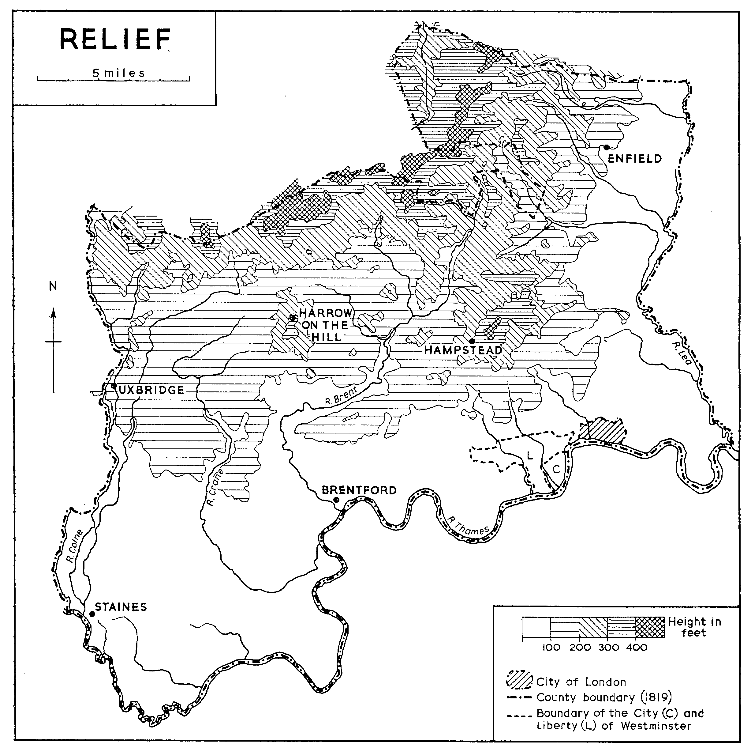
RELIEF
The highest points in the county lie along its northern border: Oxhey Hill (438 ft.), Harrow Weald Common (475 ft.), Bushey Heath (504 ft.), Deacons Hill, Edgware (478 ft.), and Highwood Hill (443 ft.). Further south Harrow Hill reaches 408 ft., Hampstead ('Jack Straw's Castle') 440 ft., and Highgate Hill 410 ft. The last two summits are the culminating points of a ridge running ENE.-WSW., continuing westward to Ealing and eastward to Hornsey (Harringay Station). This ridge forms the limit of the Thames valley east of Brentford and is a salient element in the topography of Greater London. Between it and the northern or county boundary ridge the country falls into two clearly marked divisions separated roughly by the line of Watling Street (Edgware Road). Westward lies a wide plain, rising from about 30 ft. O.D. on its Thames-side edge to 150 ft. at the foot of the northern ridge. It is diversified by isolated hills, as at Kingsbury Green (300 ft.), Barn Hill, Wembley (282 ft.), and Horsenden Hill (277 ft.). Eastward lies hilly plateau country dissected by well-marked valleys like those of Dollis Brook and Pymmes Brook, draining to the Lea. The general level of the plateau is 200-300 ft. O.D., exceeding the higher figure only at Muswell Hill, Whetstone, and Cockfosters. On its eastern side the plateau falls steeply to the trench of the lower Lea valley along a line close to Hornsey, Wood Green, and Enfield. The Lea follows a line on the eastern side of the valley floor which falls from about 100 ft. O.D. on its western side to about 40 ft. O.D. on the riverward edge; south of Tottenham the floor of the Lea valley is merged with that of the Thames.
SOLID GEOLOGY
Within the area so defined the succession of Eocene strata above the underlying Chalk is as follows: at the top, Bagshot Sands, then, in descending order, Claygate Beds, London Clay, Reading Beds, and Thanet Sands immediately over the Chalk.
The Thanet Sands, although conspicuous in south-east London, and thence to the Kentish coast, do not outcrop in Middlesex but thin out underground north-westward in the neighbourhood of Hendon and Finchley. The succeeding Reading Beds, comprising sands, pebble-beds, and brightly mottled red clays, are continuous underground. Together with the underlying Chalk, they outcrop at Harefield and around South Mimms, and in inliers at Ickenham, Ruislip, and Pinner. In these areas they give rise to a narrow belt of comparatively light or sandy soils, favourable to arable cultivation.
The familiar London Clay is in many respects the most important and characteristic surface formation of the county and even where it does not form the surface it is commonly present at shallow depth, where its impermeable character is revealed by the water held on the surface.
The upper part of the London Clay is appreciably sandy or loamy. This, 'the upper sandy London Clay' of certain older writers, is now distinguished as the Claygate Beds. The Claygate Beds form part of the upper slopes of the hills at Harrow, Hampstead, and Highgate. At these places the Bagshot Sands form the actual hill-capping, but at Stanmore, Elstree, Mill Hill, Totteridge, Arkley, and Cockfosters the Claygate Beds themselves form hill-cappings, in some cases succeeded by thin surface-gravels. Their presence is significant since they provide a natural brick-making mixture and yield soil lighter than the main mass of the London Clay, more readily amenable to arable cultivation, and supporting a rather different flora.
The Bagshot Sands are present only at the three places named above. These outliers are the remnants of a once continuous formation, still present in large amounts in Surrey, Berkshire, and Essex, but removed in Middlesex by denudation, i.e. in the course of the deepening and widening of the Middlesex valleys. Only where the Bagshot sands are locally preserved is the London Clay present in its full original thickness of 350-400 ft. (fn. 1)
THE DRIFT DEPOSITS
No treatment of the county as the home of man can fail to emphasize the superficial or 'drift' deposits which form the actual surface of at least half the county and have thus determined the character of its surface, whether for the first settlers in the area, or for the modern suburban builder. For present purposes the distinction between 'solid' and 'drift' deposits may best be expressed thus. The former constitute regular strata and provide the mass out of which the hills and valleys have been carved by the age-long activity of weather and water. The drift deposits have come into being during this process of land sculpture, being themselves the deposits of the present or former rivers or of the ice-sheet which entered the district during the Great Ice Age.
The drift deposits are all the product of the last and shortest of the recognized geological periods-the Pleistocene. They may rest on any of the older rocks of the 'solid' succession. The intervening periods of Tertiary time, Oligocene, Miocene, and Pliocene are quite unrepresented by deposits in the area. Either they were never accumulated here, or like the Upper Eocene (e.g. Bagshot) beds they have since been removed by denudation.
The Geological Survey distinguishes eight categories of drift deposits (map facing page 2) ranging in height from the highest hill summits to the alluvium (formerly marsh) of the riversides. The several deposits are not disposed like the older rocks in orderly, superimposed sheets. Their order of age is, broadly speaking, that of their elevation and for our present purpose we may adopt a simple three-fold grouping: Stage I being the deposits of the highest hill-tops or summit plateaux-the 'Pebble Gravel' of the Geological Survey; Stage II the glacial deposits, namely the boulder clay and associated gravels, found generally at the middle elevations (200-300 ft.); and Stage III the River Terrace gravels, and associated brickearth and alluvium, the deposits of former valley floors of the Thames and its tributaries.
Stage I: The Pebble Gravel
The Pebble Gravel, 6-10 ft. or less in thickness, caps the highest summits in isolated patches which are evidently the remnants of a once wide-spreading formation. Its relations thus resemble those of the 'solid' deposits, since it is evidently earlier than the excavation of the valleys. So much is generally agreed, and despite a long and confused discussion on its age and origin, all writers have agreed that it is, in the local sense, 'pre-glacial', or accumulated before the main invasion of the area by ice. There is a difference of opinion whether the gravel is marine or river-borne. (fn. 2) It is composed of rounded flint pebbles, derived from the Eocene deposits, mixed with other fartravelled constituents, notably small, white quartz pebbles. The latter may have been derived in part from the Reading Beds but probably come chiefly from the Lower Greensand outcropping beyond the limits of the London Basin. In the east of the county, as, for instance, at Hampstead and Barnet, there also occur undoubted fragments of Lower Greensand chert. This can only have been derived from the Surrey Lower Greensand and must have been introduced by southern tributaries of the Thames before the excavation of the present lower Thames valley. The general aspect of the deposit invites comparison with a marine-shingle and it remains possible that most of the gravel is marine, mixed with river-borne debris only where the southern chert is present. Most of the points which have been in dispute hardly affect the main physiographic fact which assists our comprehension of the Middlesex landscape, namely, that the surviving tracts of Pebble Gravel define an extensive, although much dissected, plateau at about 400 ft. O.D. This is the 'Summit-plain' of the area and all the existing land-forms have been sculptured during or since its uplift. Whether we regard this as an old sea-floor, or a gravel-strewn river-plain not far above the contemporary sea-level, it marks the initial surface on which the present streams began their life. It appears certain that at the early stage so envisaged, the 'Proto-Thames', predecessor of the present river, followed a line through Hertfordshire, far north of its present course, continuing thence north-eastward, through East Anglia, probably to join the Rhine. Such is the evident witness of the train of southern or Wealden debris which crosses the county from south to north at the stage of the Pebble Gravel. This is the essential starting point in any systematic comprehension of the fashioning of the surface of Middlesex. There is indeed a long-lost chapter of 'physiographic pre-history' during which the younger Tertiary deposits were removed from the area; of these stages no evidence is left. Viewing the Thames valley from Hampstead we may appreciate the magnitude of the later episodes of denudation. The age of the Pebble Gravel may be taken as early Pleistocene and the whole of the London valley has been formed since this time.
The most westerly occurrence of Pebble Gravel in Middlesex is at Pinner Hill, south of Oxhey Wood. The largest mass extends from Harrow Weald Common to Brockley Hill, and there are smaller outliers at Elstree and Woodcock Hill. From Barnet Gate a large mass extends across the county boundary to Barnet and Potters Bar. There are small hill-cappings at Highwood Hill, Mill Hill, and Hampstead, and traces have been seen at Highgate.
Stage II: The Boulder Clay
The most important of the Stage II deposits is the Boulder Clay, a tough, bluish-grey clay full of fragments and pebbles of Chalk together with a wide variety of other stones, many of them far-travelled. The boulder clay is a direct product of land ice. The older and conventional view of its origin treated it as 'ground moraine', or the material dragged beneath a moving ice-sheet. It now seems more probable that it represents rather the 'englacial' load of heavily dirt-charged ice, disengaged by slow melting. The associated gravels, generally beneath the boulder clay, are most simply interpreted as 'fluvio-glacial' or outwash gravel, spread out by melt-waters before being overridden by the ice. There are, however, differences in the stone-content of the boulder clay and the gravels, which, taken with other evidence, suggest that the gravels were independently accumulated by river action before the advent of the ice. Despite these doubts about the precise age and origin of the gravels, the importance of their contribution to the physique of the county is generally acknowledged. Where they are uncovered by boulder clay they give rise to light sandy soils and, underlain by London Clay, they are normally water-bearing.
The Stage II deposits (fn. 3) occupy relatively high ground from Hendon north-eastward to Enfield. It is important to recognize that in this area they occupy the floor of a wide depression between the northern and Hampstead ridges. This depression, which is clearly visible between Hampstead and Mill Hill, is here some three miles wide. Reasons have been adduced for regarding this depression as a former valley of the Thames. Although in mountain country ice is credited with powers of active erosion, there is no suggestion here, near the southern limit of the ice-sheet, that the ice did more than accommodate itself to the contours so as to occupy and move along pre-existing depressions.
The largest mass of boulder clay in the county, one of the most southerly in Britain, is the roughly triangular mass at Finchley. Here, resting on gravel, the clay covers an area of some three or four square miles. Studied in detail on a contoured map, the form of the mass suggests a true 'terminal moraine' of a tongue of ice advancing from the north-east, for the surface stands highest along the western and southern edges, forming a curving ridge from Whetstone to Muswell Hill. Westward at Hendon, boulder clay is known to occur in irregular masses, but it has not been distinguished from the gravels by the Geological Survey. Eastward beyond the valley of Pymmes Brook, the broad plateau between Cockfosters and Southgate is covered by gravel some 20 ft. thick, succeeded locally by small patches of boulder clay, which similarly caps the hilltop gravel spread at Chase Side, Enfield.
Taking the assemblage of deposits as a whole, the sequence of events is tolerably clear. Before the advance of the ice, the Thames, expelled from its Hertfordshire course by the advance of an earlier ice-sheet, flowed through the Finchley depressions from west to east. The second great ice-sheet, which completely covered the country northeast of Middlesex, sent a lobe up the valley, and thus diverted the Thames from this its second course. Small outlying masses of glacial gravel at Dollis Hill and Hanger Hill mark the train of outwash-gravels along the Brent valley which must have been initiated at this time. This signal episode was the second glacial diversion of the Thames from its first course and to it is due the initiation of the Thames valley through London. Few physiographic episodes can have been answerable for human consequences so significant and complex.
Stage III: River Terrace Gravels
The Stage III drifts, (fn. 4) River Terrace Gravels, occur in belts roughly parallel with the present rivers ranging in height from about 150 ft. O.D. to the river-sides. They occupy definite ledges or flats above the present valley-floors and evidently mark former valley-floors now abandoned.
The Geological Survey distinguishes three such terraces, in descending order: Boyn Hill Terrace, Taplow Terrace, and Flood Plain Terrace. The type-localities for the first and second are in the Middle Thames area west of the county. There is, however, evidence that the Taplow Terrace is double. Around Slough and Iver (Bucks.) it has been possible to distinguish an 'Upper Taplow Terrace' from the main Taplow Terrace below it. This undoubtedly enters Middlesex at West Drayton and, although not yet separately mapped, is clearly continued eastward roughly along the line of the Western Region railway. Covering the terrace gravels is a sheet of loam or brickearth. Most of this mantles the two Taplow terraces, but it extends locally over the Boyn Hill Terrace and occurs in smaller patches on the Low or Flood Plain Terrace. The sequence of the terraces is clearly visible in the south-west of the county in a traverse from Hillingdon to Sunbury. Hillingdon stands on a patch of glacial gravels, the surface elevation being at about 190 ft. O.D. Southward the land falls to the surface of the Boyn Hill Terrace around Moorcroft and Wood End Green at about 140 ft. O.D. The junction with the Upper Taplow Terrace is obscured by a covering sheet of brickearth with surface at about 100 ft. The gravel of the Taplow Terrace emerges from the brickearth cover around Cranford and London (Heathrow) Airport at about 75 ft. O.D. This gives place to the Flood Plain Terrace south of Stanwell and East Bedfont at elevations just above 50 ft. The surface falls to 30-35 ft. on the riverward edge at Sunbury and to 46 ft. near Shepperton. It will be seen from the map (facing p. 2) that the Taplow Terrace extends southward nearly to the river at Hampton, thus virtually cutting out the Flood Plain Terrace here. Its surface stands at about 65 ft. at Feltham and south of Hounslow Heath, falling to 55 ft. at Hampton Hill.
In dealing with the elevation of the terraces we must distinguish between their surface level and that of the rock-floor, cut in London Clay, on which they rest. The latter is commonly somewhat irregular and is in general unknown except from the records of wells or surface gravel excavations. It must also be recognized that the terrace surfaces are not level, having normally a slight downstream slope and a stronger transverse slope towards the river. West of the Colne where the terrace-sequence is complete and has been minutely studied, the Boyn Hill surface inclines downstream at 2 ft. a mile, while the Upper Taplow and Taplow surfaces show a slightly greater slope at 2½-3 ft. a mile. From Staines downstream, however, both the Boyn Hill and Taplow terraces show a negligible downstream gradient and remain close to the 100-ft. and 50-ft. contours. It has thus been usual in the London district to employ a simpler nomenclature than is possible further west, describing the Boyn Hill as the 100-ft. or High Terrace, the Taplow as the 50-ft. or Middle Terrace, and the Flood Plain as the Low Terrace.
East of the large mass at Hillingdon the High Terrace in Middlesex has been largely destroyed by later denudation; a small relic survives at Castlebar Hill, Ealing, and larger masses remain at Islington and Highbury near the junction with the Lea valley.
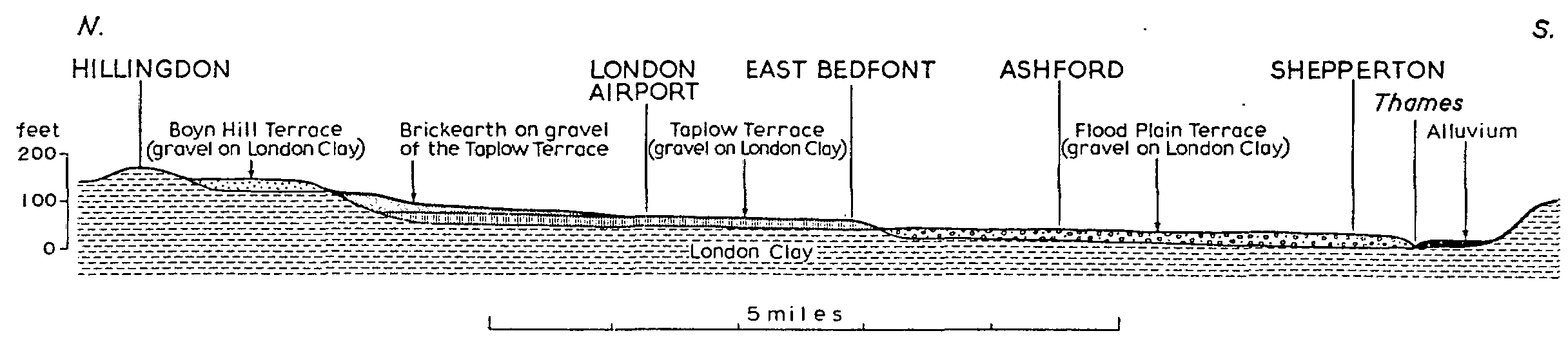
SECTION ALONG GRID MERIDIAN 508
The Middle Terrace (or Middle Terrace Group) is much more extensively preserved. Between Hayes and Hampton the Taplow Gravel plain, surfaced by brickearth in its northern part, is seven miles wide. It narrows eastward to Ealing. Its continuity is broken north of Chiswick by an embayment of low ground, but the terrace is resumed east of Holland Park and continues thence to the brink of the Lea valley at Clapton and Old Ford. It forms the low, gravel-capped plateaux which provide the sites of the City of London and the 'West End'.
The Low Terrace forms a wide lower plain between Staines and Hampton and again further east on the north side of the river as far as Brentford, beyond which it forms a wide expanse around Walham Green and Chelsea. The bluff marking the rearward edge of the terrace is a distinctly traceable feature in the topography of London, running from Holland Park past the Albert Hall to Knightsbridge, across the Green Park and along Jermyn Street to the river-bank at Charing Cross.
The main terraces of the Thames are duly represented in its chief tributary valleys. In the Brent valley the High Terrace survives in outlying patches on the north bank, both north and south of Wembley, while the river from the 'Welsh Harp' to near Perivale is bordered by gravels of the Taplow stage. In the Lea valley the High Terrace is represented by outliers near Wood Green, Palmers Green, and Bush Hill Park. The Taplow gravels with overlying brickearth form the western part of the valley floor from Tottenham northward, succeeded by the Flood Plain Gravels along a line close to the High Road through Tottenham.
The Terrace drifts taken as a whole are important in the history of our region in two distinct ways. The deposits themselves contain the earliest evidence of man in the area, in the form of Palaeolithic flint implements. Secondly, where they are present, the deposits completely transform the surface and sub-surface geology of the area. The most significant geographical line within the county is the northern edge of the terrace drifts from Uxbridge to Stamford Hill. Southward is the wide drift-floored plain, and northward the hilly country of the London Clay where the drift is confined to the hill-çappings.
The general succession of terraces evidently records the periodic deepening of the valley, but to treat the terraces simply as abandoned flood plains implies too simple a picture of the physical history of the deposits. The Boyn Hill Terrace is younger than part at least of the Chalky Boulder Clay since it rests upon it in western Essex. Later times witnessed the return of arctic conditions on at least two occasions. The deposits thus overlap in time with the later stages of the Ice Age and cover a period of marked change of both climate and sea-level. The glacial episodes were times of low sea-level, since the widely spreading land ice represented water withheld from the oceans. Intervening warmer (interglacial) periods were marked by high sea-levels. The base-level controlling the flow and erosion of the river has thus been subject both to downward and upward movements. The former mark phases of erosion, or valley deepening, while the latter caused the building up of the thick gravel sheets.
The full record of the complicated changes thus caused cannot be reconstructed from evidence within the county, but, by calling in evidence the terrace deposits of Kent and Essex, the following sequence has been made out. The earliest deposits of the Boyn Hill Terrace (the 'Lower Gravels' at Swanscombe) were accumulated following a phase of planation which formed the rock 'floor' on which they rest at about 70 ft. O.D. The fossils found here indicate a temperate climate. There then ensued a depression of the base in a fall of sea-level and the erosion of a deep channel of which the floor stands at 20 ft. O.D. near Swanscombe and below sea-level at Clacton. In the following phase the channel was filled as the sea-level rose and the deposits finally extended beyond its lip so as to rest upon the Lower Gravel at Swanscombe. At this time, therefore, the flood plain rose higher than in the early Boyn Hill phase and the equivalent sea-level is estimated to have stood at about 100 ft. O.D. It is particularly to be noted that the acceptance of this pronounced phase of gravel-accumulation implies that lower-lying deposits may be older than those at higher levels. Thus gravels and brickearths at Stoke Newington which occur at what would normally be considered the 'Taplow' level are, in fact, assigned to a stage of the Boyn Hill gravel accumulation.
This great oscillation of sea-level, involving the cutting and subsequent filling of a deep channel, indicates the pattern of later events. The succeeding fall of base-level led to a renewed deepening of the valley to below its present floor, uncovering the Boyn Hill ledge, with its composite covering of deposits, as a terrace, but locally sparing the lower part of the infilling of the former channel. Upon both these sets of deposits is found superimposed a well-marked layer of chalky sludge (Coombe Rock), the product of soil-creep in a climate of glacial severity.
Further down-cutting followed, in which parts of the sludge-sheet were removed; the succeeding gravel accumulation built up the thick gravel of the Taplow stage by the end of which the sea-level is estimated to have reached about 60 ft. O.D. There followed a widespread phase of brickearth formation reflecting a steppe climate in which windblown dust was accumulated as loess or arrested by marshes or standing water to give water-laid loams (i.e. brickearths).
There is evidence of three further phases of down-cutting followed by gravel accumulation in the succeeding deposits. First was formed the rock-floor of the Upper Flood Plain Terrace: the lower part of the deposits which rest upon it yield clear fossil evidence of an arctic climate and are associated locally with soil-creep gravels which mark the return of 'periglacial' conditions. The ensuing fall of sea-level led to the cutting of another deep channel with its floor in places as much as 100 ft. below O.D. During the cutting of this gorge it is believed that soil-creep gravels continued to descend the valley slopes, but with the return of a warmer climate and a rising sea-level, gravel accumulation was resumed and the channel was filled with gravel to a height above that of the existing alluvial flood plain. The upper surface of the 'fill', where this protrudes above the alluvium, constitutes the 'Lower Flood Plain Terrace'. The alluvium itself attains locally to a thickness of 50 ft., and this has been taken to imply the cutting of still another channel in the earlier gravel 'fill' and its subsequent filling by gravel accumulation.
The deposits classed as Alluvium are the most recent deposits of the Thames and its tributaries and form the low-lying ground immediately bordering the streams. It consists largely of mud but includes local masses of gravel and extensive beds of peat accumulated under marsh conditions before the embanking of the river. The older parts of the alluvium may date from Neolithic times, but an appreciable thickness has accumulated since Roman times. Thus, at Tilbury (Essex), a formerly grass-grown surface covered with Roman refuse (tiles, pottery, etc.) lay 8 ft. below the present ground surface. As late as the 2nd century the areas of alluvium were probably submerged at high tide and it may well have been possible for the earlier Anglo-Saxon invaders to avoid the ruins of Roman London by passing directly by boat from Limehouse reach to Lambeth reach.
THE CONDITIONS OF SETTLEMENT
Having outlined the geological constitution of the area and the nature and origin of its present surface, we may now characterize its qualities as a human environment. Two main considerations must guide our attempts to reconstruct physique and settlement conditions in the earlier stages of settlement; first the nature of the vegetation cover and the distribution of arable soils, and, secondly, water supply. In the first stage of the inquiry we can call to our aid the findings of plant ecology and pedology. The most salient feature of the area during the earlier stages of human occupancy was its widespread forest cover. In the wider region of which the area forms part, the deciduous forest of western and central Europe reached its fullest and most typical British development. The principal trees were oak and beech, often growing together, but with the oak predominant on the clay lands, and the beech on drier soils. The oak woods themselves are of two main types, one on the heavier clays dominated by the common oak (Quercus robur) and the other on the drier sands or gravels dominated by the Sessile or Durmast oak (Q. petræa). (fn. 5) The commonest shrub of the undergrowth is hazel but this is replaced by hornbeam over much of the Middlesex area.
Epping Forest, a little beyond the eastern boundary of the county, preserves excellent examples of both the wetter and the drier types of woodland and Defoe correctly inferred that here we may see 'what the face of this island was before the Romans' time'. (fn. 6) On the lower slopes of the forest ridge and notably on the flat land between Chingford and High Beech characteristic 'wet oak-wood' is seen to advantage but from High Beech northward to Epping the beech associated with the 'dry oak', hornbeam, and birch become dominant, giving woodlands of much more open type, with subordinate undergrowth.
Following the initiative of such writers as O. G. S. Crawford, Sir Mortimer Wheeler, and Sir Cyril Fox, recent years have seen many studies which purport to reconstruct original vegetation in base maps showing archaeological distribution. These studies have tended to a simplification and over-emphasis in equating clay-country almost alone with forest land. For this mistake the traverse of Epping Forest alone provides a correction. No part of Middlesex can have been free from forest growth. Even the lighter soils bear well-grown trees today, as may be seen on the lower slopes of Hampstead Heath and on Stanmore Common. That these lighter soil areas retain little extensive woodland today is probably due to the fact that they bore more open and more easily cleared woodland and were more inviting to the plough. By contrast the heavier clay soils were a morass in winter but without surface water in summer. It is important to notice that it is not in fertility that the heavier soils are lacking, since they are actually richer in plant-foods, but in their suitability for ploughing. Only in our own day, with rapid mechanical ploughing which can choose its time and season, has the heavy 'wheat and beans land' of Middlesex become profitably available for cereal farming. The sharpest physical contrast within the county, in fact, is that between the heavy clay country and the wholly or partly drift-covered areas of lighter soil. The brickearth and valley-gravel soils of western Middlesex were, and are, eminently arable. When to such attractions for cultivation is added the further decisive factor of the availability of water, the contrast as human habitats between the claylands and the gravel lands becomes unarguably evident. Middlesex is without the chalk downland soils in which so much pre-historic settlement took place in southern Britain, but it could offer an equal if not superior substitute. Physical and historical geography combine to indicate that the only really significant 'regional boundary' in Middlesex is the boundary of the Thames valley drifts, continued perhaps in that of the Lea valley drifts in the east of the county. If we seek a valid regional division of the northern parts of the county it can best be taken at or near the line of Watling Street. Westward lies the London Clay plain diversified by scattered island hills of which Harrow is typical. Eastward lie the heights of Hampstead with their water-bearing, sandy cap-rocks and the gravelcovered plateaux of Hendon, Southgate, and Enfield. The contrast can be seen well in the westward view from the Mill Hill ridge. Within this eastern area the soil conditions are less favourable than in the great Thames-side plain. The valley slopes are in London Clay and must have been heavily forested and the older settlement pattern emphasizes hill-top sites, essentially perhaps 'dry-point sites' but always within reach of water at shallow depth and of local tracts of light and easily-ploughed soil. In such terms patterns can be descried even amidst the built-up areas of northern suburban London.
The chief, although not the only way in which the ground it rests on influences the life of the modern county, is in respect of water supply; and the history of London's water supply is an important strand in the general history of the area. The first supplies were no doubt from the brooks and rivers, supplemented by springs and shallow wells tapping the considerable water-body held in the river gravels. In this connexion we may briefly describe the family of minor streams that drains the Hampstead ridge and its continuations to the Thames. From west to east are the Little Ealing Brook, joining the Thames east of Brentford; Stamford Brook flowing through Acton Vale to the Thames at Hammersmith Bridge; and Bridge or Counter's Creek, passing Addison Road Station and Walham Green and joining the Thames at Sands End. Three larger streams drain the riverward slope from Hampstead: the West Bourne, the Tyburn, and the Holborn or Fleet River. The first descends past Kilburn to Bayswater. The Tyburn rises north of Belsize Park and flows thence through Regents Park and Marylebone to near Buckingham Palace, joining the Thames near Vauxhall Bridge. The Fleet rises between Hampstead and Highgate and its two branches traverse the valleys now occupied by the Hampstead and Highgate ponds. The two branches joined near Camden Town and continued past St. Pancras church and Battle Bridge (King's Cross). Beyond, the valley is marked by the line of Farringdon Street and New Bridge Street, Holborn Viaduct marking the head of the short but navigable estuary. Above this point the stream was known as River of Wells or Turnmill Brook, recalling its importance as a source both of spring water from the gravel base on the valley sides and of water power. Lastly, the Walbrook rose in the marshy area of Moorfields and flowed past the Bank and Mansion House to a mouth at Dowgate, which like the mouth of the Fleet served as one of London's early ports.
Although most of these streams are now diverted into sewers, they have left a clear mark on the place-names of London and several of them were utilized for water supply. Immediate local supplies became inadequate in the 13th century when a conduit system was first introduced carrying water from gravel springs in the Tyburn valley (at Stratford Place, Oxford St.). (fn. 7) Similar conduits brought water from Paddington and Hackney. (fn. 8)
The Thames was laid under direct contribution in 1582, and more distant sources were first tapped by the New River (1613) which brought water from chalk springs in the Lea valley at Amwell and Chadwell (Herts.) to New River Head, significantly sited where the high ground of the Boyn Hill Terrace overlooks the City of London. (fn. 9) Since the geological structure of the area ensures a reservoir of underground water in the Chalk, constantly replenished by the rainfall on the bordering chalk hills, it might seem that this supply could be the main resource of latter-day and modern London. Although it is in fact laid under contribution (notably in south-east London) and there are many privately owned wells, 60 per cent. of present public supplies is in fact drawn from the Thames through the great storage reservoirs, notably near Staines and Sunbury, while similar reservoirs mark the floor of the lower Lea valley at Chingford and Walthamstow. In 1960 a large underground tunnel to convey water from Hampton to Chingford was completed, thus accentuating the predominance of the Thames.