A History of the County of Middlesex: Volume 4, Harmondsworth, Hayes, Norwood With Southall, Hillingdon With Uxbridge, Ickenham, Northolt, Perivale, Ruislip, Edgware, Harrow With Pinner. Originally published by Victoria County History, London, 1971.
This free content was digitised by double rekeying. All rights reserved.
'Norwood, including Southall: Local government', in A History of the County of Middlesex: Volume 4, Harmondsworth, Hayes, Norwood With Southall, Hillingdon With Uxbridge, Ickenham, Northolt, Perivale, Ruislip, Edgware, Harrow With Pinner, (London, 1971) pp. 49-50. British History Online https://www.british-history.ac.uk/vch/middx/vol4/pp49-50 [accessed 23 April 2024]
LOCAL GOVERNMENT.
A Norwood tithing was amerced by the justices in 1235. (fn. 1) According to Lysons courts for Norwood manor were held at the latest from 1481, (fn. 2) but even if this was the case the manor was clearly subordinate to that of Hayes. (fn. 3)
There seems to have been an independent vestry in Norwood by the mid 17th century, as at this date the poor-rate was levied not only on Norwood, Southall, and Northcott, but also on people residing in Heston, Hanwell, Greenford, and 'other out towns'. (fn. 4) The vestry, however, was not expressly mentioned until 1720. (fn. 5) In 1642 Norwood had two overseers, two constables, and a churchwarden, (fn. 6) but little is known of the local administration until the 19th century. In the late 18th century the poor-rates increased steadily from £252 in 1777 to £417 in 1785. (fn. 7) They reached a peak of £850 in 1821. (fn. 8) The parish had acquired a workhouse by 1803 when it had 12 inmates. (fn. 9) In 1814 the workhouse stood on the north side of what is now Featherstone Road. (fn. 10) There were 8 inmates in 1834, (fn. 11) but Norwood was included in the Uxbridge Union of 1836 and the workhouse poor were transferred to the union workhouse at Hillingdon. The Norwood vestry always remained an open one. (fn. 12) A vestry clerk was first appointed in 1857 because the population had then reached over 2,000. (fn. 13)
For the next thirty years little is known of the work of the vestry, which was probably not very active. A school board was formed in 1877, (fn. 14) and in 1877 and 1878 plans for water- and gas-works were being put into effect. (fn. 15) A Local Government Board order made in 1878 instructed the parish to find a permanent room for the vestry meetings. (fn. 16) In 1882 the first drainage proposals were introduced by the rural sanitary authority, but only for the area south of Norwood Green, (fn. 17) and in 1883 an Act for providing Norwood with mains water was passed. (fn. 18) By 1890 a complete drainage system for Norwood had been carried out and in the same year the parish applied to be created an urban district. At the ensuing inquiry it was found that since 1871 the rateable value of the parish had almost doubled from £22,000 to nearly £41,000, and that more than half of the latter figure was assessed on only 4 properties: the G.W.R. Co.'s line, the Grand Junction Canal, the Brentford Gas Works, and the Hanwell asylum. In addition to the rural sanitary authority and the lighting inspectors, there were 7 other parish bodies: the vestry, the guardians, the overseers, the assessment committee, and the highway, school, and burial boards. The vestry felt that all these bodies needed co-ordinating, and also that the inspector of nuisances and medical officer of health ought to reside in the parish, as much of their work was within it. The burial board was certainly in existence by 1883. The highway board had 11 members and was responsible for the whole parish; there were about 13 miles of road, of which over 2 miles of Uxbridge Road were repaired by the county. The jurisdiction of the lighting committee did not extend over the whole parish, and to light the remainder would require a second committee. (fn. 19)
The Southall-Norwood U.D.C. was set up in 1894 with 14 members and 6 officers: a clerk, treasurer, surveyor, sanitary inspector, medical officer of health, and tax collector. (fn. 20) The council offices in the High Street were built in 1897-8. (fn. 21) The council proposed to build an isolation hospital in 1900, (fn. 22) and in 1904 the sanatorium on North Road, Mount Pleasant, was opened. (fn. 23) This later became the Mount Pleasant Hospital. In 1905 the electric lighting orders were confirmed, (fn. 24) and in the same year the public library in Osterley Park Road was opened. (fn. 25) By 1906 the council was meeting twice a month. It acquired some land in 1906 on which to erect a mortuary, (fn. 26) and in 1908 about 14 a. were acquired by the council from Lord Jersey as a recreation ground; (fn. 27) in 1924 there were three public open spaces: Southall Park (26 a.), the Recreation Ground (15 a.), and Norwood Green (8 a.). (fn. 28) The Recreation Ground, reached from Recreation Road or Tachbrook Road, lies in the ancient parish of Heston, but the area of the urban district and the Norwood civil parish had been extended in 1894 to cover the small part of Heston north of the canal. (fn. 29)
An open-air swimming pool was built there in 1913 and reconstructed in 1930. (fn. 30) In 1924 the number of councillors was increased to eighteen. In 1925 the Southall-Norwood Hospital was first proposed and in 1930 a site on Uxbridge Road, behind Holy Trinity Church, was chosen. This site was later sold, and the hospital was opened in 1935 on its present site at the corner of the Green and Osterley Park Road. (fn. 31)
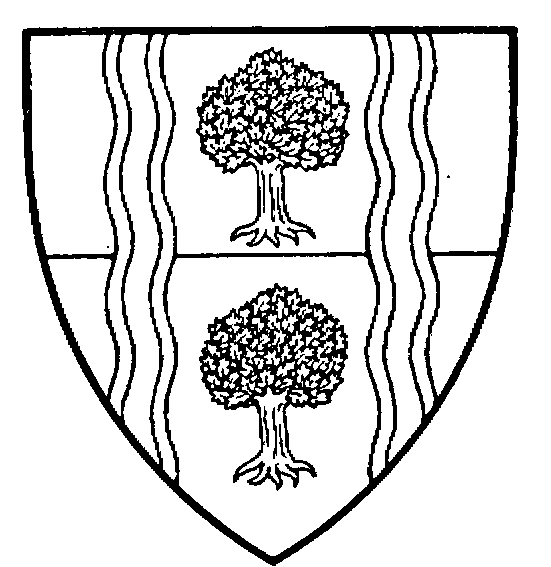
Borough of Southall
Parted fesswise or and vert, two thorn-trees, the upper one proper and the lower or, between two palets wavy argent each charged with another such palet azure [Granted 1936]
In 1936 the municipal borough of Southall was formed, its area of jurisdiction being the same as the old urban district and the ancient parish of Norwood, the only civil parish being that of Norwood. (fn. 32) The borough council consisted of 18 members elected from 6 wards; (fn. 33) by 1960 membership had increased to 24, consisting of 6 aldermen and 18 councillors. (fn. 34) In 1965 Southall Borough was merged with the boroughs of Ealing and Acton to form the new London Borough of Ealing. (fn. 35)