A History of the County of Middlesex: Volume 4, Harmondsworth, Hayes, Norwood With Southall, Hillingdon With Uxbridge, Ickenham, Northolt, Perivale, Ruislip, Edgware, Harrow With Pinner. Originally published by Victoria County History, London, 1971.
This free content was digitised by double rekeying. All rights reserved.
Diane K Bolton, H P F King, Gillian Wyld, D C Yaxley, 'Hillingdon, including Uxbridge: Introduction', in A History of the County of Middlesex: Volume 4, Harmondsworth, Hayes, Norwood With Southall, Hillingdon With Uxbridge, Ickenham, Northolt, Perivale, Ruislip, Edgware, Harrow With Pinner, ed. T F T Baker, J S Cockburn, R B Pugh (London, 1971), British History Online https://www.british-history.ac.uk/vch/middx/vol4/pp55-69 [accessed 2 May 2025].
Diane K Bolton, H P F King, Gillian Wyld, D C Yaxley, 'Hillingdon, including Uxbridge: Introduction', in A History of the County of Middlesex: Volume 4, Harmondsworth, Hayes, Norwood With Southall, Hillingdon With Uxbridge, Ickenham, Northolt, Perivale, Ruislip, Edgware, Harrow With Pinner. Edited by T F T Baker, J S Cockburn, R B Pugh (London, 1971), British History Online, accessed May 2, 2025, https://www.british-history.ac.uk/vch/middx/vol4/pp55-69.
Diane K Bolton, H P F King, Gillian Wyld, D C Yaxley. "Hillingdon, including Uxbridge: Introduction". A History of the County of Middlesex: Volume 4, Harmondsworth, Hayes, Norwood With Southall, Hillingdon With Uxbridge, Ickenham, Northolt, Perivale, Ruislip, Edgware, Harrow With Pinner. Ed. T F T Baker, J S Cockburn, R B Pugh (London, 1971), British History Online. Web. 2 May 2025. https://www.british-history.ac.uk/vch/middx/vol4/pp55-69.
In this section
HILLINGDON INCLUDING UXBRIDGE
Hillingdon ancient parish lay on the north-west border of Middlesex approximately 16 miles from Charing Cross, 12 miles from Watford (Herts.), and 7 miles from Windsor. (fn. 1) In shape an irregular rectangle, the old parish measured approximately 3 miles at its broadest point and, except where small rectangular areas projected from the north-west and south-east corners, roughly 5 miles from north to south. (fn. 2) The River Colne formed the county boundary with Buckinghamshire and the western parish boundary except in the extreme north-west where for about a mile both boundaries followed the Shire Ditch, a feeder of the Colne running between the parent stream and the Frays River or Cowley Stream, a branch of the Colne flowing parallel to and between ¼ and ½ mile east of the main stream. The other three sides were bounded by the parishes of Harefield and Ickenham (fn. 3) on the north, Hayes and Harlington to the east, and West Drayton and Harmondsworth to the south. Along the LondonOxford road (Uxbridge or London Road) south-east of the bridges carrying the highway over the Frays and Colne streams lay the hamlet and market-town of Uxbridge, whose inhabitants, relying on the town's tenuous claim to borough status, exercised an ill-defined franchise over an uncertain area of between 80 and 100 a. situated north of the modern Vine Street and mainly east of the Frays River. Until the 19th century the township was separated from Hillingdon by a 'borough ditch'. (fn. 4) South of Uxbridge, between the Frays stream on the west and the River Pinn to the east, lay Cowley parish, a fragmented 300-acre area entirely surrounded by and partly intermixed with Hillingdon. (fn. 5) Also insulated in Hillingdon, about 200 yards south of the junction of Swakeleys Drive and Long Lane, lay Chestlands, a 6-acre field belonging to Ickenham parish, while south-east of Ickenham village was a detached area of 12 a. belonging to Hillingdon. In 1841 (fn. 6) Hillingdon parish, including the 99-acre 'chapelry' or township of Uxbridge, contained 4,944 a. and Cowley parish 306 a.
From medieval times Hillingdon, Uxbridge, and Cowley were for many purposes so closely related that it is almost impossible to consider them apart. Uxbridge and, later, the Domesday manor of Hillingdon were included in Colham manor; (fn. 7) from an early date Uxbridge hamlet extended into Hillingdon parish; parts of Cowley village lay until 1895 in Hillingdon. (fn. 8) Throughout the Middle Ages Uxbridge, jealously guarding its supposed privileges, maintained an uneasy administrative relationship with manor and parish authorities. (fn. 9) From the 17th century onwards, however, the economic growth of the hamlet gradually transcended the traditional framework of its parent parish. By 1830 the economic and administrative importance of Uxbridge had almost totally eclipsed that of Hillingdon parish and the town was virtually autonomous. This reversal in the administrative roles of hamlet and parish was recognized in the formation in 1836 of the Uxbridge Poor Law Union which comprised nine west Middlesex parishes including Hillingdon and Cowley. (fn. 10) The western portion of Hillingdon and the four northernmost detached parts of Cowley were included in the Uxbridge Local Board of Health District, constituted provisionally in 1849 and confirmed in 1853. (fn. 11) Under the Divided Parishes Act of 1882 the eight detached parts of Hillingdon and Ickenham were allotted to the parishes in which they were geographically situated. (fn. 12) In 1894 the Uxbridge Local Board of Health was replaced by an urban district council. Hillingdon old parish was then divided, the part within the new Uxbridge U.D. becoming the civil parish of Hillingdon West and the remainder Hillingdon East. In 1896 nearly 900 a. on the southern border of the old parish were separated from Hillingdon East to form the civil parish of Yiewsley. (fn. 13) At the same time the part of Hillingdon East west of the Pinn was transferred to Cowley parish and the part of Cowley east of the Pinn to Hillingdon. (fn. 14) Yiewsley became an urban district in 1911 and in 1929, after boundary changes involving the transfer of 193 a. from Hillingdon East and 33 a. of Cowley to Yiewsley and the addition of 29 a. of Yiewsley to Cowley, was joined with West Drayton and Harmondsworth civil parishes to form Yiewsley and West Drayton U.D. (fn. 15) By the same order Uxbridge U.D. was extended to include the whole of the revised civil parishes of Hillingdon East (2,762 a.), Cowley (521 a.), and Harefield (4,622 a.). (fn. 16) In 1937 Uxbridge civil parish, co-extensive with the 10,240-acre urban district, was formed, and in 1955 the former urban district became the Borough of Uxbridge. 'Hillingdon' reappeared as the name of a major administrative unit in 1965 when the municipal borough of Uxbridge was merged with the urban districts of Hayes and Harlington, Ruislip- Northwood, and Yiewsley and West Drayton to form the new London Borough of Hillingdon. (fn. 17)
From at least as early as the 17th century the external boundary of Hillingdon parish was also, for most of its length, that of Colham manor. The only extant pre-19th-century survey, made in 1636, (fn. 18) traces the boundary from the Oxford road at Frays Bridge northward along the Shire Ditch, the Colne, and minor feeders of the Frays stream (fn. 19) to the southern edge of Cow Moor in Harefield, to Gospel Hill on the Harefield road, and along the edge of Swakeleys Park to Ickenham Bridge over the Pinn. Here the manor and parish boundaries separated. Nineteenth-century plans (fn. 20) show the parish boundary continuing eastward along the line of the modern Swakeleys Drive and just south of Ickenham Manor Farm to the Yeading Brook. After leaving this stream at its junction with a westward extension of Sweetcroft Lane the boundary passed across fields to Pole Hill Farm, where it rejoined the manor boundary, and then almost due south over Hillingdon Heath to the London road. South of the road the manor and parish boundary continued southward, passing east of the hamlet of Goulds Green, to Portway or Porter's Lane which ran east from Drayton towards Dawley. South of Portway Lane lay Hide Field, an almost detached 42-acre field protruding southward between Drayton and Harlington parishes. From the north-west corner of Hide Field the boundary ran along Portway Lane and northward up Falling Lane until it turned north-west to Colham manor-house. South of the house the boundary again ran south-westward to the Colne at its junction with the Colham mill stream. In 1636, as later, the Colne formed the western boundary of county, parish, and manor. Parts of the eastern boundary and, of course, the western boundary were perpetuated as the boundaries of Uxbridge Borough, but the remainder was completely obscured in the administrative reorganizations which began in 1896. (fn. 21)
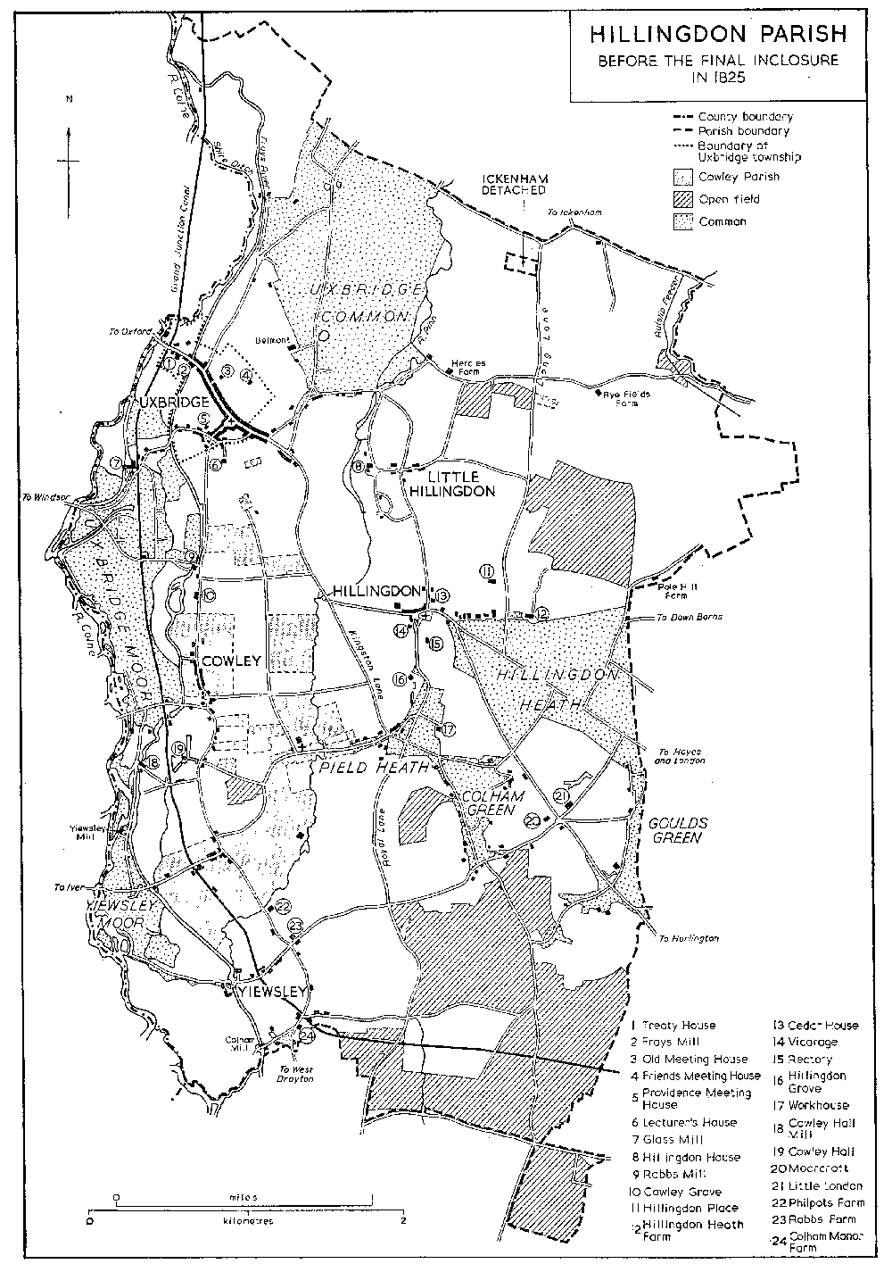
HILLINGDON PARISH Before the final inclosure in 1825
Until natural divisions were blurred by modern housing this area was divisible into two distinct topographical zones, reflecting its underlying geological structure and lying north and south of the London-Oxford road, a medieval highway which crosses the parish in a north-westerly direction, passing through Hillingdon village and entering Buckinghamshire at Uxbridge. North of the road is an area of undulating clay country (fn. 22) at between 100 and 200 ft. Heavily wooded well into historic times, (fn. 23) this part of the parish remained largely uninhabited and partly uncultivated until the 20th century. Between Hillingdon village and Uxbridge a narrow tongue of clay extends southward as far as Cowley along the valley of the Pinn, a drainage stream flowing south-westward across the parish through Swakeleys lake in Ickenham to the Frays stream at Yiewsley. South of the London road the land falls uniformly to a south-draining plain at about 100 ft., the soil of which is almost entirely fertile brickearth overlying, to a depth of between 18 in. and 5 ft., valley gravels resting on a subsoil of London blue clay. (fn. 24) In this area lay most of the medieval open fields, the manor-houses, and many of the later principal residences. (fn. 25)
Archaeological evidence suggests that early settlement was largely confined to the well-drained lighter soils and concentrated at Hillingdon and around Colham and Yiewsley in the extreme south-west. Hillingdon, occupying a commanding position on a patch of glacial gravels at about 190 ft., has yielded evidence of Palaeolithic occupation. Similar remains have been recovered from the underlying gravels at Yiewsley, (fn. 26) and the discovery there, in Boyer's gravel-pit, of large quantities of Bronze or early Iron Age pottery suggests domestic occupation in the south of the parish by the early Iron Age. (fn. 27) Theories of Roman settlement in the area have been overstated, but at least one Roman road is thought to run through the parish from north to south. (fn. 28) Fragments of Roman ware have been found at Uxbridge, near Cowley church, (fn. 29) and, more recently, on the site of an unidentified earthwork at Coney Green, Hillingdon. (fn. 30) The incorporation of Saxon personal names in the place-names 'Hillingdon', 'Colham', 'Cowley', and 'Yiewsley', (fn. 31) and the probable association of Uxbridge with the 7th-century Wixan tribe (fn. 32) suggest areas of Saxon settlement. Attempts to interpret early forms of the place-name 'Uxbridge' as indicating the existence of a Saxon borough are inconclusive, and more reliable authorities suggest that the hamlet's name derives from its position at the eastern end of a ford and later bridge across the Colne. (fn. 33)
Development Before 1800.
The first certain indications of the topography of the area appear in the Domesday Survey. (fn. 34) In 1086 the most prominent natural feature was an extensive tract of woodland, the bulk of which, probably confined to the heavy clays to the north, lay in Hillingdon manor. (fn. 35) Settlement seems to have been concentrated in hamlets at Hillingdon and Colham: the Survey mentions 33 persons in Colham manor and 10 in Hillingdon. Uxbridge is not included by name in the Survey although it was almost certainly in existence by 1086. When first mentioned in the 12th century it was already an important settlement. (fn. 36) A chapel of ease was built in the town in the early 13th century, (fn. 37) and in 1275 Uxbridge was one of the two Middlesex townships represented in Edward I's first parliament. (fn. 38) The vills of Colham and Uxbridge are mentioned in 1316. (fn. 39) In 1328, and probably earlier, separate courts were being held for the hamlet of Uxbridge, (fn. 40) and by the end of the 14th century Uxbridge, following the apparent decline of the hamlet at Colham, (fn. 41) had become the major settlement.
Early-14th-century surveys suggest that manorial demesne in the parish was divided almost equally between arable and pasture with smaller scattered areas of woodland. (fn. 42) The nature of the 'old park' which contained 200 a. of pasture in 1328 (fn. 43) is unknown; it probably lay north of Hillingdon Heath in an area which was called Old Park as late as 1636. (fn. 44) Eight acres of woodland enclosed in 1328 by a ditch may be identifiable with the later Coney Green which was shown as a rabbit warren in 1675 (fn. 45) and as completely surrounded by a low earthwork in 1733. (fn. 46) As early as 1311 (fn. 47) the lord of Colham owned another warren on what later became known as Uxbridge Common. (fn. 48) During the 14th century, and presumably earlier, the lords of Colham also held more than 300 a. in Whatworth Field and Hanger Field and an unspecified acreage in Strode Field, Brodeappledore Field, Stone Field, and Rye Hill Field. (fn. 49) The exact location of the medieval open fields is uncertain, but most of them probably lay, as did the later common fields, south of the London road and east of the Frays stream. Only two medieval fieldnames, Rye Hill Field and Alton Field, survived into the 17th century. In 1777 Rye Hill Field apparently lay south of Rye Fields Farm in the triangle formed by Long Lane and Sweetcroft Lane. (fn. 50) Abutting Rye Hill Field to the south was High Field, said in the late 17th century to contain 67 a. (fn. 51) Hillingdon Field and Little Hillingdon Field possibly lay near the two settlements, but other fields mentioned in the 17th and 18th centuries all lay south of the London road. (fn. 52) South of the modern West Drayton Road were Hale Field, Beadle, Bedwell, or Bedewell Field, and Upper Field, a large field extending southward to the almost-detached Hide Field. (fn. 53) Between Upper Field and Falling Lane to the west was a small field known variously as Harlton, Horton, or Alton Field. Immediately to the north lay Hedging Field, separated by Falling Lane from Royal Field which covered the area between Colham Green and Royal Lane. The bulk of Colham, later Patcott or Padcot, Field probably lay north of Colham manor-house, although its exact limits are uncertain. Stretching northward from Cowley church almost to Uxbridge and bounded by Kingston Lane and Cowley Road to the east and west were more than 300 a. of open-field land known as Cowley Field. Approximately one-third of this, chiefly on the west bank of the Pinn, belonged, in the 18th century and presumably earlier, to the manor and parish of Cowley; (fn. 54) the rest belonged to the manors of Colham and Cowley Hall.
On the clay and gravels to the north and west of the open-field area were extensive tracts of common and waste. In 1636 these were said to comprise about 360 a., (fn. 55) but more reliable 18th-century estimates give their area as almost 600 a. (fn. 56) Northolt or Uxbridge Common, which extended into Harefield parish in the north-west, and Hillingdon Heath, straddling the London road east of Hillingdon village, each contained about 200 a. West of the Frays stream were Uxbridge or Hog Moor (100 a.) south of the town and Yiewsley or Colham Moor (60 a.) stretching north of Yiewsley along the Middlesex bank of the Colne. Pield or Peel Heath north-west of Colham Green covered about 15 a., and Goulds Green, a southward extension of Hillingdon Heath, about 20 a.
By the time of the first parliamentary inclosure in 1795 (fn. 57) approximately three-fifths of Hillingdon parish had already been inclosed. (fn. 58) Inclosure of small parcels of waste probably proceeded steadily from the late medieval period onwards: some open-field land had been inclosed before 1636, and the process accelerated during the 17th and 18th centuries. (fn. 59) Under the 1795 Act Cowley Field, comprising 331 a. in Hillingdon and Cowley parishes, was inclosed. (fn. 60) A second Act, passed in 1812 and executed in 1825, inclosed a further 1,400 a. and completed the inclosure of open-field and waste land, save for 15 a. of Uxbridge Common which were reserved as an open space. (fn. 61)
Until the construction at the end of the 18th century of the Grand Junction Canal the appearance of the parish remained substantially unchanged. Modifications were limited to the development, apparent from the 14th century onwards, of a simple pattern of internal communications. As a result of the natural barrier formed by the Colne and its tributary streams most of the major roads within the parish ran, until comparatively recent times, from north to south linking scattered settlement areas to the Oxford road, which crossed the river at High Bridge north-west of Uxbridge, or to the Bath Road in Harmondsworth parish to the south. (fn. 62) The London- Oxford road was an important national route by the 14th century. In 1358 Ellis Waleys of Uxbridge and two Acton men were granted rights of pavage in Uxbridge, Acton, and elsewhere between the two towns. (fn. 63) High Bridge was said to be ruinous in 1377, (fn. 64) and Stratford Bridge, carrying the Oxford road across the Pinn between Hillingdon and Uxbridge, was in existence by 1410. (fn. 65) A highway from Uxbridge to Rickmansworth is mentioned in 1384. (fn. 66) Contemporary navigation of the Colne as far as Uxbridge is suggested by the construction in 1419 of a wharf serving Mede mill. (fn. 67) By 1636 (fn. 68) the river had been bridged at a further three places between High Bridge and Yiewsley. The Uxbridge-Windsor road crossed the Colne at another High Bridge (later Long Bridge) south-west of the town. Further south were Rowley (later Cowley Moor) Bridge on the road from Cowley to Potters Cross, and Marsh or Huntsmoor Bridge on the road from Cowley to Iver. Responsibility for repairs to these three bridges was shared equally between the lords of Colham and Iver manor in Buckinghamshire. High Bridge on the London road was rebuilt as a seven-arch brick bridge about 1768 and Stratford Bridge as a brick bridge of three arches before 1726. (fn. 69) Although Long Bridge and Cowley Moor Bridge were both rebuilt before 1814 and all four Colne bridges improved or again rebuilt several times in the next one hundred and fifty years, there were still only four major bridges across the main river in 1964. Frays (later Mercer's) Bridge, carrying Uxbridge High Street across the Frays stream, was in existence by 1636. (fn. 70) It is shown on a plan of 1675 (fn. 71) as a brick bridge with three arches. South-west of the town the road to Potters Cross crossed the Frays stream at Moorfield (later Rockingham) Bridge, (fn. 72) built before 1675 (fn. 73) and rebuilt as a brick bridge of three arches in 1809. (fn. 74) By 1675 roads entering the parish by the Colne bridges were linked to Uxbridge and with West Drayton and Harmondsworth in the south by Cowley Road which ran south from Uxbridge roughly parallel to the Frays stream. (fn. 75) Other important 17th-century routes in the south of the parish were Royal Lane leading from Hillingdon through West Drayton to Harmondsworth, and Dawley Lane (later Harlington Road) running south-east from Hillingdon village towards Dawley and Cranford. (fn. 76) These three major north-south roads were joined by a network of lanes and access ways, chief of which were Falling or Fulling (later Kingston) Lane running from Stratford Bridge to Colham Green, Porter's or Portway Lane following the Drayton parish boundary towards Dawley, and lanes linking Goulds Green, Colham Green, and Hillingdon in the east, and Yiewsley with West Drayton in the south-west. North of the London road there were, until the 20th century, only two major roads: the road to Harefield (later Park Road) which joined the London road at the east end of Uxbridge, and Long Lane running south from Ruislip and Ickenham to the London road east of Hillingdon village. Between these Vine Lane, which ran north from Hillingdon church, may also have been of some importance. Pages or Peazes Lane left the Harefield road on Uxbridge Common and entered Uxbridge at the west end. East of the Pinn a number of minor lanes, including Sweetcroft Lane and Hercies Lane, linked the hamlets of Hillingdon and Little Hillingdon and the scattered farms to the east. Except for the widening and improvement of former minor lanes, this pattern of road communications altered little until the urban developments of the 1930s.
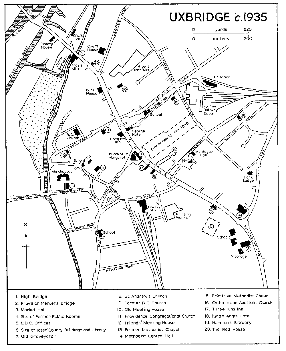
Surveys made in the early 16th century stress the economic importance of Uxbridge. A market-house had apparently been built by 1513, (fn. 77) and an index to the relative prosperity of the town is provided by an assessment of 1522-3 to which 153 persons in Hillingdon parish were taxed, 77 of them from Uxbridge. (fn. 78) Describing Uxbridge in the 1530s, Leland stressed the town's dependence on its markets, fairs, and mills. (fn. 79) By this time Uxbridge seems to have assumed its later basic pattern of a ribbon settlement of timber-framed houses straggling for ½ mile along both sides of the Oxford road from the two wooden bridges carrying the highway over the Frays and Colne streams to its junction with Blind or Woolwind Lane (later Vine Street). Other houses probably lined both sides of the Lynch and Windsor Street for some 200 yards from the plot of waste known as the Lynch Green (fn. 80) to the junction with High Street. In 1555 three heretics from other parts of the country were burned on the Lynch Green, where a memorial was erected 400 years later. (fn. 81) At the intersection of Windsor Street with High Street, forming then, as later, the nucleus of the town, stood the old market-house and St. Margaret's chapel, a 13th-century foundation largely rebuilt in the 15th century. (fn. 82) The medieval chapel and a few surviving domestic buildings of the 15th and early 16th centuries to some extent qualify a description of the town in the 1580s as being 'of modern date'. (fn. 83) Nearly all the existing timber-framed buildings, many of which date from the 17th century, have altered or rebuilt frontages; they include several inns (see below) and one or two groups and individual houses in High Street. Windsor Street has suffered less alteration and retains for its size a larger proportion of such buildings. Two have also survived in Cross Street, overlooking what was formerly Lynch Green. (fn. 84)
The most notable 16th-century house in Uxbridge is the Treaty House, known in 1968 as the Crown and Treaty House Inn, which stands on the south-west side of High Street between the Frays and Colne streams. It is built of brick and the principal front, lying at right angles to the road, has two two-storied bay windows with moulded brick mullions and transoms. There are three chimneystacks with clustered shafts at the rear and a curvilinear gable at the north-east end. The interior retains some original features. The present range is thought to represent little more than a single wing of the 16th-century mansion, (fn. 85) originally the seat of the Bennet family. (fn. 86) In 1645 the house was used for meetings between Royalist and Parliamentary representatives negotiating the abortive 'treaty' of that year; it was then clearly of considerable extent. (fn. 87) A view published in 1789 (fn. 88) shows the building reduced to its present size; it had two curvilinear gables above the bays on its principal front and a two-storied bay window at its north-east end. By the end of the century High Street had been diverted to run immediately past the house which at that time was let out in tenements. (fn. 89) In 1802 an Uxbridge sculptor, John Burgiss, was employed under Sir John Soane on masonry work at the Treaty House, perhaps in connexion with its conversion into an inn. (fn. 90) A watercolour of c. 1810 shows the walls partly faced with stucco; the front gables and the lower story of the end bay window had by then been removed. The view also includes a small octagonal building which may originally have formed part of a detached gatehouse. (fn. 91) By 1816 the house had become the Crown Inn, an earlier 'Crown' near the market having recently been demolished. (fn. 92)
Three surviving inns in High Street-the 'Three Tuns', the 'King's Arms', and the 'George'-incorporate 15th- and 16th-century work. (fn. 93) Two other inns, the 'Leg' and the 'Axe', mentioned in the 15th century, (fn. 94) probably changed their signs during the 17th century: the 'Axe' is last mentioned by name in 1647. (fn. 95) The 'Bull' and the 'Cross Keys' were in existence by 1548. (fn. 96) Other Uxbridge inns mentioned before 1648 include the 'Swan', standing in 1602, (fn. 97) the 'Black Bull' (1603), (fn. 98) the 'Spread Eagle' (1610), (fn. 99) the 'Chequer' (1620), (fn. 100) the 'Saracen's Head', built about 1619, (fn. 101) the 'Eagle and Child' (1632), (fn. 102) the 'Bell' near the market-house, (fn. 103) the 'Crown' and the 'White Horse', all three first mentioned in 1636, (fn. 104) the 'Rose', and the 'Queen's Head'. (fn. 105) A hundred years later there were twenty-nine licensed alehouses in the town. (fn. 106)
By 1664, despite severe visitations of the plague in the early years of the century, (fn. 107) 240 of the 431 houses in Hillingdon parish charged to hearth tax were situated in Uxbridge. (fn. 108) Further growth almost certainly followed the transfer to representatives of the townspeople in 1695 of the profits of Uxbridge manor. (fn. 109) Wooden pipes supplying the town with water from the Colne are said to have been laid in 1701, (fn. 110) and by 1727 twenty cottages, probably used as almshouses, had been erected in the Lynch. (fn. 111) In the 1730s, and probably earlier, (fn. 112) the main street extended south-eastward beyond Vine Street and the confines of the old borough ditch to form the contiguous district known as Hillingdon or Town End. (fn. 113) By 1782 there were said to be 366 houses within the borough ditch with a population of 1,712, (fn. 114) and the cramped and insanitary nature of High Street was causing inconvenience and concern. (fn. 115) Three years later the manorial trustees secured an Act (fn. 116) authorizing them to widen and improve High Street by demolishing the markethouse and other buildings and by altering the course of the road between Mercer's Bridge over the Frays stream and High Bridge. A new market-house was completed in 1789 (fn. 117) on a site slightly west of the old building. High Street was diverted at the west end of Mercer's Bridge to follow a new line about 52 yds. south-west of the old road, thus running immediately below the north-east gable-end of the Treaty House. (fn. 118) Provision was also made in the Act, which was reinforced by a second Act passed in 1806, (fn. 119) for the regulation of protruding signs, spouts, and steps, and for paving, lighting, and cleaning the streets. (fn. 120)
A panorama of Uxbridge High Street, probably drawn about 1790, (fn. 121) shows that it was then a neat road lined on both sides with Georgian frontages and a few shops. (fn. 122) The only significant non-domestic buildings shown are a chair factory at Hillingdon End, the recently completed market-house near the centre of the street, and a malthouse, a brewery, Mercer's (formerly Frays) mill, and Higgenson's bank, all at the north-west end of the town. (fn. 123) Apart from some of the inns, fifteen of which are shown, most of the old timber-framed domestic buildings appear to have been recently refronted or rebuilt. (fn. 124) The more imposing Georgian façades are shown at the north-west end of the street where several substantial houses were evidently newly erected in the 18th and early 19th centuries. Examples which survived in 1968 were the Bank House (no. 64), no. 66, and no. 118, refronted. Some of the refronted buildings were structurally of the 15th and 16th centuries. (fn. 125) They included the Red House, demolished in 1967, and two houses adjacent to it; others further south on the same side of the street were still standing in 1968.
The present market-house, dating from 1789, is a two-storied building of brown brick with a long straight frontage to High Street of eleven bays. (fn. 126) The line of the rear wall is slightly concave in plan, with the result that St. Margaret's church, which lies immediately behind, is hemmed in and largely hidden from view. The market-house is supported on fiftyone Tuscan columns but the colonnades, originally open, are now glazed externally. The three central bays of the High Street front have roundheaded first-floor windows, are raised by an extra story, and have a crowning pediment. The whole building is surmounted by a clock turret supporting a circular bell cupola.
Outside Uxbridge the pattern of settlement within the old parish changed little before the 19th century. In Hillingdon village, apart from the church, (fn. 127) few pre-19th century buildings have survived. Cedar House, north of the church, is a gabled brick building of the late 16th century with 18th-century alterations. (fn. 128) It stands in a walled garden at the junction of Uxbridge Road and Vine Lane and is entered from the south by an 18th-century wrought-iron gate flanked by rusticated brick piers. Samuel Reynardson, the eminent botanist, lived there from about 1678 until his death in 1721; (fn. 129) he is said to have planted the cedar tree after which the house is named. (fn. 130) To the west of Vine Lane a row of old houses on the north side of Uxbridge Road (fn. 131) was demolished when the road was widened and built up with shops in 1935-7. A surviving group opposite the west end of the church includes the Red Lion Inn, traditionally associated with Charles I, (fn. 132) and two houses to the south of it, both timber-framed and of 16th-century origin. (fn. 133)
Small hamlets at Little Hillingdon, Goulds Green, Colham Green, and Yiewsley were probably established by 1600. (fn. 134) A few surviving cottages and farm buildings incorporating 16th- and 17th-century features suggest scattered settlement around the hamlets in the east, (fn. 135) and mid-18th-century maps show a few houses south of Cowley and on the roads north of Uxbridge. (fn. 136) But as late as 1864 there were only four farm-houses-Hercies, Rye Fields, Pole Hill, and Hillingdon Heath-in the area east of Little Hillingdon, (fn. 137) and, except for Philpots Farm, Rabbs Farm, and Colham Manor Farm on the east side of Cowley Road, the old open-field area south and west of Colham Green remained virtually uninhabited until after 1900. (fn. 138) On the commons, however, several plots were inclosed in the 17th and 18th centuries to provide sites for country residences. Blue House or Belmont on Uxbridge Common west of the Harefield road was probably built in the late 17th century. Between 1705 and 1712 the house was occasionally occupied by Richard, Lord Shannon. (fn. 139) William Wilberforce lived from 1824 to 1826 at the Chestnuts, an 18th-century house which still stands in Honeycroft Hill. (fn. 140) West of Little Hillingdon was a mansion known from the 18th century onwards as Hillingdon House. Said to have been built in 1617, (fn. 141) it was rebuilt in 1717 by the last Duke of Schomberg, (fn. 142) and again after being destroyed by fire in 1844. (fn. 143) Hillingdon House was described in 1907 as a brick and stone building, partly stuccoed, with extensive outbuildings and ornamental gardens covering in all 47 a. (fn. 144) An artificial lake of 5 a. bordering the gardens to the west was formed by damming the Pinn stream, (fn. 145) and the adjoining park, which then extended westward to Hillingdon End, comprised 158 a. (fn. 146) The Marchioness of Rockingham, widow of the prime minister, died at Hillingdon House in 1804; (fn. 147) members of the banking family of Cox later occupied the mansion, (fn. 148) which figures in Greville's diary and other memoirs. (fn. 149) In 1915 the house and park, after being on the market since 1908, were bought by the government, and an air force station was established there. (fn. 150) Seven gentlemen's residences had been built along the northern edge of Hillingdon Heath by 1825 when, under the inclosure award, their gardens were extended to the main road. The line was continued east of Long Lane by Hillingdon Heath Farm, (fn. 151) known by 1865 as Park Field. (fn. 152) All of these houses survived in 1968. A little to the north, on the west side of Long Lane, was Hillingdon Place, said to have been built in the 18th century by Admiral Drake, (fn. 153) and later occupied by members of the De Salis family. (fn. 154)
South of the London road was another large mansion, built shortly before 1878 by Peter de Salis, Count of the Holy Roman Empire, (fn. 155) and standing in an estate of more than 100 a. known variously as Coomes, Little London, and, in the 19th century, Hillingdon Park. (fn. 156) Nearby, at the junction of the modern Harlington Road and Drayton Road, Moorcroft perpetuates the name of an earlier house on the same site owned by Drew Saunders, (fn. 157) a 16th-century Merchant of the Staple. A mental home was established here about 1798 by Dr. Stilwell, whose descendants enlarged it and maintained it for 150 years. The property was bought in 1953 by the Middlesex County Council; (fn. 158) part is now used for old people and part as training centres for handicapped or disturbed adults and children. The core of the present house is an apparently 18th-century brick range of three stories and seven bays. Almost the only clue to its 16th-century origin is a Tudorarched stone fireplace on the ground floor. This range was extended at both ends in the early and mid 19th century, and a detached doctor's house was built in the grounds. The large south-east wing of the main building dates from the late 19th century. Other 18th-century residences on Hillingdon Heath included Norringtons, with a freehold estate of about 80 a., (fn. 159) and a house called Shammonds, apparently demolished between 1781 and 1785. (fn. 160) Another house called Newcrofts on Field Heath was built in 1792 and demolished in the 1930s. (fn. 161)
Details of the population and economy of rural Hillingdon before the 14th century are confined to the Survey of 1086, which records 43 people in Hillingdon and Colham manors. The Domesday population of Colham comprised a priest on one hide, 6 villeins each on one virgate and 4 on two virgates, 10 bordars holding 5 a. each, 4 cottars, and 8 serfs. In Hillingdon there were 2 villeins on ½ hide, 2 bordars on 10 a., one cottar, and 2 Frenchmen who shared 1½ hide and had 3 men under them. (fn. 162) By the 14th century the population of Uxbridge had probably outstripped that of rural Hillingdon. For a muster of c. 1335 Colham was expected to contribute 57 footmen and Uxbridge 61 men under 3 officers, in all approximately one-eighth of the total county force. (fn. 163) Subsequent population increases reflect the disparity between the economic growth of town and rural parish. The relative prosperity of Uxbridge is indicated by an assessment of 1522-3 to which 153 persons in Hillingdon parish were taxed, 77 of them from Uxbridge. (fn. 164) In 1547 there were 320 communicants in Hillingdon, (fn. 165) but despite visitations of the plague in 1593, (fn. 166) and again in 1603, 1625, (fn. 167) and 1636, (fn. 168) the rate of expansion in Uxbridge continued to outpace that of the parish generally. In 1642 in Uxbridge 288 adult males took the protestation oath compared to 223 in the remainder of the parish. (fn. 169) By 1664 there were said to be 234 occupied houses in the town and only 179 in the rural parish. (fn. 170) In 1782 Hillingdon, excluding Uxbridge, contained 317 houses with a total population of 1,627 and the town 366 houses with a population of 1,712. (fn. 171)
Development since 1800.
Significant changes in the topography of the parish began with the cutting at the end of the 18th century of the Grand Junction (later Grand Union) Canal. Numerous schemes for a navigable waterway linking London with the Colne near Uxbridge had been advanced from 1641 onwards. (fn. 172) The Act finally passed in 1793 (fn. 173) provided for a canal passing Uxbridge to the west and running parallel with Cowley Road as far as Colham Manor Farm where it turned to flow eastward out of the parish. Excavations on Uxbridge Moor began in May 1793, (fn. 174) and the Middlesex section of the canal was completed by 1796. (fn. 175) The facilities offered by the canal for bulk transport to the metropolis and the industrial Midlands revitalized the commercial life of Uxbridge and facilitated the working, from about 1815, of the brickearth deposits in south Hillingdon. (fn. 176) By 1801 passenger barges were also running daily between Paddington and Uxbridge. (fn. 177) This development had little effect on the volume of traffic on the London road, described in 1798 as one of the busiest highways in the country. (fn. 178) An account of Uxbridge in the 1830s (fn. 179) describes the constant passage along High Street of pedestrians, cattle, waggons carrying farm produce from Buckinghamshire and flour from the Uxbridge mills to London, carriers' carts, and private carriages. More than 40 passenger and mail coaches running between London and the West also passed through the town between 4.30 a.m. and 10 p.m. The fastest coach, 'The Age', took 3 hours 20 minutes for the journey from Oxford to London. There were twelve daily coaches from Uxbridge to London: (fn. 180) two fourhorse coaches left from the 'Kings Arm's' and two more from the 'Three Tuns'. Three carriers ran daily from Uxbridge to London and there were daily services to Drayton, Harefield, Pinner, and Windsor. In addition 33 long-distance carriers running between London and places as far distant as Bristol and Birmingham provided connexions to Uxbridge. Extensive stabling and refreshment accommodation was provided by the numerous inns along High Street: in 1853 there were 54 public houses and inns in the town. (fn. 181)
After the Inclosure Act of 1812 a number of small houses, many occupied by workers in the chair industry, (fn. 182) were built on allotments along both sides of the London road south of the 'Eight Bells'. (fn. 183) In 1828 strong criticism was levelled against the erection in Uxbridge by private speculators of large numbers of insanitary cottages. (fn. 184) At about the same time a line of middle-class residences was built along the London road south of Hillingdon End. The houses, terraced, detached, and in pairs, faced the park of Hillingdon House and bore such names as Pleasant Place (dated 1826), Park Villa and Rose Cottage. (fn. 185) Among larger residences built c. 1800 was Park Lodge, in Park Road, which was demolished in 1968. (fn. 186) Hillingdon Court, set in extensive grounds on the east side of Vine Lane, (fn. 187) was built in the 1850s by Charles Mills, founder of the banking house of Glyn, Mills and Co. Mills's wife was a daughter of Richard Cox, who lived on the opposite side of Vine Lane. In 1868 Charles Mills was created a baronet and in 1886 his son was created Lord Hillingdon. (fn. 188) The Hillingdon Court estate was sold on the death of the second baron in 1919: the house became a Roman Catholic school, while part of the grounds was used for building (fn. 189) and part acquired in 1928 by the council. (fn. 190)
By 1845 houses were said to be almost continuous along the road between Uxbridge and West Drayton. (fn. 191) Although this account is probably exaggerated, developments along Cowley Road and at Yiewsley certainly followed the completion in 1838 of the G.W.R. line to Bristol and the west and the opening of West Drayton station, which lay a few yards inside Hillingdon parish. (fn. 192) A regular connexion with Uxbridge was established when, between 1840 and 1842, William Tollit opened an omnibus service from the George Inn to West Drayton station, with six daily trips. By 1842 there were eight up and eight down trains daily, the fastest of which reached Paddington in 25 minutes. (fn. 193) Several abortive schemes for direct rail links between Buckinghamshire, Uxbridge, and London were advanced during the 1840s, (fn. 194) but not until 1853 did work begin on the G.W.R. line linking Uxbridge with the main line west of West Drayton station. The 2½-mile single track, with a terminus at Vine Street, was opened in 1856, regular trains reaching Paddington in 55 minutes. (fn. 195) Five years later a scheme to link Vine Street station with the proposed L. & N.W.R. line at Rickmansworth (Herts.) was formulated. Although work officially began in 1861 and further powers were obtained between 1862 and 1868 and again between 1881 and 1899, the scheme was eventually abandoned. (fn. 196)
Changes associated with the railways and canal were widespread. The volume of traffic along the London road fell away sharply during the period after 1840, and by 1880 road traffic through Uxbridge had almost ceased. (fn. 197) As a result several of the inns and adjoining stables in High Street were demolished or converted into private dwellings. Many of the buildings in High Street appear to have been refronted or more extensively altered between 1840 and 1880. (fn. 198) Further building and improvement accompanied the commercial expansion which began about 1830. By 1839 Uxbridge supported a bank, library, and reading rooms, and was said to have the 'appearance of activity and great respectability'. (fn. 199) The public rooms in Vine Street (often called the Town Hall) were built in 1836 or 1837, (fn. 200) and a theatre was built in Windsor Street before 1839. (fn. 201) Six years later the town was described as 'large, well-built, and lighted with gas'. (fn. 202) Vine Street was widened about 1859 to accommodate traffic using the new station, which rivalled the market-house as the focus of activity in the town. (fn. 203)
Several industrial buildings, including a gas-works, oil mills, and mustard mills, were erected near the canal on Uxbridge Moor between 1830 and 1850, (fn. 204) and extensive wharves were built there and at the west end of Uxbridge. (fn. 205) Foundry Terrace, off York Road, was built about 1830 to house employees of an iron works in George Street. (fn. 206) By 1864 domestic building had also expanded westward to form the suburb of Uxbridge Moor, a straggling settlement along Rockingham Road, Waterloo Road, and in the triangle formed by St. John's Road and Cowley Mill Road. (fn. 207) Although the labourers' cottages erected at Hillingdon End after 1812 were demolished to make way for St. Andrew's church (completed in 1865) and a walled extension to Hillingdon House park to the east, further houses on the north side of the town were built between 1865 and 1870. (fn. 208) By 1871 there were more than 1,000 houses in the town and its environs, with a population of 5,329. (fn. 209)
Beyond the immediate vicinity of Uxbridge the establishment of new lines of communication significantly modified the traditional geography of the parish. The shape of the scattered settlements in the east, relatively remote from the canal and railways, altered little. But in the south-west and extreme west of the parish new buildings began to appear. By 1864 (fn. 210) there were houses along Packet Boat Lane, at Little Britain on the Colne, and around the Trout Inn on Trout Lane west of Yiewsley. The erection of new houses, industrial premises, and St. Matthew's church (consecrated 1858) in Yiewsley itself began the process which in the 20th century was to transform the village into a peripheral district of the composite suburb of Yiewsley and West Drayton. In Yiewsley High Street many mid-19th-century middle-class houses were converted to commercial use by the building of shops on their front gardens. Further east the establishment, from about 1815 onwards, of brick-making industries associated with those in West Drayton (fn. 211) helped to transform the aspect of the south of the parish. The old open-field area from the Drayton boundary northward almost to Colham Green and the whole of Hide Field were given over to the extraction of gravel and brickearth before 1894. (fn. 212) Elsewhere in the parish the railway encouraged horticultural specialization for the metropolitan market. By 1894 nurseries had been established on the London road south of Uxbridge, in Cowley Mill Road, Kingston Lane, and on Hillingdon Heath. The influx of labourers for the horticultural and brick-making industries was largely responsible for almost trebling the number of inhabited houses in the parish, excluding Uxbridge, between 1831 and 1891. (fn. 213)
Further growth in the population between 1891 and 1931 was accommodated by an expansion of council and speculative building which for the first time significantly affected the traditional pattern of settlement in the parish. (fn. 214) Most of the early building took place south and immediately east of Uxbridge and on the north side of Yiewsley. Between 1894 and 1913 (fn. 215) private development spread southward from Uxbridge along Cowley Road to the Greenway and eastward with the opening of Montague Road and Honeycroft Hill. Further south at Yiewsley former agricultural land north and east of the village was laid out for building, and by 1913 the settlement extended northward almost as far as Falling Lane and to Horton Lane in the east. Council building under successive Housing Acts followed. Austin Waye, Frays Waye, and Westcott Waye on Uxbridge Moor were laid out between 1919 and 1939, and further housing complexes in Church Lane, Cowley Mill Road, Rockingham Road, and in the Lynch in Uxbridge itself were completed before the Second World War. (fn. 216) Developments completed during the same period at Cowley included houses in Station Road, Meadow View, and on the 21-acre Cowley Hall estate, formerly the manor-house site, which was acquired by the local authority in 1929. (fn. 217) Between Hillingdon End and Stratford Bridge a separate development took place on the west side of the main road (renamed Hillingdon Road) with the building of Nursery Waye, Manor Waye, and a complex between Orchard Waye and the Greenway. The effect of early-20th-century expansion in these areas together with private building north of Uxbridge was to transform the formerly distinct settlements of Uxbridge, Uxbridge Moor, and Cowley into an almost continuous suburb stretching from Uxbridge Common to Cowley Peachey. Further building after 1910 between Yiewsley and West Drayton achieved a similar result. In 1924 Yiewsley was said to have 'no community of interests' with Uxbridge, from which it was separated by a belt of open country. (fn. 218) Ten years later houses had completely filled the area between Falling Lane, Kingston Avenue, and the canal. Building south of the old village completed the transformation of the two autonomous settlements into a composite suburb, centred on West Drayton station and the common main street formed by the High Street and Station Road. In the north and east of the parish building between 1920 and 1935 for the first time encroached significantly on the former open-field districts. By 1934 private housing estates and access ways covered much of the triangular area between Hillingdon village, Colham Green, and Goulds Green. Further private building was concentrated north of Hillingdon village along Long Lane and the east side of Vine Lane and further north on former agricultural land around Blossom Way and Sweetcroft Lane. Other private estates south and west of Swakeleys House in Ickenham extended southward into Hillingdon as far as Western Avenue. (fn. 219) More than 1,500 private dwellings were erected in Hillingdon and Cowley between 1931 and 1933, and the total had exceeded 5,000 by 1939. (fn. 220) Council building during the 1930s included 220 houses on the Oak Farm Estate (formerly Rye Fields Farm), which formed the nucleus of the new residential district of North Hillingdon south of Hillingdon Circus at the junction of Long Lane and Western Avenue. By 1939 the council had built about 1,200 dwellings in Hillingdon and Cowley.
The provision of social amenities to meet the rapid expansion of population after 1890 proceeded slowly. In Uxbridge the Court House in Harefield Road was completed in 1907. (fn. 221) The Savoy cinema, built on the site of the old public rooms at the junction of Vine Street and High Street, was opened in 1921, (fn. 222) and the Methodist Central Hall at the corner of Park Road was erected in 1930. (fn. 223) West of High Street County Buildings, which included accommodation for a library and museum, were completed about 1939. (fn. 224) A number of old and insanitary properties was demolished during the 1930s. Foundry Terrace was cleared in 1935, (fn. 225) and other dwellings were demolished to make way for the new London Transport station opened in 1938. (fn. 226) The construction of the station in axis with the market-house effectively emphasized the centre of the modern town. The station building, one of a notable series designed by Charles Holden for the London Passenger Transport Board in the 1930s, (fn. 227) has an impressive and spaciously planned interior. Between 1932 and 1939 the council demolished 435 slum dwellings in Hillingdon and Cowley, many of them houses in the old inn yards and crowded streets of Uxbridge. (fn. 228) Elsewhere in the parish hospital facilities established in the late 19th century were much expanded. Hillingdon Hospital in Royal Lane evolved from the infirmary of the Union workhouse which, in its turn, had replaced the parish workhouse established there in 1747. (fn. 229) Amenities were considerably extended during the 1930s and in 1945, after a number of temporary wards had been added, there were 806 beds. The building of a large new multi-story hospital was begun in 1962 on the opposite side of Pield Heath Road; by 1968 this catered for 799 patients. (fn. 230) The site was formerly the grounds of the Firs, an 18th- or early-19th-century country house which itself was adapted and extended for use as a school of nursing. A nurses' home was erected on part of the former workhouse site, (fn. 231) where the demolition of older buildings, including those of the mid-19thcentury workhouse, was proceeding gradually in 1968. St. John's (formerly Uxbridge Joint) Hospital in Kingston Lane was opened in 1894 (fn. 232) as a hospital for infectious diseases. Initially there was only a single ward in Kingston Lane with an attached smallpox hospital in Yeading Lane, Hayes. (fn. 233) Additional wards in Kingston Lane were built in the early 20th century and in 1968 the hospital accommodated 140 infectious and geriatric patients. (fn. 234) The large private mental home established by the Stilwell family at Moorcroft (fn. 235) had 40 inmates in 1845, (fn. 236) and this figure remained fairly constant until it was closed about 1947. (fn. 237)
At Hillingdon End topographical changes followed the purchase in 1915 by the government of the Hillingdon House estate. (fn. 238) In 1917 the Armament and Gunnery School of the Royal Flying Corps was established on the site. This unit was disbanded in 1919, and after 1920 the station was occupied by the Central Depot of the R.A.F. and, from time to time, other training, signals, and operational units. During the Second World War the station became an important Fighter Command Group headquarters controlling the air defence of London and south-east England. Buildings on the 180-acre site include a hospital, a sports stadium, and extensive living and recreational facilities. In 1963 there were 411 R.A.F. and W.R.A.F. personnel at Uxbridge, together with 274 civilians employed on the base.
The rapid expansion in population and building was paralleled, and is partly explained, by a significant improvement in communications after 1900. Despite the numerous plans advanced during the late 19th century, the only practical modifications to the rail system concerned the existing G.W.R. branch between Uxbridge and West Drayton. (fn. 239) This line was converted to standard gauge in 1871 and doubled nine years later. A station at Cowley was opened in 1904. Schemes to extend the Metropolitan line from the terminus at Harrow as far as Uxbridge and by the G.W.R. to link the Vine Street branch with the new main line from London to High Wycombe were approved in 1898. Work on the Metropolitan line, employing some 2,000 labourers, began in 1901. A terminus was built at Belmont Road, Uxbridge, and a station, Hillingdon (Swakeleys), to serve the northern part of the parish was constructed in 1923 on Long Lane just inside the boundary with Ickenham. The line was opened for steam trains in 1904, (fn. 240) and these were replaced by electric trains in the following year. In 1910 District line trains were introduced as far as Uxbridge and in 1933 Piccadilly line trains also began to run along the same route. For a time all three services ran as far as Uxbridge, but District line services were later discontinued and in 1964 the town was served by the Metropolitan and Piccadilly lines only. (fn. 241) A new station opposite the market-house was opened in 1938 and the old Belmont Road station was then closed. The construction of the G.W.R. branch from the main line in Harefield began in 1900. Work on an iron bridge over High Street between the Frays and Colne streams and an approach embankment on the north side of the road was started. High Street station was opened for passenger traffic in 1907, but despite representations from the local council, the scheme to link the station with the Vine Street line was finally abandoned in 1914. (fn. 242) In the same year the High Street line was opened for goods traffic. The bridge over High Street was removed in 1922 and, following the closure in 1939 of the passenger service, which had been suspended between 1917 and 1919, High Street station was demolished. Goods traffic still used the line in 1964. On the branch line to West Drayton, Vine Street and Cowley stations were closed to passengers in 1962, and by 1966 the lines had been removed.
Although three separate rail termini had been built in Uxbridge by 1907, the railways served only the peripheral areas of the parish, and Hillingdon village and the settlements to the south-east relied on road and tramway communications. As early as 1871 the Hillingdon vestry approved a scheme advanced by the London and County Tramways Co. to run a line along the London road from Southall to Uxbridge. (fn. 243) Early schemes, however, were not pursued, and the London United Tramways Co.'s line to Southall was not extended to Uxbridge until 1904. (fn. 244) A terminus was built in High Street just north of the modern Odeon cinema and a depot housing 25 electric trams was constructed at Hillingdon Heath. The depot was closed about 1915 and has since been adapted for industrial purposes. The first bus service in the parish was instituted in 1921 when the Thames Valley Co. began to operate a route from High Wycombe to Uxbridge. (fn. 245) Other services, including one running alongside the tramway from Shepherds Bush, were instituted during the 1920s. A bus garage in Uxbridge was opened in 1922. In face of this competition more powerful trams were introduced, cutting the time for the journey from Shepherds Bush to Uxbridge from 81 to 68 minutes. In 1931 improved trams were introduced on the Uxbridge line. These caused considerable congestion in High Street during the 1930s, (fn. 246) and in 1936 the trams were replaced by trolleybuses using a new terminus about a hundred yards beyond the old tram terminus. Trolleybuses continued to operate on this route until 1960. The most spectacular improvement in road communications, however, was the opening in 1934 (fn. 247) of Western Avenue, the London-Oxford arterial road, which passed across the north of the parish. By 1933, when this road had been driven only as far as Hillingdon Circus, speculative building south of the roundabout had already begun. (fn. 248) Improvements to Long Lane, Uxbridge Road, Cowley Road, and, after the Second World War, the completion of Western Avenue and the reconstruction of Colham Green Road virtually completed the modern network of arterial roads. (fn. 249)
UXBRIDGE c. 1935
The process of urbanization, which almost ceased during the Second World War, accelerated again after 1946. Post-war housing development in Hillingdon was shared almost equally between local authority and speculative schemes. Council building was concentrated on the Violet Farm and Evelyns estates at Colham Green and on the Nine Elms and Cowley Manor estates at Cowley. Between 1945 and 1965 approximately 6,000 council and private dwellings were erected in Hillingdon and Cowley. (fn. 250) In Cowley Mill Road, between the canal and the Colne, the council developed a 26-acre industrial estate on the site of the former Uxbridge sewage works. (fn. 251) Since the opening of the estate in 1946 industrial building has been largely confined to this area and an adjoining 15-acre private trading estate. (fn. 252)
Despite industrial building and the proliferation of housing estates in the 20th century, approximately one-fifth of Hillingdon has been preserved as open space, parks, and recreation grounds, and as a result the areas north of the London road and along both banks of the Pinn to the south retain much of their rural character. Hillingdon village, although bisected by a dual-carriageway along which were built in the 1930s the 'Vine' roadhouse and a small complex of shops, retained in 1965 some of the character of an isolated rural village centred on the church and the 'Red Lion' and surrounded by largely undeveloped land. Coney Green, east of the churchyard, was acquired by the council in 1926 (fn. 253) and has been preserved as an open space and cricket ground. North-west of the village the former Hillingdon House park was in 1965 shared between Hillingdon Golf Club, whose course was established here in 1892, (fn. 254) and the R.A.F. station. On the east side of Vine Lane the council laid out 56 a. of the former Hillingdon Court estate as a park. (fn. 255) Between Hercies Road and the Metropolitan line there was pasture in 1965, and almost the whole of the area between Long Lane and Uxbridge formed a distinctive residential district with large detached houses lining narrow lanes between parks and recreation grounds. North of the railway the area bounded by Park Road and Western Avenue has been preserved for agriculture and recreation. Fifteen acres of Uxbridge Common on the west side of Park Road were reserved as an open space under the inclosure award, (fn. 256) and in 1941 the council acquired 145 a. of the adjoining Hillingdon House Farm estate. (fn. 257) An open-air swimming pool off Park Road was opened in 1935, (fn. 258) and the council have since laid out the adjacent area as sports pitches.
In Uxbridge itself post-war clearance schemes resulted in the partial redevelopment of the town centre. On a 3-acre site immediately north of the London Transport station a bus station and car park were laid out and the approach roads to these facilities improved. (fn. 259) By the 1950s, however, it was clear that radical redevelopment was needed to relieve traffic congestion in the town, and with a view to an integrated scheme the local authority began to acquire possession of premises in High Street. Suggestions that the market-house should be demolished (fn. 260) were not adopted, but draft proposals for the town centre redevelopment published in 1961 provided for the eventual rebuilding of much of High Street as a pedestrian precinct with shops, restaurants, and markets, and the construction of a relief road to the south-west, leaving the old graveyard as a traffic island. (fn. 261) By 1968 wholesale clearance in the Lawn Road area west of High Street was in progress, while in High Street itself the presence of a number of empty buildings introduced a dilapidated note curiously at variance with its congested traffic and busy shops. Nursery land adjoining Kingston Lane, between Colham and Uxbridge, was acquired in 1963 for Brunel University, which received its charter in 1966. The first departments moved from Acton in 1967 and further buildings were under construction in 1968. (fn. 262)
Between 1801 and 1831 the number of houses in Uxbridge increased from 385 to 574, while the population rose from 2,111 to 3,043. In the same period the population of Hillingdon, excluding Uxbridge, rose from 1,783 to 3,842. Between 1831 and 1851 the number of dwellings in Uxbridge and its neighbourhood almost doubled and the population of that town rose by 2,055 to 5,098. In rural Hillingdon the growth during this period was even more spectacular: the number of occupied houses increased by 693 and the population by 3,760 to 7,602. The number of inhabited houses in the parish, excluding Uxbridge, had reached 2,117 by 1891, when there were 10,797 inhabitants. By 1921, after major boundary changes including the creation of Yiewsley parish, the population of Hillingdon was 12,843 and that of the 87-acre chapelry of Uxbridge 3,394. Extensive speculative and council building during the 1920s resulted in a sharp rise in the population of Hillingdon to 21,403 by 1931. In Uxbridge, however, commercial premises began to replace private dwellings, and the number of people living, as opposed to working, in the town, declined steadily after 1921. Thirty years later only 1,544 people lived in the 87-acre ward. (fn. 263)
Several well-known people have lived in or been associated with Hillingdon. Many of them inhabited mansions noticed above. (fn. 264) Others were incumbents, nonconformist preachers, Jesuit priests, or lords of Colham manor, and these are noticed briefly below. (fn. 265) Sir John Bennet (d. 1627), a member of the Council of the North and a judge of the Prerogative Court of Canterbury, lived at the house in Uxbridge later known as the Treaty House. (fn. 266) Impeached, he was imprisoned from 1621 to 1624, and died three years later. (fn. 267) John Lightfoot (1735-88), botanist and naturalist, was lecturer at Uxbridge from 1767 until his death and Curate of Cowley from 1768 to 1786. (fn. 268) Thomas Morten (1836-66), painter and bookillustrator, was born at Uxbridge. James Skinner (1818-81), author and hymn-writer, lived at Hillingdon for a time during 1859 when he was engaged in organizing the English Church Union. Sir John Barnard Byles (1801-84), a justice of the Common Pleas, who wrote several books and pamphlets on English law, lived in Uxbridge. John Dowson (1820-81), orientalist, was professor of Hindustani at University College, London, and between 1867 and 1877 published an eight-volume history of India. (fn. 269) Among members of the theatrical profession connected with Hillingdon were Barton Booth (1681-1733), actor, and John Rich (d. 1761), comedian and theatre manager, both of whom lived at Cowley Grove. (fn. 270) Rich's rococo sarcophagus is in Hillingdon churchyard, (fn. 271) where Thomas Harries (d. 1820), manager of Covent Garden theatre, is also buried. (fn. 272) The actress Ellen Terry (1847-1928) leased no. 84 High Street, Uxbridge, a 15th-century cottage, for use as a summer residence. It was also used for a time by her son Gordon Craig (1872-1966), whose first production, a translation of De Musset's 'On ne badine pas avec l'amour', took place at Uxbridge in 1893, in aid of the building fund of the Uxbridge National Schools. (fn. 273) The cottage was demolished in 1941. (fn. 274) Cecil J. Sharp (1859- 1924), collector of English folk-music, lived at Dragonfield, Uxbridge High Street, in the early 20th century. (fn. 275) The actor Bernard Miles was born in 1907 at no. 2, Poplar Terrace, Hillingdon Heath; his family later moved to Charles Street and to Pole Hill Road. (fn. 276)