A History of the County of Middlesex: Volume 4, Harmondsworth, Hayes, Norwood With Southall, Hillingdon With Uxbridge, Ickenham, Northolt, Perivale, Ruislip, Edgware, Harrow With Pinner. Originally published by Victoria County History, London, 1971.
This free content was digitised by double rekeying. All rights reserved.
Diane K Bolton, H P F King, Gillian Wyld, D C Yaxley, 'Harrow, including Pinner : Introduction', in A History of the County of Middlesex: Volume 4, Harmondsworth, Hayes, Norwood With Southall, Hillingdon With Uxbridge, Ickenham, Northolt, Perivale, Ruislip, Edgware, Harrow With Pinner, ed. T F T Baker, J S Cockburn, R B Pugh (London, 1971), British History Online https://www.british-history.ac.uk/vch/middx/vol4/pp169-172 [accessed 30 April 2025].
Diane K Bolton, H P F King, Gillian Wyld, D C Yaxley, 'Harrow, including Pinner : Introduction', in A History of the County of Middlesex: Volume 4, Harmondsworth, Hayes, Norwood With Southall, Hillingdon With Uxbridge, Ickenham, Northolt, Perivale, Ruislip, Edgware, Harrow With Pinner. Edited by T F T Baker, J S Cockburn, R B Pugh (London, 1971), British History Online, accessed April 30, 2025, https://www.british-history.ac.uk/vch/middx/vol4/pp169-172.
Diane K Bolton, H P F King, Gillian Wyld, D C Yaxley. "Harrow, including Pinner : Introduction". A History of the County of Middlesex: Volume 4, Harmondsworth, Hayes, Norwood With Southall, Hillingdon With Uxbridge, Ickenham, Northolt, Perivale, Ruislip, Edgware, Harrow With Pinner. Ed. T F T Baker, J S Cockburn, R B Pugh (London, 1971), British History Online. Web. 30 April 2025. https://www.british-history.ac.uk/vch/middx/vol4/pp169-172.
HARROW INCLUDING PINNER
The archiepiscopal manor and ancient parish of Harrow, of which parish until 1766 Pinner was a chapelry, covered an area 6½ miles long and 4½ miles wide in the eastern half of Gore hundred. The parish, called Harrow in the account that follows to distinguish it from the hamlet of Harrow-on-the-Hill or Harrow Town, stretched south from the Hertfordshire border to the River Brent. It was bounded by Elthorne hundred on the west and by Great Stanmore and Kingsbury parishes on the east. Parts of the parish, notably Pinner and Harrow-on-the-Hill, attracted wealthy residents as early as the 17th century. Harrow School, founded in 1572, contributed to the growth of Harrow-on-the-Hill from the end of the 18th century. Railways were followed in the late 19th century by housing estates and factories. After the British Empire Exhibition of 1924-5, for which Wembley Stadium was built, the site was developed and building spread over the south-east of the parish.
In the 19th century the total area was 13,809 a., divided between Harrow (10,027 a.) and Pinner (3,782 a.). In 1931, when part of Northolt parish was added, the whole area, then administered by four district councils, consisted of 13,909 a. In 1961 this area, divided into wards totalling 13,983 a., formed part of the municipal boroughs of Harrow (12,555 a.) and Wembley (6,294 a.). (fn. 1) In 1965 Harrow became the London Borough of Harrow, and Wembley became part of the London Borough of Brent. (fn. 2) The account below relates to the area comprised in the parishes of Harrow and Pinner before the boundary changes of the 20th century.
Harrow forms part of the London Clay plain, overlain in patches by Claygate and Reading Beds and Bagshot Sands. Terrace gravels and alluvium are found along the water-courses. The London Clay produces gently undulating country with sluggish streams and bad drainage. The heavy soils once supported dense forest, and, when cleared, were especially suitable for grass. Hills, like Harrow Hill, Barn Hill, the Weald, and Pinner, rise where gravels and sands overlie the clay. Drainage is better in these areas, which were originally covered with light woodland and heath. The north, where there are hills of over 500 ft., contrasts with the clay plains of the south, less than 100 ft. above sea level. The main system of drainage is that of the tributaries of the Brent, which flow south-eastward from the Weald and Harrow Hill. A second system, that of the River Pinn, flows south-westward from the hills of Pinner and the Weald. (fn. 3)
Settlement probably began on the higher ground and later grew from homesteads in clearings by the streams. There was a Celtic earthwork on Barn Hill (fn. 4) and possibly another at Pinner. Roman coins, pottery, and brick- and stonework have been found at Waxwell, Bury Pond (Barrow Point) Hill, and Pinner Road in Pinner, in the grounds of Bentley Priory in Harrow Weald, and in the church of Harrow-on-theHill. Honeypot Lane on the eastern border of Kenton was probably an ancient trackway. There are sarsen stones in Harrow, of which the most famous, Sudbury stone and Weald stone, served as mile and boundary stones, although there is no evidence that they were so used in the Celtic or Roman periods. (fn. 5) The most puzzling of the early remains is Grim's Dyke or Ditch, a ditch and bank visible in north Pinner and Harrow Weald. Partly because of its name, an epithet for Woden, the earthwork has usually been dated to the 5th or 6th century and variously described as a defensive barrier or a political or hunting boundary. (fn. 6) Excavations in 1957, however, uncovered a large amount of Belgic pottery, dating Grim's Dyke to a much earlier period. (fn. 7)
The Domesday survey mentions 113 people at Harrow; (fn. 8) 223 people were listed for the 1522-3 subsidy, (fn. 9) and there were 1,545 communicants in the parish in 1547. (fn. 10) The earliest rental, dated 1553, (fn. 11) lists 122 free and customary head tenants; 623 adult male parishioners took the protestation oath in 1642. (fn. 12) There were 484 occupied houses in 1664 (fn. 13) and allegedly 'about 400', of which one-third were in Pinner, in 1795. (fn. 14) The estimate was almost certainly too low, for there were 504 inhabited houses in 1801, and in 1805 478 houses were listed in claims under the Inclosure Act. (fn. 15) By 1821 there were 777 houses, by 1851 1,103, and by 1891 2,993. The population rose from 3,246 in 1801 to 4,093 in 1821, to 6,261 in 1851, and to 15,715 in 1891. From 25,321 in 1901, it rose still more sharply to 59,006 in 1921, to 135,970 in 1931, and to 277,615, its peak, in 1951. Thereafter it declined to 264,317 in 1961. (fn. 16)
In the Middle Ages there were 12 centres of settlement, excluding the lost hamlet of Norbury. Around Harrow-on-the-Hill were Pinner, in the north-west of the parish, Harrow Weald, in the north, Kenton, Preston, Uxendon, and Wembley, in the east, and Tokyngton and Alperton in the south-east; closer to the centre were Sudbury and Roxeth, respectively south-east and south-west of Harrow-on-the-Hill, and Greenhill, to the north. (fn. 17)
The hamlets of Harrow parish were linked together by rough tracks whose upkeep became a heavy burden upon the tithings and later upon the vestry. Bequests were made by Robert Hatch, by will proved in 1490, (fn. 18) for the road from Weald hamlet to Harrow church, Richard Parson, by will proved in 1539, (fn. 19) for Gore Lane in Preston, and John Lyon (d. 1592) (fn. 20) for the highway in Preston between Goreland Gate and Hyde House. Bequests were also made by Richard Page, by will proved in 1551, (fn. 21) for East Lane in Sudbury, and Sir John Lyon, by will proved in 1564, (fn. 22) and John Lyon of Preston (d. 1592) for Deadman's Hill and its extension northward. (fn. 23) Some of the road-names are descriptive: Rough Street in Weald, (fn. 24) Watery Lane in Alperton, Dirty Lane in Greenhill, (fn. 25) and Mud Lane (fn. 26) in Pinner. The 'badness' of the route from Harrow-on-the-Hill to Pinner, Roxborough Lane, which had to cross a branch of the Yeading Brook at Hooking Green, was mentioned in 1650, (fn. 27) and in 1734 labourers were sent to mend it and dig ditches. In 1768 the inhabitants of Harrow parish were fined £500 for failing to repair Northolt Road but two years later both this and Uxbridge Road were in very bad repair. (fn. 28) Anthony Trollope remembered the 'miserably dirty lanes' of his boyhood in the Weald, (fn. 29) and in 1841 the road from Harrow Town to the Weald was especially poor. Part of the Preston-Kingsbury lane was flooded and impassable in winter in 1854. (fn. 30) Harrow-on-the-Hill was itself badly drained: Hog Lane, whose state had contributed to the cholera epidemic of 1848, was impassable for school-children in 1867 and Waldron Road, which joined it, was 'a ploughed field'. As late as 1898 Pinner could be described as a typical Middlesex village where 'roads are impassable for mud for 5 months out of 12'. (fn. 31) Among other hazards a well in the highway of Harrow-onthe-Hill was unfenced in 1724 and dangerous to travellers. (fn. 32)
The local roads were constantly shifting course. Inclosure, especially in the 16th and 17th centuries in the south-east, resulted in many changes, as in 1655 when Richard Page obstructed the old road and altered the route through Preston East Field. (fn. 33) The creation of Wembley Park in 1810 also changed the road pattern, and obstruction in Pinner Marsh and new paths in Pinner Park and Woodhall was frequent in the first decade of the 19th century. (fn. 34) In 1759 Oxhey Lane was a continuation northward of the road (later Headstone Lane) at Hatch End. (fn. 35) In 1767 because of the very bad condition of part of Weald Common, (fn. 36) the lower part of the lane was altered by two landowners to run eastward, along the higher ground. (fn. 37) Maps of 1759 and 1817 suggest that similar changes took place elsewhere, for example in Rayners Lane, Sheepcote Lane, and the entrance to Weald Copse Farm. Probably the most striking change was in the Harrow road, the main link with London. Sixteenthcentury bequests clearly distinguish the 'London or Harrow way' from 'the highway in Hanger Wood', and Ogilby's map of 1675 shows two routes. The first ran from Harrow-on-the-Hill, across Sudbury Common, along the Harrow-Greenford boundary to Vicar's Bridge and thence to Harlesden, Paddington, and London. (fn. 38) A branch from Wembley Hill through Hangers Wood to Harlesden was presumably Deadman's Hill, which crossed the river at Stonebridge, originally by a ford or wooden bridge. The stone bridge was built between 1660 and 1700 (fn. 39) and it seems to have diverted the main London road from the Vicar's Bridge route to Deadman's Hill, which took the name Harrow Road. By 1801 the route ran from Stonebridge, along the bottom of Wembley Green, and across Sudbury Common to Harrow Town.
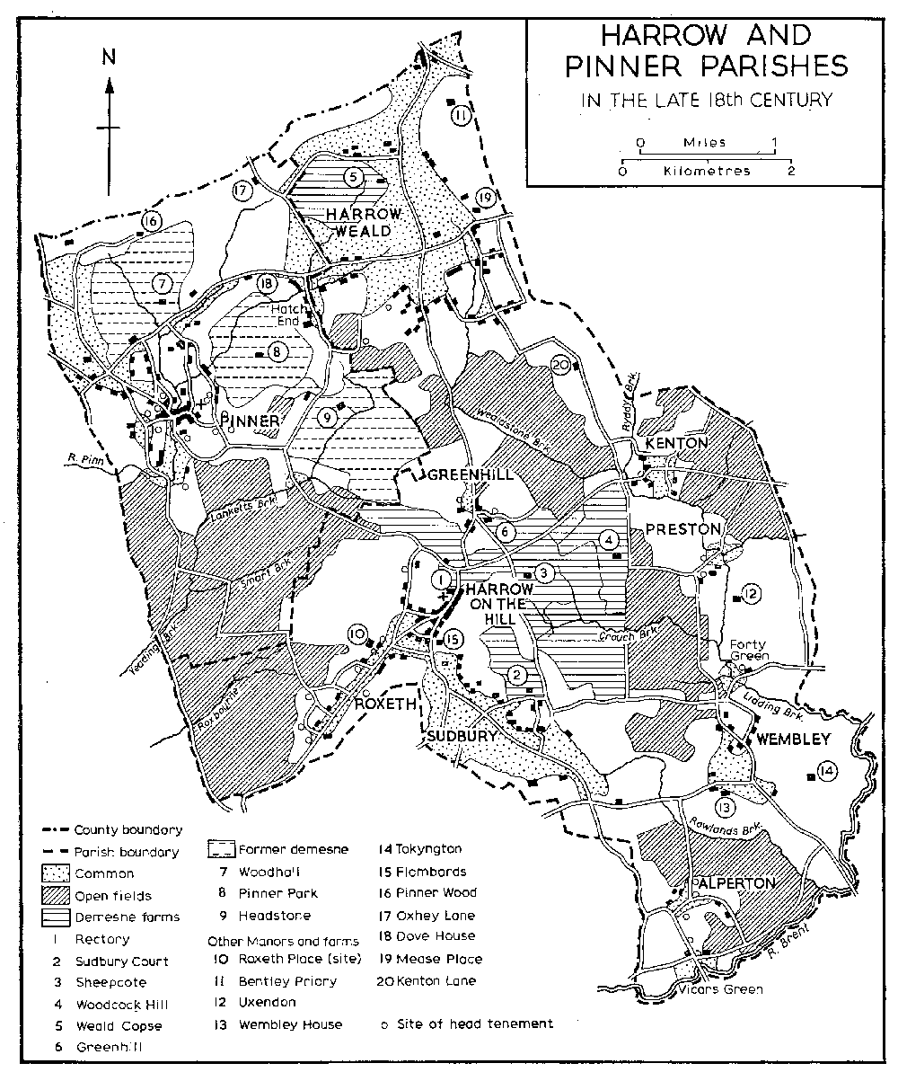
HARROW AND PINNER PARISHES In the late 18th century
The London or Harrow road attracted bequests from John Marshall, by will proved in 1507, (fn. 40) Thomas Page, by will proved in 1512, (fn. 41) Hugh Enystoo, by will proved in 1548, (fn. 42) and Henry Page, by will proved in 1558. (fn. 43) John Lyon (d. 1592) left 38 a. in Marylebone to Harrow School in trust for the repair of the road. (fn. 44) In 1754 it was said to be so bad that Harrow residents went to London via Acton (fn. 45) and in 1801, when it was 'narrow and incommodious', an Act was passed to set up a turnpike trust. (fn. 46) The trustees, whose survey stressed the inadequate drainage of the road in the south and its narrowness on Harrow Hill, erected a toll-gate and house near Harrow pound in 1801, and later erected turnpike gates at Roxborough and the northern entry to Sheepcote Lane. (fn. 47) After the misuse of funds by the highway surveyor in 1823, (fn. 48) the Harrow Road Trust was indicted by Quarter Sessions for the very bad state of the road from Harlesden to Harrow-on-the-Hill. James Macadam, son of the engineer, was elected surveyor and another survey described the road as 'circulous, dangerously narrow, confined by high banks with plantations and houses and with turnings almost at right angles', and as often impassable at the Brent crossing. (fn. 49) An Act was passed in 1826 (fn. 50) to make a more direct road from the 'Swan' at the edge of Sudbury Common to the crossing at Stonebridge, (fn. 51) but in the same year the trust was absorbed into the Metropolitan Roads Commission. (fn. 52) The river was diverted, the road was resurfaced with stone and the gradient of Harrow Hill was reduced. In 1830 the road to Harrow led to nowhere else 'of note' and therefore was not much used and in good repair. Harrow turnpike house and gate were abolished in 1847, but the commission administered Harrow Road until 1872. (fn. 53)
There was a slight rise in traffic before the railways killed the coach trade. In 1681 a coach left Harrow-on-the-Hill daily for Holborn and in 1690 'Mr. Page's waggon' left every other day. It still took a whole day for a waggoner to drive a team to London from Harrow c. 1800. (fn. 54) By 1826 there were two daily coaches from Harrow-on-the-Hill, from the 'Crown and Anchor' and the 'King's Head' to and from London. (fn. 55) The 'Crown and Anchor' coach continued to the 'Queen's Head' at Pinner. By then Pinner Road (formerly Roxborough Lane) had been much improved, mainly because of its link with Rickmansworth. In 1809 an Act (fn. 56) was passed to widen and improve the turnpike road from Rickmansworth through Pinner to the Harrow road at Roxborough and a toll-bar was erected at Pinner Green.
Continuous settlement in the parish probably dates from the Saxon period. There were three phases: firstly, settlement in farms and hamlets around village greens and their gradual growth by encroachment on the waste; secondly, after Parliamentary inclosure in 1817, building on former waste and common, especially alongside roads, but still within the original hamlets; thirdly, the development of farm-land as housing estates and new districts. The first two phases are dealt with under individual hamlets; the last phase, which was closely connected with the railways, is treated in a further section.