A History of the County of Middlesex: Volume 4, Harmondsworth, Hayes, Norwood With Southall, Hillingdon With Uxbridge, Ickenham, Northolt, Perivale, Ruislip, Edgware, Harrow With Pinner. Originally published by Victoria County History, London, 1971.
This free content was digitised by double rekeying. All rights reserved.
Diane K Bolton, H P F King, Gillian Wyld, D C Yaxley, 'Harrow, including Pinner : The growth of the hamlets', in A History of the County of Middlesex: Volume 4, Harmondsworth, Hayes, Norwood With Southall, Hillingdon With Uxbridge, Ickenham, Northolt, Perivale, Ruislip, Edgware, Harrow With Pinner, ed. T F T Baker, J S Cockburn, R B Pugh (London, 1971), British History Online https://www.british-history.ac.uk/vch/middx/vol4/pp172-198 [accessed 2 May 2025].
Diane K Bolton, H P F King, Gillian Wyld, D C Yaxley, 'Harrow, including Pinner : The growth of the hamlets', in A History of the County of Middlesex: Volume 4, Harmondsworth, Hayes, Norwood With Southall, Hillingdon With Uxbridge, Ickenham, Northolt, Perivale, Ruislip, Edgware, Harrow With Pinner. Edited by T F T Baker, J S Cockburn, R B Pugh (London, 1971), British History Online, accessed May 2, 2025, https://www.british-history.ac.uk/vch/middx/vol4/pp172-198.
Diane K Bolton, H P F King, Gillian Wyld, D C Yaxley. "Harrow, including Pinner : The growth of the hamlets". A History of the County of Middlesex: Volume 4, Harmondsworth, Hayes, Norwood With Southall, Hillingdon With Uxbridge, Ickenham, Northolt, Perivale, Ruislip, Edgware, Harrow With Pinner. Ed. T F T Baker, J S Cockburn, R B Pugh (London, 1971), British History Online. Web. 2 May 2025. https://www.british-history.ac.uk/vch/middx/vol4/pp172-198.
The Growth of the Hamlets
Harrow-On-the-Hill.In 767 Offa made a grant of land between the Lydding and 'geminga hergae'. The latter, generally interpreted as 'the temple of the tribe or sons of Gumen', appears to have been a specific landmark. (fn. 1) The gravel-capped hill, rising abruptly above the wooded plain, was an obvious site for a heathen, probably Saxon, temple or sacred grove. (fn. 2) The name Harrow, therefore, seems to have been first applied to the hill, and then to the whole parish, 'on-the-Hill' being added from the end of the 14th century to distinguish the original area. (fn. 3)
In spite of its temple and well-water, (fn. 4) there is no evidence that Harrow-on-the-Hill was the first permanent settlement in the area. A major factor in the growth of Harrow Town was the presence of the parish church and priest. It would have been natural for the Church to have founded its first mission on the site of the pagan sanctuary. There was a priest by 1086 (fn. 5) and the probable identification of his holding with the later rectory demesne (fn. 6) suggests that he lived on the hill. The account of the consecration of the first church of St. Mary, in 1094, does not mention a village, but it does indicate something resembling the later pattern of roads around the hill. (fn. 7)
The 'tenants of the church', mentioned in 1233- 40, (fn. 8) were probably the 13 capital tenants (fn. 9) who held messuages in Harrow Town and virgate estates north of the hill. (fn. 10) By the 14th century the head tenements had been permanently split up among many undertenants, (fn. 11) often smallholders of servile status who subsisted on the produce of a few selions and by animal husbandry. Eighteen people were charged pannage on Rectory manor in December 1368. (fn. 12) There were also some freehold estates, the most important of which was Flambards manor. (fn. 13) By 1553 (fn. 14) there were 12 capital tenements, five lesser tenements, and four freehold estates. In 1724 (fn. 15) there were 21 and by 1800 (fn. 16) 25 tenants of Rectory manor. (fn. 17) Growth was helped by the grant of a weekly market and annual fair in 1261. (fn. 18) One of the appurtenances of Rectory manor in 1553 was the farm of three shops. Brewing and the leather trades were especially prominent: boots were sold without the lord's licence in 1394 and uncured shoes were sold in 1507. (fn. 19) A tailor was mentioned in 1557, (fn. 20) a brick-maker in 1589, (fn. 21) and a bricklayer in 1640. (fn. 22)
The original settlement of Harrow-on-the-Hill was probably along High Street south of the church and along Hog Lane, later Crown Street, and West Street. Six tenements, four of them capital messuages, were among the endowment granted by John Lyon to Harrow School in 1575. (fn. 23) They can probably be identified with the land held by the school at inclosure, mostly in the corner formed by West Street and High Street, and in two blocks on the east side of High Street. Other customary and capital tenements, enfranchised in the 19th century, were in High Street, at the corner of Middle Row and Byron Hill Road, and in West Street. (fn. 24) In West Street, too, was Pie-Powder House, (fn. 25) where cases arising from the market held at the corner of West Street and High Street were tried. There were 8 increments or parcels of waste in 1553 and 16 by the end of the century. (fn. 26) Some of these were for new houses or cottages. Twelve out of 14 wastehold parcels in 1681 (fn. 27) involved buildings, one of them a 'house newly erected'. Nine cottages, six messuages, and two inns, were among 18th-century wastehold property. (fn. 28) Eighty-one houses were listed for the 1664 hearth tax, (fn. 29) of which more than half were not charged. Three were large: Flambards, with 25 hearths, the Rectory, with 17 hearths, (fn. 30) and a house with 10 hearths owned by Daniel Waldo. Thirty-four houses had only one hearth. Fifty-three houses were charged in 1672. (fn. 31)
In 1759 settlement was concentrated along High Street between the churchyard and the junction with West Street, with buildings presenting a continuous front to the street. A more scattered string of buildings lay on either side of High Street, south of West Street, and between Hog Lane and West Street. A few houses lay north of West Street and south of Byron Hill Road, in which also were the brick-kilns leased to the Bodymeads. (fn. 32) Isolated, east of London Road, almost opposite the shooting butts, stood Flambards, marked as 'Mrs. Stapleton's'. (fn. 33)
Opposite the church the road divided and, as Church Hill and Grove Hill, formed a loop around some rectory land, on which were some houses and a hanging garden. (fn. 34) The road ran northward to Tyburn Hill, where it split into three: Roxborough Lane (fn. 35) or Lowlands Road, which ran alongside the Rectory estate to Pinner, (fn. 36) Greenhill (fn. 37) or Harrow Lane, which formed the eastern boundary of the Rectory lands and joined Harrow with Greenhill and the north, and Tyburn Lane, which ran eastward through demesne lands. (fn. 38) On either side of Tyburn Lane in its Harrow section lay Redings and Dodses, 50 a. of demesne land. (fn. 39) South of its junction with Church Hill, High Street divided into two, forming the northeastern corner of a square of roads linking Harrowon-the-Hill, Roxeth, and Sudbury. The southern continuation of High Street was London Road, which linked Harrow-on-the-Hill with Sudbury. Parallel with it on the west was Lower Road, a continuation of the road running northward from Northolt to join Lowlands Road and Pinner. Joining London Road and Lower Road were West Street, and, south and parallel with it, London or Roxeth Hill. Hog Lane or Crown Street was a diagonal road running southwestward from West Street, which at the centre of the square looped back, as West Hill or Byron Hill Road, to join London Road.
There were at least three inns in 1759. The 'Crown and Anchor' in High Street (fn. 40) was mentioned, as 'le Anker', in 1683 (fn. 41) and may have been much older. The 'Castle' in West Street (fn. 42) existed by 1716 (fn. 43) and the 'King's Head', on the west side of High Street, was licensed from 1751. (fn. 44) The 'Bricklayers' Arms', licensed in 1751, (fn. 45) may be identified with an unnamed beershop in Crown Street, mentioned in 1852, (fn. 46) and with a beershop of the same name which was closed in 1907. (fn. 47) Other inns which may have been located in Harrow Town were the 'Queen's Head', licensed in 1759, (fn. 48) and a second 'King's Head', licensed 1751- 1800 (fn. 49) and perhaps identifiable with a messuage on the east side of High Street, which was described in 1872 (fn. 50) as 'many years since called the Upper King's Head Inn'. The 'Plough' in Hog Lane, licensed in 1760, (fn. 51) may be identifiable with the Crown Inn, (fn. 52) first licensed under that name in 1785. (fn. 53)
The basic road pattern has remained unaltered. The main developments between 1759 and 1817 (fn. 54) was the extension of Hog Lane, as Middle Row or Road, to the south-west corner of the square. The expansion of Harrow Town down the southern slope of Harrow Hill gathered impetus after inclosure. (fn. 55) Small, terraced houses were built fronting Crown Street, West Street, Byron Hill Road, and London Road. The population in 1831 (fn. 56) was given as 1,345. In 1841 (fn. 57) it was 1,359, when 167 houses were inhabited, but some of the items for Harrow Town were probably included in those for Roxeth. In 1851 (fn. 58) Harrow Town had a population of 1,660 in 203 houses and four inns, giving a very high density of 8 people to a house. This is partly explained by the existence of large houses for the Harrow schoolboys and many servants. There was also much overcrowding in the centre, where insanitary conditions led to cholera outbreaks in 1847 and 1848 and a subsequent public health inquiry. (fn. 59)
Public buildings in 1852 (fn. 60) included a Baptist chapel, post office, police station, and fire-engine house. There were also three forges, a slaughterhouse, the 'King's Head', 'Crown and Anchor', 'Castle', and 'Crown', two beerhouses, the 'Wheatsheaf' (fn. 61) at the junction of Middle Row and Byron Hill Road, and the 'White Hart' (fn. 62) in High Street. A beer-shop in Crown Street, probably the 'Load of Hay', was later called the 'Wheatsheaf' and may be identifiable with the 'Bricklayers' Arms' or the 'North Star'. (fn. 63)
West Hill, (fn. 64) of which only the northern part existed in 1852, was completed by 1859, (fn. 65) as was Brickfields, as yet unnamed. By 1865 two other small roads, Waldron Road and Victoria Terrace, had been built within the main square, and Nelson Road led from West Street to Trafalgar Terrace. East of High Street, the south section of Peterborough Road had appeared, but Northwick Walk and Football Lane were still only paths through fields. (fn. 66) Houses were being built on any available space in the town, (fn. 67) but mainly in the north, on the former Rectory demesne on either side of Lowlands Road. Roxborough Villas were built between 1852 and 1860 (fn. 68) on the eastern side of a path from St. Mary's church to the junction of Lowlands and Bessborough roads. Between Lowlands Road and Greenhill Lane (by 1871 called Station Road) (fn. 69) a series of roads, College, Roxborough, Kymberley, Headstone, (fn. 70) New (later Clarendon), Byron, and the still unnamed St. Anne's Road, had been laid out by 1865, although there were still only a few houses, mainly between St. Anne's and College roads and north of Lowlands Road.
The opening of Harrow-on-the-Hill station just north of Lowlands Road in 1880 accelerated development nearby. (fn. 71) Some houses in Roxborough Park existed by 1882 (fn. 72) and by 1887 the land west of it was divided into building lots. (fn. 73) A Roman Catholic church was built there in 1894 (fn. 74) and development was well advanced by 1897. (fn. 75) Peterborough Road had been continued up to its junction with Station Road by 1889 and the land between it and Grove Hill was also divided into lots. (fn. 76) By 1898 (fn. 77) houses extended solidly northward to Greenhill and westward along the Metropolitan Railway line towards Pinner and Headstone.
In spite of the spread of building, Harrow-on-theHill itself has remained remarkably free from wholesale development. Much of the credit for this is due to Harrow School. It was during the 19th century, especially, that the school's influence was extended over the town. At inclosure the largest estates were still those of the Rectory held by James Edwards, (fn. 78) and Flambards, which Lord Northwick divided and leased out. (fn. 79) In comparison with most properties the school estate, then comprising the school-house, a master's house (probably Druries), 11 messuages, some of them divided into several tenements, a butcher's shop, and some pasture land, (fn. 80) was quite large. During the 19th century several mansions were leased or purchased as boarding houses, each usually containing a master and his family, a number of servants, and from 13 to 50 pupils. In 1851 there were seven of these houses, (fn. 81) including Harrow Park, the successor to Flambards. (fn. 82) In 1884 the lease of Harrow Park expired, (fn. 83) and, lest building should spread southward from north Harrow, the Harrow Park Estate Trust was set up to buy property for the school. (fn. 84) Between 1884 and 1898 220a. were acquired, including portions of the old demesne lands of the Rectory and Sudbury manors. (fn. 85) This has resulted in the preservation of large open spaces around the town, giving it a setting of parkland, playing fields, and gardens.
A few buildings have survived from the 17th century and earlier. The oldest is the former PiePowder House, probably dating from the 15th century, the remains of which stand in a yard at the rear of no. 75 West Street. (fn. 86) The rectangular timberframed structure, originally single-storied, retains a fine arch-braced tie-beam roof truss, incorporating a crown-post with four-way struts. The King's Head Hotel, at the junction of High Street and Byron Hill Road, has a Georgian and Victorian frontage but parts are reputed to date from 1533. Further north in High Street no. 48, perhaps formerly the White Hart Inn, (fn. 87) is a timber-framed building behind a brick façade. In West Street no. 13 has a jettied gable-end and is part of a timber-framed house, probably of the 17th century. At the Old House (no. 5 High Street) a 19th-century tile-hung and gabled top story has been added above the original eaves cornice but the structure is otherwise of c. 1700 with traces of earlier work internally; it is thought to have been the Queen's Head Inn, (fn. 88) mentioned in 1759. With the adjoining buildings the Old House forms a group of dignified Georgian and Regency frontages on the east side of High Street. Further south is no. 11, a detached late18th-century house of yellow brick with a symmetrical three-storied front and a pedimented doorway. (fn. 89) Many of the late-18th- and early-19th-century domestic buildings are small dwellings in High Street, West Street, and Crown Street, often altered and with inserted shop fronts. There are also several detached residences, both large and small, on the slope of the hill west of High Street. Many of the larger private dwellings in and around the town are or have been used as boarding houses for Harrow School; the more important of them are mentioned below. The growth of the school in the 19th century and the increased prosperity of the town led to considerable rebuilding and infilling along High Street. This is particularly noticeable round the small square at the junction of High Street, Byron Hill Road, and London Road; here Victorian frontages predominate. There are also many middle-class houses of this period, detached and in pairs, on both sides of London Road. The 20th century, on the other hand, has made little impact. In this respect Harrow-on-the-Hill forms a striking contrast to the suburban areas surrounding it.
As High Street leads northward to the parish church it becomes increasingly dominated by Harrow School until, at the foot of Church Hill, the main group of school buildings is reached. Older houses here were cleared away as the school expanded, so that no strict demarcation between town and school has ever been apparent. The principal buildings, erected singly over a considerable period, are mostly of red brick and show a variety of architectural styles, the favourite being a scholastic Tudor in all its 19thand early-20th-century forms. (fn. 90)
The original school building, designed according to John Lyon's instructions but not completed until 1615, stood on the steep slope to the west of Church Hill. It was a rectangular brick structure of two stories, basement, and attics. A small wing, containing the entrance and staircase, projected from the east side. (fn. 91) The schoolroom occupied the first floor, with a governor's room and living rooms for the master and usher above it. In 1819-20 the building was more than doubled in size by the addition of a new east wing of approximately the same dimensions as the original school; the architect was C. R. Cockerell. Both old and new wings were embellished with oriel windows and crow-stepped gables. The entrance was moved to the centre of the south front where it is approached from the school yard by a long flight of steps and an arcaded porch. The roof is crowned by a combined clock turret and bell cupola. The building, known as the Old Schools, contains the original schoolroom with many of its fittings intact; they include the boys' benches, the masters' canopied chair and desk, the usher's table, and wainscotting on which generations of boys carved their names between 1701 and 1847.
Cockerell also designed the first school chapel, built on the east side of High Street in 1838-9. It was a red-brick building with a south-west bell turret and a curvilinear west gable above a large Perpendicular window. (fn. 92) The old chapel was replaced in stages between 1854 and 1857 by the present building, designed by G. G. (later Sir Gilbert) Scott in the Decorated style and built of flint with Bath stone dressings. When complete the chapel consisted of nave, north and south aisles of different widths, and an apsidal chancel; the spired bell turret was added in 1865 and the transepts and porches in 1902. Flanking the chapel to north and south respectively are the New Schools (1855) and the Vaughan Library (1861-3). The former, by F. Barnes, is of diaper-patterned red brick in a domestic Tudor style; it was extended in the 20th century. The Vaughan Library was designed by Scott as a symmetrical Gothic Revival building of variegated brick with elaborate stone dressings. (fn. 93) In 1874-7 the Speech Room was built on the opposite side of the road with funds raised to celebrate the tercentenary of John Lyon's charter. As the principal assembly hall of the school it was built on a semicircular plan, the vaulted interior having tiers of seats following the curve of the back wall. The exterior design incorporates Venetian Gothic features, made popular by John Ruskin; the architect was William Burges. The straight front has a balcony on massive stone brackets with an arcaded row of Gothic win dows above it. Of the two angle towers, that to the south was not completed until 1924; the statue of Queen Elizabeth on its front wall was brought from Ashridge Park in the following year. Soil excavated from the foundations of the Speech Room was used to build up the terraces on the slope behind the chapel. At the north end of the terraces stand the Science Schools, built in 1874-6 to the design of C. F. Hayward and much enlarged later, and the tall gabled building housing the Museum Schools. The latter, completed in 1886, was designed by Basil Champneys in the 17th-century 'Dutch' style then fashionable; its lavish use of moulded brickwork and the arcaded angle staircase were much admired. (fn. 94) The Art School was built to the north of the Speech Room in 1896 to the design of W. C. Marshall and was extended in 1913. The most conspicuous 20th-century contribution to the school group is the War Memorial Building, erected in 1921-6. It stands behind a paved forecourt at the junction of Church Hill and High Street on a site previously occupied by older buildings used as boarding houses. The ground floor contains a memorial shrine and a ceremonial corridor leading from the forecourt to the south entrance of the Speech Room. The architect, Sir Herbert Baker, tried to harmonize his design with the adjacent buildings by using red brick, flint, stone dressing, and a mainly 17thcentury style. The attempt to introduce some formal relationship between the school buildings was carried further in 1929 when houses and shops on the west side of High Street were demolished. This opened up a view of the Old Schools and gave them an axial approach from the south. The sloping site was laid out with flights of steps, lawns, and balustrades.
The Headmaster's House, on the opposite side of High Street, occupies the site of a dwelling already being rented by the schoolmaster in the 17th century. It was later enlarged to accommodate boarders, and early in the 19th century was remodelled at a cost of over £6,000. A print of 1816 shows a two-storied gabled front in the 'Tudor' style of the period with a central porch, embattled parapets, and two flanking bay windows; (fn. 95) a long wing to the north housed studies for the boys. The house was destroyed by fire in 1838, only an addition of 1836 being saved. Rebuilding took place in 1840 and a few years later a boys' wing was added and the street front was raised to three stories. Further additions were made in 1866 and 1897. The present red-brick front is largely of the mid 19th century. Tudor features include the projecting porch, the small gables to the parapet, and the hood-moulds and four-centred heads to several windows.
The main school group is continued north-eastward by a number of boarding houses built between 1850 and 1900. Nearly all are tall gabled buildings of red brick, some with Gothic features. Also in this area are the Old Music School (1873), the Copse (1901-4), and the Leaf Schools (1936). On the fringes of the group are the gymnasium and workshop (1874- 6) and the New Music School (1890). The old sanatorium, opened in 1867 and now derelict, stands in Mount Park Avenue.
Several of the school boarding houses were first opened in existing houses in the town. The Grove, standing on the ancient rectory site at the summit of the hill, (fn. 96) was acquired c. 1820. It was burnt down in 1833 and rebuilt, the symmetrical Georgian front of seven bays being preserved. The building has been altered and extended at several periods. The former hanging garden belonging to the rectory occupied the steep slope between the house and what is now Grove Hill. Druries, set back from the west side of High Street at its north end, originated in a house called the Abbey. It became a boarding house at the end of the 18th century and was rebuilt in a Victorian Gothic style by C. F. Hayward in 1864. Moretons, which has a long stucco front facing the east side of High Street, was opened in 1811, rebuilt in 1828, and enlarged later. The Park stands further south and has extensive grounds falling away eastward to an ornamental lake. It was built in 1795 to replace the manor-house of Flambards and was enlarged for Lord Northwick in 1803. (fn. 97) The original approach was by a long drive from Sudbury Hill, leading to a main entrance on the east front. This front, stucco-faced like the rest of the building, retains two flanking bay windows with firstfloor iron balconies. It was enlarged three times in the 19th century, after becoming a boarding house, and part was given an extra story in 1906. At this date an enriched tympanum and a Coade stone relief of a lion guardant (part of the Northwick arms) were moved from the centre of the east front to the street wall of the south wing. Bradbys, opposite the Park, is a building of grey brick with stone dressings and a classical porch, dating from 1849; it has two distinct wings which were combined as a single boarding house in 1864. Byron House in Byron Hill Road, formerly called Pond House, is no longer a boarding house but was used as such for most of the 19th century; it was the home of Matthew Arnold for a few years c. 1870. Its nucleus is a red-brick structure of three stories which may have been built by Thomas Brian, headmaster from 1691 to 1730. (fn. 98) On the west side of London Road is West Acre, converted to a boarding house from a pair of private dwellings in 1847; it was rebuilt after a fire in 1908. Other houses, including Newlands (1888), stand in Harrow Park, a cul-de-sac on the east side of London Road.
Pinner, in the north-eastern corner of Harrow parish, was on gravel-capped high land, with a river and wells. (fn. 99) Except for some Roman finds, (fn. 100) however, there is little evidence of early settlers and the etymology of the name is obscure. As a family name, 'de Pinnora', it first appears in 1232. (fn. 101) The first element may represent a personal name or the Old English pinn, 'pin' or 'peg', while the second element could be the Latin for 'bank or slope'. The river name, Pinn, is generally supposed to be a late back-formation. (fn. 102) Although evidence of Anglo-Saxon and early medieval occupation is completely lacking, Pinner appears in 1315-16 as one of the largest hamlets, with at least two tithings. (fn. 103) A new chapel was consecrated in 1321 (fn. 104) and in 1336 Pinner was granted a weekly market and an annual fair. (fn. 105) In March 1383 24 people were presented for breaking the assize of ale, twice as many as in any other hamlet. (fn. 106) By 1547 there were said to be 300 communicants in Pinner, nearly 20 per cent. of the total for Harrow parish. (fn. 107) In addition to the copyhold tenements, there were 10 freehold houses and one wastehold house. (fn. 108)
The settlement pattern, small hamlets and farms linked by a maze of lanes across a large common, was apparent by the 14th century. Eleven of the 21 head tenements can be located: there were four in West End, Sweetman's Hall, (fn. 109) Clogges, Neoles, (fn. 110) and Aldridges; (fn. 111) one, Roughheads, in Love Lane (fn. 112) and another in Bridge Street; (fn. 113) two in East End, Marshes (fn. 114) and Cockparkers; (fn. 115) three around Nower Hill, of which one was called Nower Hill (fn. 116) and another Newhouse; (fn. 117) one at each end of Pinner Marsh, (fn. 118) and one, Gardiners, in the extreme north, between Potters Street and the shire ditch. (fn. 119) Others probably lay near Paines Lane, (fn. 120) East End, (fn. 121) and on the highway from Pinner to London. (fn. 122) Place-names further suggest the scattered character of the medieval settlement. Waxwell is recorded in 1274, (fn. 123) East End and Nower Hill in 1315-16, (fn. 124) Pinner Marsh in 1333, (fn. 125) Pinner Hill in 1334, and West End in 1448. (fn. 126) The surname 'de la Hacche' indicates the existence of Hatch End c. 1300. (fn. 127) Hatch End formed the boundary between Pinner and Harrow Weald, and for assessment, tithing, and open-field purposes seems always to have been divided between them. Headstone is first recorded c. 1300 as 'Hegton' or 'Heggeton', (fn. 128) home of the de la Hegge or de la Haye family mentioned as early as 1233-40. (fn. 129) There was probably a small settlement before the creation of the demesne farm here. (fn. 130)
Conversion of the forest to arable south and west of Pinner Town seems to have been well advanced by 1232. (fn. 131) It is probable that the three-field system was then already in existence. From the early 14th century, at least, the common fields were East or Long Field, Middle Field, and Down Field. (fn. 132) They were roughly rectangular and lay side by side south of Pinner Town and north of Roxeth common fields; Down Field, on the Ruislip border, was in the west, and Long Field in the east. (fn. 133) Nower Field, which lay to the east of Pinner Road, south of Pinner Park, was by 1817 a small, isolated field. (fn. 134) Hyde and Roxborough Field, first mentioned in the early 16th century, (fn. 135) which joined Long Field on the east, and Hill and Home Field, mentioned in the 18th century, (fn. 136) were probably all associated with the small hamlet at Hyde End. Blakehall Field, which occurs from the 14th to the 16th century, can probably be identified with Roxeth Newden Field. (fn. 137) The 1547 survey (fn. 138) lists 541 a. of inclosed mainly freehold land, and 540 selions of openfield, mainly copyhold land, but not all holdings are described. At inclosure Pinner common fields covered 940a. (fn. 139) In the north and east two demesne manors had been created out of the forest by 1273-4. (fn. 140) Pinner Park probably remained woodland for most of the Middle Ages, since it was primarily a hunting enclosure, (fn. 141) but Woodhall, already in existence by 1236, (fn. 142) was an arable area of about 312 a. in the north of Pinner by c. 1285. (fn. 143) Headstone was converted into another predominately arable demesne farm after 1344. (fn. 144) There was also some assarting and inclosure and the creation of small estates which were held by socage or leased out, either separately or with one of the large demesne farms. In 1489-90 there were eight of these, mostly in the north, (fn. 145) the names of many of them retaining the element 'riding' or 'redding', which indicates their origin in clearings. (fn. 146) The most important of these was Woodridings, 158 a. to the east of Woodhall, (fn. 147) and Pinner Wood, 120 a. in the extreme north-west. (fn. 148) The northern part of Pinner at the end of the 16th century was still 'hilly and woody' (fn. 149) and even in the 1830s Albert Pell's boyhood memories of Pinner Hill stressed the loneliness of life in the house 'at the edge of a great wood'. (fn. 150)
Medieval Pinner was a settled area bounded on the north and east by demesne farms and assarts, on the west by closes, and on the south by open fields. It consisted of moderately sized estates: virgates and ½- hides. By 1547 some consolidation had taken place: the 21 head tenements were held by 15 tenants, many of whom also held freehold land, of which there were 320 a. and 54 selions. (fn. 151) Most of the land was held by the Edlins, Streets, Readings, and Birds, who dominated Pinner during the 16th and 17th centuries, (fn. 152) but by the end of the period important newcomers were building country houses. The interest of outsiders was already apparent in the 16th century when the Bacon family leased Pinner Park. (fn. 153) In the 17th century there were Sir Christopher Clitherow (d. 1641), Lord Mayor of London and Governor of the East India Company, and his son, also a London merchant, who owned Pinner Hill and Pinner Wood, (fn. 154) Sir Edward Waldo (d. 1707), (fn. 155) Simon Rewse of Headstone, the Royalist, (fn. 156) and Sir Bartholomew Shower (d. 1701) of Pinner Hill, a judge at the trial of the seven bishops. (fn. 157) In the 18th century there were Lord and Lady Hunsdon at Church House and at Cannons mansion-house, (fn. 158) which existed by c. 1630, (fn. 159) the poet laureate Henry John Pye (d. 1813), who gave occasion for the nursery rhyme 'Sing a song of sixpence', who lived at East End House, (fn. 160) and Sir Michael Foster (d. 1763), a justice of the King's Bench, at the Grove in Pinner Marsh. (fn. 161) John Zephaniah Holwell (d. 1798), Governor of Bengal and survivor of the Black Hole of Calcutta, lived at Pinner Place. (fn. 162) James Lightboun (d. 1738), Master of Chancery, and Lady Jane Brydges, lived in Pinner Hill, (fn. 163) Admiral John O. Spranger at Pinner Hall, (fn. 164) and Charles Palmer (d. 1777) at Paines Place (fn. 165) and the 18th-century Pinner House. (fn. 166) Farm-houses on the site of ancient head tenements, for example Nower Hill Cottage (fn. 167) and Sweetman's Hall, (fn. 168) illustrated the prosperity of local families. Cottages included one newly erected near Waxwell in 1655, (fn. 169) which was part of an underset holding, and no. 33 Love Lane, built in the late 17th century. (fn. 170) Several of the medieval farm-houses on the demesne manors were rebuilt. (fn. 171) Wastehold properties multiplied from 16 in 1553, (fn. 172) including 3 barns and a smith's house and forge, to 33 c. 1600. (fn. 173) There were 44c. 1642, (fn. 174) when 186 adult males took the protestation oath. (fn. 175) Twenty-two years later 143 houses were listed for the hearth tax, 61 more than in Harrow Town, (fn. 176) although only 64 were charged. John Hawtrey was assessed for 15 hearths (fn. 177) and John Hutchinson for 14; (fn. 178) two others were assessed for 10 hearths and John Edlin for 8 hearths.
There were 85 parcels of wastehold by the end of the 17th century, (fn. 179) many of which had been granted recently for the first time. They included 13 cottages, among them one at Bury Pond Hill (1665), one at Pinner Green (1672), one each at Pinner Marsh and Pinner Bridge (1682), one in Pinner Street near the church (1696), one in Waxwell Lane, and three on Pinner Common at an unknown date. Other wastehold properties included 17 barns and cart- or woodhouses, a shop and slaughter-house, a smith's shop, a bowling-alley, and a long walk planted with elms before Cannons mansion-house. Most of the other parcels were yards or orchards, usually adjoining a dwelling-house. Encroachment continued when 46 new parcels were granted, mostly in the first and third decades of the 18th century. (fn. 180) Twenty-seven supported cottages or larger houses, including a nonconformist meeting-house and the poor-house. Three cottages were at Bury Pond Hill, two at Hatch End, two at Pinner Green, and one each in the Marsh, West End, Pinner Town, and Pinner Wood Lane Green. Very few barns or cart-houses were erected, most of the other parcels being small inclosures and including two rows of trees which probably formed a drive to Pinner Hall. In addition to the wastehold property there were new cottages or messuages at West End in 1747 (fn. 181) and Bury Pond Hill in 1755. (fn. 182)
By 1759 Pinner had a complicated system of roads. (fn. 183) There were two north-south routes: one on the west side, from Potters Street Lane across Pinner Common, through West End and the common fields, where it became Bourne or Rayners Lane, (fn. 184) to Roxeth; the other route, on the east, ran from Oxhey Lane, through Hatch End and Hooking or Hooken Green to Harrow-on-the-Hill, (fn. 185) and was connected to Pinner Town through Nower Hill. A road ran from west to east along the southern edge of Woodhall Farm to Hatch End and the Weald. The hamlets of Pinner, Pinner Hill, West End, Pinner Town, East End, Pinner Marsh, and Bury Pond Hill, were linked by a series of access roads.
Two branches of the Pinn joined just north of Pinner Town, to flow southward through the town and Pinner Marsh and then turn west at Cannons Farm. Further south, the Yeading Brook flowed from east to west across the common fields into Ruislip parish. One of the earliest bridging points must have been at the western end of Pinner Town. The 1759 map shows the Pinn running across a broad road from Pinner Town to Pinner Marsh. At each side of this ford there was a footbridge, which in 1686 (fn. 186) was the responsibility of the lord of the manor. The ford was inadequate for the traffic from Harrow to Rickmansworth, and in 1809 a brick bridge of two arches was built by the trustees of the Rickmansworth turnpike, who repaired it in 1820. It was unsatisfactory by 1894, and a few years later a new bridge was built by Pinner Parish Council. (fn. 187) Pinner Marsh, to the south-west of Pinner Town, was especially subject to flooding, and no road across it is marked in 1759. In 1728, however, Lady Hunsdon rebuilt a bridge near Cannons Farm, which may be identifiable with Pinner Marsh Bridge, a wooden footbridge mentioned in 1686-7. Before inclosure a road from Hunsdon Bridge led south-westward through the open fields to Eastcote. In 1806 it became a cul-de-sac, and Rayners Lane to the east became the main route to Roxeth, while a new road to Eastcote was built to the west. Where previously the road to West End had run beside the river to Cannons Farm, it was diverted northward to join the new road just north of its bridging point. The road across Pinner Marsh appears on post-inclosure maps, which show it bridging the Pinn again just north of Pinner Grove. (fn. 188) The eastern branch of the Pinn was crossed by Paines Lane at Paine's Bridge, which was repaired by the lord of the manor in the late 17th century, (fn. 189) although in 1814 Lord Northwick asserted that the vestry was responsible. (fn. 190) There were at least two other crossings over the branches of the Pinn along the Uxbridge road in 1686: Lewis Bridge, at Bury Pond Hill, was a wooden footbridge by a ford, and Woodhall Bridge was a stockbridge repaired by Mr. Wilkinson, the owner of Woodhall Farm. (fn. 191) In 1825 there were said to be three fords and footbridges on this road. (fn. 192) Except at Headstone manor, by whose entrance a new bridge was built c. 1466, (fn. 193) the Yeading Brook had only Hooking Green Bridge, a footbridge on the London-Pinner road. In 1685 it was a 'danger to life and goods', but the lord of the manor, who was urged to repair it, seems to have denied responsibility. (fn. 194) To the west of Hooking Green, Bourne (later Rayners) Lane crossed the Yeading Brook but was unbridged until the late 19th century. (fn. 195)
By 1759 the common had been reduced to little more than 260 a., made up of Pinner Common or Green (195 a.) and a number of small commons: (fn. 196) Bury Pond Hill (25 a.), Pinner Marsh (26 a.), Pinner Hill Green (11 a.), and Hooking Green (fn. 197) and Hatch End. (fn. 198) There were about 184 buildings in Pinner. (fn. 199) Houses and shops presented a continuous front on either side of Pinner High Street, thinning out slightly along Church Lane, the southern part of Paines Lane, Bridge Street, and Marsh Road. There were smaller groups in West and East End, at Pinner Wood Lane Green, (fn. 200) and at Hatch End. There were scattered settlements at Bury Pond Hill, along the northern part of Waxwell Lane, in Pinner Marsh, Nower Hill, and Pinner Hill, and along the southern edge of Pinner Common where the Bell Inn already stood. Isolated farms were Headstone, Pinner Park, Woodhall, Cannons, Dove House, and Oxhey Lane.
There were several inns in 1759. (fn. 201) The 'Queen's Head' at the upper end of the High Street, was licensed from 1751. (fn. 202) The 'Red Lion' in Bridge Street existed by 1737; (fn. 203) it was rebuilt in 1875 and demolished in 1963. (fn. 204) The 'George' in Marsh Road, which was rebuilt in 1889, was also licensed from 1751, (fn. 205) as was the 'Bell' on Pinner Green in the north, which has been rebuilt several times, most recently in 1930. (fn. 206) The Crown Inn (closed in 1896) (fn. 207) and the White Hart beershop, both in the High Street, were first licensed in 1759. The 'Crown' may be identifiable with the 'Lower Queen's Head', which was licensed in 1751 but disappeared from the lists after 1759. Other Pinner inns, whose whereabouts are unknown, were the 'Chequers', licensed from 1751, a second 'Chequers', licensed in 1759, and the 'Crooked Billet', licensed 1759-60. (fn. 208)
In 1801 there were 140 inhabited houses and a population of 761. (fn. 209) These figures, compared with those of 1664, suggest that the 18th century was a period of rebuilding rather than of expansion. The distribution of houses in 1805 was essentially the same as in 1759. (fn. 210) There were about 52 houses in Pinner Town, including the inns and the poor-house. Eighteen houses, mostly cottages but including a windmill and the Bell Inn, were scattered across Pinner Common, mainly along the southern edge. West End, with two farms and 11 houses, was the next most densely populated area, followed by Pinner Wood Lane Green with about 13 cottages, and Hatch End, with a farm and about 8 other houses. (fn. 211) East End also had about 9 houses, and there were between 3 and 5 houses in each of the other hamlets, Pinner Marsh, Bury Pond Hill, Waxwell, Nower Hill, and Pinner Wood. Apart from a few farm cottages at Headstone, the isolated farms were as in 1759. More houses were built early in the 19th century, (fn. 212) especially on the waste, which was further reduced by 1817 to 196 a., 162 a. of which formed Pinner Common. (fn. 213) In 1811 there were 1,078 people in 167 houses but by 1821 there were still only 1,076 people in 181 houses. Ten years later there was a population of 1,270. In 1841 the 1,331 inhabitants included 56 haymakers living in barns, which explains the apparent drop to 1,310 in 1851, when there were 258 inhabited houses. The opening of Hatch End railway station in 1844 created new settlement areas, and made Pinner attractive to wealthy Londoners. In 1851 there were six landed proprietors, (fn. 214) three 'proprietors of houses', five 'fundholders', three merchants, seven members of the legal and three of the medical profession, a publisher, a portrait-painter, a civil engineer, an army magistrate, a 'gentleman', and an 'independent lady'. (fn. 215) Nineteenth-century inhabitants included the Milman family of the Grove, of whom the first, Sir Francis Milman (1746-1821), was physician to Queen Charlotte, (fn. 216) Edward BulwerLytton, who wrote Eugene Aram in 1831-3 at Pinnerwood House, (fn. 217) Mrs. Beeton (d. 1865) who lived at Woodridings, (fn. 218) and Mrs. Horatia Nelson Ward (d. 1881), the daughter of Nelson and Lady Hamilton, who lived in West Lodge and Woodridings. (fn. 219) The eye specialist Dr. Edwin Chesshire (b. 1819) at Dingles (fn. 220) and the historian James Gairdner (d. 1912) at Arden (fn. 221) were among those who built or rebuilt houses. (fn. 222) Other inhabitants include the novelists George Gissing (d. 1903), (fn. 223) and Ivy Compton-Burnett (d. 1969), who was born in Pinner in 1884, (fn. 224) Sir Ernest Jelf, King's Remembrancer, who from 1898 until his death in 1949 lived in turn at Acorn, Pinner Road, at Church Farm, and at St. Mary's Cottage in Waxwell Lane, (fn. 225) and Howard Spring the novelist, who in the late 1930s contributed to The Villager, the journal of the Pinner Association.
In 1861 there were 337 inhabited houses and a population of 1,849. This increase was explained by the opening of the Royal Commercial Travellers' Schools in 1856 and by the building of villas, probably on the first housing estate, at Woodridings. (fn. 226) By 1871 there were 2,382 people and 396 houses. When the Metropolitan line was driven through the centre of Pinner in the 1880s, the Baptist chapel and other buildings were destroyed, and the Rugby House estate was acquired by the Metropolitan Railway Co. as building land. (fn. 227) By 1893 the working class was said to be having difficulty in finding cottages in Pinner, partly because the cottages were being replaced by new housing estates. Cecil Park estate, south of the railway, was begun just before the First World War, and by 1916 building covered most of central Pinner. (fn. 228) The new settlements at Headstone, Woodridings, and Royston Park grew at the same time, and the population rose from 2,729 in 1891 to 3,366 in 1901, 7,103 in 1911 and 9,462 in 1921. By 1951, when Pinner was divided into three wards totalling 3,381 a., (fn. 229) there was a population of 44,392. Ten years later the number had risen to 46,651. There were then 15,579 dwellinghouses, and a density of 13.7 per acre, compared with 2.5 in 1921, and 0.8 in 1901. Since most of Pinner Town was already settled by 1920, high-density housing and flats were substituted for cottages and large houses, especially when the latter had extensive grounds. Among property demolished were Bridge House (1932), (fn. 230) cottages in High Street (1933) (fn. 231) and Chapel Lane, (fn. 232) Dear's Farm, (fn. 233) Pinner Green Lodge (1935), (fn. 234) cottages in Marsh Road, (fn. 235) Paines Lane, (fn. 236) and Bridge Street (1939), (fn. 237) the Grove (1950), (fn. 238) Antoneys (1952), (fn. 239) West End Lodge and Howard Place (1953), (fn. 240) Pinner Place (1954), (fn. 241) Pinner Hall, (fn. 242) cottages in Pinner Hill Road, Love Lane (1956) and West End Lane, and East House (1957). (fn. 243)
Although by 1968 it had become part of suburban Middlesex, a residue of the older Pinner has remained, largely because of the work of the Pinner Association. (fn. 244) Parks and other recreational open spaces, of which the largest are Pinner Hill Golf Course and the sports ground at Headstone Manor, have helped to preserve a rural aspect. Three farms, Pinner Park, (fn. 245) Oxhey Lane, and Pinnerwood, survive, although the extensive pasture land at Pinner Park has been cut in two by George V Avenue and has been entirely surrounded by modern building. Headstone Manor House, (fn. 246) probably the oldest surviving domestic building in Pinner, also enjoys something approaching its original setting.
At the same time the town centre, still known locally as the 'village', retains much of its earlier character, with its ancient street pattern and many old buildings. In 1968 High Street was designated a Conservation Area under the Civic Amenities Act. (fn. 247) The street, widening at both ends, rises gradually towards the east where the vista is closed by the 15thcentury tower of the parish church. In spite of the insertion of shop fronts and some incongruous rebuilding, the original scale of the street has in general been maintained. (fn. 248) Early houses on the south side include an L-shaped timber-framed building (nos. 4 and 6) which is dated 1580 but may well be older; it is jettied on two sides and has a moulded angle post supporting a heavy curved bracket. No. 26 is also timberframed and no. 32 is an 18th-century brick house with a symmetrical two-storied front, a central pediment, and an arched recess enclosing the doorway and semicircular fanlight. Nos. 34 and 36 are timber-framed, consisting of a jettied and gabled cross-wing and a main block which, with its chimney, was probably rebuilt in the 17th century; at the rear is a 17thcentury timber barn. On the north side of the street no. 7 is a narrow gabled building, refronted in brick and dated 1721. No. 11, a much-restored timberframed house, retains an early-16th-century mullioned window. Nos. 25 and 27 were brick-faced in the 18th century, but are structurally of timber. The 'Queen's Head' and the adjoining house probably date from the late 16th century, the former having a long jettied front with restored timbering and an inn sign spanning the pavement. Next to it another timberframed house has two front gables. The street frontage ends with two brick houses of the 18th and early 19th centuries.
At the east end of High Street Paines Lane and Church Lane branch off to north and south of the church. On the north side of this junction a small green, bordered with chestnut trees, was given to the town as a permanent open space in 1924. (fn. 249) Set behind the green is Church Farm, a long low roughcast building roofed with old tiles. The east end, with its gabled cross-wing, is timber-framed and probably 17th century, while wings to the north and west are 18th-century additions. The group by the church is completed by a much-restored timber-framed building, now Cornerways Restaurant, and a plain threestoried 18th-century house with a tile-hung addition designed by Sir Ernest George in 1878; (fn. 250) the latter was once the Cocoa Tree Tavern and later the Conservative Club.
Church Lane is a winding road containing detached houses of various dates and sizes with some modern infilling in the formerly large gardens. Next to the churchyard is Chestnut Cottage, a gabled and plastered house probably of 18th-century origin with early-19th-century additions. Further east stands Pinner House, dated 1721. The three-storied red brick front is of five bays, the central bay being crowned by a pediment and flanked on the upper stories by tall pilasters. (fn. 251) The house became an old people's home in 1948. (fn. 252) Mount Cottage is of 18thcentury red brick and Grange Cottage is an altered timber-framed structure perhaps of 16th-century origin. Several medium-sized houses were built during the first half of the 19th century. Two of the largest, which date from the middle of the century, are Elmdene (formerly New House) and the Grange (formerly Rugby House). (fn. 253)
The junction of Church Lane, Nower Hill, and Moss Lane is marked by a small triangular green on which stands a Gothic drinking fountain erected in memory of W.A. Tooke in 1886. (fn. 254) The house known as Nower Hill (formerly Nower Hill Cottage), which had been enlarged by Ambrose Heal in 1895, (fn. 255) was demolished c. 1960. Heal's architect was Cecil Brewer who also designed the Fives Court opposite, a good example of the domestic architecture of the first decade of the 20th century; it was built for Heal's son, later Sir Ambrose Heal. (fn. 256) A group of 16th-century buildings in Moss Lane probably represents the nucleus of the former hamlet of East End. At East End Farm are two weather-boarded barns of the 16th and 17th centuries and a small timber-framed house, East End Farm Cottage, dating from the early 15th century with 16th-century additions. The additions include a rare porch of foiled barge-boards and tiled roof and an exceptionally fine wall-painting. (fn. 257) Further south East End House is an altered 18th-century building of red brick, and Tudor Cottage is an irregularly shaped timber-framed house with the date 1592 on its chimney. Moss Lane and Paines Lane are residential roads similar in character to Church Lane but with a higher proportion of modern buildings. At their junction stands Moss Cottage, a partly timberframed and weather-boarded house of 17th-century origin, refronted and enlarged by Judge William Barber in 1887. (fn. 258) Further west Waxwell Lane contains several timber-framed cottages and some small terraced houses of the 19th century. Waxwell Farmhouse is a large early-17th-century timber building with a brick extension of the 18th century. In West End Lane a few houses have survived from the former hamlet of West End. They include Sweetman's Hall, (fn. 259) the remains of West House, (fn. 260) which was presented to the urban district council in 1948 by the Pinner War Memorial Fund Committee, (fn. 261) and two brick houses (nos. 32 and 40) of the earlier 19th century.
At Hatch End the only old building still standing is Letchford House, a timber-framed farm-house of the mid 17th century, with later brick additions, inserted sash windows, and a Georgian porch. It may owe its name to Dr. Letchford (d. 1665) who, with his wife, is buried in the chancel of the parish church. (fn. 262) At the Woodridings estate, on the south side of Uxbridge Road, nearly all the original houses, which were built in pairs and completed by 1855, (fn. 263) have been replaced by modern villas and blocks of flats. The few which remain are plain but substantial three-storied dwellings with round-headed windows to their second floors. The Railway Hotel, facing the main road, is in the same style.
In the northern part of the parish, formerly a thinly populated area, only a few pre-20th-century buildings survive. They include the 18th-century farm-house at Oxhey Lane Farm and the former farm-house at Woodhall. (fn. 264) Clonard, which was built in Oxhey Lane by Sir Alexander Edward Miller in the 1890s (fn. 265) and later became the Convent of Our Lady of Lourdes, was pulled down in 1968. The house at Pinner Hill or Pinner Wood owned by the Clitherow family in the mid 17th century is likely to have been the building on which John Hawtrey was assessed for 15 hearths in 1664. (fn. 266) No house of this description has survived in the area, nor can its site now be identified. The isolated group of buildings at Pinner Wood is still surrounded by fields and woodland. Pinnerwood House is a timber-framed structure of c. 1600, consisting of a range of two bays with a single original chimney and a cross-wing which has evidently been reduced in length at some period. The entrance hall contains 17th-century panelling but carving on the staircase and elsewhere is thought to be Italian work recently introduced. Although the house was formerly of greater extent it is a comparatively modest twostoried structure and is unlikely to have formed part of the Clitherow mansion. Pinnerwood Farm, with a farm-house dating from the later 19th century, lies east of the house. Also in the group is Pinnerwood Cottage, a mid-19th-century brick residence said to have replaced an earlier building destroyed by fire. (fn. 267) The existing mansion at Pinner Hill, now the club house of Pinner Hill Golf Club, stands on much higher ground about half a mile further west. Its oldest part dates from the late 18th century and is a brown brick building of two stories and attics, having a symmetrical east front with a central pediment; bay windows and a verandah at the south end may be early-19th-century additions. In 1844 the estate, which included Pinner Hill Farm to the south and 185 a. of farmland, woods, and parkland, was bought by William Tooke for his son A. W. Tooke. (fn. 268) The latter was probably responsible for adding a new west front and an octagonal kitchen to the house, both elaborately designed in a mixture of Gothic and Tudor styles. Pinner Hill Golf Club acquired the property in 1927 and laid out their 18-hole course over part of the grounds. (fn. 269) The approach roads were built up with architect-designed houses in large gardens, forming one of the most select residential areas of Pinner. Woodhall Towers, built by A.W. Tooke in 1864 to the east of what is now Woodhall Drive, was demolished in 1965. Known locally as Tooke's Folly, it was an ornate, almost grotesque, structure of multicoloured brick with Gothic features derived from French or German models. (fn. 270) A clock tower, built by Tooke in a similar style, was still standing at the former Pinner Hill Farm in 1968.
Harrow Weald, known for most of its history as the Weald, was originally a large forested area unfavourable to settlement. (fn. 271) Although the lord's main profit long remained the wood and its products, (fn. 272) tenants were holding arable land from the early 13th century. (fn. 273) There were 12 medieval head tenements: one hide, eight ½-hides, and three virgates. (fn. 274) The messuages of some of them can probably beidentified. One was on the site of Waldo's Farm, east of Hatch End, (fn. 275) where the miser Daniel Dancer (1716-94) lived, surrounded by farm-land which he left fallow in order to avoid the expense of cultivation. (fn. 276) There were several head tenements between Hatch End and Wealdstone: Astmiss, (fn. 277) one at Causeway Gate, (fn. 278) and probably two others. (fn. 279) Weeles (fn. 280) and Deerings (fn. 281) were situated further east. The position of the head tenements and the description of their open fields suggests that there was never one nucleated hamlet. Clearing of woodland proceeded from the south, and a settlement grew up south-east of the forest, at Harrow Weald or, as it was called in the 18th century, (fn. 282) the Lower End of Weald. This was probably the earliest hamlet, to which were attached the main common fields on the south, separated from Greenhill common fields by the Lidding or Wealdstone Brook. (fn. 283) Great Field, an elongated field, and its western neighbour Middle Field are recorded in the 14th century. (fn. 284) The third field, Church Field, which joined Middle Field on the west, is not mentioned before 1507-8, (fn. 285) but it can probably be identifield with Bridge Field (Breggefeld 1383) (fn. 286) and North Field (1485-6), described as 'next to Churchbridge'. (fn. 287)
The second area of settlement straggled along the south-western edge of the forest, with slightly denser concentrations at Hatch End and north Wealdstone. Its common fields have all the appearance of assarting. At inclosure they were small, irregular blocks lying west and north of the main common fields. (fn. 288) Broad Field, the northernmost, lay south-east of Hatch End. As 'le Brodefelde in Hatchend', it was in 1462 (fn. 289) apparently a close, part of Wolsey's virgate; (fn. 290) it was a close in 1649 (fn. 291) but had become an open field by the early 19th century. (fn. 292) The other open fields were Bugbeards or Bugbirds Field, which joined Broad Field on the south-east and took its name from an old local family, (fn. 293) Hatchets or Hatches Field, Smynells, Swinnells, or Spinnells Field, and Bingers or Byngers Field. All occur in the 18th century (fn. 294) and Byngers was part of Greenhill copyhold in 1547. (fn. 295) Hampet Field, mentioned in 1383, (fn. 296) and partly inclosed by 1629, (fn. 297) still existed in 1719; (fn. 298) it may have been another name for one of the common fields marked on the inclosure map, or it may have been one of many assarted fields which were later inclosed. In 1817 the common fields of the Weald amounted to 538 a. (fn. 299)
The eastern side of the forest was granted, probably in the early 13th century, to the newly founded priory of Bentley, (fn. 300) whose estate stretched into Great Stanmore parish. By 1248 some at least of the woodland had been cleared for arable farming (fn. 301) and by the 16th century the whole estate seems to have been converted into farm-land. (fn. 302) The priory's tenants and labourers probably built cottages along the eastern edge of the common. One of the lord's assarts survives in Old Redding, now a road. (fn. 303) The rentals suggest that the waste and wood still extended far south at the end of the Middle Ages. Apart from the Bentley Priory estate, described as a freehold carucate, the oldest holdings were the customary head tenements, which had their messuages in the settlements of the Lower End of Weald, north Wealdstone and Hatch End, and their lands in the common fields. Assarting, in some cases in the early 14th century, (fn. 304) produced freehold estates, mainly small and situated in the south-east. (fn. 305) By 1553 there were 16 free tenements, most of them closes. (fn. 306) From the Middle Ages, the Weald's population was second only to that of Pinner. By 1316 it had at least two tithings (fn. 307) and 9 people were presented for breaking the assize of ale in 1383. (fn. 308) Charcoal-burning also helped to support the population. (fn. 309)
Settlement seems to have expanded in the 1540s and 1550s. Three parcels inclosed out of the waste were granted as copyhold under Henry VIII, and thereafter inclosures were granted as wastehold. By 1553 there were already 17 wasteholds, (fn. 310) including Cornerhall, 'Brookes' cottage, and an unnamed house. There were 36 wastehold parcels c. 1600, including at least five more dwellings, some of them held by junior members of families who held the head tenements-the Warrens, Bugbeards, or Hatches. (fn. 311) The erection of unlicensed cottages and hovels explains an apparent drop in wastehold properties, to 35 in 1629, (fn. 312) and the small rise, to 42 by c. 1642. (fn. 313) An enquiry in 1618 revealed that 10 people had built houses and another 12 had encroached on the lord's waste. (fn. 314) They were all ordered to open their encroachments on pain of a 40s. fine, but in 1629 the order had to be repeated. (fn. 315) Sir Gilbert Gerard complained that his trees had been cut down in 1638 by men 'of mean condition, who live upon spoil and rapine', whom George Pitt had bribed by agreeing to grant by copy of court roll the illegal cottages which they had erected in Weald Wood. (fn. 316) Between 1633 and 1696 55 parcels of waste were granted, mostly in the 1680s; (fn. 317) 40 undated parcels were also granted, probably before 1681. (fn. 318) In 1664, of the 106 houses in the Weald, 43 were not chargeable with hearth tax. (fn. 319) Of the 95 wastehold properties by the end of the 17th century, 50 were cottages, sometimes with barns and orchards, but often described as little. There were also two houses, six tenements, two inns, the 'Bell' (c. 1642) (fn. 320) and the 'Knight's House', two smith's shops, a millhouse, and many carthouses and barns. Their location is rarely known, but cottages were being built in the extreme north-east, on 'Bushey Heath', and at Brookshill, as well as in the area more vaguely described as 'Weald Wood'. There were few large houses, apart from Cornerhall. (fn. 321) Sir Edward Waldo's house had 9 hearths in 1664; (fn. 322) Henry Coghill also had a house, presumably Bentley Priory, with 9 hearths, while two others had 8 hearths. Weald Common was also diminished in the17th century by the creation of the demesne farm of Weald Coppice or Copse. (fn. 323) Sixty-five grants of wastehold property were made during the 18th century, (fn. 324) nearly threequarters of them by 1730. The properties included 30 cottages, of which at least three were at Brookshill, three at Bushey Heath, and four in Weald Wood. There were also new inns: the 'Green Head' (1703), the 'Hare' (1706), (fn. 325) the 'Red Lion' (1712), (fn. 326) and the 'Nag' (1728); (fn. 327) there were two smith's shops, and probably a new windmill. (fn. 328) Nine more cottages were erected by 1750. Further encroachments were made in the 40 years before inclosure but were not legalized. (fn. 329)
In 1759 a road from Watford, entering the parish in the north-east corner, crossed Weald Common and ran due south to Greenhill and Harrow-on-theHill, (fn. 330) crossing the Wealdstone Brook by the medieval 'church bridge'. (fn. 331) Another road, linked to it by a lateral road, went south-eastward, through the Lower End of Weald and, as Kenton Lane, on to Kenton, Wembley, and Willesden. The main east- west route led from Great Stanmore across the southern edge of the common to Hatch End, Pinner, and Uxbridge. Other roads linked the hamlets that made up the Weald. Apart from the Wealdstone Brook, which rose in Weald Common, branches of the Pinn rose in the high land of the Weald, (fn. 332) and there were many springs sufficient to form ponds (fn. 333) and, in the 19th century, ornamental lakes. (fn. 334)
Weald Common and Hatch End Green contained 749 a. in 1759, when 169 buildings are recorded. These were scattered mainly along the eastern and southern edges of the common, with clusters around the roads at north Wealdstone and Lower End of Weald and, in the extreme north, at Bushey Heath. (fn. 335) Bentley Priory stood by itself on the border with Great Stanmore, approached from the north and east by tree-lined avenues, and Weald Coppice farmhouse stood at the eastern end of the farm. North-east of the farm were two groups of buildings, presumably Brookshill and the brick-works of the Bodymead family. (fn. 336) There were a few isolated houses along the road over the common from Hatch End to Stanmore. In contrast to Pinner, the Weald was not yet the home of many wealthy people, and apart from Bentley Priory, only Cornerhall (fn. 337) and 'Lady Egerton's' (fn. 338) are marked. There were five inns. (fn. 339) the 'Bell', (fn. 340) the 'Hare', the 'Red Lion', the 'Plough', (fn. 341) and the 'Seven Balls' or 'Bells'. (fn. 342) The 'Windmill' at Bushey Heath was first licensed in 1760. (fn. 343)
By 1817 (fn. 344) Weald Common had been reduced to 685 a. and Hatch End to 5 a. Despite some inclosure since 1759 (fn. 345) there is little indication of much building on the common. Dwellings recently erected at inclosure included two farm-houses (fn. 346) belonging to Drummond. Eight cottages 'at Harrow Weald Common', which were claimed by Mary Ann Blackwell in 1805, may have been the first to be built at 'the City', a group erected by the Blackwells for employees at their brick-works. (fn. 347) Some cottages on the east of the common may even have been pulled down during the landscaping of the Bentley Priory estate, (fn. 348) although Brookes House existed in 1780 (fn. 349) and Woodlands was probably built shortly afterwards. (fn. 350)
Inclosure released a large amount of pleasant woodland, some of which was bought by Londoners for country houses. The most notable was Harrow Weald Park, later the Manor, rebuilt in 1870 in the Victorian Gothic style, on an ambitious plan and embellished with stone battlements and pinnacles. (fn. 351) Others, like Wealdstone House and Brookshill, were older houses which were altered. The Weald began to attract residents similar to those of Pinner. In 1851 they included an East India merchant at Woodlands, a merchant at Harrow Weald House, and a solicitor and landed proprietor at Kynaston Lodge, as well as three 'fundholders', a 'proprietor of houses', two more solicitors, a 'gentleman', a portrait-painter, and a 'dramatic author'. (fn. 352) Other residents have included Sir Roger Kynaston at Kynaston Court, William Crockford of the gambling club at Harrow Weald Park, Sir William Gilbert, (fn. 353) and Earl Jellicoe at Hanworth House. (fn. 354)
The population rose gradually to 824 in 1831, when 30 families lived in 'the City', (fn. 355) and to 1,031 in 1841, when there were 184 inhabited houses. (fn. 356) In 1851 the population was 1,090. (fn. 357) In addition to the five inns of 1759, there were the 'Queen's Arms' (fn. 358) and two beershops, the 'Duck in the Pond' (fn. 359) and the 'Rose and Crown'. (fn. 360) Harrow Weald was within easy reach of both Harrow station, opened in 1837, and Pinner station, opened in 1844. 'Accommodation' land was advertised, (fn. 361) and many more large, detached residences had been built by the end of the 19th century. (fn. 362) By 1901 there were 331 houses and a population of 1,315. A rise in population to 2,220 by 1911 was partly due to an overflow of people working in Wealdstone. The residents of Harrow Weald, jealous of its superior character, refused any amalgamation with Wealdstone, (fn. 363) but numbers leaped from 2,814 in 1921 to 10,928 in 1931. The population density rose from 0.5 per acre in 1901 to 1.1 in 1921, and 4.6 in 1931. Harrow Weald ward (1,219 a.), from which the eastern part of the Weald was excluded, supported 16,951 people in 1951, a density of 13 per acre. In 1961 there were 14,913 people and 4,422 dwellings in the area.
Most of the development between the wars consisted of infilling on farm-land, especially to the south of Uxbridge Road. The northern area was more sporadically developed and even after the Second World War retained much of its former rural and wooded character. (fn. 364)
Architectural evidence of the earlier settlements of the Weald area is slighter than in neighbouring Pinner. Two 16th-century farms, Wealdstone House and Harrow Weald House in Elms Road, disappeared in the 1930s. (fn. 365) Priory House (formerly Priory Farm), on the southern edge of Bentley Park, has been almost entirely rebuilt but incorporates the base of a 16th-century chimney; its garden wall, as well as outbuildings at Lower Priory Farm to the south, appear to be of 17th-century brick. (fn. 366) The buildings at Copse (formerly Weald Copse) Farm include a timber-framed and weather-boarded barn. The farm-house, which has been much altered and faced with red brick, may be of late-17th-century origin. About a mile to the south of Uxbridge Road the surviving farm-house at Kenton Lane Farm is of early-19th-century red brick. A timber-framed house in Boxtree Lane was ruinous by 1969, and the Seven Bells Inn in Kenton Lane, also structurally timber-framed, (fn. 367) had been modernized. The 'Hare', perhaps containing original brickwork, still stood at the junction of Brookshill and Old Redding. The 'Nag' or 'Nag's Head', also built in the early 18th century, (fn. 368) had changed its name by 1759 to 'Cold Harbour'. (fn. 369) It was probably rebuilt soon afterwards and in the earlier 19th century it was converted into a private residence known as Harrow Weald Lodge. (fn. 370) The building, which stands in Uxbridge Road to the east of Brookshill, was occupied in 1969 as council offices by the London Borough of Harrow. It has a two-storied red brick front of nine bays, surmounted by a dentil cornice and a central pediment; the original ground-floor windows were set in arched recesses, but two bay windows and the present doorway are additions of the early 19th century.
In the Brookshill area some evidence still remains of the 18th- and 19th-century brick-making activities of the Bodymead and Blackwell families. (fn. 371) The house called the Kiln is a two-storied bay-windowed building of red brick, dating from the mid 18th century; it has been considerably altered and one wing was pulled down in the late 1950s. In the garden are the ruins of a kiln, the foundations of another, and a range of drying sheds. By 1851 and in 1913 there was a second building on what later became the lawn. (fn. 372) The cottages known as 'the City' formed irregular groups on both sides of the lane later called Old Redding. (fn. 373) Only one or two have survived together with an inn named 'The Case is Altered'.
Of the many large private houses built or remodelled in the later 19th century several to the north of Uxbridge Road are still standing. The most notable, Bentley Priory, is described elsewhere. (fn. 374) Woodlands, much altered in the late 19th century, is now occupied by the engineer's and surveyor's departments of the London Borough of Harrow. Mid-Victorian domestic architecture was once particularly well represented in the area. (fn. 375) One of the best examples, Grim's Dyke, was built in the woodland to the north of Old Redding in 1872 for Frederick Goodall R.A., and was occupied by Sir William Gilbert from 1890 until his death in 1911. It was designed by Norman Shaw as a large country house in the domestic Tudor style which was to become so fashionable towards the end of the century. It has a rambling plan, stone and tile-hung walls, tall chimneys, and many half-timbered gables. (fn. 376) The property was bought by the local authority in 1937 and used as a rehabilitation centre for tuberculosis patients, (fn. 377) but since 1962 the house has stood empty except when leased to film companies. Of another important house, the Manor (formerly Harrow Weald Park), only a stone lodge survives. To the north of it Hillside stands derelict, a gaunt building of diapered brick with curvilinear gables. Large houses which had completely disappeared by 1969 included Brookshill (later the Hall), the Hermitage, the Cedars, Harrow Weald House, and Kynaston Lodge.
Kenton was a small hamlet on the eastern borders of Harrow south of Harrow Weald. It was typical of the settlements of the London Clay region, which grew out of isolated farms in clearings of the forest, especially along the Lidding or Wealdstone Brook. (fn. 378) Kenton, whose original meaning was probably 'farm of the sons of Coena', (fn. 379) was first mentioned, as 'Kenington', in 1231, (fn. 380) when it was already a township and the home of Adam of Kenton. By 1316 the inhabitants formed a tithing, (fn. 381) but there were only two ancient head tenements, Wapses and Jacketts, whose messuages lay together on the west of Kenton Green. (fn. 382) By 1547 the two head tenements were held by the same man and the messuage of Jacketts had decayed, leaving only a close. At this time there were seven other tenements with gardens and orchards, one cottage, and a barn. They probably lay around the small green, which was also surrounded by 9 closes, containing 32 a. (fn. 383)
North of the hamlet lay Great Field, 7 furlongs made up of 112 selions and 26 a., bounded by Great Stanmore parish and the Weald common fields on the north and west, by Kenton Green on the south and east, and by Gore Field on the east. Little Field, 102 selions divided into 6 furlongs, lay east of Kenton Green, bounded by Preston North Field on the east, and by Gore Field on the north and east. Gore Field, 5 furlongs made up from 105 selions, was bounded on the north by Kingsbury and Great Stanmore parishes, on the east by Preston North Field, on the south by Little Field, and on the west by Great Field. (fn. 384) In the 17th and 18th centuries the three fields were Little Field, Great alias West Field, and Old Street Field alias Middle alias North Field. (fn. 385) The last, also described as abutting Preston Field on the east, was probably the 16th-century Gore Field, which may have been connected with the meeting-place of the hundred of Gore. (fn. 386) Inclosure during the 17th and early 18th centuries (fn. 387) had re duced Old Street Field to 14 a., Great Field to about 126 a., and Little Field to 50 a. by 1817. (fn. 388)
In 1547 the open fields and closes belonged to two ancient head tenements of a virgate each, (fn. 389) part of a head tenement of a hide, (fn. 390) and lands held freely and in free alms from Harrow, Uxendon, and Roxeth manors. (fn. 391) The land was held by 8 landholders, of whom John Parson (108 selions and 7 a.), Henry Spilman (108 selions and 6 a.), the chantry (fn. 392) (61 selions and 34 a.), and William Greenhill (26 selions) were the most important. During the 16th century most of the land passed to the Page family, one branch of which lived as yeoman farmers in Kenton. (fn. 393) From the Pages it went mostly to the Smiths and Walters (fn. 394) and thence, at the beginning of the 18th century, to the Grahams. (fn. 395) The main change during the two centuries from 1547 was in the inclosure of the common fields. There was a little encroachment on the common, mostly for barns but possibly also for cottages. By 1721 there were seven parcels of wastehold: (fn. 396) the Grahams had built a house and there were several cottages and a smith's shop. (fn. 397) In 1759 there were 29 buildings, all on the edge of the 18-acre green and closest together in the west, along the southern road leading to Kenton Lane. (fn. 398) Some were almost certainly outbuildings, but they included the Grahams' house, in 1801 a brick and tiled house on the south side of Kenton Green, (fn. 399) which can possibly be identified with the later Kenton Farm. (fn. 400) Another building can be identified with the Plough Inn, which was licensed by 1751 and possibly from 1722. (fn. 401) The inn, which was sold to Thomas Clutterbuck in 1801, (fn. 402) survived until 1926. (fn. 403)
No major road passed through Kenton village, although by 1759 local roads from Kenton Green led to Edgware, Kingsbury, and Preston on the east and south, and to Kenton Lane, part of a route from Wembley to Watford, on the west. The eastern boundary of the hamlet and parish was formed by Honeypot Lane or 'Old Street', a prehistoric track. (fn. 404) The road pattern survived until after the First World War. (fn. 405)
In the early 19th century the Grahams' estate was sold. (fn. 406) By 1817 (fn. 407) there were 13 estates in Kenton, of which the two largest were held by outside landowners but most belonged to small, local farms. Inclosure, although it created rectorial and vicarial estates, (fn. 408) made little difference to methods of husbandry. (fn. 409) In 1831 there was a population of 83 and ten years later 99 people lived in 17 houses, which probably included Kenton Lane Farm and Woodcock Hill Farm. (fn. 410) In 1852 Kenton village consisted of Kenton Farm, four houses, eleven cottages, the Plough Inn, a National school, and a blacksmith's shop. (fn. 411) The population, 109 in 1851, consisted mainly of people who were born locally and lived by agriculture. (fn. 412) There was one solicitor, and an artist who lived in the large house south of the village street, (fn. 413) which was called Kenton Lodge in 1851-2. (fn. 414) Kenton was not one of the hamlets where Londoners built villas, mainly because of its distance from the railway. By 1897 Kenton Grove had appeared near Honeypot Lane and there were two new farms, Black Farm, belonging to Christ Church, (fn. 415) on the road leading west, and the vicarial Glebe Farm on the road to the east. (fn. 416) A second Kenton Farm was built to the north of the hamlet between 1897 and 1916, (fn. 417) the original one being renamed Kenton Grange Farm. A beershop, the 'Three Horseshoes', was licensed from 1873 but demolished in 1900. It was replaced by the 'Travellers' Rest', which, as the Rest Hotel, Kenton, the largest public house in Middlesex, was rebuilt in 1933. (fn. 418)
Between c. 1928 and 1938 Kenton was rapidly transformed from a small village to part of a large suburban area, and all trace of the old settlement vanished. The population of Kenton ward in Wembley U.D. rose from 268 in 1921 to 6,171 in 1931. After 1934 Kenton formed two wards, the northern one in Harrow and the southern in Wembley. By 1951 the combined population was 27,680, a density of 23.1 persons to an acre, compared with 0.2 in 1921 and 5.8 in 1931. In spite of further building after 1951, the population dropped to 27,572 in 1961. (fn. 419)
Preston, 'the farm belonging to a priest', (fn. 420) lay south of Kenton, on the eastern borders of the parish. It may have been part of the lands and dwelling-house on the east bank of the Lidding, granted by Offa to Abbot Stidberht in 767, (fn. 421) but its connexion with the Church appears to have been lost before 1086. (fn. 422) First recorded by name in 1220, (fn. 423) Preston was a township in 1231. (fn. 424) It had its own tithing in 1316, (fn. 425) but had only three head tenements, (fn. 426) two of which later developed into farms, and a few cottages occupied by under-tenants at Preston Green.
North Field, East Field, South Field, and Crouch Field were mentioned in 1381. (fn. 427) The last two, which apparently served as common fields for both Preston and Uxendon, (fn. 428) lay south and west of the hamlet. North Field was a triangular-shaped field north-east of the hamlet, bounded on the east by Honeypot Lane and separated from Kenton common fields by a stream and from East Field (fn. 429) by the road from Kingsbury to Kenton. (fn. 430) The meeting-place of the hundred of Gore may have been at the northern end of East Field. (fn. 431) By 1547 North Field was the largest field, with 110 selions in five furlongs, compared with 79 selions in five furlongs in East Field. (fn. 432) By 1817, however, after inclosures during the 16th and 17th centuries, (fn. 433) there were 13 a. in North Field and 90 a. in East Field. (fn. 434)
By the mid 15th century the head tenements had been consolidated into two estates. There were probably also some freehold and other lands that were entered under Uxendon. One head tenement, called successively Preston's and Preston Dicket after two medieval families, (fn. 435) had become part of Uxendon manor by the late 15th century. A one-hide estate, of which a small part lay in Kenton, it was split up when Uxendon was sold by the Bellamys. The house and 80 a. of inclosed land passed to Richard Page; the Kenton portion was bought by Robert Walter. (fn. 436) Although part of the Uxendon estate, Preston Dicket, which retained its identity as a farm and was even called a manor-house, (fn. 437) was sold before 1799 to the Bocket family. (fn. 438) The house may be identified with Preston House, in the south-west corner of Preston village at the junction of Preston Road, Preston Hill, and Woodcock Hill. (fn. 439) Preston House may have been used by members of the Page family, while the farm was leased out. Between c. 1642 and 1681 a new farm-house, Hillside Farm, was built on the waste at Preston Green, south of the road. (fn. 440) Before its demolition in 1960 it was a much altered twostorey building of brick and plaster with a tiled roof. (fn. 441) The other two head tenements were held by the Lyon family by 1435-6. (fn. 442) John Lyon's farm-house, probably on the site of one of the ancient head tenements, lay on the edge of Preston Green, north of the road. (fn. 443) Described in 1547 as a beautiful building, (fn. 444) it was rebuilt in red brick with a symmetrical two-storied front in the late 17th or early 18th century, and survived until 1960. (fn. 445) There were probably also a few cottages belonging to under-tenants and later to farm labourers. (fn. 446) From 1553 to 1628 there was only one wastehold property, where a barn was built. (fn. 447) By 1681 there were five encroachments on the waste and at least as many houses. (fn. 448)
In 1759 Preston Green (7½ a.) lay where the Lidding Brook was crossed by a road, later called Preston Hill, running from Honeypot Lane and Kingsbury in the north-east to the main north-south route from Watford to Willesden in the west. (fn. 449) Nine buildings, including the Horseshoe Inn, licensed from 1751, were spaced along the road and around the green. (fn. 450) By 1817 the green had been reduced to just over 5 a., but the number of houses was unchanged, (fn. 451) and in 1820 the brook had a ford and a footbridge. (fn. 452) There were 64 people in 1831 (fn. 453) and 57 in 1851. (fn. 454) There is no evidence of any inn or beerhouse after 1759 in Preston, which remained unaltered throughout the 19th century. The Metropolitan line passed nearby but a proposal for a station in 1896 was rejected because there were not enough residents. (fn. 455) There was a halt at Preston from 1910 and a few houses were built in 1912. Most development dates from the 1930s, although more houses were built, especially north and east of Preston Road, after the Second World War. (fn. 456) In the course of the 20th century all old buildings have been demolished. (fn. 457) By 1951 Preston ward (790 a.) had a population of 12,408, giving a density of 15.7 persons to an acre. Ten years later the population had dropped to 11,810. (fn. 458)
Uxendon, south of Preston, is first recorded in a transaction by Hugh of 'Woxindon' in 1257. (fn. 459) The second element in the place-name is the Old English dun, 'hill', and probably refers to Barn Hill on the Kingsbury border. The first, as in Uxbridge, may come from an Anglo-Saxon tribe, the Wixan, or from the Celtic for 'water', (fn. 460) referring to the Lidding Brook or to nearby springs. (fn. 461) The possibility of a Celtic derivation is strengthened by the presence of a Celtic earthwork and an ancient trackway on the eastern border.
Uxendon seems always to have been sparsely settled. Hugh may have lived in an isolated farmhouse, possibly on the site of the later Uxendon manor, on the eastern bank of the Lidding. The ancient head tenements were large units so that they can never have been numerous. It was not a tithing in 1316 (fn. 462) but apparently it was one 20 years later. (fn. 463) During the 14th and 15th centuries a few families, the Aylwards, atte Okes, Pargraves, and Uxendons, formed a small settlement, probably at Forty Green. (fn. 464) Forty Green, called variously Uxendon Forty, Wembley Forty, or even Preston Forty, (fn. 465) lay at the southern end of Uxendon, where Forty or Chalkhill Lane, continuing a route from Sudbury in the west, crossed the Lidding at Forty Bridge and ran eastward to Kingsbury. The main north-south route ran parallel with the Lidding from Preston to Wembley, crossing Forty Lane south of Forty Bridge. A 'Flax Lane', mentioned in 1417, (fn. 466) may have been Forty Lane or one of the small lanes at Forty Green.
Five open fields are listed in 1547: (fn. 467) Crouch Field, South Field (both mentioned in 1381), (fn. 468) Barnet Field, Uxendon Field, and Bushy Down Field. Crouch Field, (fn. 469) the largest, 6 furlongs comprising about 120 selions, lay west and slightly north of Uxendon manor, in a block bounded on the north and east roads from Uxendon to Harrow-on-the-Hill and from Wembley to Watford, on the south by Crouch Brook, a western tributary of the Lidding, (fn. 470) and on the west by the Sudbury demesne land; one furlong jutted out in the north-west. South Field, which consisted of 52 selions in three furlongs, lay east of Crouch Field and extended as far as Uxendon manor-house. The other open fields lay to the east of the manor-house, stretching down the Kingsbury border as far as Forty Green in the south. Bushy Down Field had three furlongs comprising 33 selions, and Uxendon Field, which bordered Wembley on the south, had 40 selions in four furlongs.
'Bushybarnet' was mentioned in 1469-70 (fn. 471) and the whole of the region around Barn Hill was well wooded. Nevertheless inclosure seems to have proceeded from the east, perhaps influenced by the proximity of Kingsbury, which was inclosed much earlier than Harrow. In 1547 (fn. 472) there were 86 a. of inclosed land around Uxendon manor-house with a further 58 a. (including Hill Field) belonging to the same estate in closes on the Kingsbury border. Bushey Down was inclosed in the 17th century, although its name survived in closes. (fn. 473) Barnet Field was still a single, arable field in 1693, (fn. 474) but by 1724 it had been divided into four and a barn had been built upon it. (fn. 475) In 1817 Barnetts was a large field of 56 a., east of Uxendon Forty between Forty Lane and Barn Hill. (fn. 476) In 1648 45 a. were inclosed out of South, later called Long, Middle, or Uxendon Field, (fn. 477) but although an Uxendon Field was mentioned in 1724, (fn. 478) both the South and Uxendon Fields of 1547 had entirely disappeared before 1817. (fn. 479) By this date the total area of open-field land was 127 a., (fn. 480) confined to the western Crouch Field which had scarcely changed since 1547. The history of Uxendon until the 19th century shows not the expansion of a village, but the development of a few farms. By the mid 16th century the whole of Uxendon was held by two men, one of whom lived at Uxendon manorhouse. (fn. 481) The other landowner was John Page, who held a one-virgate head tenement called Pargraves. The Uxendon estate, built up by inclosure, was described in 1599 as 'that whole manor, capital messuage, and farm of Uxendon'. (fn. 482) Pargraves developed as Forty Farm, whose farm-house in 1629 was 'newly erected'. (fn. 483) It was acquired by the Pages in 1649 but managed by them as a separate unit. A second Uxendon manor farm was built, probably between 1724 (fn. 484) and 1759, (fn. 485) at Barn Hill.
In 1759 there was a complex of buildings at Uxendon manor-house, with a building on Barn Hill and five others, including Forty Farm, on the west of Forty Green, which covered 8 a. (fn. 486) Neither the number of buildings nor the area of the common had changed by 1817. (fn. 487) In 1851 (fn. 488) there were 10 people at Forty Farm and one empty cottage at Forty Green, 13 people at Uxendon Farm, in the farm-house and one farm cottage, and three people at Barn Hill, then described as a cottage.
Uxendon remained a small, rural community until the destruction of Forty Green by the Metropolitan Railway in the 1880s and of Uxendon Farm with the building of the Wembley Park-Stanmore line in 1932. Forty Green was developed in the 1920s and Uxendon Farm, except Barn Hill, in the 1930s. (fn. 489)
Wembley, 'Wemba lea' or Wemba's clearing in 825, (fn. 490) had well-wooded surroundings for much of the Middle Ages. (fn. 491) It gave its name to a 13th-century family (fn. 492) and in 1212 was a township. (fn. 493) In 1316 it contained two tithings, (fn. 494) but they included the Tokyngton people and it is unlikely that the medieval settlement was very large. There were only four head tenements, a half-hide and three virgates, (fn. 495) and freehold land amounting to one carucate, one virgate, and 6 a. (fn. 496) Upright's tenement was next to Wembley Green (fn. 497) but the position of the other head tenements is unknown. The village of Wembley seems to have grown up not around the Lidding but on the top of Wembley Hill, at the south-west corner of the large, triangular-shaped green. The green was enclosed by roads on two, and, by the early 19th century, on three sides; (fn. 498) it extended towards Tokyngton on the south-east, covering 60 a. in 1759 and 48 a. in 1817. (fn. 499)
North-west of the green lay the common fields. From the 15th century (fn. 500) they were Middle Field, Old Field, and Bitton or Church Field, so-called because it lay next to the path to Harrow church. Middle Field, the northernmost and largest, with 184 selions in 13 furlongs in 1547, (fn. 501) adjoined Uxendon Crouch Field (fn. 502) and on the east abutted Uxendon Forty Green. Old Field, which in 1547 comprised 88 selions in 5 furlongs, joined Middle Field on the south, abutting Staple Lane on the west; (fn. 503) Bitton Field, which in 1547 had 159 selions in 9 furlongs, in 1549 (fn. 504) abutted Rowland's Brook on the south. Acre Croft, mentioned in 1449, (fn. 505) which abutted Forty Lane on the west, had 34 selions in 3 furlongs in 1547 but in 1807 was described as 'hitherto common field'. (fn. 506) Cynes Croft, consisting of only 9 selions, was included among the common fields in 1547. 'Brodenfeld', which appears in the 15th century, (fn. 507) may have been an alternative name for Old Field. Earlier stages can be glimpsed behind the fully developed field systems of the east Harrow hamlets of the late Middle Ages. As clearance of the forest proceeded, one open-field system was probably adopted for the whole area of scattered farms along the Lidding Brook. The original fields may have corresponded to Wembley Old Field, Uxendon alias South Field, Kenton's Great or West Field and Preston's North and possibly East Field. The inconvenience of distant fields, the growth of hamlets in place of isolated farmsteads, and the extension of arable, finally led to the creation of separate openfield systems for each hamlet. Traces of the earlier system remained: boundaries were particularly vague, some fields remained common to several hamlets, and landowners frequently had land, including selions making up one head tenement, in the open fields of more than one hamlet. (fn. 508) Consolidation of holdings was continuous, taking the form of inclosure from the Middle Ages. In 1547 there were 231 a. of inclosed and 596 selions of open-field land. (fn. 509) Forty Closes (fn. 510) were inclosed out of Middle Field between 1634 and 1650, (fn. 511) and encroachment on Wembley common fields, particularly by the Pages, proceeded throughout the 17th and early 18th centuries, (fn. 512) until in 1817 there were 288 a. of open fields left in Wembley. (fn. 513)
In 1547 there were 72 communicants attached to Tokyngton chapel, most of whom probably lived in Wembley, (fn. 514) although only six houses were listed in 1547. (fn. 515) Smaller than Pinner and the Weald, Wembley was nevertheless one of the richest hamlets in Harrow. Seven inhabitants were assessed for subsidy in 1550, two of them, Harry Page and John Lamb, on £100 worth of goods, the highest in the parish. (fn. 516) Both men, however, probably owned property elsewhere, and there were no very large houses. Eighteen people were assessed for hearth tax in 1672, Robert Page being assessed for 10 hearths and Henry Snowden for 7. (fn. 517) Page probably lived at Wembley House, mentioned as early as 1510 (fn. 518) and the chief home of the Wembley Pages. (fn. 519) Probably this was the 'house of her master, John Page, in Wembley', where in 1580 Elizabeth Edlin gave birth to an illegitimate baby; the child was murdered by Francis Shoesmith, brewer, of Wembley, and buried in Rogers Croft, one of John Page's fields. (fn. 520) In 1865 a building called Wembley House lay south of Wembley Green. (fn. 521) Henry Snowden's house was probably the farmhouse, abutting south on Wembley Green, leased from the Claxton and later from the Arnold family. (fn. 522) Robert Cannon had a small farm-house at Wembley Green, leased from the Pages. The Pages' property included Wembley manor or Dairy Farm, south of the green, which one of them usually farmed, Botnall Farm, and a farm-house leased to the Newmans. (fn. 523) Apart from one cottage and a smith's shop, which seem to have been taken in from the waste between 1672 and 1681, there was apparently no encroachment for building throughout the 17th and 18th centuries. (fn. 524)
In 1759 there were 42 buildings along the southern and eastern edges of Wembley Common and along a road leading north and west from Wembley Hill, roughly on the line of Manor Drive. (fn. 525) One of those on Wembley Green was an inn, which probably existed by 1722; in 1745 and 1751 it was called the 'Barley Mow' (fn. 526) and by 1785 the 'Green Man'. (fn. 527) The old weather-boarded inn was destroyed by fire and rebuilt in 1906. (fn. 528) Wembley Hill in 1759 was an area of common, marked out on two sides by converging roads. From the south-west corner a road led to Sudbury and Greenford. From the south-eastern corner a road, Deadman's Hill (later the Harrow road), led to Tokyngton and Willesden, bridging the Brent at Stonebridge in Tokyngton. In 1820 the twoarched bridge of brick and stone was described as an ancient one, built by the lords of Tokyngton and East Twyford manors. About 200 yards to the north was a brick bridge, Harrow Bridge, built c. 1800 by the parish of Harrow and the neighbouring landowners. It was in decay in 1818 and its arches were bricked up by the trustees of the turnpike road. (fn. 529) From the north corner of Wembley Hill a road ran northward to Watford, crossing the east-west road (Forty Lane and East Lane) from Kingsbury to Sudbury at Forty Green. Staple Lane ran northward from East Lane to the common fields (fn. 530) and another road ran north and then west to join Forty Lane south of Forty Green. Both Staple Lane and the road to Forty Lane had vanished and a new road, Blind Lane, (fn. 531) had appeared by c. 1820 as a result of the break-up of the Page estates and of inclosure. John Gray, who bought 327 a. of Richard Page's property (fn. 532) in 1810, made his chief residence the White House to the east of Wembley Green, and turned the surrounding estate into Wembley Park with the aid of the landscape gardener, Humphrey Repton.
In 1805 there were at least 22 houses, two of them described as mansions and three as farm-houses. (fn. 533) There was one blacksmith's shop, the Green Man Inn, and a tithe barn on the green. In 1831 there was a population of 208, (fn. 534) and in 1841 it was said to be 232, living in 40 houses, (fn. 535) although the figure almost certainly includes Forty Green and Tokyngton. In 1851 the population of Wembley and Tokyngton was still only 203, (fn. 536) for the opening of a station in 1845 (fn. 537) made little immediate difference. Excluding Tokyngton, there were five farms or houses in addition to Wembley Park mansion-house, Gray's bailiff's house, 25 cottages, a blacksmith's shop, the 'Green Man', and a beershop. (fn. 538) Wembley remained an area of farms and cottages until towards the end of the 19th century, when some large houses, like the Gables, Cumberland House, and Elm Lodge, were built in the corner near Wembley Hill Farm. (fn. 539) It was during the first decade of the 20th century that Wembley began to develop as a suburban and industrial area. In the 1920s the choice of Wembley Park for the British Empire Exhibition led to the building of what became Wembley Stadium, to be followed in the next decade by the Empire Pool and Arena. (fn. 540) The developments involved the wholesale destruction of the old houses and farms. Apart from the rebuilt 'Green Man', all that remained of old Wembley was the original street pattern, a skeleton beneath the maze of new streets covering the whole region.
Tokyngton.In the south-east corner of Harrow, separated from Willesden and Kingsbury by the Brent and its tributary, the Lidding, and from Alperton by another tributary, Rowland's Brook, (fn. 541) was Tokyngton or Oakington, first mentioned in 1171. (fn. 542) Tokyngton, 'the farm of the sons of Toca', (fn. 543) was divided among Wembley, Tokyngton, and Freren (Kingsbury) manors, and Tokyngton chapel. There is no evidence that Tokyngton was ever large enough to be considered a hamlet, although there was probably a community of naifs belonging to the manor farms. (fn. 544)
The lands of the three manors and chapel lay intermingled in common fields which probably stretched along the eastern border from Uxendon Forty to the River Brent. Yelne Field, South Field, and Hill Field (fn. 545) were mentioned in 1236 (fn. 546) and Woodfurlong, Seven Acres, Stony Field, Brent Field, and Grove Field in 1400 (fn. 547) and 1547. (fn. 548) Pekingborow Field, which abutted Uxendon Field on the north and east, belonged to the Freren estate in 1511-12. (fn. 549) The consolidation of estates led to the reduction and final disappearance of the open fields. In 1400 Wembley manor was divided between 50 a. of inclosed and 86 a. of open-field land; by 1547 it had 109 a. inclosed and only 35 a. in the open fields. The Dissolution may have hastened the process. Richard Bellamy, owner of Tokyngton manor, leased Freren manor in 1540 (fn. 550) and by 1597 (fn. 551) he had probably exchanged the Tokyngton portion of the Freren estate for the Kingsbury lands belonging to Tokyngton manor. By 1609 both the former Wembley and Tokyngton manors and the chapel were in the hands of the Pages, who created the later pattern of farms. (fn. 552) Any small medieval settlement must have been destroyed in the process. There was one isolated farm, Tokyngton manor, in 1759 (fn. 553) but the Great Central Railway cut across the farm-land in 1906 and the house was destroyed in 1939.
Alperton, first recorded in 1199 as 'Alprinton', possibly 'the farm of Eahlbeorht', (fn. 554) was in the southwest corner of Harrow parish, separated from Tokyngton on the north-east by Rowland's Brook. Since it was not a tithing in 1316, it may still have been little more than an isolated farmstead. (fn. 555) There was probably a small community by the mid 14th century, when there were six head tenements, five of which can be located. One was in Watery Lane, north of the main village, (fn. 556) another in the fork at the junction of Watery Lane with Honeypot Lane, (fn. 557) and another south of Alperton Green; (fn. 558) two, Alperton Lodge (fn. 559) and a cottage at Brentside, (fn. 560) lay to the south, at a second area of settlement at Vicar's Green, near the bridging point of the Brent. The pattern suggests that a comment in 1845 that Alperton was a 'straggling place' (fn. 561) would also have been true in the Middle Ages.
Alperton was always an area of small estates. Originally eight, there were six head tenements in 1553, (fn. 562) four ½-hides, one virgate, and one of three virgates. After some consolidation, probably at the end of the 15th and beginning of the 16th century, the six head tenements were held in 1553 by Thomas Page, John Hedger, and John Cannon. (fn. 563) By the end of the century one member of the Page family held the virgate, and another the 3-virgate and one ½-hide holding, (fn. 564) and the three together were from 1629 reckoned as a single head tenement of one hide. From 1629 there were only four head tenements, (fn. 565) one of the ½-hides having disappeared. (fn. 566) There were still four head tenements, held by four tenants, in 1698. (fn. 567) Freehold tenure in Alperton was not reckoned in hides and virgates, but there were several freehold estates that were probably medieval in origin. Most of the freehold land in 1553 was held by Sir Thomas Cheyney, (fn. 568) apart from 40 a. held by John Lyon of London. (fn. 569) Although the estates were small, there always seems to have been a good deal of sub-letting, sometimes to landowners there or elsewhere but also to under-tenants who lived in cottages. (fn. 570)
In 1547 (fn. 571) the four open fields of Alperton were Brent Field, Hill Field (both mentioned in 1470-1), (fn. 572) North Field, and Ham Field. Brent Field, then consisting of 137 selions in four furlongs, took its name from the river which formed its southern boundary. The even larger Hill Field, which had 181 selions in eight furlongs, joined it on the north. Of the smaller fields, Ham Field, with 51 selions in four furlongs, lay to the west of Brent Field, while North Field, consisting of 84 selions in six furlongs, lay to the north of the hamlet, joining Hill Field on its eastern border. Compared with 453 selions of open-field, there were 204 a. of mostly freehold inclosed land, including Snowden Hill Field (fn. 573) and Wood Field. Inclosure at Alperton before the 19th century was not nearly as extensive as in other hamlets, and at the time of parliamentary inclosure in 1817 (fn. 574) only the south-west corner, about 296 a., was inclosed. Open fields, which formed an arc on three sides of the hamlet, still occupied 377 a. Alperton, unlike Uxendon and Wembley, had no dominating family. The Cheyney property, which in 1553 included a mansion and might have formed the nucleus for a large estate, was split up in the 17th century, (fn. 575) leaving Alperton a village of small, scattered farms and cottages. In 1672 the largest assessment was for Andrew Wright, with 7 hearths, and of the 14 people assessed seven had only one hearth. (fn. 576) There was some encroachment on the waste during the 16th and 17th centuries. (fn. 577) Three cottages, one 'new-built with brick', provided increments of rent in 1681. (fn. 578) A smith's shop was erected in 1680, two cottages were built in 1688, and single cottages in 1689, 1697, 1711, and 1714. (fn. 579) The last two were in Watery Lane (fn. 580) and Honeypot Lane. (fn. 581)
In 1759 the main north-south route from Harrowon-the-Hill and Sudbury ran through Alperton to cross the Brent at Vicar's Bridge, (fn. 582) named in 1507- 8 (fn. 583) and apparently the bridge recorded in 1432-3. (fn. 584) The bridge, known as 'Vicarebrygge' in 1507-8, was also called Alperton or Brent Bridge during the 16th and 17th centuries, (fn. 585) when the lord made an allowance for repairs. It was wooden and was mended in 1796 by the lords of Harrow and Ealing, but in 1818, when it was impassable, they tried to avoid the expense of building a new one. In 1822 they reluctantly rebuilt the bridge, in timber, (fn. 586) and in 1874 it had to be rebuilt again, this time in concrete and brick. (fn. 587) Other roads in 1759 ran from Alperton Green westward (fn. 588) to join the main north-south road, and northward, as Watery Lane, (fn. 589) to join the east- west road from Wembley to Sudbury, and east and then south to the river near Twyford House. In the extreme south of the hamlet, a road ran parallel with the river from Perivale, across Vicar's Green and the road near Twyford House to join Deadman's Hill in Tokyngton. Thirty-five buildings, some of them almost certainly barns, formed a straggling pattern north, south, and east of Alperton Green, with a few on either side of the southern portion of Watery Lane, a few in Honeypot Lane, and six, as well as the three buildings of Alperton Lodge, at Vicar's Green. There were 20 a. of common land at Alperton and Vicar's greens. (fn. 590) Among the buildings were two inns, the 'Chequers', licensed from 1751, rebuilt in 1901, (fn. 591) and still in existence in 1967, and the 'Plough' on the Ealing road, licensed from 1722. (fn. 592) The road pattern changed with the cutting of the Paddington branch of the Grand Junction Canal across the southern corner of Alperton in 1801. (fn. 593) The southern road running eastward along the river stopped at the entry to the common fields (fn. 594) and, after inclosure, at Vicar's Bridge. (fn. 595) The road which had turned east and south to Twyford House changed course. At inclosure it extended far enough south to cross the canal by a 'wing' (sic) bridge but by 1852 this crossing had disappeared. (fn. 596) Instead the road, Honeypot Lane, (fn. 597) turned eastward, initially as an entry to the common fields, but by 1852 as the entry to Alperton Cottage.
On the eve of inclosure Thomas Bowler, who was hanged for manslaughter in 1812, (fn. 598) had the largest farm (175 a.), covering the south-west corner of Alperton and with cottages and farm buildings in Watery Lane and Honeypot Lane. (fn. 599) There were two other farms of just under 80 a., two estates of just under 40 a., and 9 less than 20 a., most of them under 10 a. After inclosure farms were similar in size but more compact. In 1851 there were four, the largest (100 a.) employing 4 labourers; no labourers were employed on two of the farms (of 60 a. and 15 a. respectively) and numbers on the fourth (88 a.) are not known. (fn. 600) After inclosure one new estate (176 a.) was allotted to Christ Church, Oxford, as titheowners, and a cottage was built in the middle of the land. (fn. 601)
In 1805 Alperton had at least 21 houses. (fn. 602) In 1831 the population was 199 (fn. 603) and ten years later it was 242, in 41 houses. (fn. 604) In 1851 there were 234 people and 36 houses; (fn. 605) besides the two inns there was a beershop (fn. 606) at Vicar's Bridge and another, the 'Pleasure Boat', closed in 1901, which took most of its custom from trippers on the canal. (fn. 607) A tile-works, south of the canal, provided some industry. Alperton Cottage had been built by 1852, (fn. 608) and Exhibition Cottage on the western border with Perivale and new cottages at Vicar's Green and near the tileworks had been added by 1865. (fn. 609) More houses were built between 1880 and 1910, a number of which survive. (fn. 610) Rapid expansion of both industrial premises and housing estates took place after the First World War and again after the Second World War. The population rose from 2,468 in 1921 (a density of 4.3 persons to an acre) to 6,444 in 1931 and 14,432 (25.1 an acre) in 1951. Thereafter it declined to 12,804 in 1961. (fn. 611)
Sudbury, a large, undefined hamlet, lay northwest of Alperton. The name, first recorded in 1273- 4, (fn. 612) may derive from its position south of Harrowon-the-Hill, or from its relationship to Rectory manor, the one being the north, the other the south manor. (fn. 613) The hamlet was intimately connected with the manor in its midst, with cotlanders, the only ones in Harrow, (fn. 614) providing regular labour on the demesne, which stretched from Sudbury village eastward across the centre of the parish. There were no open fields and the cotlanders depended upon their small crofts and upon their animals on the common. The medieval settlement apparently consisted of cottages in 5-acre closes along the edge of the large, wooded, (fn. 615) and, even in the 18th century, deserted Sudbury Common. (fn. 616) The centre of settlement was Sudbury Court itself and much 14thcentury pottery was found at the top of Mutton Lane (Elm Lane) in 1963. (fn. 617) By the late 13th century there were 17 cotlanders (fn. 618) and in 1316 two tithings. (fn. 619) In 1547 there were 173 communicants in Sudbury. (fn. 620) By 1547 the 17 cotlands had been divided and combined and only seven still possessed messuages. The cotlands contained 88 a., compared with 463 a. of freehold land and 13 other houses. (fn. 621) The Hermitage, granted to Henry Bett, a London grocer, in 1540, (fn. 622) may have been the hermitage of St. Edmund and St. Katharine, said in 1529 to have been held by the lord for many years past. (fn. 623) In 1547 it was described as a mansion (fn. 624) and in the 17th century it was a large house belonging to the Flambards estate. (fn. 625)
During the 16th and 17th centuries, besides the three demesne farms, there were estates like those centred around Sudbury Place, possibly to be identified with Hundred Elms Farm, and Ilotts Farm. (fn. 626) In the 17th century Sudbury Common covered about 300 a., (fn. 627) but encroachments were being made on the eastern edge. There were 9 wastehold properties in 1553 (fn. 628) and 15 in 1681. (fn. 629) A new house east of the common was mentioned in 1622, (fn. 630) two new freehold houses had appeared by 1629, (fn. 631) and another by c. 1642. (fn. 632) By 1664 there were 40 houses of which 23 were assessed for hearth tax, including one with 23 hearths belonging to Edward Claxton, probably Sudbury Place, and one with 17 hearths belonging to Sir Gilbert Gerard, presumably the Hermitage. (fn. 633) In 1672 36 houses were assessed, including 8 which had not been chargeable in 1664. Claxton still had Sudbury Place, while the Hermitage was held by Sir Charles Pim. (fn. 634) Three more cottages were built between 1727 and 1742, (fn. 635) and the 'Mitre' was built near the bowling green (fn. 636) in 1756 by Thomas Clutterbuck. The manorial mill had existed on Sudbury Common, between the Hermitage and Flambards, since the Middle Ages, (fn. 637) and in 1693 the miller lived in a cottage nearby. (fn. 638) The Windmill House, said, probably erroneously, to belong to Richard Page and later to John Gray, was granted and possibly built in 1738. (fn. 639) In 1755 it was claimed by Francis Otway, in the right of his wife, Sarah, daughter of Charles Hayes, perhaps the Mr. Hayes who was presented in 1725 for inclosing a considerable part of the common without licence. (fn. 640) The map of 1759 marks Richard Page's house on the eastern edge of Sudbury Common midway between the Hermitage and Sudbury Court Farm. (fn. 641)
In 1759 a north-south route (Sudbury Hill and Harrow Road) ran across Sudbury Common from Harrow-on-the-Hill to Alperton, Ealing, and London, and a west-east route (Sudbury Court Road and East Lane) to Wembley. Sheepcote Lane was merely a lane from Sheepcote Farm to Sudbury Court. Mutton Lane ran southward to Hundred Elms Farm and joined Harrow Road as a tree-lined drive, possibly a private road to the farm. Wood End Road, Greenford Road, and a road through Horsenden Wood ran westward from Sudbury Hill and Harrow Road. Seventy buildings existed in 1759, 22 of them belonging to the farms: Sudbury Court, Sheepcote, Woodcock Hill, Ilotts, Hundred Elms, and Vale farms. To the north, near the point where Sudbury joins Roxeth and Harrow-on-the-Hill, the Hermitage was set in its own inclosure in the middle of the common, with Harrow pound on the west and a common well on the south. South of the well was the old bowling green, with two houses, belonging to Mr. Saunders and John Bliss, in a small inclosure on the east. On the eastern edge of the common were two large houses with avenues, one belonging to Richard Page, the other to Major Matthews. One may be identifiable with the later Sudbury Grove. Apart from the Mitre Inn, (fn. 642) the other buildings were mainly cottages along the eastern edge of Sudbury Common. The densest concentration was in the triangle formed by Harrow Road, Mutton Lane, and Sudbury Court Road, where the 'Black Horse' had been licensed from 1751. (fn. 643) Among the very few buildings on the southern and western edge was the 'Swan', (fn. 644) a coaching inn at the junction of Harrow Road and Sheepcote Lane. Only about 25 a. of the common had been lost in the century before 1759, (fn. 645) and on the eve of inclosure there were 235 a. of common land. (fn. 646) A second western road, Maybank Avenue, had appeared by 1817, turning northward at the edge of the common to join Greenford Road. The pattern of settlement, however, remained essentially the same. One new mansion was built between 1759 and 1805: Crabs House or Sudbury Lodge, the home of John Copland. (fn. 647)
Sudbury's closeness to Harrow-on-the-Hill, and, after 1845, its connexion by horse omnibus with the London trains at Wembley, contributed to its development. The population rose from 378 in 1831 (fn. 648) to 566 in 1841, when there were 96 inhabited houses. (fn. 649) Ten years later the population was 588. (fn. 650) In spite of some new cottages, its character in the mid 19th century was determined by the large houses and villas in spacious surroundings which were erected for gentry and businessmen, people like Thomas Trollope, a lawyer, who had built Julian Hill by 1819. (fn. 651) Aspen Lodge and Sudbury Grove had also been built by 1819, (fn. 652) Sudbury Priory in 1828, (fn. 653) Sudbury Hill House and the Mount by 1830, (fn. 654) and Sudbury House by 1852. (fn. 655) In 1851 there were gentry, a barrister, stockjobbers, and capitalists. (fn. 656) Oak Place and Elms Wood had been added by 1865, (fn. 657) and Dr. (later Sir) William H. Perkin, the chemist, built the Chestnuts c. 1873 next to the older Seymour Villa, which he turned into a laboratory. (fn. 658) Sudbury Hall had been built by 1873 (fn. 659) and Kennet House by 1900. (fn. 660) Terraced and semi-detached houses were also built. By 1865 there were some along Greenford Road, (fn. 661) with the 'Rising Sun' beerhouse, (fn. 662) and others were built south of Hundred Elms Farm and in the extreme east where the railway crossed the hamlet. As a focus for the growing community, the Coplands built a workmen's hall near Seymour Villa in 1864, which Sir William Perkin later replaced by the New Hall. (fn. 663) Development gathered pace from the end of the 19th century (fn. 664) and large villas were sold and their grounds broken up into building lots. (fn. 665) With the extension of the railway in the next century, housing spread over the area, replacing the farms as well as the big houses, although some open spaces like Vale Farm Sports Ground and Barham Park have been preserved. The population density increased from 2.3 persons to an acre in 1921 to 9.8 in 1931 and 18.7 in 1951, decreasing slightly to 18 in 1961. (fn. 666)
In 1968 little remained of older Sudbury. Sudbury Lodge, later called Barham House, an 18th-century building with 19th-century alterations, was demolished in 1956. (fn. 667) The grounds have become a public park and the stable block and other ancillary buildings, much extended in the late 19th century, are partly occupied as a library, a club, and an old people's home. Sudbury Court Farm was demolished in 1957. (fn. 668) The former farm-house at Hundred Elms Farm is of the mid 19th century; near it a twostoried brick outbuilding of the early 16th century with brick-mullioned windows is still standing. (fn. 669) Some 19th-century terraced cottages remain in Greenford Road and there are similar cottages and semi-detached houses in Harrow Road and Elms Lane. (fn. 670) On the high ground to the north-west, where Sudbury joins Harrow-on-the-Hill, several larger residences have survived; they include Julian Hill and Kennet House, together with Sudbury Hill House (later Bowden House), which became the sanatorium for Harrow School in 1929. (fn. 671)
Roxeth lay south of Pinner and south and west of Harrow-on-the-Hill. The boundary with Harrowon-the-Hill ran from the corner of London Road and Roxeth Hill to a point just west of the junction of Hog Lane and Byron Road (later Byron Hill Road), across West Street and roughly through the centre of the lands enclosed by Bessborough Road and Lowlands Road. The place-name Roxeth is compounded of the personal name Hroc or Rook, which also appears in Roxborough and Roxbourne, and the suffix seap, a pit or well. (fn. 672) In 845 Roxeth was apparently the name of fields which belonged to Greenford township. (fn. 673) It occurs in the 13th century as the estate of the Roxeth family (fn. 674) and by 1316 it had as many as three tithings. (fn. 675) Eight of the 13 medieval head tenements can be identified, all but one on the western side of Northolt Road. (fn. 676) They were scattered along the whole length of Roxeth, (fn. 677) one of them being in the extreme north-east, possibly on the site of the later Honeybourne's Farm. (fn. 678) In the centre, almost opposite the junction of Northolt Road with London (later Roxeth) Hill, stood the moated site of Roxeth manor. (fn. 679) The location of the head tenements suggests that the medieval settlement was straggling, like the later village. By 1547 (fn. 680) there were 10 houses belonging to the head tenements, 14 underset cottages, and seven free tenements or cottages. A 'mansion' was built on the waste by 1553. (fn. 681)
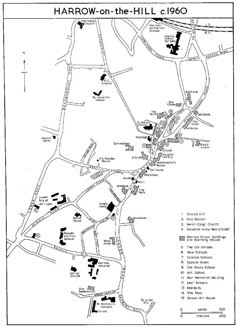
HARROW-on-the-HILL c1960
The principal common fields lay in a block north and west of Roxeth hamlet. (fn. 682) Newden or Newton Field, mentioned in 1507-8, (fn. 683) was in the north and consisted in 1547 (fn. 684) of 225 selions in nine furlongs. South-west of Newden Field lay Mead or Middle Field, which was mentioned in 1456, (fn. 685) and which in 1547 (fn. 686) contained 188 selions in seven furlongs and another furlong which belonged exclusively to Roxeth manor farm. The southernmost field was Dobbs or Dabbs, mentioned in 1383, (fn. 687) which was divided from Ruislip common fields by Bourne Lane. In 1547 (fn. 688) it had 11 furlongs and 263 selions. Blackhall Field, which occurs from the 14th to the 16th century, may be the later Newden Field, since in 1456 land in Blackhall Field was described as at 'Newedenhacche' and in 1553 Newden Field was described as lying at Blackhall cross. (fn. 689) There was a second field system attached to the dependent hamlet of Hyde End, in north Roxeth. In 1547 (fn. 690) Hill Field, which projected south-eastward from Newden Field, was the main field with 79 selions in five furlongs. Great Peeles Field (fn. 691) had 45 selions in two furlongs, Little Peeles Field had 27 selions in two furlongs, and Six Acres Field had 22 selions in three furlongs. There was some inclosure in the 17th and 18th centuries and in 1629 the manorial court ordered the re-opening of Great and Little Peeles. (fn. 692) All the Hyde End fields, except Hill Field, which was also associated with Pinner, had disappeared by 1817, but there can have been little inclosure of the main open fields, since they still comprised 539 a. (fn. 693)
Wastehold parcels, few of them described, increased from five in 1553 to 18 at the end of the century. (fn. 694) There were 21 parcels by c. 1642 (fn. 695) and in 1681, including two cottages, three houses, six barns, and several orchards. (fn. 696) There were 45 houses in 1664, of which 16 were assessed for hearth tax, but none was very large: John Cannon, a freeholder, had 8 hearths, William Greenhill had 7, and five people had 6 hearths. (fn. 697) In 1672 thirty-nine houses were assessed, including some which had not been chargeable in 1664. (fn. 698) At least four more cottages, a messuage, and two barns seem to have been built between 1681 and 1721. (fn. 699)
By 1759 one main route (Bessborough Road, Lower Road, and Northolt Road) ran from northeast to south-west through the length of Roxeth, linking Pinner and Harrow-on-the-Hill with Northolt and Eastcote. Another ran from Pinner through the open fields to join the Northolt road in a series of branch roads, giving it the appearance on the map of a river delta. (fn. 700) This road, Pinner Lane, later called Rayners Lane, appears to have slightly changed course by 1817. (fn. 701) In 1759 there were seventy-eight buildings, some of them outbuildings, most densely concentrated on the west side of Northolt and Lower Road, between the northernmost branch road and a point just south of the junction with West Street. The 'Three Horse Shoes', licensed from 1751, (fn. 702) stood in the angle of Northolt Road and a branch road, on the line of Stanley Road. On the east side of Northolt Road there were a few buildings at the junction with Roxeth Hill and a few more to the south but none between Roxeth Hill and West Street. To the north there were a few isolated buildings, mainly farms, including Roxborough, Honeybourne's, and Roxeth, on each side of Bessborough Road. Buildings were also concentrated at the southern end of Northolt Road, less densely than at its northern end, and on the western edge of the common and around the southernmost branch road. Two isolated farms, Parker's and Baker's, and another, possibly Eve's, lay on the east side of Northolt Road, but there was nothing along either of the two roads to Pinner. The unifying factor was the Northolt road and the long stretch of Roxeth Green and common, which in 1759 consisted of 77 a. The common had been reduced to 58 a. in 1817, but there is little sign of a corresponding increase in the number of buildings. (fn. 703)
The indistinct boundary with Harrow-on-theHill makes it difficult to estimate the population. The population apparently rose from 609 in 1831 (fn. 704) to 703, living in 147 houses, in 1851, if Roxeth in 1851 is defined as Northolt Road with its extensions, Lower and Bessborough Road, London Hill, and Middle Row. The higher figure of 842 people in 1841 evidently included some of the inhabitants of Harrow Town as living in Roxeth. (fn. 705) Most of the new building had been close to Harrow Town, notably in Middle Row, where 41 houses had been erected since inclosure; a further 7 cottages and a school were built along the east side of Lower Road, backing on Middle Row. (fn. 706) There were 10 farm-houses in 1851-2; in the south-west corner, on either side of Northolt Road were Grove (fn. 707) and Parker's (fn. 708) farms, with Tithe Farm standing by itself in Eastcote Lane; (fn. 709) Roxborough, (fn. 710) Honeybourne's (fn. 711) and Roxeth Farm (fn. 712) were in the north, and a farm and brickworks belonging to Richard Chapman stood on the west of Northolt Road, (fn. 713) with two farms almost opposite. (fn. 714) There were two beershops besides the 'Three Horse Shoes': one, at the corner of Middle Row and London Hill, may have been the 'White Horse', licensed 1873-89, (fn. 715) the other (fn. 716) lay behind the cottages in the corner of Northolt Road and London Hill. There was also a beerhouse attached to Roxeth House, the only large residence. (fn. 717) A few bigger houses had been built by 1865: the Grange, Dudley Lodge, Roxeth Lodge, Pleasant Place, and Ivy Lodge and Dabbshill Lodge in the former openfield area. (fn. 718) New buildings in the 1850s and 1860s (fn. 719) included a gas-works in Northolt Road (fn. 720) and Christ Church in London Hill. (fn. 721)
Roxeth retained its rural character in the later 19th century with 7 farms and some farm cottages. There were 30 shops, many along Middle Row, and, besides the four older public houses, the 'Half Moon', the 'Timber Carriage', and one unnamed beershop (fn. 722) erected partly for migrant haymakers. (fn. 723) In the last third of the century roads and houses were built north-east of Eastcote Lane, and some public buildings and installations appeared: a hospital for infectious diseases and a sewage farm in the north, a cottage hospital in Lower Road, replaced in 1905 by one in Roxeth Hill, a drill hall, and mission hall. (fn. 724) The development was still along the line of the ancient village and on land that had formed Roxeth Common. (fn. 725) With the coming of the railway in the 20th century, however, building began to follow railway lines, and farm-land gave way to housing estates. By the 1930s Roxeth had been swallowed into the new dormitory area of South and West Harrow. Roxeth Farm in Bessborough Road, a twostoried weather-boarded house with a symmetrical front of five bays and a hipped, tiled roof, is the oldest surviving building; with its two timber barns it was probably built c. 1700. Dating from the 19th century are cottages in Middle Row and some larger houses in Bessborough Road, including one now occupied by the Middlesex New Synagogue.
Greenhill, one of the smallest hamlets, lay to the north of Harrow-on-the-Hill. Greenhill first appears as a surname in Harrow parish in 1273-4 (fn. 726) and as a place-name in the 1330s, (fn. 727) although the hamlet may have existed earlier as Norbury. (fn. 728) Greenhill usually was not a separate tithing. (fn. 729) During the Middle Ages there were five head tenements or farms, two hides, one ½-hide, and two virgate holdings. Some consolidation had taken place by 1553, when Henry Greenhill held one hide, and John Greenhill and Henry Finch each held a hide and a virgate. (fn. 730) In 1698 the lands of Finch and Henry Greenhill were still held by their descendants, one of whom, William Greenhill, had been a counsellor at law and secretary to General Monck. (fn. 731) All the estates developed into farms of 90-150 a. The 19thcentury house sometimes called Greenhill Lodge, (fn. 732) in the elbow of Bonnersfield Lane, was probably on the site of a head tenement held by Henry Greenhill, (fn. 733) while one of the Finches' head tenements is probably represented by Hill's house, on the west of Greenhill Lane. (fn. 734) There were also a few estates held from Rectory manor, whose lands, and probably also messuages, lay west and south of the village. (fn. 735)
Five common fields are described in 1547. (fn. 736) West Field, which lay west of the hamlet, joining the Rectory lands on the south, had 24 selions in two furlongs. The main block of open-field land lay east of the hamlet, divided from Weald common fields by the Wealdstone (Weald or Greenhill) Brook. The northernmost was North Field, mentioned in 1399, (fn. 737) which in 1547 had 48 selions in three furlongs. Joining it on the east was East Field, mentioned in 1336, (fn. 738) which had 28 selions in two furlongs. Greenhill Field, which lay to the south-east, contained 105 selions in five furlongs. In the south, joining Kenton, was Bandon Field with 88 selions in seven furlongs. In addition, 22 selions of Church Field, Harrow Weald, were described as belonging to Greenhill. From the 17th century, however, Greenhill's fields were Great, Middle, and Bennet or Bonner Field, (fn. 739) which approximated to North, East and Greenhill, and Bandon Field. (fn. 740) At inclosure they covered 113 a. (fn. 741) There is little evidence of many under-tenants, even after the head tenements had been consolidated and some of the original messuages had presumably decayed. (fn. 742) There was no wastehold until 1629 and then only one parcel, (fn. 743) probably the little cottage held by John Show, which was the only wastehold property in 1681. (fn. 744) In 1664 only six houses were assessed for hearth tax, the two head tenements, Greenhill's and Finch's, having six hearths each. (fn. 745) There is no sign of new building in the 18th century, and some of the 19 buildings marked in 1759 were outhouses. (fn. 746) Greenhill was at that time a small hamlet of modest farms regularly spaced around the 6-acre village green, which had been reduced to 3 a. in 1817. (fn. 747) Through the centre of the hamlet ran Greenhill Lane, part of the north-south route through the Weald, Harrow-on-the-Hill, and Sudbury to London. A second road, Sheepcote or Longshot Lane, (fn. 748) joining Greenhill Lane at the southern edge of the village and running south-westward, probably dated from the formation of Sheepcote Farm. A linking road joined the junction with Sheepcote Lane in 1759 and 1817 but afterwards disappeared. One other road is marked in 1759, a short, crooked road leading eastward. By 1817 as Bonnersfield Lane, it ran along the northern boundary of the demesne lands to the common fields. North of it Dirty Lane ran eastward as another entry to the common fields, while a short road on the west formed another field lane. On the west of Greenhill Lane was Finch's, later Hill's Farm, with three other houses south of it, one of them the Six Bells Inn, first mentioned in 1746 (fn. 749) and after 1775 called the 'Marquis of Granby'. (fn. 750) Opposite the inn lay a farm sometimes called Greenhill Farm. To the east lay the farm soon to become the demesne or Manor Farm, with Greenhill's manor-house and two buildings, possibly cottages. Five cottages east of Greenhill Lane had appeared by 1805 (fn. 751) and by 1841 (fn. 752) there were 28 houses, supporting a population of 151. Eight houses, at least three of them farms, 17 cottages, and one inn, formed a nucleated village of only 141 people in 1851-2, (fn. 753) with four more houses in the corner of Greenhill Lane and Roxborough Lane. Change in the late 19th century was rapid, because of Greenhill's position between two railway stations. St. John's church replaced one farm in 1866, (fn. 754) and development in Roxborough, North Harrow, and Wealdstone engulfed Greenhill between 1870 and 1900. In the next two decades it spread into the surrounding farm-land so that, apart from the road pattern, there was nothing left of the original village.
Norbury.The hamlet of Norbury has not been identified with certainty. Lands there were recorded in deeds of c. 1300. (fn. 755) Abutments included 'the road which goes to Harrow on the west', the meadow of the Rector of Harrow on the south, and a messuage on the north. Most of the land consisted of crofts, but some lay in fields: East Field, West Field, La Breche, and Twelveacres. The transactions chiefly concerned William Aylward, or son of Aylward, his brother Simon, and William Carpenter, all 'of Norbury'. Other people involved were Roger Elys (fn. 756) and John Searle 'of Harrow', William le Knel of Headstone, and Roger Frowyk, goldsmith, of London.
Norbury probably stood in some relation to Sudbury, either as the 'north (i.e. Rectory) manor' or as 'north of the town', presumably Harrowon-the-Hill. (fn. 757) All the land was held of the capital fee of the lord, but there is no indication which lord, while mention of a road to Harrow excludes any identification with Harrow-on-the-Hill itself. The land probably lay north of Harrow-on-the-Hill, between Roxborough Lane (later Pinner Road) on the west, the rectory estate on the south, Headstone on the north, and Greenhill on the east. The field names are common throughout the parish, but West Field and Twelveacres can be found together just north of the rectory estate. (fn. 758) Next to them was Broad Field, (fn. 759) which in 1645 was described as 'Northberry alias Broadfield'. (fn. 760) This land was held from the Rectory manor, whose court rolls mention selions on Norbury Hill. (fn. 761) The only croft of Norbury which can be located is Fisher's Croft, which lay east of West Field. The evidence suggests that the lost hamlet can be identified with Greenhill, and certainly land in West Field and Norbury alias Broad Field later belonged to copyholds of Rectory manor in west Greenhill. (fn. 762) Other possible sites for Norbury are Hooking Green in south Pinner, the only common in Harrow without a settlement, or Headstone, which lay north of the land in question but is mentioned by name in the same documents. Norbury was probably a very small hamlet at or near the site of the hamlet of Greenhill, probably on the west side of Greenhill Lane, with its fields lying north of the ancient glebeland and stretching towards Headstone. Possibly it lost some fields when Headstone became a demesne manor, (fn. 763) and the name Norbury (fn. 764) was superseded by Greenhill, the name of the leading local family. (fn. 765)