A History of the County of Middlesex: Volume 6, Friern Barnet, Finchley, Hornsey With Highgate. Originally published by Victoria County History, London, 1980.
This free content was digitised by double rekeying. All rights reserved.
A P Baggs, Diane K Bolton, M A Hicks, R B Pugh, 'Hornsey, including Highgate: Communications', in A History of the County of Middlesex: Volume 6, Friern Barnet, Finchley, Hornsey With Highgate, ed. T F T Baker, C R Elrington (London, 1980), British History Online https://www.british-history.ac.uk/vch/middx/vol6/pp103-107 [accessed 30 April 2025].
A P Baggs, Diane K Bolton, M A Hicks, R B Pugh, 'Hornsey, including Highgate: Communications', in A History of the County of Middlesex: Volume 6, Friern Barnet, Finchley, Hornsey With Highgate. Edited by T F T Baker, C R Elrington (London, 1980), British History Online, accessed April 30, 2025, https://www.british-history.ac.uk/vch/middx/vol6/pp103-107.
A P Baggs, Diane K Bolton, M A Hicks, R B Pugh. "Hornsey, including Highgate: Communications". A History of the County of Middlesex: Volume 6, Friern Barnet, Finchley, Hornsey With Highgate. Ed. T F T Baker, C R Elrington (London, 1980), British History Online. Web. 30 April 2025. https://www.british-history.ac.uk/vch/middx/vol6/pp103-107.
Communications.
The hills of Hornsey obstructed communication to north and south until the late 19th century. None of the main Roman roads out of London passed through the parish but by the early Middle Ages it straddled the Great North Road. According to Norden, (fn. 1) the main road had formerly entered the parish south of Crouch End and run north-north-westward through Muswell Hill to Colney Hatch, but because it was so bad had been moved farther west to ascend Highgate Hill and cross the park of the bishop of London. The bishop was charging a toll in 1318. (fn. 2) By 1354 there was a road from Highgate to Finchley, and Highgate was so called, presumably from the hill-top gate at which the tolls were paid. (fn. 3) The road from the foot of Highgate Hill was part of the main highway north by 1380, when the inhabitants of Islington and St. Pancras were granted pavage to repair it, (fn. 4) as they had been several times before. (fn. 5) Pavage was granted for the stretch from Highgate to Finchley in 1354 (fn. 6) and the road was later maintained by the hermits of Highgate. (fn. 7) In 1526-7 the bishop spent money on the road (fn. 8) and in 1558 it was called the bishop's highway. (fn. 9) Responsibility had devolved on the tenants of Hornsey manor by 1577, when they were ordered to repair the road. (fn. 10)
The road from Highgate northward passed to a turnpike trust, later the Highgate and Whetstone turnpike trust, in 1754 and was of high standard after 1810. (fn. 11) The road up Highgate Hill itself was unsatisfactory: the arch of the Gatehouse obstructed traffic, (fn. 12) the tolls were difficult to collect, (fn. 13) and the gradient was so steep that it caused accidents. (fn. 14) In 1798 it was estimated that an extra horse per team was needed to ascend the hill. (fn. 15)
It was the steepness of the road, rather than the tolls or the negligible saving in distance, (fn. 16) which led in 1809 to a project for a tunnel from Upper Holloway through which traffic would be diverted east and north of Highgate. Work by the Archway Road Co. was authorized in 1810 (fn. 17) and after the collapse of the tunnel in 1812 the company built Archway Road in a deep cutting in 1813. Hornsey Lane crossed it on a bridge 36 ft. high and the old route was rejoined at the Wellington inn. (fn. 18) Although tolls were more expensive than on the old road, (fn. 19) Archway Road was regarded as the only tolerable route northward. (fn. 20) It was little used by natives of Hornsey, Finchley, and Friern Barnet, who outnumbered all other users of Highgate Hill in 1846, doubtless because they were exempt from toll. (fn. 21) The tolls on Archway Road were unpopular (fn. 22) and in 1865 were possibly a deterrent to traffic. (fn. 23) Tolls on both roads were abolished in 1876 (fn. 24) and by 1884 use of Archway Road had increased enormously. (fn. 25) The Archway itself, railed from 1885 to deter suicides, (fn. 26) was replaced by a wider iron bridge on which work began in 1897 and which was officially opened in 1900. (fn. 27) Traffic in Archway Road increased steadily and from the 1920s there were various schemes, which aroused widespread local opposition and resulted in a major widening in the early 1970s. (fn. 28) Further works were the subject of an inquiry involving much controversy in 1977, (fn. 29) when rush-hour conditions were very bad and many frontages along Archway Road were decaying.
Apart from the road through Hornsey park there were three north-south routes. Green Lanes, which extended along the whole eastern edge of the parish towards Bush Hill, Enfield, was turnpiked in 1789 in spite of Hornsey's opposition. (fn. 30) At Clissold Park it diverged from Norden's old north road, of which the stretches northward to Crouch End are called Mountgrove Road (Gipsy Lane in 1872), (fn. 31) Blackstock Road (still called Boarded River Lane in 1849), (fn. 32) Stroud Green Road, and Crouch Hill, which together were known as Tallingdon Lane between 1593 and 1795. (fn. 33) In 1795 Tallingdon Lane had only recently been a rough track, (fn. 34) which Blackstock Road remained in 1832, (fn. 35) and in 1850 the railway was built across it. North of Crouch End, Park Road (called Maynard Street from at least 1503 until 1854) (fn. 36) led to Muswell Hill, whence Colney Hatch Lane (Hollick or Halliwick Street or Lane 1359-1815 and Muswell Hill Lane by 1814) (fn. 37) ran into Friern Barnet parish. Highgate was connected to Muswell Hill by Muswell Hill Road (the northern stretch of Southwood Lane from 1604 to 1898). (fn. 38) Coppetts Road, from Fortis Green via Irish Corner (fn. 39) to Colney Hatch, existed as a track in 1754. (fn. 40)
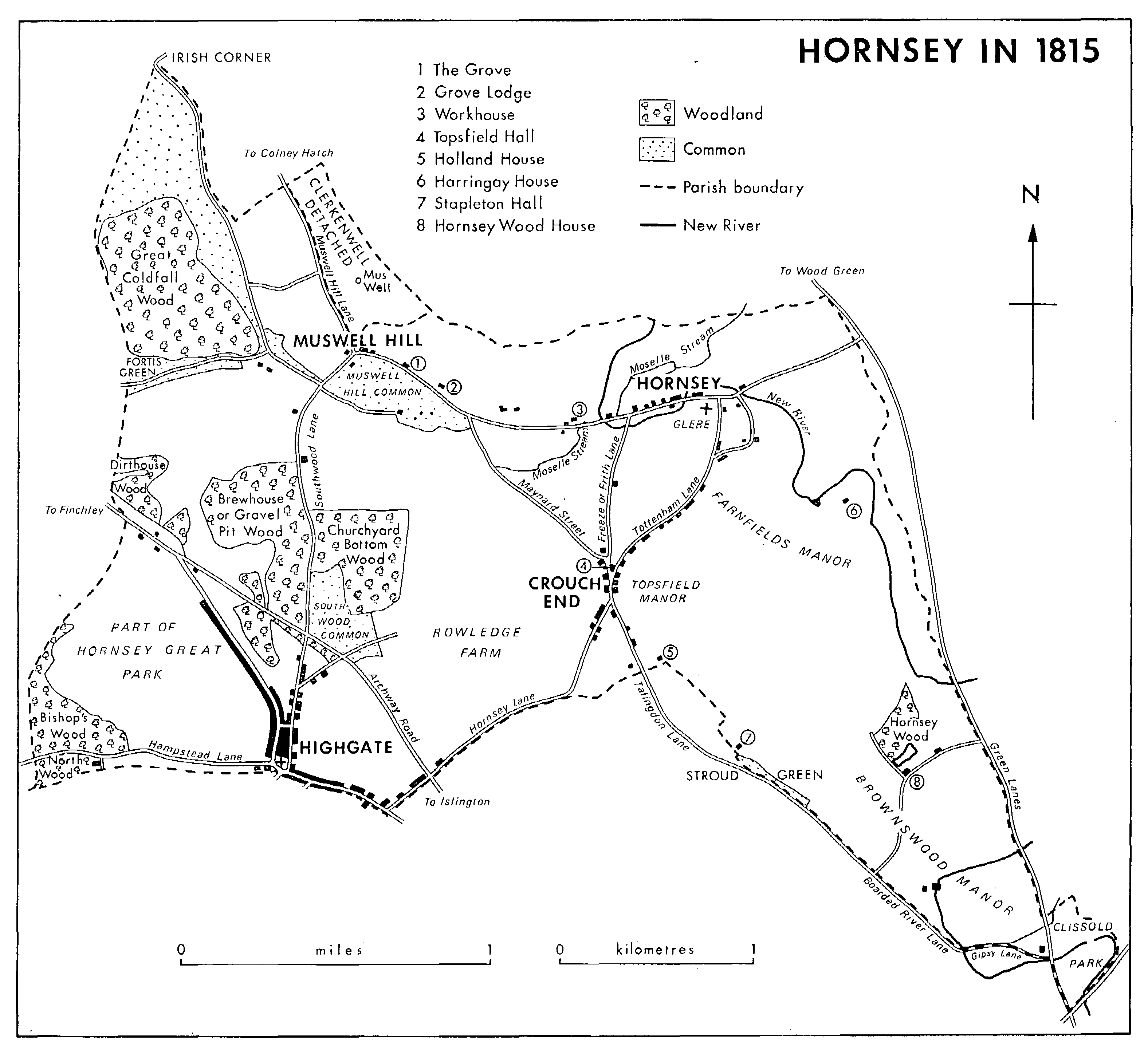
HORNSEY IN 1815
East-west communication was provided in the north by the road from Tottenham to Muswell Hill, later called in its various parts Turnpike Lane (Tottenham Lane in 1863), High Street, and Priory Road. From Muswell Hill, Fortis Green ran westward into Finchley. Along the southern boundary Hampstead Lane connected Hampstead and Highgate, and the latter was linked to Crouch End by Hornsey Lane, so called in 1604, (fn. 41) and Crouch End Hill (1619). (fn. 42) Other local roads included Tottenham Lane and Middle Lane (Frith or Freeze Lane from 1503 until 1810) (fn. 43) between Crouch End and the two ends of Hornsey High Street, Wood Lane which ran from Stroud Green Road to Green Lanes by 1577, (fn. 44) and Page's Lane, leading westward from Colney Hatch Lane and called in turn Jones's (1611) and Red House Lane. (fn. 45) In addition there were a few paths, notably Church Path from Tottenham Lane to Hornsey church, and various lanes were created leading to allotments under the inclosure award of 1815. The road system already existed by the 16th century. (fn. 46) Efforts to close the footpaths by the G.N.R., the Archway Road Co., and the New River Co. were vigorously resisted in the 1850s by the vestry's footpaths committee. (fn. 47)
In 1832 Seven Sisters turnpike road was built from Islington in a north-easterly direction across Stroud Green Road and Green Lanes; (fn. 48) it replaced Wood Lane c. 1866. (fn. 49) Some of the new streets built in the 19th century were important lines of communication: Endymion Road, built c. 1875 under the Finsbury Park Act of 1857, connected Stroud Green and Green Lanes north of Finsbury Park; (fn. 50) Ferme Park Road, c. 1885, joined Tottenham Lane and Stroud Green; (fn. 51) Shepherd's Hill and Wolseley roads were built by 1886 between Highgate and Crouch End; (fn. 52) Wood Lane, Highgate, was extended as Queenswood Road through Queen's wood to Park Road after 1896, and Wightman Road of c. 1885, parallel to Green Lanes, was intended as a major thoroughfare between Endymion Road and Turnpike Lane. (fn. 53) The northern tip of Hornsey touches the North Circular Road (1929). Within the parish communication is impeded by the railways, even those that are no longer in use; there is only one road-bridge over the main line between Stroud Green Road and Turnpike Lane.
In the 14th century Hornsey's roads were said to be impassable in winter, (fn. 54) although the Great North Road was maintained from pavage and bequests. (fn. 55) There were legacies towards Brokhersthill (perhaps Crouch Hill), (fn. 56) the way from Highgate to St. Mary's church, and other local byways. (fn. 57) Statute duty was often neglected in the 17th and 18th centuries, particularly in the period 1679 to 1686, (fn. 58) and in 1792 another attempt was made to exact labour rather than compositions. (fn. 59) Roads across the waste were liable to excavation, (fn. 60) especially in the 17th century, and in 1815 most of the roads were broad and ill defined. (fn. 61) The pond on top of Muswell Hill, which was a danger to travellers in 1820, (fn. 62) was filled in only in 1858, when the gradient was reduced, (fn. 63) and a large sum was spent in 1824 to make safe the Bank at Highgate. (fn. 64)
Maintenance also suffered because Hornsey shared the responsibility for many of its far-flung roads. Repairs to Stroud Green Road, remembered as bad in 1593, (fn. 65) or Hornsey Lane, the subject of indictments in 1736 and 1746, (fn. 66) were a frequent cause of dispute with Islington. (fn. 67) The part of Colney Hatch Lane bordering Clerkenwell detached was in disrepair in 1359 and 1399, when responsibility rested with the prioress of Clerkenwell. (fn. 68) Although Hornsey had never contributed to its repair before 1778, (fn. 69) the two parishes agreed in 1835 that each should maintain a stretch. (fn. 70) After long neglect the Clerkenwell section was repaired before 1891 but it remained bad (fn. 71) and in 1899 the whole road became Hornsey's responsibility. The roads dividing Hornsey detached from Islington, Stoke Newington, and Hackney were also disputed. (fn. 72) As Hornsey local board was uninterested in the repair or lighting of Seven Sisters Road (toll free from 1872), the boundary with South Hornsey was moved from the centre to the northern side of the road in 1874. (fn. 73)
Green Lanes in 1577 crossed Stroud Green brook by Stone, White, or Maiden bridge, (fn. 74) and the road between Crouch End and Muswell Hill crossed the Moselle in 1668 by two footbridges and two cart-bridges. (fn. 75) Under the Great North Road, Mutton brook was culverted by 1826, when the Moselle also ran through culverts.
The coaches on the Great North Road which called at Highgate daily in the 18th century (fn. 76) were little used by local people. In 1816 three coaches ran to Holloway, Crouch End, Hornsey, and Muswell Hill from London and back daily but the earliest time of departure from Muswell Hill was 9 a.m. (fn. 77) In 1825 four coaches from Highgate and four from Hornsey made respectively ten and eight journeys to London every day. (fn. 78) In 1834 four coaches daily left the Globe, Moorgate Street, for Hornsey and three from Newgate and Tottenham Court Road for Highgate, but none was advertised to leave earlier than 11 a.m. (fn. 79)
In 1838-9 two omnibuses and a short-stage coach from Highgate and three omnibuses from Hornsey ran to the City daily. (fn. 80) By 1845 there was a regular service of nine omnibuses, the first leaving Highgate at 8.30 a.m. (fn. 81) Watkin's omnibuses conveyed people daily to their offices c. 1862, (fn. 82) by which date the Archway taven at the foot of Highgate Hill had become the terminus for omnibuses from several parts of London. (fn. 83) In Southwood Lane in the 1870s Mary Kingsley observed palefaced men with black bags passing morning and evening on their way to and from the City. (fn. 84) Hornsey village was served in 1845 by Baker's omnibuses and by Wilson's from Muswell Hill. (fn. 85) None the less the recommended way from London to Muswell Hill in 1846 was by the Finchley stage or omnibus and thence by cab. (fn. 86) Travellers from Fortis Green still depended on the Barnet mail omnibus along Finchley High Road in 1856. (fn. 87) In the 1840s the relatively few residents of Muswell Hill who worked daily in the City still travelled by four-horse carriage. (fn. 88) In the period 1851-5 the only omnibus between Hornsey and the City was that of Vass and Rogers, later of Rogers alone. (fn. 89) By 1862 it was no longer running owing to competition from the trains, although Wilson's omnibuses provided a ten-minute service from the Hanley Arms, Hornsey Road, Islington, until 1870 (fn. 90) and others were running by 1874 from the Duke of St. Albans, Highgate Rise, (fn. 91) also just south of the parish.
The most important of the early railways in the parish was the Great Northern Railway, opened from Maiden Lane in 1850 (from King's Cross in 1852), with Hornsey as the first station from London. (fn. 92) Seven Sisters Road station, renamed Finsbury Park in 1869 and rebuilt in the 1870s, was opened in 1861 just across the boundary with Islington, (fn. 93) and a station at Harringay (West) in 1885. (fn. 94) Hornsey station was re-sited in 1866, when the old lines became sidings (fn. 95) and there were 16 trains a day to the City. (fn. 96) In 1875 the North London Railway started a service to and from Broad Street. (fn. 97) There were 54 trains a day from Hornsey to the City in 1885, (fn. 98) when they were very crowded during rush-hours, (fn. 99) and in 1904 the holders of season-tickets using the station each day numbered 3,500. (fn. 100) By 1884 there were cheap fares on workmen's trains. (fn. 101)
Under an Act of 1862 the Edgware, Highgate & London Railway Co., part of the G.N.R. from 1866, (fn. 102) opened a line from Finsbury Park to East Finchley, with stations at Crouch End and Highgate, in 1867. (fn. 103) Stroud Green station was opened in Stapleton Hall Road in 1881. (fn. 104) A branch line linked Highgate and the Alexandra Palace in 1873, was closed after the destruction of the palace in the same year, reopened in 1875 with a new station at Muswell Hill, and closed for varying periods on several occasions up to 1952. Cranley Gardens station, on the corner of Woodside Avenue and Muswell Hill Road, was opened in 1902. (fn. 105) In 1954 the whole of the line from Finsbury Park to Highgate and beyond was closed to passenger traffic; freight services continued to Muswell Hill until 1956 and to Highgate and Finchley until 1964, the track to the Alexandra Palace being taken up in 1958 and to Highgate in 1970.
From 1868 the Great Eastern Railway, and from 1870 the Midland Railway, ran passenger services to Fenchurch Street station along the Tottenham and Hampstead Junction Railway. There were stations called Crouch Hill from 1870 and at South Harringay, called Harringay Park (later Stadium), from 1880, each just outside Hornsey parish. (fn. 106) Although season-tickets to London were relatively cheap, (fn. 107) the line was more important as a link between the G.E.R. and the Midland Railway than as a commuters' route. (fn. 108)
An Underground line from Finsbury Park to Moorgate was built in 1904 by the Great Northern & City Railway Co.; it was taken over in 1913 by the Metropolitan Railway and in 1933 by the London Passenger Transport Board, becoming part of the Northern line in 1939, and was converted in 1975-6 for use by British Rail. (fn. 109) What was later part of the L.P.T.B.'s Piccadilly line began in 1906 as the Great Northern, Piccadilly and Brompton Railway, was taken over by the London Electric Railway in 1910, and was extended to Arnos Grove in 1932, with stations close to the Hornsey boundary at Manor House and Turnpike Lane. (fn. 110) London Transport's Victoria line added another Underground route through Finsbury Park in 1968. (fn. 111)
What later became a part of the Northern line of the London Underground was opened in 1907 by the Charing Cross, Euston & Hampstead Railway Co. as a branch to Archway station (formerly called Highgate) at the bottom of Highgate Hill. It was absorbed by the L.E.R. in 1910 and by the L.P.T.B. in 1933, and was extended to Highgate, where a station was completed in 1941 beneath that of the G.N.R., and along the old G.N.R. tracks, converted for Underground use, to East Finchley. (fn. 112)
The North Metropolitan Tramways Co. began services from Moorgate to Finsbury Park and Green Lanes in 1872; (fn. 113) trams along Seven Sisters Road from 1885 provided a link with the line from London to Edmonton, and from 1887 the North London Tramways Co. also ran trams to Wood Green. (fn. 114) In 1905 the M.E.T. opened a route from Turnpike Lane via Hornsey High Street to the Alexandra Palace. (fn. 115) From the Archway tavern, linked by trams with the City by 1873 and with the west end of London by 1882, (fn. 116) a cable tramway, the first of its type, was taken up Highgate Hill in 1884, (fn. 117) making Highgate wood readily accessible. (fn. 118) The cable tramway was out of use from 1892 to 1897 (fn. 119) and in disrepair in 1906-7, suffering from competition from the M.E.T.'s electric trams along Archway Road, started in 1905. (fn. 120) The cable tramway was closed in 1909 and reopened as an electric tramway in 1910. (fn. 121) Trolleybuses replaced tramcars in Archway Road and between the Alexandra Palace and Turnpike Lane in 1938, (fn. 122) but were withdrawn in the 1950s, as were the tramcars south from Manor House. (fn. 123)
Motor-buses were running from Muswell Hill to Finsbury Park in 1914 and 1926, and to Tottenham Hale via Crouch End in 1926. (fn. 124) In 1958 there were eleven motor-bus routes through the body of the parish and eight serving outlying parts. (fn. 125)