A History of the County of Middlesex: Volume 6, Friern Barnet, Finchley, Hornsey With Highgate. Originally published by Victoria County History, London, 1980.
This free content was digitised by double rekeying. All rights reserved.
'Hornsey, including Highgate: Growth from the mid 19th century', in A History of the County of Middlesex: Volume 6, Friern Barnet, Finchley, Hornsey With Highgate, (London, 1980) pp. 111-122. British History Online https://www.british-history.ac.uk/vch/middx/vol6/pp111-122 [accessed 25 April 2024]
Growth from the mid 19th century. (fn. 1)
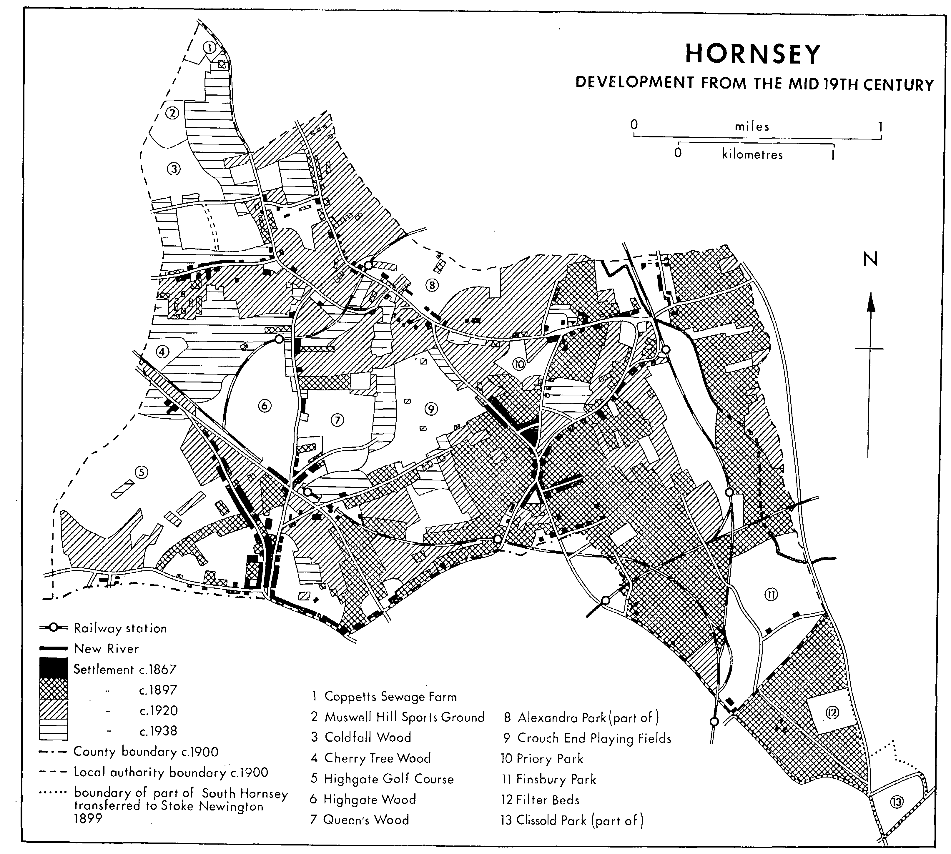
Modern Hornsey dates from the late 19th century. New building at first was confined to existing centres and was slow, perhaps partly because of poor sewerage, (fn. 2) until the 1860s. Country houses were being built until the 1880s but growth was such in 1875 that the 1871 census was no longer a reliable guide to population. (fn. 3) In the south part Brownswood Park was built up in the 1860s and 1870s and Stroud Green, begun in the 1860s, was almost complete in the 1870s. Harringay was a product of the 1880s, while Ferme Park and the Crouch Hall estate were partly built up by 1894. Eastern Hornsey and northern Crouch End were built up more slowly and western Hornsey, Muswell Hill, and Fortis Green had been little altered by 1891.
Attempts were made to establish select suburbs at Brownswood Park, Shepherd's Hill, and Muswell Hill, so that in 1904 Hornsey could be extravagantly compared with Kensington as North London's west end. (fn. 4) Elsewhere builders provided terraced and semi-detached houses for the poorer whitecollared workers. The lack of local employment excluded the working class, except for domestic servants: in 1901 there were 7,852 people in service, of whom 6,598 worked indoors, 6,548 being female, and there were still 7,217 in 1931. (fn. 5) Hornsey attracted men from the metropolitan parishes who worked in the City (fn. 6) and in 1901 11 per cent of the population were clerks, (fn. 7) who needed to live near railway stations. Access to London was emphasized, as early as 1867 it was assumed that most men travelled thither by the G.N.R., (fn. 8) and in 1886 Hornsey's seven stations were considered sufficient explanation for its expansion. (fn. 9) After 1873, when trains were running to all parts of the parish, building depended mainly on the availability of land. At Hornsey and Crouch End building was thwarted for decades by private landowners and Harringay's rapid growth took place only on the sale of a large estate. In the west the vast property of the Ecclesiastical Commissioners was not on the market until relatively late and much of it was preserved for recreation. The establishment of Finsbury Park as an open space ensured that Brownswood evolved independently from the rest of Hornsey. The high proportion of parkland partly explains why 'Healthy Hornsey' had the lowest death-rate on record in 1905 and the lowest of all large towns in 1906. (fn. 10) In 1906-7 the density of population was only 30.2 people per acre. (fn. 11)
The first public open spaces were Finsbury Park, opened in 1869, Highgate wood, opened in 1886, and Clissold and Waterlow parks, opened respectively in 1889 and 1891. All passed to the L.C.C. except Highgate wood, which remained with the City of London, and from 1899 Clissold Park lay within Stoke Newington. (fn. 12) Crouch End playing fields, bordering Park Road, were leased from the Ecclesiastical Commissioners by a company formed in 1892. Originally 18 a., (fn. 13) they covered c. 40 a. by 1926 (fn. 14) and 53 a., mostly serving private clubs, by 1956. (fn. 15) Hornsey recreation grounds originated in a plot of wasteland opposite the Rectory, acquired by the local board in 1887, and in c. 8 a. along Middle Lane, which were to be laid out as gardens in 1894. (fn. 16) A field beside Priory Road was also acquired in 1921-2 (fn. 17) and, with a further 9 a. acquired in 1926, formed Priory Park. (fn. 18) Queen's wood, an eastern extension of Highgate wood, was so named on its acquisition by Hornsey U.D. in 1898. (fn. 19) By 1918 over 460 a. or 16 per cent of the borough consisted of open spaces; they included 17 a. of allotments, Highgate golf course, and 38 a. of Alexandra Park. (fn. 20) Coldfall wood was added in 1934 (fn. 21) and on the north bordered Muswell Hill sports ground, a reclaimed rubbish tip, from 1962. (fn. 22)
Muswell Hill and Fortis Green were affected by the G.N.R.'s stations at Finchley (1867) and Muswell Hill (1872) and by the opening of Alexandra Park in 1872. The Alexandra Palace's workforce, however, was housed in Friern Barnet (fn. 23) and few visitors to the palace chose to settle. Near the western end of Fortis Green was the Woodlands, erected regardless of expense c. 1863 for Frederic Lehmann and visited by many leading literary and musical figures. (fn. 24) At Fortis Green 20 houses were built in the decade to 1861, (fn. 25) most of them probably on the estate south of the road acquired in 1852 by the National Freehold Land Society and called Haswell Park. Intended for superior villas, (fn. 26) it was divided into 180 plots facing Eastern, Western, and Southern roads and the paths later called Haswell Passage, Francis Road, and Shakespeare Gardens. (fn. 27) Some roads existed by 1855 (fn. 28) and in 1856 it was claimed that all lots were fenced and connected to main services. (fn. 29) In spite of auctions in 1852 and 1856 (fn. 30) some lots were unsold in 1858; (fn. 31) there were only 28 houses in 1871, (fn. 32) vacant plots remained in 1896, and the southern part of the estate was never built on. The delay in building may have stemmed from poor communications via Finchley High Road. (fn. 33) In 1871 twelve houses, six built during 1867-8, stood north of Fortis Green (fn. 34) and in 1896 two large houses alone lay between Eastern and Muswell Hill roads. Building had spread up both sides of Tetherdown since 1871, (fn. 35) when eight houses stood in Page's Lane. (fn. 36)
HORNSEY
Development from the mid 19th century
At Muswell Hill itself Bath House and the Grove made way for Muswell Hill station, (fn. 37) and a threestoreyed terrace was erected facing the road by the Imperial Property Investment Co. as its Grove House estate. (fn. 38) Farther down the hill Grove Lodge was rebuilt in 1854 as a large two-storeyed stuccoed house. (fn. 39) The number of houses in Colney Hatch Lane grew slowly and in 1871 most were large detached villas like Carisbrooke Cottage, built by 1861, Wood Villa, Milford Lodge, and Laurel Bank Cottage. (fn. 40) In Clerkenwell detached 12 a. were laid out in small plots for building c. 1878. Two plots facing the main road were built on and four more houses were never finished. (fn. 41) It was probably on the same estate that c. 1879 plots were bought cheaply by people who squatted rate free in shanties until at least 1888. (fn. 42) Not all the 12 a. of c. 1878 had faced Colney Hatch Lane. About the same time land formerly part of Alexandra Park and stretching eastward into Wood Green was acquired by the London Financial Association. In 1884 Muswell Avenue and Muswell and Coniston roads had been laid out and the last 125 lots west of Muswell Avenue were auctioned. Only two houses had been erected and the company evidently had difficulty in selling plots. (fn. 43) In 1891 only 54 houses with 318 residents stood in Clerkenwell parish (fn. 44) and little change had occurred by 1896. Muswell Hill was still a place where the rich built seats. (fn. 45)
At Hornsey village, after the opening of Hornsey station, building in the late 1860s was proceeding as rapidly as land became available. By 1861 the village had spread east of the railway over the former Cocksfields. (fn. 46) In 1861 sixteen houses stood in Clarendon Road, where the gas-works was moved in 1867, and the first house fronting Turnpike Lane itself was let in 1860. (fn. 47) The Hornsey Park estate, which by 1881 comprised the later Hornsey Park, Alexandra, Ravenstone, and Brook roads, Malvern Parade, Park Ridings, and the Avenue in Hornsey and Tottenham, (fn. 48) was being laid out by 1869; (fn. 49) in 1879 it belonged to the Imperial Property Investment Co. (fn. 50) Six-roomed houses there were selling well in 1880, (fn. 51) and by 1896 the whole district was built over; Turnpike Lane was coming to be a major thoroughfare in the 1880s but even in 1900 it contained only 30-40 houses. (fn. 52) West of the G.N.R. the Birkbeck Freehold Land Co. had acquired the Grove House estate, on the corner of Middle Lane and High Street, by 1866 and had built up the frontages to Middle Lane and the new Grove House and Birkbeck roads. (fn. 53) The estate had been bounded on three sides in 1855 by the land of John Holland, which adjoined the Three Compasses inn. (fn. 54) In 1865 the National Freehold Land Society acquired his estate (fn. 55) on which Haringey, Lightfoot, St. Mary's, Westfield, Rectory, and Holland roads were constructed. By 1870 street lighting could be supplied to St. Mary's estate, perhaps the area known as Lister Park between High Street and Church and Tottenham lanes. (fn. 56) Campsbourne Lodge and 24 a. north of High Street were acquired in 1866 by the British Land Co., (fn. 57) which laid out the Campsbourne estate of small terraced and semi-detached houses in the Campsbourne and in Newlands, Campsbourne, Boyton, and Myddelton roads. By 1871 1,294 houses, more than a quarter of them uninhabited, had been built at Hornsey, 117 were under construction, and the population had risen to 3,116. (fn. 58)
Despite near-by building the village had changed little in 1876 when viewed from High Street, which remained broad and tree-lined; (fn. 59) nothing had been built west of the Rectory and Middle Lane or south of the church on the glebe, which the rector refused to sell. Although he had started leasing land by 1881, (fn. 60) the glebe was only partly built up in 1896, when Middle Lane still marked the eastern limit of building. Farther south growth was halted by the grounds of the new Rokesley House, Hermiston Lodge, and Elm House. (fn. 61) In 1887 builders could not obtain freehold sites because all were held by one proprietor. (fn. 62) In Hornsey village there were 62 people to the acre in 1906-7. (fn. 63)
At Crouch End, where building strained the sewerage system, Christ Church replaced the smaller Broadway chapel in 1862 but itself needed a new aisle by 1866. (fn. 64) Both villas and labourers' cottages sprang up. In 1856 there were already 156 houses in Park Road, 29 in New Road, and 5 in Middle Lane. (fn. 65) Park Villas and Park Terrace, on either side of Park Road, and Richmond Villas, west of Middle Lane, extended north of New Road by 1871. (fn. 66) The ribbon of housing stretched little farther north in 1896, when it was barred by the Chestnuts in Middle Lane, but substantial terraces extended as far as Palace Road. As early as 1869 houses had been erected in the Grove (fn. 67) and 57 cottages had been built by Thomas Beall in the Grove, Willow Walk, and Park Road. (fn. 68) West of Tottenham Lane, north of the Topsfield Hall estate, the road was lined with shops and cottages as far as Holy Innocents' church (1877). (fn. 69) Likewise Crouch End Hill, where Christ Church stood by itself in 1869, was lined on both sides with humble shops of brick or weatherboard with mansard roofs as far as the church c. 1885. (fn. 70) Nevertheless Crouch End was still a pleasant, even rural, place in 1876. (fn. 71) Well-spaced houses extended along the eastern side of Tottenham Lane through Crouch End and up Crouch Hill, the newer ones in Crouch Hill including Amedee Villa, home of Ambrose Heal, and Cecile House. (fn. 72) At the summit but standing back from the road in 2 a. was Womersley House, apparently built for the London draper Peter Robinson, who lived there in 1871. (fn. 73) At right angles to Crouch Hill, Haringey Park had been laid out by 1855, with 15 large houses in 1861 and 25 in 1871. (fn. 74) Another large houses, the Limes, stood by 1869 at the top of Crouch End Hill opposite Crouch End station. The opening of the station had contributed by 1871 to the transformation of Hornsey Lane, where 21 detached houses joined Hornsey Lane Farm, and to the construction of Crescent Road. (fn. 75)
In 1855 the Ecclesiastical Commissioners obtained possession of 156 a. of the Brownswood demesne. Bounded by Seven Sisters and Blackstock roads and by Green Lanes and wholly undeveloped, the land's accessibility from London made it ideal for building. The road system had been decided by 1861 (fn. 76) and plots were let to individual builders. John Brookes Porter, later chairman of South Hornsey local board (fn. 77) and a bankrupt, built the earliest houses from 1862. Most of the frontages of Seven Sisters Road and Green Lanes were built up in the 1860s, the bulk of Queen's Road (later Drive) and King's Road (later Crescent) were completed by 1871, (fn. 78) and the remainder of the estate, except for Prince's (later Princess) Road, was built up in the 1870s. Green Lanes and Brownswood and King's Road were to contain detached or semidetached houses and Queen's Road was to have terraces or semi-detached houses, but the builders were more lavish. Stressing the good communications and rural setting, Porter advertised fourstoreyed terraced houses in both Queen's and King's roads; (fn. 79) houses in Green Lanes and Seven Sisters Road were even larger. Brownswood Park, as the district was called, was regarded as a particularly good part of a select suburb. (fn. 80) The copyhold land on the east became the Sluice-House estate, (fn. 81) with similar houses built, for the most part, by the same men. The first houses were completed in 1869 and at least 84 were ready in 1873. (fn. 82) In 1894, when the area had been built up for five years, there were 1,077 houses with 7,359 inhabitants in the 164 a. of Brownswood Park. (fn. 83)
Stapleton Hall was the only house in Hornsey between Crouch End and Seven Sisters Road as late as 1861 (fn. 84) but the streets of Islington were approaching Stroud Green Road, along the east side of which stood several large houses. Rapid growth followed the opening of Seven Sisters, Crouch Hill, and Crouch End stations. In 1863 Joseph Lucas of Stapleton Hall leased land for building (fn. 85) and in 1868 Mount Pleasant Road had been built from the corner of Stapleton Hall and Stroud Green roads over the T. & H.J.R. (fn. 86) to meet Mountview Road, which already crossed the railway farther north. There were 25 houses in Mount Pleasant Road in 1871. (fn. 87) Stapleton Hall Road had been laid out by 1876 and Ferme Park Road was driven over the ridge towards Tottenham Lane in 1880. (fn. 88) To the south the grid of streets was already planned in 1868 (fn. 89) and Osborne and Albert roads and Upper Tollington Park contained 49 houses in 1871, (fn. 90) by which time the roads in the angle of Stroud Green Road and the G.N.R. were largely built up. (fn. 91) In the 1870s they were considered to be in the illdefined area called Finsbury Park, which included Brownswood Park and parts of Islington. By 1877 Finsbury Park was a growing neighbourhood (fn. 92) with a strong community feeling and its own newspaper (fn. 93) and was inhabited mainly by commuters with third- and second-class season tickets. (fn. 94)
When Hornsey was divided into wards in 1894 the southern part became Finsbury Park ward and the area farther north Stroud Green ward. Endymion, Lothair, and adjoining roads carved out of the park were completed in 1885 by the British Land Co. (fn. 95) All roads south of the ridge existed by 1880, (fn. 96) when Holy Trinity church was consecrated. Building continued as late as 1893 in Stapleton Hall Road (fn. 97) and in 1896 the area was virtually built up.
From 1840 (fn. 98) the whole area between Green Lanes, Turnpike Lane, the G.N.R., and the T. & H.J.R., in both Hornsey and Tottenham, was attached to Harringay House. The land was undulating, wooded, and crossed by the meandering New River. (fn. 99) Both north of Turnpike Lane and south of the T. & H.J.R. sites were prepared by the British Land Co., which bought the whole estate during 1880-1. (fn. 100) The land was laid out on a grid between Green Lanes and the parallel Wightman Road, with a total of 23 streets, and was divided into Harringay Park estate in the south and Hornsey Station estate in the north. Only half was laid out in 1885 but the first auction of plots in the southern portion had been in 1881 and in the northern part in 1882. Sewerage was difficult because of the contours and the New River had to be diverted into tunnels. Advertising stressed access to London, in particular via Hornsey and Harringay (West) stations, the second of which was provided at the company's insistence. Uniform two-storeyed terraced or semi-detached houses were erected throughout and were inhabited mainly by clerks in 1901. By 1899, when building was completed, there were 1,016 houses in the north part and 1,400 in the south. South Harringay ward had 53 people to the acre in 1906-7 and North Harringay ward, which probably included the area north of Turnpike Lane, had 81 per acre. (fn. 101)
After the growth of Stroud Green and Harringay the fields north of the ridge, henceforth called Ferme Park, were soon taken for building. Of the roads across the ridge before 1883 (fn. 102) the most important was Ferme Park Road itself, which had been laid across Farnfields manor from Tottenham Lane to Stapleton Hall Road by 1880. (fn. 103) By 1884 Weston Park, Bourne, Landrock, and Gladwell roads were laid out between it and the Elder estate to the west and in 1888 plots there were for sale. (fn. 104) Large semi-detached houses in Elder Avenue and Weston Park were ready in 1889 and Cecile Park was constructed by 1892. (fn. 105) Both Cecile and Weston parks were planned by J. Farrer, architect to the Elder family. (fn. 106) The whole district west of Ferme Park Road was built over by 1896 but progress farther east was slower. Hornsey Vale, said to have been the grounds of a house called Abyssinia facing Tottenham Lane, was laid out as Spencer, Gordon, Hanbury, Canon, Abyssinia, Enfield, and Montague roads by 1880, when over 200 terraced houses had been built. (fn. 107) Eastern Weston Park and the whole of Ridge and Oakworth (later Nelson) roads were built by 1884. (fn. 108) Some of Farnfields manor became the Ferme Park estate of the Streatham and Imperial Estate Co. by 1888, when it was selling plots in Nelson Road, (fn. 109) and the eastern part, with the grounds and house of Rathcoole facing Tottenham Lane, formed the Rathcoole estate of J. C. Hill stretching back to Ridge Road. Four three-storeyed shops in Milman Terrace, Tottenham Lane, were built in 1889 (fn. 110) and in 1893 Hill constructed a three-storeyed terrace of shops near the junction with Church Lane. (fn. 111) Altogether he planned 257 houses in Rathcoole Avenue, Rathcoole Gardens, and Harvey and Uplands roads (fn. 112) but few were completed before 1896. Those built were terraced and cheaper than those on the Elder estate. Like Harringay, Stroud Green, and Finsbury Park, Ferme Park mainly housed commuters of moderate means, who were contrasted in 1888 with the richer residents of Shepherd's Hill. (fn. 113)
In 1856 Rowledge farm was divided between the Ecclesiastical Commissioners and C. S. Dickens: Dickens received 121 a. bounded by Shepherd's Hill, Hornsey Lane, Crouch End Hill, and an intended road, perhaps Stanhope Road; the commissioners were assigned 173 a. bounded by Churchyard Bottom wood, Shepherd's Hill, and Park Road. (fn. 114) They also owned Highgate wood, on which they probably hoped to build, (fn. 115) and even after surrendering it in 1885 they planned roads through Churchyard Bottom wood. (fn. 116) From 1870 they leased land for building in Stanhope Road. (fn. 117) Dickens had built large detached houses along Hornsey Lane and the new Crescent Road by 1871 (fn. 118) and had laid out Coolhurst Road from Hornsey Lane to Shepherd's Hill by 1882, when the Imperial Property Investment Co. was his agent. (fn. 119) The company also acted for the commissioners from 1882, (fn. 120) when it acquired the leasehold rights of the Bird family in Crouch Hall, (fn. 121) treating all three estates as one. (fn. 122) On its own behalf the company bought c. 1885 as its Muswell Hill estate Upton farm, consisting of 42 a. bounded by Muswell Hill Road, St. James's Lane, Churchyard Bottom wood, and, in the east, land stretching to Park Road. (fn. 123) By 1896 it had acquired land farther east, called the whole Imperial Park, and apparently planned an integrated road system for over 350 a. Both Crouch End and Highgate were considered good residential areas, which all parties meant to preserve. (fn. 124) Building began in the east part of Coolhurst Road, where twelve roads for 588 houses had been laid out in 1882. (fn. 125) Detached Jacobeanstyle houses in Shepherd's Hill Road, threestoreyed and with nine bedrooms, were advertised c. 1885. In Wolseley, Coleridge, Coolhurst, and Crouch Hall roads smaller two-storeyed Queen Anne-style detached houses were available. (fn. 126) On the Muswell Hill estate three-storeyed eight-bedroomed detached houses were built. (fn. 127) Failure to sell some new houses in 1886 (fn. 128) may partly explain why the company was reconstituted in 1894 and often sought improved terms from the Ecclesiastical Commissioners, (fn. 129) in spite of the district's rural attractions (fn. 130) and convenient railway services. Only the area near Crouch End and a strip of land along Shepherd's Hill Road, together containing 700 houses, (fn. 131) and part of Onslow and Cranley gardens had been built on by 1896. As late as 1920 much of the southern estate was vacant.
During the 1890s building spread over Muswell Hill, Fortis Green, and western Hornsey. The number of inhabited houses rose from 9,712 in 1891 to 12,571 in 1901 and 19,940 in 1911, (fn. 132) giving the parish its modern appearance. The hamlets survived much as they were in 1851 or even 1816 until, during the 1890s, the old centres of Crouch End, Muswell Hill, and, to a lesser extent, Hornsey itself, made way for municipal buildings and shopping parades. Meanwhile estates merged into a continuous suburb that extended into neighbouring parishes. Only a third of Hornsey was built over by 1894 (fn. 133) and it was expected that the population would exceed the level it ultimately reached. Combined with relative prosperity and good public services, such confidence encouraged Hornsey's desire for borough and even county borough status. (fn. 134)
Building activity had slackened by 1914 (fn. 135) in spite of a continuing demand and, by 1923, a shortage of houses. (fn. 136) There was a lack of sites as large areas remained open, notably Muswell Hill north of Creighton Avenue, Highgate wood, and Crouch End playing fields. (fn. 137) No more building was possible in Stroud Green or Harringay between 1901 and 1911, when their populations fell. (fn. 138) The declining size of families, however, (fn. 139) permitted multiple occupation of houses and the provision of blocks of flats, which were associated with lower standards as early as 1900. (fn. 140) Subdivision of houses caused concern by 1911, particularly in North and South Harringay and Stroud Green. (fn. 141) In 1921 1.35 families on average lived in each house, (fn. 142) the trend being especially marked in the south and east and in 1923 linked to working-class immigration from Islington and correlated with a recent increase in poor-law cases. (fn. 143) At Stroud Green houses were divided and the district was in decay c. 1925. (fn. 144) Hornsey council accordingly built its own working-class housing, providing 424 dwellings by 1913, including 248 in Hornsey Side, 634 by 1926, and 1,072 including 839 in Hornsey Side, by 1939. (fn. 145) From 1930 it concentrated on replacing obsolete houses (fn. 146) and from 1932 supported the Hornsey Housing Trust, (fn. 147) which by 1939 had divided 50 houses into 237 flats. (fn. 148) Nowhere did overcrowding exceed the legal limits in 1923 and there were no slums then or in 1932, although there were pockets of poverty in the Campsbourne and St. Mary's estates at Hornsey, at Hornsey Vale, and at St. James's Lane, Muswell Hill. (fn. 149) Only the last was concerned in the demolition of 148 houses between 1920 and 1938. (fn. 150) In 1923 it was recognized that as the wealthy moved farther out Hornsey's prosperity would decline. (fn. 151) The borough nevertheless consisted mainly of houses for the well-to-do in the 1920s (fn. 152) and many clerks still lived in Hornsey, Harringay, Crouch End, and Stroud Green in 1925. (fn. 153)
At Muswell Hill building was in progress on various sites before 1896, when it accelerated as land became available and when visitors were attracted to Tetherdown, scene of the notorious Muswell Hill murder. (fn. 154) Building was still proceeding on the Alexandra Park estate in 1900 when the Elms, north-east of Muswell Hill, was demolished and laid out in conjunction with James Edmondson & Son of Highbury as the Station estate. (fn. 155) The frontage became a terraced crescent of fourstoreyed shops called Station Parade, (fn. 156) similar to Edmondsons' contemporary parade at Crouch End, and Station (later Duke's) Avenue and other roads were built between Muswell Hill and Wood Green. (fn. 157) Edmondsons were still building there in 1910. (fn. 158)
On the opposite side of Muswell Hill two large houses, Belle Vue and Summerlands, were replaced respectively by a dairy in 1900 and by the shops and flats called Summerlands Mansions by 1904. (fn. 159) Farther north, on the west of Colney Hatch Lane, North Lodge was replaced by Edmondsons' North Lodge estate, which included Woodberry Crescent. (fn. 160) By 1900 other builders had laid out the curved Creighton Avenue from Page's Lane to Coldfall wood and were selling houses in Eastwood Road; (fn. 161) in 1908 Burlington Road and the western frontage of Tetherdown were built up. (fn. 162) In 1896 Edmondsons bought the Limes, with grounds stretching to Fortis Green, and promptly laid out Queen's Avenue. Immediately to the south the triangle facing Fortis Green and Muswell Hill roads was sold soon after, probably to Edmondsons, who in 1900 built the shops and flats called St. James's Mansions fronting Fortis Green Road. (fn. 163) By 1900 (fn. 164) W. J. Collins had laid out the area south of Fortis Green and west of Muswell Hill Road, previously the site of Midhurst, Fortismere, and the Firs, which were replaced before 1905 by six streets of tightly packed terraces running southward from Fortis Green to Grand Avenue. (fn. 165) South of Fortis Green Road, on opposite sides of Firs Avenue, flats in Birchwood Mansions and Firs Mansions were erected c. 1910 and c. 1907. (fn. 166) South of Fortis Green itself, Leaside Mansions and the Gables dated from c. 1907 (fn. 167) and Midhurst Mansions, on the site of Midhurst itself, from 1902. (fn. 168) Farther west building was in progress in Lynmouth and Southern roads and Springcroft Avenue in 1908 (fn. 169) and to the south large houses had been erected on the Hall estate by 1900. (fn. 170) East of Muswell Hill Road cottages fronting Queen's Road were replaced in 1898 by 27 three-storeyed semi-detached houses. (fn. 171) Immediately to the north, in Cranley Gardens, R. Metherill was building in Woodland Gardens and in 1900 houses were planned in Woodland Rise. (fn. 172) There was no direct connexion with Shepherd's Hill but Cranley Gardens was linked to the Rookfield estate on the lower slopes of Muswell Hill and St. James's Lane. The Rookfield Garden Village (fn. 173) of W. J. Collins contained two-storeyed semidetached houses in short streets lined by trees. Building was in progress before 1910 (fn. 174) and involved the demolition of Lalla Rookh, already threatened in 1898. (fn. 175) In 1934 26 cottages in St. James's Lane were replaced by Valette Court, a block of council flats. (fn. 176)
In 1896 Muswell Hill, with its natural advantages, seemed likely to achieve distinction. (fn. 177) To encourage the trend Edmondsons (fn. 178) built an Athenaeum and gave sites for chapels and a public library. (fn. 179) The broad streets were lined with shops, which in 1908 it was hoped would make Muswell Hill the finest shopping centre in London, (fn. 180) and flats and houses were built in quiet and accessible roads. In 1908 it was select (fn. 181) and in 1926 it still attracted the wealthy, although the residents were less eminent than some in Highgate. By 1911 Muswell Hill, with 11,391 inhabitants, (fn. 182) was joined to neighbouring suburbs.
By 1920 almost the whole area north of Crouch End playing fields, Queen's wood, and Woodside Avenue, and south of Coldfall wood and Page's Lane was built over. Many large houses were subdivided or replaced, particularly in Colney Hatch Lane. A small shopping centre had sprung up near the northern boundary by 1926 and on the western side a row of houses made way for four blocks of flats, Seymour Court c. 1936, and Barrington, St. Ivian, and Cedar courts c. 1937. (fn. 183) After 1920 building was possible only at the expense of the remaining open spaces, in Woodside Avenue and adjoining roads or over Coldfall wood, through which Creighton Avenue had been built. On land carved out of the wood facing Fortis Green several blocks of flats were erected: Woodside by 1921, (fn. 184) Long Ridges by 1930, and Twyford Court by 1933. (fn. 185) The other roads running northward were not constructed until after 1935. The original mission church of St. Matthew was established to serve the council's Coldfall estate, a grid of five roads of 412 terraced houses erected during 1924-6 (fn. 186) between Coppetts Road and Coldfall wood. As the attenuated wood and open area to the north were preserved, Muswell Hill had attained its modern limits by 1939. Although much larger and more diverse than had been hoped, it was the newest and most prosperous part of Hornsey.
Hornsey village was considered quaint, partly old and partly new, in 1900. (fn. 187) Shortage of land delayed its spread westward until c. 1896 when the Priory estate, known as Priory Park, was sold. (fn. 188) The seven roads constructed across it from Priory Road northward to Alexandra Park contained mainly three-storeyed terraces. The Priory itself was demolished c. 1902. (fn. 189) Campsbourne, a field to the north-east adjoining Nightingale Lane, was acquired by Hornsey U.D.C. for its first working-class housing in 1897. By 1899 108 terraced cottages on 4½ a. had been erected in Northview and Southview roads and in Nightingale Lane itself, (fn. 190) where older weatherboarded cottages had been demolished in 1896. (fn. 191) An enthusiastic observer compared the new terraced houses with villas. (fn. 192) A second scheme in 1904 consisted of 140 cottages in Hawthorne and Beechwood roads on 6 a. acquired in 1902. (fn. 193) Building to the west was halted by Alexandra Park and Grove Lodge but south of Priory Road only Park Road separated Muswell Hill's Rookfield estate from Hornsey after c. 1900. By then building had begun on the farm-land in the angle of Park and Priory roads. The weatherboarded Rose Cottage on the corner was pulled down in 1902 and Farrer Road and Park Avenue South were built. (fn. 194) The western sprawl of Hornsey village thus met the northward advance of Crouch End up Park Road.
East of Middle Lane and immediately south of Priory Park, created in 1926, (fn. 195) Chestnut Avenue replaced the Chestnuts, part of the 13½-a. Elm House estate of Leopold Keller (d. 1905), which was auctioned in 1909. It included Hermiston Lodge, Rokesley House, and Elm House, whose grounds, all stretching to Tottenham Lane, barred the spread of building between Hornsey and Crouch End, Hermiston Lodge, the northernmost, was replaced by Rokesley Avenue and Holy Innocents' Road (later part of Hermiston Avenue), but it was not until c. 1934 that the other two houses made way for Elmfield Avenue and the rest of Hermiston Avenue. (fn. 196) The latter joined Hillyfield Avenue and other roads on the former glebe where houses were under construction in 1896. The same builder remodelled that part of High Street (fn. 197) not already fronted with terraced shops. On its south side the Three Compasses was demolished in 1896 (fn. 198) and the Pavement, a three-storeyed terrace of shops, was erected. To the north Campsbourne Parade was erected in 1908-9. (fn. 199) The old wooden shops and Preston's and Allen's courts made way for the council's bath- and wash-houses in 1920, (fn. 200) whereupon High Street took on its modern appearance. Only a few older houses were left: Elm Cottage; the Elms, which was pulled down c. 1939; (fn. 201) and the Rectory, which in 1928 was partly encircled to the west by Rectory Gardens council estate. (fn. 202) By 1920 most of the estates were built up and in 1926 the shops were mainly utilitarian, (fn. 203) reflecting near-by poverty, especially in the Campsbourne. Rebuilding there was contemplated (fn. 204) but only Newlands, municipal flats of 1930, dated from before the Second World War. (fn. 205)
Crouch End village was still recognizable in 1894, in spite of building on all sides and the disappearance of some large houses, notably Crouch Hall (1885), Crouch End academy (1882), Old Crouch Hall, and Linslade House (1888). At the southern end of Broadway the smithy and cottages, the Harringay Arms, and Park chapel, stretching a short way up Crouch Hill, formed part of the estate sold in 1894 on the death of Mrs. Sarah Elder. Topsfield Hall and its grounds were bought by Edmondsons, who demolished the house, laid out Rosebery Gardens and the continuation of Elder Avenue, and put up substantial terraces. Middle and Tottenham lanes were widened and on the frontage of the latter and the corner was built a four-storeyed parade of good shops. On the other side of Tottenham Lane J. C. Hill replaced houses with a similar parade (fn. 206) and constructed Felix Avenue and Fairfield Gardens through their long gardens. In front of where Topsfield Hall had stood the council erected Crouch End clock-tower, an ornate red-brick and stone memorial to Henry Reader Williams. (fn. 207) On the opposite corner of Broadway, Hill replaced the smithy with a bank and built shops up the west and probably the east of Crouch Hill as far as Haringey Park and Park chapel. (fn. 208) An opera house and assembly hall were also built. (fn. 209) In 1926 Crouch End was the main shopping centre for a wide area (fn. 210) and in 1935 it was chosen as the site for Hornsey town hall. (fn. 211)
Many of Crouch End's old buildings survived the 1890s. They included Broadway chapel until 1925 and Lake Villa, (fn. 212) both east of Broadway, terraced shops in Crouch End Hill and Tottenham Lane, (fn. 213) and large houses in Crouch Hill. East of Crouch Hill, Womersley and Crouch Hill houses remained in 1920, as did Oakfield House north of Haslemere Road and Oakfield Villa in Crouch End Hill. By then all the large houses in Tottenham Lane had disappeared and the fields to east and west were almost built up. More space could be found only by demolition, which began as early as 1908 in Haringey Park, where a house gave way to Ravensdale Mansions, three blocks of 47 flats. (fn. 214) Mountview automatic telephone exchange replaced Oakfield Villa (fn. 215) and the terraced shops east of Crouch End Hill, and Lake Villa made way for the town hall. (fn. 216) Oakfield House was replaced by 58 flats in Oakfield Court by 1937. (fn. 217) The terraced shops of Manor Place, Tottenham Lane, were pulled down in 1935, (fn. 218) when the town hall was opened amid streets which showed signs of decay. (fn. 219)
The Priory, Southwood Hall, and the houses in Wood Lane were the only houses between Shepherd's Hill, Muswell Hill Road, and Queen's wood in 1898. (fn. 220) In 1899 the Freehold and Leasehold Investment Co. acquired the Priory and its large grounds (fn. 221) and by 1920 had laid out Priory Gardens. By 1935 the whole site was built over. Southwood Hall, on the corner of Wood Lane and Muswell Hill Road, was replaced by 1937 by red-brick blocks of flats. (fn. 222) Nine cottages, called Churchyard Bottom or Woodside Cottages, were demolished in 1930-1 by the council and replaced by Summersby Road, which contained eighteen flats. (fn. 223) A little farther south the frontage to Archway Road and the streets immediately to the east, including the threestoreyed terraced houses of 1873-4 in Holmesdale Road, (fn. 224) were built up by 1896. The whole area west of Archway Road, north of Hornsey Lane, and south of the G.N.R. was built over by 1920.
Hornsey was heavily bombed during the Second World War, when over 80 per cent of the houses suffered damage. (fn. 225) By 1945 131 houses had been destroyed and 611 required demolition (fn. 226) but only 256 were wholly rebuilt at the government's expense, most of them apparently in 1949-50. (fn. 227) Others provided sites for municipal housing. An acute shortage was alleviated when the council provided 82 temporary bungalows (fn. 228) and put up cheap dwellings, most of them model flats. (fn. 229) By 1951, when 1,005 dwellings were complete, 639 had been built by the council, many of them in Stroud Green. (fn. 230) The council remains the largest builder and has concentrated on redevelopment, particularly in Hornsey village. It had completed 930 post-war dwellings by 1956, (fn. 231) 1,164 by 1965, (fn. 232) and c. 1,900 by 1976. Of those built or under construction in 1965, 85.6 per cent were flats. (fn. 233) A further 972 flats were provided in Brownswood Park by Stoke Newington M.B. and Hackney L.B. and by 1976 Hornsey Housing Trust owned 50 houses, containing 260 flats and bed-sitting rooms, and three purpose-built blocks. (fn. 234) Private builders, relatively inactive during the 1950s, completed 91 dwellings in 1960, 167 in 1961, and 245 in 1964-5, when the 563 under construction (153 by the council) (fn. 235) was the highest yearly total since c. 1902. Consisting mainly of luxury flats, private building reached a peak c. 1970 and had resumed by 1976. (fn. 236)
Hornsey's increasingly working-class character was shown by the presence of only 1,657 domestic servants in 1951 (fn. 237) and in its change from a safe Conservative parliamentary constituency in 1945 to a marginal one by 1974. (fn. 238) There was a very long waiting list for housing in 1964, (fn. 239) in spite of the departure to new towns of 1,000 people each year before 1959 and more thereafter. (fn. 240) Between 1959 and 1961 10,000 English-born people left Hornsey but the population fell by only 147: the newcomers included over 9,000 born outside the United Kingdom, among them 3,000 from Eire. (fn. 241) Over the same decade Hornsey was the only Middlesex borough where the number of rooms with 1.5 or more inhabitants increased, from 7.4 to 8.4 per cent of the total. The rise was particularly steep in the areas of immigration, Finsbury Park and Stroud Green wards, with percentages of 16.9 and 9.8, and at Harringay. It was 7.6 per cent in Hornsey, little less in Crouch End, and even in Highgate and Muswell Hill it was 6 and 5 per cent. (fn. 242) In 1960 the practice was growing of dividing three- or fourstoreyed houses into ten or twelve bed-sitting rooms. (fn. 243) In 1961 it was believed that fewer houses would be converted, since larger ones would be replaced by purpose-built flats. (fn. 244) In 1976 that had happened only in the more prosperous western parts, while other areas became increasingly decayed towards London. In 1961 most working residents not only were employed elsewhere, (fn. 245) as in 1867, but were immigrants and peripatetic flat-dwellers. In 1976, when Hornsey had been submerged in a larger local government unit, the districts had a clearer identity than the old parish.
At Brownswood Park many of the original families had moved out by 1895 and others were being replaced by poorer people in 1913. Social decline continued (fn. 246) until in 1954 the district was inhabited mainly by students, foreigners, and the working class, with most houses containing four or five families and all in decay. (fn. 247) Until the Second World War only a few houses had been replaced and by 1959 the area was apparently seen as a potential slum. (fn. 248) In 1949, as part of Stoke Newington's Green Lanes development scheme, Lakeside Court was built in Gloucester Drive, (fn. 249) and by 1958 St. John's Court, three blocks with 121 flats, had been built in Princess Crescent. Between Portland Rise, Green Lanes, and Seven Sisters Road 123 flats had been erected by 1958, when others were going up; (fn. 250) the completed Portland Rise estate consists of 193 flats in eight blocks. (fn. 251) Between Green Lanes, King's Crescent, and Queen's Drive, Hackney L.B. built the King's Crescent estate. Apart from Sawbridge and Barkway courts, each a nineteen-storeyed tower of 114 flats, there are houses, eight smaller blocks, and a total of 634 dwellings. (fn. 252) In 1974 Brownswood Park was essentially a dormitory area (fn. 253) and in 1976 its main frontages in Green Lanes and Seven Sisters Road still consisted of large houses, some derelict and others converted into offices or private hotels. Houses on the corner of Seven Sisters and Adolphus roads were pulled down in 1975 by Ferme Park Properties. (fn. 254) In the angle of Seven Sisters and Wilberforce roads was Park House, an eleven-storeyed block of flats, and on the corner with Queen's Drive the ten-storeyed Alexandra National hotel.
Hornsey council's first major post-war rebuilding was at Stroud Green, where most of the land between Victoria, Stroud Green, and Lorne roads and Upper Tollington Park was cleared. Facing the main road Wall Court, a balconied block much admired when new, (fn. 255) was completed in 1947, Lawson, Wiltshire, and Marquis courts and Brackenbury were built in Osborne Road in 1948, and flats in Nichols Close between 1948 and 1952. Wisbech and Fenstanton date from 1953, the flats and shops of Charter Court from 1954, and Hutton Court from 1960. In 1948 Ronaldshay and Wallace Lodge, on opposite corners of Florence and Wallace roads, and Ednam House facing them were built and in 1952 an extension to Ronaldshay was finished. Carlton Court, 64 flats in Carlton Road, dates from 1947. On opposite corners of Oakfield and Connaught roads Connaught Lodge and Churchill Court were completed in 1949 and on the corner of Oakfield and Stapleton Hall roads Norman Court was completed in 1947. (fn. 256) The cul-de-sac Osborne Grove was replaced by an old people's home by 1973. (fn. 257) In 1974 Ennis and Woodstock roads were reprieved from demolition (fn. 258) and in 1976 several yellow-brick terraced houses were being renovated.
In 1976 many of the modest houses of Ferme Park and Harringay were occupied by immigrants, Cypriots being prominent in Harringay (fn. 259) and coloured people on either side of Ridge Road. (fn. 260) Since housing is less dense and better preserved than in Stroud Green, large-scale rebuilding has been confined to Hornsey Vale, where 147 houses covered 7 a. (fn. 261) Council dwellings are scattered over the whole area, among them 84 flats in Fairfax Road built in 1948, 31 at Quernmore Court, Quernmore Road, of 1957, and 138 at Chettle Court, Ridge Road, of 1969. (fn. 262) Hornsey Housing Trust's Norah Clegg House was built at no. 49 Oakfield Road in 1965, a year when private firms built only 39 flats in the area, at Upper Tollington Park, Ridge Road, and Mountview Road. A few other blocks of private flats existed in 1976.
Private builders have concentrated on the area between Shepherd's Hill, Crouch Hill, and Hornsey Lane. In the late 1930s a few large houses made way for other buildings, including Northwood Hall, a seven-storeyed tower of 183 flats in Hornsey Lane, and in Shepherd's Hill itself the flats of Eton Court and the flat-roofed houses of Broughton Gardens. (fn. 263) Rebuilding was marked by 1960 (fn. 264) and in 1976 there were at least twenty post-war developments in Shepherd's Hill, nine each in Avenue, Crescent, and Stanhope roads, six in Hornsey Lane, three in Waverley Road, two in Haslemere Road, and one each in Crouch Hall Road and Stanhope Gardens. Most are rectangular blocks of luxury flats, of at least three storeys and standing on one or more plots, often corner sites. As each was planned independently, they vary in appearance. Williams Court, on the corner of Coolhurst and Crescent roads, was erected by the council in 1948, (fn. 265) and Goldsmith Court replaced the bombed Coleridge Buildings in 1950. (fn. 266) Southview in Hornsey Lane, Alyn Bank and Alyn Court in Crescent Road, Stanhope and Hill Courts in Stanhope Road, and Priory Court, Dale Lodge, and Highview in Shepherd's Hill, were all completed by 1955, when Crescent Court in Crescent Road was under construction. Thornhill Court, Crescent Road, and Tor House, Shepherd's Hill, were finished in 1956. Middlesex C.C.'s girls' hostel at no. 66 existed by 1964 and Altior Court was completed in 1965 by Overcourt, also the builders of Melior Court c. 1968 and Pastor Court. (fn. 267) The two-storeyed houses of Shepherd's Close were put up in 1965 on the steep gardens of nos. 8 and 10, (fn. 268) which have since been replaced by three-storeyed town houses. Highgate Heights, Panorama Court, Jameson Lodge, Mount Lodge, Fitzroy Court, and no. 55 were all built in 1967 and no. 64 by 1976. In 1976 an orange-brick block was being built at no. 24 and the corner with Montenotte Road had been cleared for houses by Michaelides & Son.
Building was equally rapid in the other roads; Avenue Hall in Avenue Road, Northern Heights in Crescent Road, and Alford House in Stanhope Road were built by 1964; Sandy Lodge in Avenue Road and Brook Lodge and Hurst Lodge in Coolhurst Road in 1965; (fn. 269) Lorelei, Christopher Lodge, and nos. 4 and 6 Avenue Road, David Court in Waverley Road, Cranleigh in Christ Church Road, Corrib Heights in Crescent Road, Midhurst Court in Haslemere Road, High London in Hornsey Lane, and no. 15 in Coolhurst Road by 1967; Wren View, Bridge House, Philip Court, and the Y.W.C.A.'s Roden Court in Hornsey Lane, Viewside Lodge in Stanhope Road, Melisa Court and Grenville Lodge in Avenue Road, and Highgate Spinney in Crescent Road, by 1968; Phoenix House in Waverley Road by 1970; Marbleford Court in Hornsey Lane and Kenilworth Court in Waverley Road by 1975; no. 5 Haslemere Road and Hillside in Crescent Road by 1976. Among blocks under construction in 1976 were two in Coolhurst Road and one in Stanhope Road; Overcourt were building Courtside, town houses behind Brook Lodge, Coolhurst Road, and Wychwood, terraced houses in Stanhope Road. (fn. 270) All the roads still consist mainly of old houses, although rebuilding is particularly marked in Crescent Road, Hornsey Lane, and Avenue Road. Many sound houses have been demolished because they were expensive to convert. (fn. 271) Other private flats have been erected east of Crouch Hill.
At Crouch End, apart from extensions to the Y.M.C.A. hostel (1958) (fn. 272) and central library (1965), (fn. 273) there has been little building since 1945. Imperial Buildings, west of Broadway, were replaced by a row of shops, and many other shops were refronted. Crouch End, which was considered fashionable in 1951, (fn. 274) thus remained an important shopping centre. The age of Broadway was apparent from the rear and the cottages between Middle Lane and Park Road, among the oldest in the parish, were decayed in 1976, when Topsfield Cottages, Back Lane, were being renovated. North of New Road were streets of small terraced and semi-detached houses. Council flats built since the Second World War included Clemence Court of 1951 in Lynton Road, Ramsey Court of 1952 and Veryan Court of 1953 facing Park Road, and Truro and Buckley courts of 1952 in Palace Road. (fn. 275) The Grove, on the north side of Lynton Road, was cleared in 1969 (fn. 276) and in 1976 there were 48 dwellings in small red-brick blocks. Margaret Hill Court in Middle Lane was built in 1950 by Hornsey Housing Trust. (fn. 277)
Hornsey High Street itself has not changed much since 1945, except for the disappearance of St. George's church in the west and St. Mary's in the east, unlike the areas to the north and south. In addition to major schemes in the Campsbourne, St. Mary's estate, and Denmark Road, 30 municipal dwellings were built in Ashford Avenue south of High Street and flats in 1950 at Mildura Court, Church Lane, in Beechwood Avenue and South View Road, and in 1952 in Warner Road. (fn. 278)
In 1949 Hornsey council devised a master scheme (fn. 279) for the Campsbourne, which had been the poorest area in the borough in 1923 (fn. 280) and contained many unsound and damp houses. (fn. 281) The first stage concerned Brook Road, 21 a. with 125 houses, mostly in two-storeyed terraces and sub-let, containing 488 dwellings. (fn. 282) Some flats were ready in 1952 (fn. 283) and 105 of the proposed 469 dwellings were occupied by 1958 (fn. 284) and 270 in 1965. (fn. 285) Most were finished by 1976, when terraced houses were being erected south of Eastfield Road, opposite a large empty site, and the only surviving rows of houses were in Newlands and Campsbourne roads. Amid established trees, (fn. 286) cul-de-sacs, and pedestrian areas the council built mainly three- and fourstoreyed blocks in varying materials. The scheme also included shops and factories south of Pembroke Road. North of Myddelton Road the central council depot was rebuilt.
South of Hornsey High Street old housing had been condemned in 1923. (fn. 287) In 1963 21 a. with 563 dwellings were compulsorily purchased. (fn. 288) Demolition had begun by 1967 (fn. 289) and by 1976 the whole area between High Street and Birkbeck, Westfield, and Lightfoot roads had been cleared. Lightfoot Road was extended northward along the former Westfield Road and yellow-brick three-storeyed terraces were built across the hill. They were connected by paths except at the foot, where a new road had been built behind High Street. Building was still in progress in the south-west and north. The London and Quadrant Housing Trust, formed in 1973 from the London Housing Trust and Quadrant Housing Association, built 71 of the 267 houses (fn. 290) and Haringey L.B. the remainder.
Between the G.N.R., Turnpike Lane, and Wightman Road were Haringey Grove and Denmark Road, a third area of rebuilding. Properties were compulsorily purchased in 1961, work began c. 1965, (fn. 291) and in 1976 Denmark Road was a cul-de-sac containing the sixteen-storeyed Dylan Thomas House of 90 flats, the smaller Hollam House, and 42 terraced houses. The flats were built by the council and the houses by the London and Quadrant Housing Trust. (fn. 292)
At Muswell Hill and Fortis Green almost the only new building sites after 1945 were those of Muswell and Cranley Gardens stations, which were taken for a school, Cranwood old people's home, and the terraced Holt Close which was under construction for Haringey L.B. in 1976. (fn. 293) The first municipal scheme was Keynes Close, old peoples' bungalows built in 1947 in conjunction with Hornsey Housing Trust. (fn. 294) Hornsey M.B. built Dale Court, Etheldene Avenue, in 1947 and Blaenavon, Fortis Green, in 1953, some houses in Coppetts Road in 1949, and more in Springfield Road in 1950. In 1976 Haringey L.B. was building houses on the north-west edge of the Coldfall estate and on the corner of Muswell Hill Place and Alexandra Gardens, as well as smaller ones in St. James's Lane beside Yeoman House, a four-storeyed office block. Private firms built Grosvenor Gardens, (fn. 295) the flats of Summerlands Grange where a cinema had stood, (fn. 296) and a block c. 1968 in place of Essex Lodge, Colney Hatch Lane, (fn. 297) but they have built mainly in Fortis Green. The Copse, a block of police flats, stood there in 1958, Lynton Grange by 1969, Coldfall Lodge by 1969, Priory Grange by 1970, and Chessing Court and Westside by 1975. There are other flats in Southern and Western roads. (fn. 298)
The roads and centres antedating Hornsey's growth survived in 1976, when Highgate wood, Queen's wood, and Crouch End playing fields still cut off most of the ancient parish from Highgate. Outside Highgate village very little remains from before 1850: Albion Lodge and Cottage at Fortis Green, Eagle Cottage, the adjoining house, and the tower of St. Mary's church at Hornsey village, Stapleton Hall at Stroud Green, and a row of detached villas built after inclosure along Wood Lane, Highgate. Old cottages still stand along Fortis Green, north of Haswell Park, and in the triangle between Park and New roads and Middle Lane, although both groups are decrepit. Since rebuilding has affected only a fraction of the total housing, Hornsey consists mainly of suburbs built between 1870 and 1914, in districts which are distinct. Large houses are disappearing but the smaller expensive ones of Muswell Hill have not yet been divided. In 1978 territorial divisions between social groups persisted, partly because Shepherd's Hill and Muswell Hill enjoyed high ground, open spaces, and good shops.
Hornsey's population rose to 11,082 in 1861, 19,357 in 1871, 37,078 in 1881, and 61,097 in 1891. In 1901, when South Hornsey had been transferred and Clerkenwell detached had been added, there were 72,056 people. Although the number had risen to 84,592 by 1911, the rate of growth had slackened. The peak recorded in 1951 was only 98,159 and by 1961 the population had fallen to 97,962. South Hornsey's population was 16,698 in 1901, reached 18,617 in 1921, and fell to 18,057 in 1931 and 15,063 in 1951. (fn. 299)