A History of the County of Middlesex: Volume 7, Acton, Chiswick, Ealing and Brentford, West Twyford, Willesden. Originally published by Victoria County History, London, 1982.
This free content was digitised by double rekeying. All rights reserved.
Diane K Bolton, Patricia E C Croot, M A Hicks, 'Acton: Growth', in A History of the County of Middlesex: Volume 7, Acton, Chiswick, Ealing and Brentford, West Twyford, Willesden, ed. T F T Baker, C R Elrington (London, 1982), British History Online https://www.british-history.ac.uk/vch/middx/vol7/pp7-14 [accessed 30 April 2025].
Diane K Bolton, Patricia E C Croot, M A Hicks, 'Acton: Growth', in A History of the County of Middlesex: Volume 7, Acton, Chiswick, Ealing and Brentford, West Twyford, Willesden. Edited by T F T Baker, C R Elrington (London, 1982), British History Online, accessed April 30, 2025, https://www.british-history.ac.uk/vch/middx/vol7/pp7-14.
Diane K Bolton, Patricia E C Croot, M A Hicks. "Acton: Growth". A History of the County of Middlesex: Volume 7, Acton, Chiswick, Ealing and Brentford, West Twyford, Willesden. Ed. T F T Baker, C R Elrington (London, 1982), British History Online. Web. 30 April 2025. https://www.british-history.ac.uk/vch/middx/vol7/pp7-14.
GROWTH.
Prehistoric settlement is attested by finds of palaeolithic and neolithic Bronze-Age burials at Mill Hill Park, and Iron-Age coins near Bollo Lane. (fn. 1)
Although the name Acton, meaning 'oak town', is Anglo-Saxon, it was first recorded as that of a witness, Viel of Acton, in 1181. (fn. 2) In the Middle Ages the northern half of the parish was heavily wooded. Oaks and elms still stood along roads and hedgerows and in private grounds in the early 20th century, (fn. 3) but most of the woodland had been cleared by the 17th century, even on the extensive Old Oak common. (fn. 4)
Some landholders were resident by 1222 (fn. 5) and houses were recorded from the late 13th century. The main settlement, Church Acton or Acton town, lay slightly west of the centre of the parish along the highway to Oxford, at the 5-mile post out of London. (fn. 6) By 1380 some of the tenements, such as the Tabard and the Cock, along the south side of the road, were inns. (fn. 7) The hamlet of East Acton, mentioned in 1294, consisted of farmhouses and cottages north and south of common land known as East Acton green by 1474. (fn. 8)
Medieval settlement was mainly around the two hamlets. At Church Acton most of the farmhouses lay along the Oxford road or Horn Lane, with only a few outlying farms. Friars Place Farm at the north end of Horn Lane and the moated site to the west, occupied until the 15th century, were early farms. (fn. 9) East of Friars Place farm were commons, called Worton or Watton green and Rush green in the 16th and 17th centuries, and Friars Place in the 18th century, where there was some settlement by 1664. To the north-west were Acton or Old Oak wells, which were known by 1613. (fn. 10) In the extreme south part of the parish a few farmhouses on the northern side of Acton common or Acton Green were mentioned as in Turnham Green until the 19th century and were linked more closely with that village than with Acton. Gregories, mentioned in 1551 as a copyhold tenement with 30 a. near Bollo Lane and the Brentford high road, probably lay there. (fn. 11)
Londoners were increasingly involved in land sales from the early 14th century but apparently did not live in Acton until the late 15th. The manor, part of Fulham, had no demesne, and apart from a brief period before c. 1735, when the Somerset family lived in Acton in a house which was not part of the estate, there were no large resident landowners. Many of the tenements without land, including most of the inns, frequently changed hands, with the result that few local families can be traced over more than a hundred years.
By the 17th century Acton's proximity to London had made it a summer retreat for courtiers and lawyers. Sir Richard Sutton bought the seat at East Acton known later as Manor House in 1610 and Sir Henry Garraway probably rebuilt Acton House in 1638. Sir John Trevor bought several properties in the mid 17th century, including Berrymead where he probably lived, improving it with a lake and stream. Berrymead, home of the marquesses of Halifax in the late 17th century and afterwards of the duke of Kingston, was noted for its grounds. (fn. 12) The dowager countess of Leicester spent the summers c. 1700 in a house near the church. (fn. 13)
The parish had 158 communicants in 1548. (fn. 14) It had 72 chargeable households and 59 exempt, with 6 empty houses, in 1664. Fifty of the chargeable were in Acton town, 3 at Turnham Green, and 6 at Friars Place. Six houses had 10 or more hearths, 16 had from 5 to 9, 33 had 3 or 4, 23 had 2, and 53 had only 1. (fn. 15) There were c. 160 families in the mid 18th century. (fn. 16)
Acton was held to be blessed with very sweet air in 1706 (fn. 17) and the rector accordingly urged a friend, in verse, to move there. (fn. 18) The fashion for medicinal waters brought a brief period of fame, with the exploitation of the wells at Old Oak common, when East Acton and Friars Place were said to be thronged with summer visitors, who had brought about improvement in the houses there. (fn. 19) Although high society had left Acton by the mid 18th century, many professional and military men bought houses there, sometimes including a small park, until well into the 19th century. The break-up of the 800-a. Fetherstonhaugh estate, which had had no resident owner, produced four or five small estates whose owners, professional men such as Samuel Wegg, John Winter, and Richard White, (fn. 20) were active in parish affairs. Residences at East Acton, Friars Place, and Acton Green were altered and new ones were built: Heathfield Lodge, West Lodge, and East Lodge by Winter c. 1800, Mill Hill House by White, and Woodlands at Acton hill soon afterwards. Acton Green also became increasingly popular, being near Chiswick High Road or the Great West Road. Fairlawn, in its own grounds on the west side of the green, was the home of the botanist John Lindley (1797– 1865) (fn. 21) and was substantial, as were the house to the north and Bedford House, another home of Lindley, and Melbourne House farther east. (fn. 22) A short row of houses had been built on the south side of the green by 1800. (fn. 23)
There were 241 inhabited houses in 1801 and 426 by 1831. (fn. 24) Growth took place mainly in the existing villages of Acton town and East Acton, but Acton Green also had acquired a cluster of cottages and houses at the bottom of Acton Lane by 1842. (fn. 25) Acton was, however, still a rural village, with agriculture providing the main employment in both 1801 and 1831. (fn. 26) The few mansions contrasted sharply with most of the houses, which were described as 'beneath mediocrity of character'. (fn. 27) Despite an overall rise in the number of houses, poor rates had to be increased in the 1820s because of a growing number of empty dwellings. (fn. 28)
More widespread building was planned in the 1850s. Mill Hill Terrace had been built by 1859 south of High Street, (fn. 29) the common fields were inclosed in 1859, (fn. 30) and the desire for improvements to attract new residents revealed belief in a potential demand. (fn. 31) From 1859 ratepayers were listed under the chief roads of the parish, their addresses in greater detail being given from 1862. (fn. 32)
The main village, known as Church Acton or Acton Town to distinguish it from East Acton, grew up around the parish church and on either side of the main highway immediately south, later High Street, where there were inhabitants by 1222. (fn. 33) The ground rose steeply on each side of Stamford brook, where buildings near the church stood well above the road by the 18th century, as the name Bank House implied. By the 19th century a row of old cottages in High Street, close to the church, had a narrow raised footpath in front. (fn. 34)
Several tenements were inns, of which the Frowyk family held at least five c. 1500: the Tabard, the Cock on the Hoop, the White Lion, the Star, and the Hartshorn. Other tenements at that time were Scoriers and Patermanhall, and Butlers half way along Horn Lane. (fn. 35) A croft or close called the Steyne existed in 1520 (fn. 36) and contained 4 a. c. 1533. (fn. 37) It gave its name to the area north of the church and nearby houses, such as Bank House, and included some waste land, which sloped from Horn Lane westward to Stamford brook, where gravel was dug in 1622. (fn. 38) Small inclosures were made from the waste from the 17th century and possibly earlier, to supplement the grounds of houses such as Bank House or for new buildings. (fn. 39) New cottages were increasingly recorded throughout the village from the mid 17th century.
In 1664 the town's 50 chargeable houses included all those in the parish with 8 or more hearths, apart from East Acton Manor House. (fn. 40) The high road formed the single street in 1706, when there were a few houses behind the church and in the Steyne. There were several inns, and some houses had been rebuilt in brick, although most were still of timber and plaster. The population remained agricultural, with only a few tradesmen in addition to farmers and gentry. (fn. 41) Among the improved houses, some of them large and with prominent residents, were Acton House or Skippon's house on the east side of Horn Lane, Fighters near the church, Bank House, and the house at Berrymead. An imposing Rectory was built on the west side of Horn Lane in 1725 and the Elms, near the western boundary, at about that date. The later Acton Farm, on the west side of Horn Lane, and Springfield House, on the east, were standing by 1746. (fn. 42) In 1766 Church Acton had 133 houses. (fn. 43)
In the late 18th century building covered very little new ground. (fn. 44) By 1800 dense rows of dwellings stretched from the north side of Acton hill around into the west side of the Steyne, forming a block in the middle of the Steyne, and similarly stretched on the south side of Acton hill from Gunnersbury Lane along the south side of High Street to a point opposite the junction with Horn Lane. The Elms and Hill House, on the north side of Uxbridge Road, and Woodlands, on the south side of Acton hill, stood in their own grounds. Then or soon afterwards a few middleclass houses were built away from the main settlement: Heathfield Lodge in Gunnersbury Lane, West Lodge and East Lodge in Uxbridge Road, and Mill Hill or Acton Hill House amidst farmland south of the town. Apart from those isolated houses, building consisted mainly of infilling, especially in the Steyne where there were 50 or more tiny cottages by 1842, (fn. 45) or in closes behind High Street, such as Cock and Crown Yard. By 1860 housing along the south side of High Street had reached the wall of Berrymead Priory, with the building of the infants' school in 1837, Oldham's Terrace, and the National school.
The larger houses in the town began to outlive their purpose, although several such as Bank House, Orger House, and Hill House served as private schools. Bank House was demolished in the early 1870s and its grounds were covered with cottages, including Nelson Place, and the new local board offices at the junction of High Street and Steyne Road. (fn. 46) Orger House, set back from the road at the southern end of Horn Lane, was burned down c. 1855, and its site was used for an open market and fair in the 1860s. The land was sold in 1877 and shops were built along the Horn Lane frontage, which was probably then renamed Market Place. (fn. 47) Richards Cottages ran south from Churchfield Road behind the Market Place shops and were built between 1866 and 1871. (fn. 48)
Despite some infilling, there was still much open space in the old town in the early 1890s. On the north side of High Street, Lichfield House, Suffolk House, and Grove House retained their grounds, as did the houses on the east side of Horn Lane from Churchfield Road as far north as the Lodge and around the Rectory on the west side. Land north and west of the Steyne around Steyne mills was not yet built over, nor, on the south side of Acton hill, were the large grounds of Woodlands and adjoining land behind the High Street shops. (fn. 49)
In the 1890s the council began improving the roads, having already bought land on either side of High Street near Suffolk House to permit widening. (fn. 50) All the old cottages, with narrow frontages, north of the church between High Street and King Street were demolished in 1893, whereupon the road was widened by the west front of the church at the junction of the two streets, the rest of the land being left open as a small garden. The King's Head at the opposite corner of King Street and the forge and shop next to it in King Street were also bought, in order that the inn could be moved back from the main road, and other property to the west was soon bought for similar improvements, which continued during the next decade. Old houses in High Street opposite the church and Steyne Road were replaced by shops set farther back. Some 21 houses and 8 business premises, including those in Cock and Crown Yard, were demolished in 1909 to make way for Crown Street. The Pineapple, at the west corner of Gunnersbury Lane and Acton hill, was demolished, the Red Lion was moved farther back, and more property was bought to widen King Street.
Before the First World War Acton House and Derwentwater House made way for a cinema and shops in Horn Lane, with housing behind, while Woodlands was replaced by a row of shops on Acton hill, with a public garden and the county school behind. (fn. 51) Further changes took place after the war. Suffolk House and Lichfield House were fronted with a row of shops in 1921, known as the Broadway, with a cinema beside them. (fn. 52) Grove House, at the eastern end of the town, made way in the 1920s for Acton technical college. The Steyne was considered the worst area of housing in the borough: (fn. 53) cottages in East Row and nearby property were pulled down in 1935, many of them having been condemned as early as 1903, (fn. 54) and the council built a four-storeyed block of flats called Steyne House in 1938. (fn. 55)
The main shopping streets in the early 1930s were High Street, Market Place, Horn Lane, Churchfield Road, and Church Road, the last having an open market that had been moved from Crown Street. By 1956 Churchfield Road and High Street were still a busy shopping area, but premises were in bad repair and used for other purposes at either end of High Street, where trade was declining. An area of 180 a., including Crown Street, was to be rebuilt over 25 years, leaving only the town hall and some churches and with 66 a. being included in plans by the county council for a ten-year scheme. One sixth of the 180 a. was for industry and commerce and 6 a. were for four open spaces. (fn. 56) In the early 1960s Lichfield House and Suffolk House, with the nearby cinema north of High Street, were replaced by a shopping precinct. (fn. 57) South of High Street almost all the sites behind the shops and on the south of Mill Hill Terrace as far as Avenue Road, from Langley Drive to Oldham's Terrace, were cleared, and by the late 1970s a community centre and new housing were nearly completed. In the Steyne old housing was demolished in Back Street and Steyne Road, besides Steyne mills and, in 1972, the Jubilee almshouses. Most of the area between Steyne and Lexden roads was left open, apart from the 22-storeyed blocks of flats, Rufford Tower and Moreton Tower, built in 1967 and 1968 respectively. (fn. 58) Further phases of the plan for the town centre were carried out in the 1970s. The bakery site next to Berrymead Priory was acquired for housing, which had been nearly finished by 1980, and the burial ground in Churchfield Road was converted into a garden and connected with the High Street shopping precinct to the south in 1980. (fn. 59)
Because it was on the Oxford road the town was involved in the Civil War. In 1642 when the train bands of London were marching against the king to Turnham Green, a troop under John Hampden that swept around the royalist flank was probably the group that took part in a skirmish near Acton. (fn. 60) The citizens of London, in a procession of 300 coaches, met Oliver Cromwell at Acton on his return from his victory at Worcester in 1652. (fn. 61)
Eminent residents (fn. 62) not otherwise mentioned below included William Lloyd (1637–1710), non-juring bishop of Norwich, who lived for a time at Mitre House, High Street, (fn. 63) John Adams-Acton (1830–1910), sculptor, who was born at Acton hill, (fn. 64) and Samuel Newth (1821– 98), principal of New College, London, who died at no. 23 Woodhurst Road. (fn. 65) Perhaps also resident in the town were William Ryley (d. 1667), herald and archivist, who moved to Acton in 1650, the actress Elizabeth Barry (1658– 1713), who retired there c. 1709 and was buried in the church, and the engraver James Heath (1757– 1834), who was also buried there. (fn. 66) The miniature-painter Alfred Tidey (1802–92) died at Glenelg, Pierrepoint Road, Springfield Park. North of the town the cricketer W. G. Grace (1848–1915) lived briefly at no. 1 Leamington Park and the aviator Sir John Alcock (1892– 1919) in Allison Road. (fn. 67)
The hamlet of East Acton consisted of farmhouses north and south of East Acton green. The name first occurred in 1294 (fn. 68) and the settlement had free and copyhold tenements by 1394. (fn. 69) They included the freehold Bishops and Parkers in 1482, (fn. 70) Taygroves in 1489, also called Parkes in 1532, and, by 1532, Fowlers, Curles or Curlewyns, Dowyscroft, and the copyhold Fosters or Hill House. (fn. 71) A copyhold house with 30 a. was known by 1688 as the Farm House but also called Elm farm or the Elms by the late 18th century. (fn. 72)
In the early 17th century Sir Richard Sutton bought much of the surrounding land, including Fosters, where he moved East Acton Lane away from the house and laid out grounds. (fn. 73) In 1664 the house, later called Manor House, had 20 hearths and was the largest in the parish, while the other 14 chargeable houses in East Acton had 5 hearths or fewer. (fn. 74)
By 1800 the south side of the green was lined by houses, from a group of cottages at the eastern end as far as the later East Acton House and from the other side of Crown Lane as far as a house later called the Beeches. The north side had three detached houses and a row of cottages from the junction with Friars Place Lane to a point opposite Crown Lane. At the west end stood the Elms, in its own grounds, and Manor House. (fn. 75) Several of the former farmhouses were improved or rebuilt. The Grange, at the east end on the southern side of the green, was probably early 18th-century, having replaced a timber-framed building, and was afterwards extended. East Acton House was also 18th-century, with later alterations. (fn. 76) The Goldsmiths' Company of London built its almshouses facing towards Uxbridge Road in 1812 and other improvements around the green were reported in 1818, the ditch in front of the houses having been bricked over and railed enclosures made in front of the houses. In 1816 James Heath had been leased two cottages by the Goldsmiths' Company, on condition that he replaced them with a new house, as he had done by 1818, (fn. 77) probably with the Beeches. In 1829 the Goldsmiths' Arms was built at the corner of Friars Place Lane and East Acton Lane.
In 1842 the village consisted mainly of detached buildings. (fn. 78) The Elms, the Horse and Groom, and a forge stood at the west end of the green. On the north side were the Goldsmith's Arms, with some cottages next to it, then Hindley House, the White House, Glendun House, the Stud Farm, and a small house at the east end. On the south side from east to west stood the Bull's Head, some cottages and outbuildings, the Grange, East Acton House, the Chestnuts, the Lodge, Shakespeare House, Ivy Lodge, and the Beeches. East Acton Lane contained Manor House, Manor Farm, and the almshouses.
Few further additions were made until after the First World War, apart from the building of a National school in 1870. (fn. 79) The pond on the green near East Acton House had been filled by 1894. (fn. 80) Hindley House was demolished in 1902 and later replaced by a parish hall. The dilapidated Manor House was pulled down in 1911 and its site used for playing fields. Land around the village was rapidly built up in the late 1920s, when changes were made to the houses along the green. The White House was bought by the Goldsmiths' Company in 1935 and had made way for a block of flats called East Acton Court by 1937. Glendun House was used by Acton golf club until 1919 and demolished in the 1920s, Glendun Road being laid across the site, and the Stud Farm was probably pulled down at the same time. The Chestnuts, the Lodge, and Shakespeare House had all been replaced by semi-detached houses by 1938, the ground behind being taken for allotments, and a Baptist church was built in the grounds of Ivy Lodge. East Acton House became a private school but was damaged during the Second World War and demolished before 1955 to make way for Bromyard secondary school. (fn. 81) In 1956 the site of Manor Farm was built over with flats around a garden (fn. 82) and in 1977 a row of cottages next to the site of Hindley House was replaced by town houses. (fn. 83) In 1980 only the Beeches and Ivy Lodge remained of the older houses, while the green had been severely reduced by road widening.
Thomas Park (1759–1834), antiquary, and Nicholas Pearce (1779–1820), traveller, both spent their early years in East Acton. Thomas Davies (1837–91), mineralogist, died there. (fn. 84)
The inclosure of the four open fields in 1859 attracted speculative builders. (fn. 85) Before the award was confirmed, the British Land Co. had bought the 85 a. Mill Hill estate, where it immediately resold the house with 22 a., and it made several other purchases between 1860 and 1868: land in Church field adjoining Uxbridge Road and the N.L.R. line, a small site between Mill Hill and High Street where Church Road was laid out, two sites in Turnham field, and two at Acton Green, in all totalling 89 a. The Goldsmiths' Company bought 15 a. in 1862 east of the N.L.R. line for building, and at the same time 7 a. on the opposite side of the line were sold.
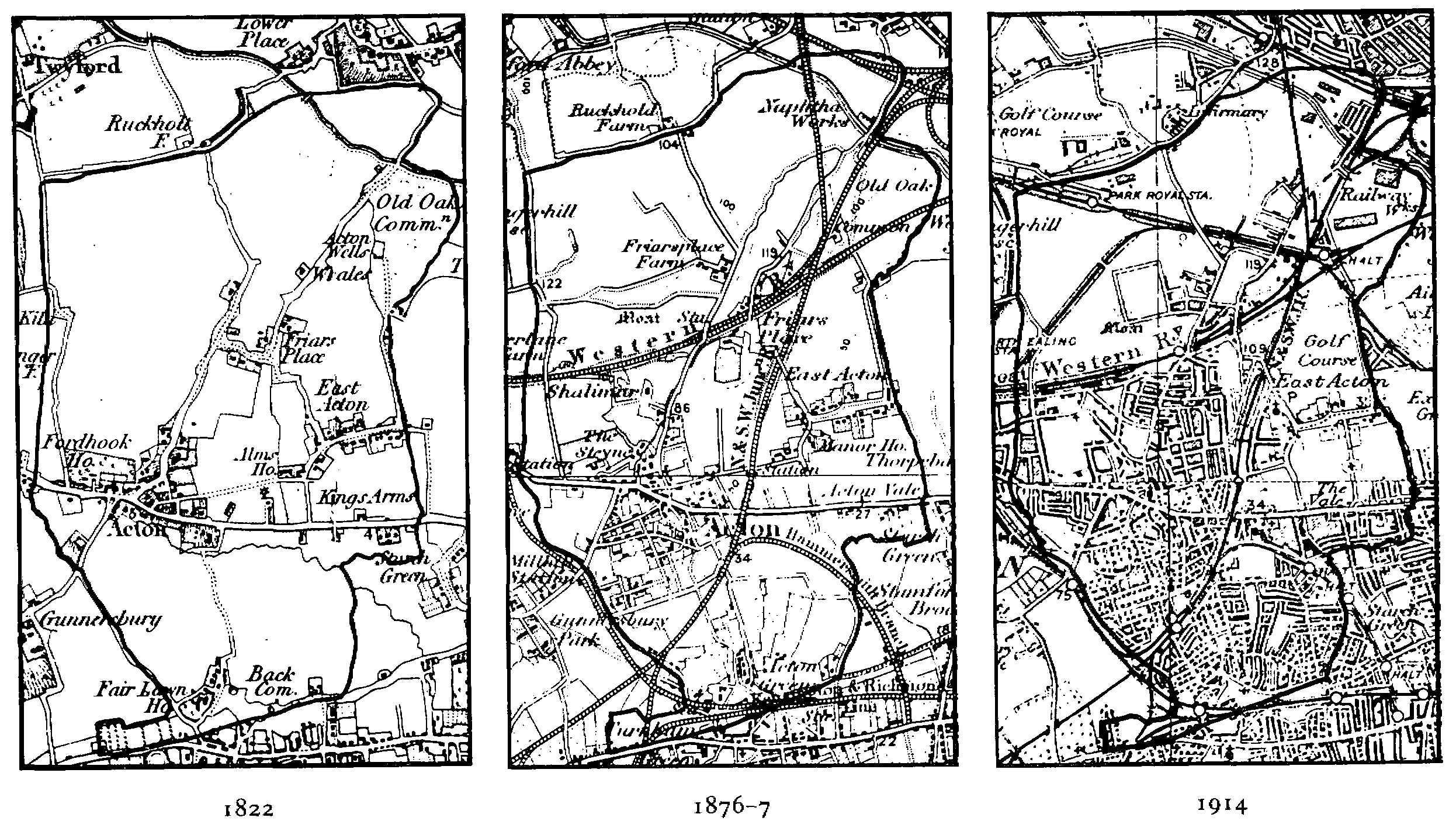
Acton: evolution of settlement, 1822-1914
(1 inch to 1 mile)
Building began in the 1860s. In Mill Hill and Church roads and Gunnersbury Lane, all near the town, and Shakespeare and Grove roads, near both town and railway, plots were sold quite quickly, mainly in small numbers. The new houses in general were two-storeyed terraces or semi-detached villas, with fairly low rentals, for those who worked locally. Such piecemeal sales may explain why much building was in the style of 30 years earlier. (fn. 86) Three-storeyed houses for the middle classes were built in Alfred Road by 1866 and Birkbeck Road c. 1870 near the N.L.R. line. Avenue Road and parts of Mill Hill Road also had several detached and semi-detached three-storeyed houses, as did Leamington Park and York Road, just north of the G. W. R. line, and Essex Road, to the south, where a few were built c. 1870 soon after the opening of the mainline station. Middle-class housing proved difficult to let, however, and supply constantly outstripped demand in the 19th century: in 1871 one in six of Acton's houses was unoccupied. Poor rail services may have been partly responsible, since links with the City, by the N.L.R. from 1865, were barely adequate and the west end of London was hard to reach. Building activity soon petered out and the Goldsmiths' Company's plan of 1868 for low-density housing on the 14-a. Churchfield estate produced very few houses.
Demand for cheaper housing continued steadily. While the larger plots on the Mill Hill estate farther from the town were slow to fill, plots in South Acton sold by the British Land Co. with some frontages only half the width of those north of Mill Hill House were soon covered with small houses, mostly for workers in laundries or such occupations as brickmaking. Building began in Enfield, Hanbury, Osborne, and Bollo Bridge roads in the mid 1860s, spreading southeastward to the N.L.R. line after 1867. Beyond the railway Rothschild and Antrobus roads and Cunnington Street were built up c. 1870, as were Berrymede and Priory roads east of Acton Lane, where the British Land Co. had bought land in 1868. Such building by land companies tended to be free from restrictions on use, with the result that South Acton quickly became a mixed industrial and residential district. Laundries were run in private houses, (fn. 87) several occupiers kept pigs, and businesses included bonecrushing plants and slaughterhouses. As early as 1869 the local board held an inquiry into conditions there, and officials constantly tried to remove pigs and noxious trades. (fn. 88) A characteristic mixture of use nonetheless survived in 1980, wherever the original houses still stood.
In the late 1870s building for the middle classes resumed north of the town. A few more large houses were built in Essex Road and along Horn Lane and in 1877 the 77–a. Springfield estate was divided into plots of 1/5 a. About half of the plots had detached houses with 5 or 6 bedrooms by 1885, mainly in Rosemont, Pierrepoint, and Creswick roads, with a few farther north in Lynton Road. East of Horn Lane the Birkbeck Land Society laid out Allison and Brougham roads and Birkbeck Avenue on 9 a. purchased c. 1868, where most of the c. 70 terraced and small semi-detached villas planned had been built by 1885, although several sites remained vacant.
South of the town Mill Hill House and its land, which had been offered for building in 1869 and 1873, were finally sold in 1877. A private estate was laid out, with gates at its Avenue Road entrances and its three roads, Heathfield Road, Avenue Crescent, and Avenue Gardens, forming a cul-de-sac that made a barrier between the middle-class area to the north and working-class South Acton. By 1885 several large houses had been built, mainly at the Avenue Road end. Meanwhile a distinctive suburb was being built up at Bedford Park close to Acton Green, partly in Acton and partly in Chiswick. (fn. 89)
The Goldsmiths' Company began further attempts to build in 1879, granting leases incorporating brickmaking agreements for c. 40 a., mainly to George Wright for low-density housing, but again with only mixed success. Work began on 1½ a. near the N.L.R. line on the north side of Churchfield Road East, with 12 houses, and spread to 14 a. to the north. By 1885 c. 50 houses, half the agreed number, had been built in Churchfield, Perryn, and Shaa roads. Another 25 were built between 1886 and 1892 but activity tailed off thereafter. A local builder, Frederick Bray, leased 9 a. in 1879 and had built 22 middle-class houses in Cumberland Park by 1882.
Although more workmen's trains were said to be needed in the 1880s to encourage residence in Acton, the demand for cheap housing persisted. Middle-class housing became still harder to let, not only because of poor train services but increasingly because the social status of Acton, with its many laundries, was declining. Between 1885 and 1895 no middle-class estates were started and very little building took place on the existing ones. Grafton Road and Baldwin Gardens were laid out in the late 1880s but few plots were sold and only a handful of detached three-storeyed villas was built. The Goldsmiths' Company finally abandoned its earliest Churchfield scheme, selling the site to the local board in 1888 for Acton park. (fn. 90) On its other sites only 25 out of 190 planned houses were built between 1888 and 1892 and those were difficult to let, even at two thirds of the rent for similar houses in Ealing or Hampstead.
An injunction for the Metropolitan Board of Works, against connecting sewers to its system, also hampered building (fn. 91) until the local board provided comprehensive drainage. Inadequate drainage caused the board to refuse permission for more building in Leamington Park and seems also to have hindered work on the Berrymead, Beaumont Park, and Cowper-Essex estates. On the Elms estate, west of the town, building did not start, although roads across it linking Springfield Park with houses in Ealing were laid out in 1879.
Building leases were granted on the 130-a. Cowper-Essex estate in the Vale between 1878 and 1882 but only a few houses along Uxbridge Road were ready by 1885. In South Acton, 32 a. on either side of the N.L.R. line were sold by the Royal Society and offered for building as the South Acton station estate, where the first plots were bought quickly in 1882 but 50 remained unsold in 1889. The area around Brouncker Road was mostly built up by 1890, with narrow frontages as elsewhere in South Acton, while in Petersfield Road two-storeyed terraces formed maisonette flats, with double entrance doors and bow fronts, which became typical of much working-class housing of the period. Part of the estate remained open, as South Acton playing fields. (fn. 92)
The adjacent Beaumont Park estate was sold in 1882, to the National Liberal Land Co., and built up in a similar way. There, too, the lack of restriction on use, apart from noxious trades, produced small businesses among the dwellings. Although some plots were soon sold, the estate had been only partly completed by 1894. West of Acton Green and adjacent to the District line station, Fairlawn Park was planned in 1880 but approval for building was given only in 1888. On the Berrymead Priory estate, sold in 1882 to the Reading Land Co., later Berkshire Estates Co., plots were not sold until 1889, and by 1894 only half of Berrymead Gardens and part of the west side of Winchester Street had been built up, with two-storeyed terraces. Most of the rest of Winchester and Salisbury streets was sold to the U.D.C. for municipal buildings. The house itself remained, while the area south of it fronting Acton Lane became the site of a large bakery.
The last two major sites in South Acton were sold for building in 1895. One lay next to Bollo Lane north-west of the N.L.R. line and formed the South Acton estate. At first plots were advertised for medium-sized houses but the demand for cheaper property, as in the rest of the district, prevailed and cottages and laundries were proposed by 1896. In Stirling and Colville roads 178 cottages were approved, and most apparently had been built by the early 1900s. The other site was north of Acton Green and west of Bedford Park, where roads were laid out in 1898 but building started only after 1900. Building in the Southfield Park estate, off Southfield Road, and in Carlton Road, to the north, also began in 1900. (fn. 93)
By 1908 the houses south of Uxbridge Road, excluding Bedford Park, were described either as six-roomed houses of c. 1880, very often subdivided, or more recent two-storeyed terraces. North of Uxbridge Road the demand for the large villas of the 1860s had declined and many of those, too, had been subdivided.
Acton's population rose unusually rapidly, by half between 1901 and 1911, largely because of the spread of industry. (fn. 94) House building therefore greatly increased between 1901 and 1905, although it slackened before the First World War, (fn. 95) while electrification of the trams caused property values near by to rise sharply. (fn. 96) Building on the c. 100-a. Elms estate, on the north side of the tram route, at last started in 1904, although part of the earlier road system was abandoned and extensive sports grounds belonging to the Gas Light & Coke Co., later North Thames Gas, cut off most of the estate from Springfield Park. Land east and west of Twyford Avenue was quickly covered with three-storeyed semidetached houses. Part of the Heathfield Lodge estate south of Uxbridge Road was also built up.
At the eastern end of Uxbridge Road, the Goldsmiths' Company still insisted on expensive housing whose attractions were diminished by industry on the south side of the Vale. The Town and General Estates Co. leased 111 a. bounded by East Acton Lane, Uxbridge Road, and Old Oak Road, and in 1903 advertised the Acton Park estate, where building was to begin on the eastern side. A grid of roads was laid out between Old Oak Road and Bromyard Avenue, and a road from the Vale to Crown Lane replaced the footpath across East field. Some building took place in Old Oak Road and in First, Second, and Third avenues c. 1905, but only about half of the plots had been filled by 1914. (fn. 97)
South of the Vale, in contrast, the land bounded by the main road and the Hammersmith branch line was rapidly being covered between 1900 and 1910 with large factory sites, (fn. 98) interspersed with a few short terraces of houses, giving Acton the industrial character that has since typified it.
Some building also took place in the northern part of the parish between 1900 and 1910. A few rows of cottages had been built in 1889 by the L.N.W.R. for its employees in Old Oak Lane near Willesden junction. Known as Railway Cottages and later as Stephenson and Goodhall streets, with a railway institute and a mission church and school added soon afterwards, they had little connexion with the rest of Acton. Victoria Road was laid down in 1901 and some terraces were soon built in and around Victoria Road and Midland Terrace. Chandos, School, Bethune, and St. Leonard's roads were laid out at that time and a large school was built there in 1909. Terraced houses were also built on a triangular site, formerly Wells House farm, c. 1906, but they remained cut off on the south and west by railway lines. (fn. 99)
The First World War accelerated the growth of industry, by benefiting local engineering firms. In the north part of Acton it also led to the building of munitions factories, which were sold after the war to private companies. By 1919 almost all the area south of Uxbridge Road had been built over and the northern part was rapidly following. The density of South-East and SouthWest wards was 63 and 82 people an acre respectively, compared with only 15 and 17 in the two northern wards. Although housing in SouthWest ward was described as poor, the streets were wide, there were no back-to-back houses or courts, and every dwelling had its own garden and yard. Cheaper houses never met the demand, and rarely remained unlet. South-West ward had 157 overcrowded dwellings, out of 243 in the whole parish, and 1,700 new houses were needed. (fn. 100)
The council became the main builder after the First World War, buying two sites for workingclass housing: 59 a. north of the Goldsmiths' land at East Acton between Old Oak Common Lane and the N.L.R. line, to which 15½ a. were later added, for 600 houses, and 18 a. west of Friars Place farm for 175 houses. At East Acton, also known briefly as Acton Wells estate, 268 houses were built under contract, and another 22 by direct labour. Thirty were built by the housing board of the Ministry of Health in order to demonstrate types of construction, including the 'Selfridge' concrete houses, and were opened in 1920. The cut in housing subsidies in 1921, however, forced the council to lease or sell the remaining land to private builders. (fn. 101)
The site near Friars Place farm, around North Acton playing fields which were opened in 1908, (fn. 102) was planned as a garden suburb in 1909, (fn. 103) but building apparently was not carried out until after the war, when the council sold or leased the land. The Victory Construction Co. built 70 bungalows for Gordon Selfridge in Lowfield and Westfield roads in 1919 and 1920, Acton residents receiving the first option to buy them. (fn. 104) The G.W.R. formed the Great Western (London) Garden Village Society in the 1920s, a co-operative which built an estate of 115 houses and shops between 1924 and 1931 on land just east of West Acton station. The houses were let to railwaymen, who held shares in the cooperative, (fn. 105) and were similar to council houses. West of the station, on land formerly part of Acton airfield, the private Hanger Hill Garden Estate was laid out between 1925 and 1933, with 325 houses on five-year leases and set in landscaped gardens which contained a sports ground and club house managed by the tenants. (fn. 106) Most of the spaces on estates which had been started in the 1870s were filled in the period between the World Wars, with private housing for the middle classes. (fn. 107) After Western Avenue had been built, there was no new housing to the north except on the Friars estate and in Harold Road and Wesley Avenue, laid out for its employees by Harold Wesley Ltd. The area was almost entirely built up with factories by the mid 1930s, together with a part of Acton aerodrome south of Western Avenue. (fn. 108)
South of Western Avenue the Goldsmiths' Company built on the land between the road and East Acton village after 1928, with Bowes, Gibbon, and Foster roads, and the earlier gaps were filled in. (fn. 109) South of the village the company let a site in Bromyard Avenue for the huge Ministry of Pensions office in 1920 and built Perryn House with 36 flats to the north, but the rest of its land around Manor House was used mainly for sports grounds and allotments. (fn. 110) By 1932 the whole of East Acton south of Western Avenue, except the sports grounds, had been built up.
The council resumed building in 1930, with 4 blocks of 4 flats each in Perryn Road and 3 at the corner of Brassie Road and Old Oak Common Lane (fn. 111) and another 8 flats each in Enfield and Brouncker roads, South Acton, in 1931 and 1932. It also built 64 flats in blocks of 4 and a few semidetached houses on the Friars estate in Conway Grove and Acorn Gardens, off Wales Farm Road, in 1932, and 52 flats and 2 houses in Canada Crescent near Friars Place farm in 1934. (fn. 112) After a survey in 1935 had found that 2.5 per cent of working-class dwellings were overcrowded, (fn. 113) the council built flats in the Steyne and the Vale: Steyne House was finished by 1939 and 32 flats were occupied by tenants transferred from the East Acton estate. (fn. 114)
After the Second World War the council began to build on 9½ a. on the north side of the Vale. (fn. 115) There were 318 flats by 1948, in 6 four-storeyed blocks along Beech Avenue, with a recreation ground on the north side. (fn. 116) By the end of 1951 the council had built 606 dwellings, mainly flats, since the war; another 132 were under construction and 51 were planned, while 274 bombed dwellings had been rebuilt, mostly under private licence. (fn. 117) By the end of 1961 post-war dwellings numbered 1,793. (fn. 118) Municipal building was mainly in South Acton, between Bollo Lane, Avenue Road, Strafford Road, and the N.L.R. line, where nearly all the older buildings except the Mill Hill Park estate were demolished. The area south of Bollo Bridge Road became the South Acton industrial estate. North of Bollo Bridge Road the houses were replaced by flats and maisonettes, with a few shops in Hanbury Road. Two tower blocks of 22 storeys and three of 13 dominated the open ground, (fn. 119) with several blocks of 6 storeys or less near by and some smaller blocks of maisonettes to the west. As elsewhere, however, the tower blocks were thought to breed crime, to the extent that an inquiry was held by the local M.P., Sir George Young, in 1977. (fn. 120) Later large building schemes, south of High Street and at Acton Green between Beaconsfield Road and Acton Lane, avoided the stark appearance of tower blocks and consisted of red-brick flats and maisonettes on varying levels.
The population of the parish was 1,425 in 1801, 1,929 in 1821, and 2,665 in 1841. It was only 2,582 in 1851 but rose to 3,151 in 1861 and 8,306 by 1871. Thereafter it increased rapidly to 17,126 in 1881, 24,206 in 1891, 37,744 in 1901, and 57,497 in 1911. Numbers reached 61,299 in 1921 and 70,510 in 1931, before falling to 64,471 in 1951 and 65,586 in 1961. (fn. 121)