A History of the County of Middlesex: Volume 9, Hampstead, Paddington. Originally published by Victoria County History, London, 1989.
This free content was digitised by double rekeying. All rights reserved.
T F T Baker, Diane K Bolton, Patricia E C Croot, 'Hampstead: Belsize', in A History of the County of Middlesex: Volume 9, Hampstead, Paddington, ed. C R Elrington (London, 1989), British History Online https://www.british-history.ac.uk/vch/middx/vol9/pp51-60 [accessed 1 May 2025].
T F T Baker, Diane K Bolton, Patricia E C Croot, 'Hampstead: Belsize', in A History of the County of Middlesex: Volume 9, Hampstead, Paddington. Edited by C R Elrington (London, 1989), British History Online, accessed May 1, 2025, https://www.british-history.ac.uk/vch/middx/vol9/pp51-60.
T F T Baker, Diane K Bolton, Patricia E C Croot. "Hampstead: Belsize". A History of the County of Middlesex: Volume 9, Hampstead, Paddington. Ed. C R Elrington (London, 1989), British History Online. Web. 1 May 2025. https://www.british-history.ac.uk/vch/middx/vol9/pp51-60.
Belsize. (fn. 1)
The Belsize estate, with its frontage on both sides of Haverstock Hill, was an early magnet for merchants and others who wanted a country house within easy reach of London. Apart from the manor house of Belsize, there was one house on the estate by 1549, probably on the eastern side of Haverstock Hill, near the southern boundary of the parish. (fn. 2) It was associated with brickmaking by 1557, by which date there were two other houses, one of them a new house belonging to Philip Cockram (or Cokerham), a London mercer. (fn. 3) Cockram's house apparently existed in 1664, when it was assessed for 5 hearths. (fn. 4) On the west side of the main road a house was built by Sir Isaac Wake (d. 1632), a courtier. Screened by a grove, and standing back from the road, it was described as a fine seat with its views and walks of pines and firs. (fn. 5) The house, which was assessed at 17 hearths, one of the largest in the parish, in 1664, (fn. 6) had passed by 1646 to John Wilde, Chief Baron of the Exchequer and parliamentarian, who died there in 1669. (fn. 7) It was inherited by his daughter and her husband Charles West, Baron De La Warr (d. 1687), (fn. 8) who sold it c. 1683 to a London citizen, probably John Coggs, a goldsmith to whom the lease was assigned after 1685 and who rebuilt the house in 1686. The lease was assigned to Thomas Ketteridge, upholsterer, (fn. 9) and the underlease sold in 1711 to William Paget, Baron Paget (d. 1713), listed as occupier in 1714, when the house was set in formal gardens. (fn. 10)
Several other houses existed on the estate on the western side of Haverstock Hill by 1646. One, occupied by John Mascall, (fn. 11) who was still there in 1650, (fn. 12) was probably the house south of the Avenue which was occupied in 1679 by Thomas Butler (fn. 13) and in 1714 was called the Blue House. (fn. 14) Another, leased with 16 a. to Benjamin Rutland, was probably the farmhouse at the south end of the estate at the junction of the London road with what was later called England's Lane (fn. 15) in 1679; it was occupied by John Newman and in 1714 by Thomas Stringfield. (fn. 16) At the northern end of the estate Ambrose Turner occupied in 1646 a 'fair mansion house' (fn. 17) which was assessed in 1664 at 7 hearths (fn. 18) and between 1679 (fn. 19) and 1714 replaced by four houses, a shop and stable and a timber roughcast house in the extreme north, (fn. 20) which by 1730 housed the Red Lion. (fn. 21) In 1650 a dwelling had been formed from outbuildings belonging to the manor house (fn. 22) but it was presumably swept away in the rebuilding of the 1660s.
A large house, assessed at 16 hearths, was built between 1650 and 1664 on the north side of Belsize Lane. (fn. 23) Thomas Hawley or Haley (d. 1681), the London mercer who lived there, left it to his nephew to sell. (fn. 24) In 1714 it was called the White House and untenanted. Hawley may have built one or more houses nearby, which in 1714 were leased to Mrs. Hall. (fn. 25) Two more houses had been built by 1679. One, approached by a tree-lined walk from Wilde's house, lay on the western border of the estate and was then occupied by Mrs. Lister. (fn. 26) Although Elizabethan coins found under the floor and ringdating of a Spanish chestnut in the avenue, blown down in 1884, suggested that the house was late 16th-century, it is not identifiable with any of those described in 1650 and is more likely to have been built c. 1667, the date of leaden cisterns on the site. (fn. 27) In 1685 it was leased to Richard Mulys of St. James, Westminster, who replaced the old house, which included a pigeon house, with a brick and slated mansion erected by a Westminster carpenter and a Hampstead bricklayer, whose work he found unsatisfactory. (fn. 28) It was probably that house which was later described as four-square, with a high mansard roof and square corner-turrets with pyramidal roofs. The chimney piece was carved by a pupil of Grinling Gibbons. (fn. 29) The house, called Mulys, (fn. 30) was occupied in 1714 by Mrs. Mulys (fn. 31) and in 1723 by William Fellows, underlessee of Thomas Ketteridge, who was obliged by the terms of his lease to pay for new buildings and repairs. (fn. 32) John Harris, a goldsmith, was the tenant of the second new house to have been built by 1679, south of the junction of Belsize Lane and the London road. (fn. 33) Capt. Edward Harris spent a considerable sum in new buildings and repairs and had two houses by 1714. (fn. 34)
All the buildings on the eastern side of the London road, with the possible exception of a barn, had apparently gone from the Belsize estate by 1679. (fn. 35) An inn, called the Load of Hay or the Cart and Horses, stood on the roadside waste at the southern boundary by 1712. (fn. 36)
Between 1679 and 1714 the number of houses, excluding the manor house, increased from 6 or possibly 8 to 14; (fn. 37) by 1808 there were 22. (fn. 38) Apparently the whole estate suffered from the notoriety of Belsize House in the 1720s and 1730s (fn. 39) but in the later 18th century it again attracted outsiders of rank. Only three new houses were built between 1714 and 1750. One stood before 1723 on an orchard on Harris's estate on the south side of Belsize Lane at the point where the lane turned south-west. (fn. 40) In 1808 it was a 'Chinese-built cottage residence' (later Belsize Cottage). (fn. 41) The inhabitants of Hampstead subscribed c. 1734 to build a house for a poor cobbler, (fn. 42) which can probably be identified with a house and workshop on the waste on the east side of Haverstock Hill in 1762. (fn. 43) A 'neat timber and tiled' farmhouse, later called Holyland, Pickett's, or South End Farm, was built at South End Green probably by the 1740s. (fn. 44) Of the older houses, Wilde's was occupied by a Mr. Cartwright of St. James's in 1723 when over 100 trees in front were cut down by order of the bailiff of Hampstead manor. (fn. 45) It was let to a doctor in 1726 but had reverted to the lessee, Ketteridge, by the 1740s. It may have already fallen into decay and was almost certainly smaller than in the mid 17th century. (fn. 46) Mulys, later called Grove House, Shelford Lodge, and Rosslyn House, was occupied by the Fellows family from c. 1723 to c. 1777. (fn. 47)
A second house had probably been built on Wilde's estate by 1757. (fn. 48) One existed on the site later occupied by Rosslyn Lodge by 1774 (fn. 49) and another small one adjoining Wilde's by 1779. (fn. 50) Wilde's house was occupied by Sarah Ketteridge until 1770 when, as 'an old messuage', it was leased to John Stokes, probably a lawyer, who built a new house, coach house, and stables on the site. (fn. 51) In 1800 Stokes subleased to Thomas Roberts, (fn. 52) who in 1808 occupied a brick mansion (Rosslyn Grove), essentially the late 18th-century building standing in 1986, with stabling and pleasure grounds, 2½ a. in all. (fn. 53) Rosslyn Lodge was rebuilt, probably between 1799 and 1802, (fn. 54) and was described in 1808 as new, with four bedrooms, a double coach house, and gardener's house. (fn. 55) The small brick house next to Rosslyn Grove was in 1808 still occupied by a member of the Marchant family. (fn. 56)
The Blue House was rebuilt with stabling between 1761 and 1773 by the undertenant William Horseley, a merchant. (fn. 57) In 1808 it was occupied, with other buildings, a plantation, and pleasure grounds, by Thomas Pryor (d. 1821), who had been given it by his father-in-law Samuel Hoare (d. 1825) on his marriage in 1802; the Pryors later moved to Hampstead town. (fn. 58) The White House on the north side of Belsize Lane was in 1747 occupied by Sir Thomas Burnet (d. 1753), a judge of the Common Pleas. (fn. 59) In 1808, when occupied by George Todd, it had outbuildings, pleasure grounds, plantations, fishponds, and 7 a. (fn. 60) Nearby were two modest brick houses, (fn. 61) probably late 17th-century and rebuilt before 1735, (fn. 62) one of which was in bad repair. In 1747 one had been occupied by a surgeon and the other by George Errington, a copyholder in Hampstead town, who subleased to Andrew Regnier, a tailor from St. Martin-in-the-Fields, another copyholder, who in 1753 assigned the lease to a coffin-plate chaser from St. Sepulchre's. (fn. 63) On the south side of Belsize Lane, James Inglish, a Hampstead gentleman, in 1773 subleased Harris's house (later Elm House) to a merchant of Bucklersbury, (fn. 64) who probably rebuilt it. (fn. 65) In 1808 it was occupied by Benjamin Hanson Inglish and was a mansion with a bow window and had two coach houses. Adjoining it to the north was the brick house later called Belsize Lodge. (fn. 66)
At the southern end of the Belsize estate the farmland became detached during the 18th century from the farmhouse and barn at the junction with England's Lane. (fn. 67) By 1808 only the barn belonged to the farmer. The farmhouse had become two houses, part brick and part lath and plaster. Probably after 1773 a house, occupied in 1808 by a doctor, was built at the western end of England's Lane. (fn. 68) On the east side of Haverstock Hill a 'neat brick dwelling' was built c. 1770 next to the cobbler's house, which by 1808 was a decayed timber building, divided into three. (fn. 69) At the northern end of the estate the timber Red Lion survived until 1868 (fn. 70) but the other houses, of brick and timber, were replaced between 1752 and 1808 by four brick residences, each with a coach house and two of them tenanted in 1808 by Dobson Willoughby and Sir Richard Phillips. (fn. 71) Mulys or Shelford Lodge was occupied in 1789 by the Revd. Mr. Addison (fn. 72) and in 1792 was leased to Alexander Wedderburn, Lord Loughborough, Lord Chancellor and later earl of Rosslyn. He added a large oval room which held the library and disguised the shape of the original house, renamed Rosslyn House. Rosslyn left in 1803 (fn. 73) and in 1808 the house, a newly planted orchard, and 21 a., were occupied by Robert Milligan (d. 1809), a West India merchant. There were also houses for a gardener and a coachman. (fn. 74)
In 1808 the Belsize estate was split into nine leasehold estates, largely based upon the traditional underleases and focussed on single houses. (fn. 75) Until the 1850s Belsize was an area of country houses set in parkland. By 1815 George Todd, a former undertenant and one of the purchasers of 1808, had at great expense replaced the White House and the two neighbouring houses with a 'very capital mansion' called Belsize House, containing a library and conservatory, and with two coach houses and fine grounds. (fn. 76) Described in 1841 as a stuccoed Grecian villa with a stone portico and two lodges, (fn. 77) it was later called Belsize Court and occupied from 1833 by Matthew Forster (d. 1869), a London merchant and M.P. (fn. 78) It remained a seat until 1880 and was not demolished until 1937. (fn. 79) On the opposite side of Belsize Lane, but on the same estate, Belsize Cottage or Hunter's Lodge was built shortly before 1820 for William Tate, a merchant and undertenant, on the site of the 'Chinese' cottage of 1808. (fn. 80) Described in 1841, when it was occupied by another merchant James Lang, as a Gothic cottage villa, (fn. 81) it survived in 1986. At the eastern end of Todd's estate, Elm House and Belsize Lodge were replaced c. 1875 by Ivy Bank, which survived until 1911. (fn. 82)
John Lund, who bought Forsyth's estate on the eastern side of Haverstock Hill, built Haverstock Lodge for himself in 1819; (fn. 83) it survived until the First World War. (fn. 84) There was little building on the three estates leased to Thomas Roberts. South End Farm continued as a farmhouse and Rosslyn House was sold in 1816 to the undertenant and remained in parkland until it was demolished between 1896 and 1909. Occupiers included Sir Francis Freeling, secretary to the General Post Office c. 1814, (fn. 85) Lt.-Gen. Sir Moore Disney 1816-23, the dowager countess of Galloway 1835-41, the Soldiers' Daughters' Home 1855-8, and Charles H. L. Woodd from 1861 to his death in 1893. It was probably Woodd who removed a colonnade on the west side of the house and transferred the portico and main entrance from the east to the north side. (fn. 86) Rosslyn Grove remained the house of Roberts and his family until 1835 or later, and Rosslyn Lodge was leased from 1832 to 1874 to Arthur Johnstone Blackwood but occupied in 1851 by Count Edward Zohrab, a Turkish diplomat. (fn. 87) One new house was built on the Rosslyn Grove estate between 1808 and 1817, on the north corner of Belsize Lane and the London road. (fn. 88)
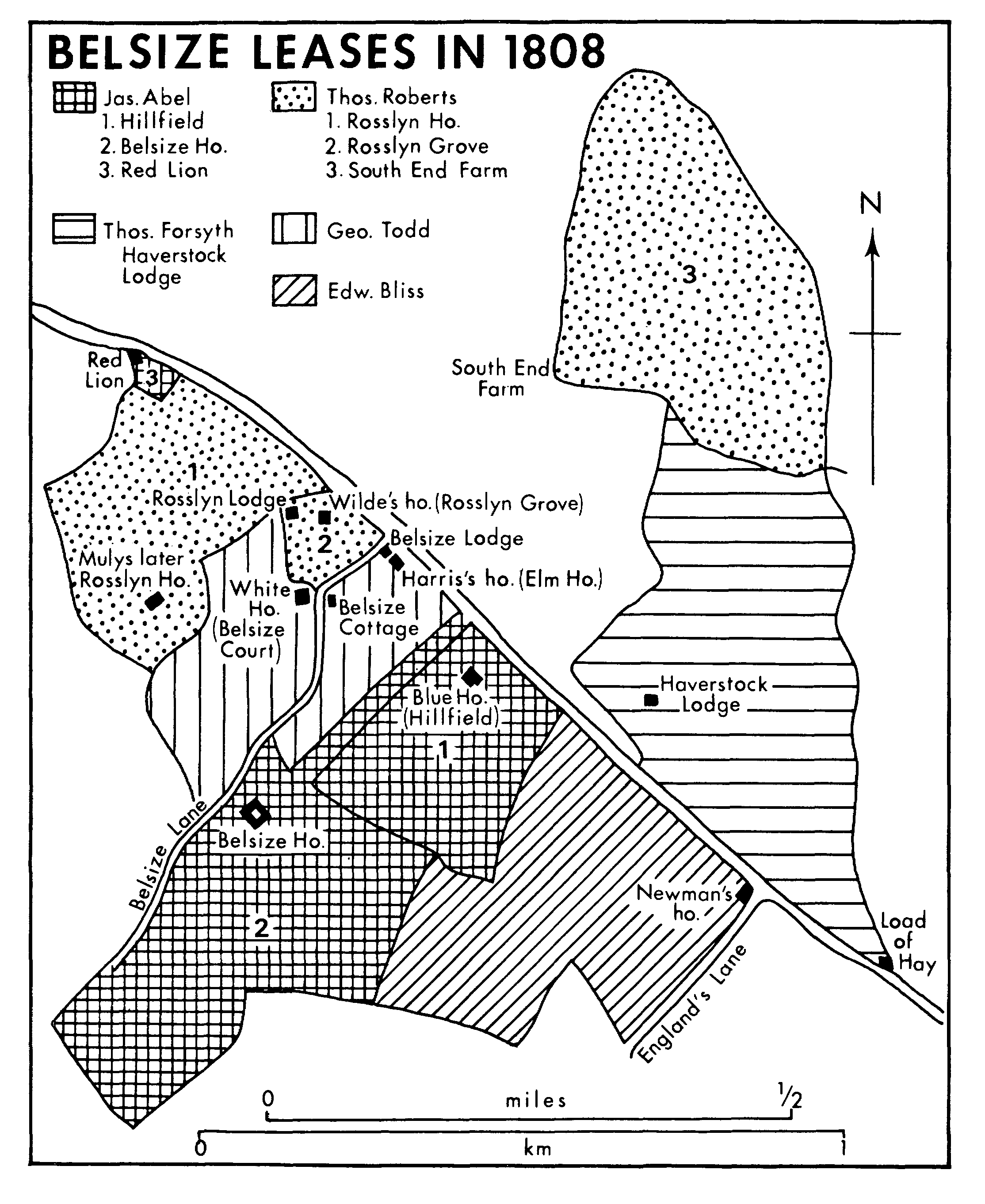
BELSIZE LEASES IN 1808
On James Abel's largest estate (Belsize Park), centred on Belsize House itself, there were by 1841, in addition to the main house, a large Gothic lodge with four coach houses, and a bailiff's house in Belsize Lane. (fn. 89) Blue House, on his Hillfield estate, was rebuilt or enlarged, probably by his undertenant, the wine merchant Basil George Woodd, before 1841, when it was called Heathfield House and had a 'modern' elevation, a stuccoed front, a library, and six bedrooms. (fn. 90) Since the value quadrupled between 1841 and 1857 Woodd probably improved the house which he then called Hillfield; it survived until 1928. (fn. 91) Between 1864 and 1868 he built a second large house, Woodlands, at the southern end of what had become his freehold estate, for his son Robert Ballard Woodd. (fn. 92)
The only estate to be exploited early as a building venture was that of Edward Bliss on the west side of Haverstock Hill, north of England's Lane. Bliss, a self-made man, began developing the 14 a. fronting Haverstock Hill soon after 1815. In addition to the single and paired villas like Devonshire House, probably built by Basil Woodd in 1826, there were terraces like the Grecian-style Haverstock Terrace (in 1986 nos. 26-38 Belsize Grove), built in 1825-6, and Devonshire Place. Almost all the 38 houses on the estate had been built by 1830, with stabling and occupied by 'persons of quality'. Bliss made the land available, on underleases to his lease for lives, both to individuals and to speculators like George Crane of Cheltenham, who built Bedford, Oak, and Gilling lodges in addition to Haverstock Terrace. (fn. 93)
In 1842 an Act enabled Church lands to be let on long building leases and in 1851 the opening of Hampstead Road station prompted William Lund, lessee of the Forsyth estate, to secure a 99-year building lease in 1852. (fn. 94) Setting aside c. 8 a. around his home, Haverstock Lodge, Lund planned an estate called St. John's Park on the other 38 a. His initial scheme, for parallel curving roads from Haverstock Hill to his boundary at the Fleet, linked by four cross roads, was soon modified, with Lawn Road replacing a lake intended for his own grounds. There were to be c. 280 buildings, consisting of 133 semi-detached villas on c. 29 a. and terraces, shops, and mews on the low-lying land by the river. (fn. 95) Building began from the Haverstock Hill end and by 1862 Park (later Parkhill) Road and Fleet Road, as yet unnamed, were laid out, together with the southwestern half of Lawn Road and Upper Park Road. About 60 houses had been built on those roads and fronting Haverstock Hill, where the houses were called St. John's Park Villas. Most were substantial and 'unobtrusively classical', of grey brick and stucco, many built by Richard Batterbury of Camden Town, the chief speculative builder. (fn. 96) Church (after 1937 Tasker) Road and Lower Cross (after 1934 Garnett) Road had been laid out by 1862 but no houses built. (fn. 97) Residents were described in a guidebook of the 1860s on Haverstock Hill as 'City men such as stockbrokers, merchants, and commercial agents'. (fn. 98)
In 1852 Charles James Palmer, a Bloomsbury solicitor, bought the lease of the Belsize House estate (Belsize Park), one of Abel's leases and the largest of the country house estates, with the intention of building. (fn. 99) The land lay between the two London roads, Haverstock Hill and the new Finchley Road, (fn. 100) and the decision of the chapter of Westminster to retain control of the Avenue prompted Palmer to orientate the layout towards Finchley Road, with access through College Crescent, where houses had been built in 1849. (fn. 101) In 1853 Palmer proposed to demolish the manor house and build, under a 99-year building lease, a church in a square with detached and semi-detached houses and stables to the north, forming a secluded estate of five, mostly large, houses to the acre. (fn. 102) The formal building lease was not drawn up until 1855, (fn. 103) by which time Palmer, who had been paying high rent, was ready to allow modifications of the plan by the principal builder Daniel Tidey, a Sussex-born man who lived in one of his own houses in Belsize Park. In haste to secure the wealthiest clients, Tidey started work in 1855 from the western end, fronting the existing Belsize Lane, followed by Belsize Park and Buckland Crescent, in all of which he built large stuccoed town houses, where Palmer had planned the service quarter. (fn. 104) In 1863 Belsize Park had 'labyrinths of streets that will ultimately bear comparison with Belgravia'. (fn. 105) The eight- or tenbedroomed houses were built for the wealthy professional and commercial class rather than for aristocratic occupation. In 1858 only 50 houses had been built; very few were occupied and those only by persons 'of very limited incomes'. (fn. 106) By 1864 there were more than 100 families on the estate although few kept carriages, there being only one block of 12 stables at Belsize Lane. By the 1870s, however, there were some 120 stables, an average of one to four houses, more than in other parts of Hampstead. (fn. 107)
In 1853 Henry Davidson agreed to exchange his lease for lives of the Rosslyn House estate for a 99-year building lease, which was drawn up in 1855. Probably fearing that the market would be saturated by building on the neighbouring Maryon Wilson land, Davidson hoped to demolish Rosslyn House and cover the whole estate with detached and semidetached houses, like those in Belsize Park and with access from Haverstock Hill. (fn. 108) Progress was slower than expected, partly because of competition in Hampstead town and Belsize Park and partly because of reluctance to build above Hampstead Junction Railway's tunnel. In 1859 Davidson sold Rosslyn House and the south-western part of the estate to Charles Henry Lardner Woodd, who kept it as a country house until his death in 1893. On the rest of the estate Thurlow, Lyndhurst, and Eldon roads and Windsor Terrace had been laid out by 1862 and c. 40 houses built by 1864, mostly fronting Haverstock Hill. (fn. 109) Demand for the houses, of similar value to those in Belsize Park, (fn. 110) rose during the 1860s and more had been built by 1870. (fn. 111)
In 1864 the chapter of Westminster bought out the lessee's interest in the 24 a. of undeveloped backland on the Bliss estate and transferred it to Daniel Tidey on a 99-year building agreement. (fn. 112) Tidey destroyed the exclusivity of Belsize Park by extending its roads southward into Bliss's estate and by 1866 had drawn up a plan for the two estates, linked to Chalcots estate. (fn. 113) He began building in England's Lane in 1865 and by 1870 had pushed St. Margaret's Road (later Belsize Park Gardens) into Bliss's estate. (fn. 114) He was building in Stanley (after 1939 Primrose) Gardens in 1871. (fn. 115)
In 1857 the chapter had acquired full control over the portion of Todd's lease north of Belsize Lane and in 1865 it made an agreement with Tidey for the western 4½ a. (fn. 116) He constructed Prince Consort Road (later Belsize Crescent) as a northern extension of the Belsize Park estate and in 1869 subleased it to William Willett, another important builder in Hampstead. Tidey had constructed over 250 houses on the three Belsize estates by 1870, when he went bankrupt. (fn. 117)
By 1870 all the Belsize estates were socially homogeneous, with mainly detached and semi-detached houses in a classical or Italianate style, broken only by small groups of mews. (fn. 118) There were many barristers, merchants, stockbrokers, fundholders, and clerks, ranging from senior civil servants to more lowly commercial clerks on Lund's estate. In 1861 residents included an author in Haverstock Place, a sculptor in Devonshire Place, and two architects in College Terrace. (fn. 119) The artist William Dobson (1817-98) lived in Eldon House in Eldon Grove from c. 1861 to 1883, the publisher Charles Knight (1791-1873) at no. 7 Eldon Grove from 1864-1870, and the artist Clarkson Stanfield (1793-1867) at no. 6 Belsize Park from 1865 to 1867; the dramatist G. W. Lovell (1804-78) died at no. 18 Lyndhurst Road. (fn. 120)
In 1869 Richard Pierce Barker exchanged his lease for lives of the portion of Todd's estate south of Belsize Lane for a building lease and planned a new road, Ornan Road. (fn. 121) The northern 5 a. were occupied by Belsize Cottage and Elm House, subleased until 1884, but the other 7½ a., Ornan Road and the northern side of Belsize Avenue, was to be developed for high-class detached and semi-detached houses. Building, mostly by William Willett, proceeded on both sides of Belsize Avenue from 1871 and in Ornan Road from 1878. (fn. 122)
Activity continued throughout the 1870s under the several building leases. Belsize Park was virtually built up by 1878, with the development of Lancaster Road (later Grove), as was the whole of Tidey's 4½-a. extension north of Belsize Lane. On Bliss's estate only the western section remained, where Lancaster Road, Lamboll Road, and Lamboll Place had been constructed but ew houses built. Building was nearly complete on the northern part of the Rosslyn House estate, where it continued into the 1880s, 42 houses, for example, being built in Stanley Gardens between 1879 and 1882. (fn. 123)
The chief builder after Tidey's bankruptcy was William Willett (1837-1913), helped, probably from 1881, by his son William (1856-1915), the originator of 'daylight saving'. (fn. 124) A fashionable builder in Kensington from 1876, the elder Willett opened an office in Belsize Court after 1873 and, having built some cramped houses in Belsize Crescent, put up large houses in Belsize Avenue. (fn. 125) In 1880 he obtained a 99-year lease of 12 a. of the Belsize Court estate, (fn. 126) where from 1886 he built Lyndhurst Gardens and Wedderburn Road. (fn. 127) The Willetts' houses were solidly constructed and set a new artistic standard for speculative architecture. In contrast with the classicism of Tidey's, they were red-brick and varied in design, many of them by the Willetts' own architects Harry B. Measures and, after 1891, Amos Faulkner. (fn. 128)
In 1881 the Rosslyn Grove estate, whose freehold had reverted to the Church Commissioners, was leased to Congregationalists who in 1883 built a church on the corner of Lyndhurst Road and Haverstock Hill, retained Rosslyn Grove as a manse, and sold the southern part of the estate; Rosslyn Gardens (later nos. 4-26 Belsize Lane) was built there about the same time. (fn. 129) On his Hillfield estate, by then freehold, Basil Thomas Woodd gave a site for the vestry hall in 1878 and built houses fronting Belsize Avenue in 1883. (fn. 130)
In the 1880s and early 1890s the entire Belsize estate west of Haverstock Hill was occupied by people classified as living 'in comfort'. Mews, in Lancaster Road, north of England's Lane, and especially in the centre of Belsize Lane, were occupied by the 'fairly comfortable', such as coachmen, gardeners, tradesmen, and craftsmen, but most of Belsize Park was 'upper middle- and middle-class, wealthy' and the other estates to north and south were 'middle-class, well-to-do'. (fn. 131) Inhabitants included Cornelius Walford (1827-85), the writer on insurance and owner of 30,000 rare books in two adjoining houses at Belsize Park Gardens, the composer Martin Shaw (1875-1958) at no. 18 Belsize Lane probably in the 1890s, the writer Lytton Strachey (1880-1932) at no. 67 Belsize Park Gardens from 1907 and at no. 6 from 1914, and, in his youth, the newspaper proprietor Harold Harmsworth, later Viscount Rothermere (1868-1940), in Wedderburn Road. (fn. 132)
It was the area on the eastern side of Haverstock Hill, Lund's St. John's Park, however, that was noted in the 1880s and 1890s for good houses occupied by artists and professional people, (fn. 133) probably mainly because of the Mall studios, built by Thomas Batterbury behind Park Road in 1872. (fn. 134) Artists who used them included Robert Macbeth (1848-1910), from 1875 to 1879, who lived in Park Road in 1873, and Sir George Clausen (1852-1944) c. 1879. Thomas Danby (1817?-86), the landscape painter, lived at no. 44 Upper Park Road from 1869 to 1882 and Arthur Rackham (1867-1939), the illustrator, at no. 54A Parkhill Road in 1903. The author Henry Morley (1822-94) lived at no. 8 Upper Park Road from 1858, and Thomas Wise, the forger, lived at no. 23 Downshire Crescent from 1901 to 1911. (fn. 135) The district, from Haverstock Hill north to just beyond Church (Tasker) Road, was 'well-to-do, middleclass'. (fn. 136) The area to the north, however, consisted of modern roads occupied by 'decent artisans', large tram stables at South End, and streets near Fleet Road housing transport workers and labourers. (fn. 137)
Lund's plans for the northern part of the Haverstock Lodge estate were distorted from the start, partly because the river Fleet's unsavoury condition prevented the establishment of a middle-class shopping quarter, partly because of refusals to build above the St. Pancras tunnel extension of the Midland railway, completed in 1866 just south of Lower Cross Road. The final blight was the opening in 1870 of the smallpox hospital on the Bartrams site. (fn. 138) Building virtually stopped until c. 30 houses and 12 stables were built between 1879 and 1885 in Park, Upper Park, and Lawn roads. By that date the social status of the estate had started to decline and workshops were built at the Grange, Park Road, in 1883-4. Terraces, a mission house, and a working men's club were built in the late 1870s and 1880s in Fleet Road and in 1893 a resident of Upper Park Road recorded the tenementation of houses at the north end of the street to 'objectionable people'. (fn. 139)
In 1872 the dean and chapter of Westminster became aware of building next to their South End farm and agreed with Joseph Salter, the owner of Hodges, to straighten the boundary and enable him to make a road (Cressy Road) and sewer preparatory to development. (fn. 140) The scheme was delayed by the effects of the smallpox hospital, and some partly built houses were taken down. (fn. 141) In 1878 the chapter made a building agreement with Joseph Pickett, the tenant of South End farm, and John Ashwell, a Kentish Town builder, for the 15½ a. north of the Hampstead Junction Railway. (fn. 142) The area, farther from the smallpox hospital and on higher ground next to the heath, proved more attractive and South Hill Park Road (later Parliament Hill Road) and Nassington Road were laid out in 1878 and 90 houses built between 1879 and 1892. The planned extension of the roads into Lord Mansfield's lands in St. Pancras was halted by the addition of Parliament Hill Fields to the heath in 1889. Tanza Road was made instead, to connect the existing roads, and building began there in 1890. (fn. 143) Ashwell withdrew in 1881 and Pickett (d. 1893), who by then described himself as a master builder and lived in South Hill Park, was under-financed and built cheaply, mostly semi-detached and terraced tall but cramped redbrick houses for the middle class. In 1881 the eight existing houses in South Hill Park Road contained a commercial traveller, a teacher, an annuitant, a clerk, and a lodging house. (fn. 144) Richard Garnett (1835- 1906), writer and president of the Hampstead Antiquarian and Historical Society, lived at no. 27 Tanza Road from 1899. (fn. 145)
In 1880 Thomas E. Gibb, a developer from Kentish Town and trustee of Salter's estate, purchased some 3½ a. of South End farm, adjoining Salter's land on the south-west. In 1881 he took a 99-year lease on the remaining 11 a. of farmland, the rest having been sold to the railway and the London school board, and undertook to build 120 small houses at 'the lower end of middle-class respectability'. He planned to cover both Salter's freehold estate and the southern part of South End farm and agreed to construct a sewer which would also serve Pickett's northern portion of the estate. (fn. 146) Gibb laid out Cressy (sic), Agincourt, and Lisburne roads and began brickmaking on the Salter estate, but the smallpox hospital unexpectedly reopened and, indeed, expanded. Patients were brought along Fleet Road and the area deteriorated even further. No one would take houses and for years the only buildings in the new roads were two houses, a school chapel, the board school, factories, and a steam laundry. In 1886 the Church Commissioners, recognizing the social change, allowed Gibb to build 215 houses on the 11 a.; Constantine Road was planned, as a direct route from Gospel Oak and Kentish Town to South End Green and the heath, and building began in 1887. By 1894, when Gibb died, 113 houses had been built in Constantine, Agincourt, and Lisburne roads. Gibb's interest passed to Francis Thomas Binnington, a Hampstead surveyor, who subleased to Robert Thorpe and John Sanders, local men who had built for Gibb and Pickett. By 1898 another 153 houses had gone up, in Constantine, Cressy, and Mackeson roads. (fn. 147)
Most of the remaining large houses marooned in their gardens disappeared in the 1890s. The Ivy Bank (Elm House) estate south of Belsize Lane was for sale in 1893 (fn. 148) and building was taking place in the grounds from 1894, including Ornan and Rosslyn Court, large flats in Ornan Road (1896). The house, which was occupied from 1897 to 1911 by Alfred Ridley Bax, F.S.A., and his sons, the composer Sir Arnold (1883-1953) and author and playwright Clifford, was replaced in 1911 by Beaulieu (later Perceval) Avenue. (fn. 149) The last houses were built there in 1924 and six semi-detached ones were built on the site fronting Haverstock Hill in 1925. (fn. 150) In 1896 the executors of C. H. L. Woodd sold Rosslyn House to speculators, who by 1909 had completed houses in Lyndhurst and Wedderburn roads on the site. (fn. 151) In 1890 the Church Commissioners bought out the leasehold interest on the 14 a. of Bliss's estate next to Haverstock Hill, (fn. 152) where developers demolished the few houses at the back and constructed Antrim Road, mainly on nursery land; flats and a library were built there from 1896. (fn. 153) On the eastern side of Haverstock Hill, Downshire Crescent was driven in 1897 through the grounds of Haverstock Lodge, where most housing was completed by 1913. Some houses were built in Lawn Road on the eastern side of the estate in 1911. Haverstock Lodge had gone by 1916 and 10 houses were built on the site in Downshire Crescent and Lawn Road between 1922 and 1924. (fn. 154) Almost opposite, Woodlands was replaced soon after Robert Ballard Woodd's death in 1901 by Glenloch, Glenmore, Glenilla, and Howitt roads. (fn. 155)
The main change after the First World War was the growth of flats, both in the conversion of houses (fn. 156) and in the building of blocks. The first purpose-built block, one of the earliest in London, was Manor Mansions of 1884, on the site of no. 48 Belsize Park Gardens. (fn. 157) Few houses were demolished before the Second World War but several were converted for institutions. Although most of the Belsize estates were still classified in 1930 as middle-class and wealthy, (fn. 158) there had been some social decline. There was more demand for lower middle- and working-class houses in areas which had previously seemed unattractive, like the northern part of Lund's estate. In 1905-6 Hampstead borough council had bought a site there, in Lower Cross (later Garnett) Road, where it built Park Buildings, three blocks of flats. (fn. 159) A similar site was Pickett's Farm and adjacent land, where in 1920 the borough built several large blocks containing 140 flats, South End Close. (fn. 160) In 1932 Glenloch Investment Co. began building on a site acquired from the Lund estate near Park Buildings, where it put up 51 small houses in Lawn, Lower Cross, and Upper Park roads between 1932 and 1934. (fn. 161) The area to the north was still the poorest: Fleet Road was both overcrowded (more than 1 person to a room) and inhabited by unskilled labourers, and the area from there to the railway, on Gibb's estate, was inhabited by 'skilled workers or similar'. (fn. 162)
On the west side of Haverstock Hill, Glenloch Investment Co. was responsible for the Woodlands estate, where houses were still being built in Glenilla Road in 1923-4 and blocks of flats were put up, Glenloch Court in 1927 and Banff House and Howitt Court in 1932. (fn. 163) In 1929 a 'comparatively modern' house on Todd's estate at the junction of Haverstock Hill and Ornan Road was replaced by a 'great garage' which, it was feared, would change the character of the area. (fn. 164) It proved to be symptomatic, followed by a rash of flats which transformed Haverstock Hill and its vicinity. Bell Properties Trust was responsible for building flats on the remaining vacant land on Bliss's 14 a.: Gilling Court (1932) and Holmfield Court (1933) in Belsize Grove and two blocks of shops and flats fronting Haverstock Hill north of the junction with Belsize Grove in 1934. (fn. 165) The site of Hillfield, reduced by the building of the vestry hall in 1878 (fn. 166) and of 18 houses in Belsize Avenue in 1900 (fn. 167) to a narrow strip of backland, was sold in 1928 to Hillfield Estates, which demolished the old house and, against fierce local opposition, built a cinema and two blocks of flats (Hillfield Court and Mansions, 1934) fronting Haverstock Hill and three blocks on the backland (Tudor Close, 1935). (fn. 168) In 1937 John Laing, the construction firm which bought Belsize Court, the last of the seats in spacious grounds, extended Wedderburn Road eastward to Belsize Lane, replacing the house by seven blocks of flats called Belsize Court. (fn. 169)
On the east side of Haverstock Hill, Lawn Road flats (1934), garages behind no. 126 Haverstock Hill (1934), and Garnett House in Garnett Road (1939) filled vacant sites on the Haverstock Lodge estate. Parliament Court flats were built in Parliament Hill next to the railway in 1937 on the South End Farm estate. (fn. 170)
Walter Sickert (1860-1942) was at the Mall studios before 1919 and Cecil Stephenson (1889- 1965) had a studio there from 1919 to 1965. Harold Brighouse, author of Hobson's Choice, lived at no. 67 Parliament Hill from 1919 to 1959, John Drinkwater (1882-1937), the poet, lived at no. 10 Belsize Square in 1921-2, Jerome K. Jerome (1859-1927), the writer, moved to no. 41 Belsize Park in 1924, and Frederick Delius (1862-1934), the composer, was in Belsize Park Gardens, probably in the early 1920s. Ramsay MacDonald lived at no. 9 Howitt Road from 1916 to 1925. (fn. 171)
It was during the 1930s that Belsize contributed most to the artistic and intellectual life of Hampstead and, indeed, of England. (fn. 172) Artists associated with the Mall studios included Dame Barbara Hepworth (1903-75) from 1927 to 1939, her first husband John Skeaping and second Ben Nicholson from 1931 to 1939, and Henry Moore, who lived at no. 11A Parkhill Road from 1929 to 1940. They were members of Unit One, a group of artists and architects founded in 1933 by Paul Nash (1889-1946), who lived at no. 3 Eldon Grove from 1936 to 1939. Sir Herbert Read, the poet and art critic, who lived in 1934-5 at the Mall studios, which he described as a 'nest of gentle artists', published the group's manifesto, a theory of modern style. Another centre was no. 37 Belsize Park Gardens, meeting place of MARS, an architectural group, and home of Jack Pritchard, who founded Isokon, a firm making modern furniture designed by people like Walter Gropius and Marcel Breuer, refugees who brought a European dimension to the abstract design movement in the arts. Others included Piet Mondrian, the Dutch painter, who stayed with the Pritchards before moving to no. 60 Parkhill Road (1938-41). Pritchard also commissioned Wells Coates in 1934 to build the Isokon or Lawn Road flats, partly to house artistic refugees, on a site which he owned. Built in concrete in a functional style, the flats came to be recognized as 'a milestone in the introduction of the modern idiom into London'. (fn. 173) They contained a restaurant called the Isobar, designed by Breuer and run independently, with Philip Harben as chef, 'the nearest thing that Hampstead had to an artists' club'. (fn. 174) Among residents were the painter and writer Adrian Stokes (1902-72), the Bauhaus architect Walter Gropius, the Constructivist sculptors the Hungarian László Moholy-Nagy and the Russian Naum Gabo. (fn. 175) Gabo, together with Nicholson and the architect Leslie Martin, edited Circle, another publication on modern architecture, the majority of whose contributors lived in Hampstead. Most artists left in 1939, many for Cornwall, and Henry Moore was bombed out in 1940.
Writers in Belsize in the 1930s did not form a group with shared ideals like the artists and architects. Nicholas Monsarrat (1910-79) was an early inhabitant of the Isokon flats and Agatha Christie (1890-1976) lived there in 1945. Stella Gibbons was at no. 33 Upper Park Road from 1933-6, James Agate (1877-1947), the drama critic, at Antrim Mansions just before the Second World War, Henry W. Nevinson (1846-1941), the essayist, at no. 4 Downshire Crescent from 1939, and William Empson (b. 1906), the poet, at no. 160 Haverstock Hill in 1940. (fn. 176)
Belsize, like other areas, suffered damage in the Second World War, especially on the Lund estate. (fn. 177) The main problem after the war was to provide accommodation, for those bombed out and those who previously had been living in overcrowded conditions. The council requisitioned some large houses which it converted to flats but the main drive was to build flats on the few empty sites and on cleared sites, mostly on the Haverstock Lodge estate. Wood Field and Barn Field, 92 flats built as Georgian terraces, were opened in 1949 on 2½ a. cleared of houses between Upper Park Road and Parkhill Road. Troyes House, with 25 flats, was built in 1952 at the south-east end of Lawn Road on the site of a bombed out convent. (fn. 178) Fleet Road, half of which was scheduled under the London Plan for commercial use, was very dilapidated and overcrowded, (fn. 179) and in 1963 work began on the south side, adjoining the council flats of Garnett Road, where the Victorian terraces and shops were replaced by blocks named after Hampstead citizens (Siddons, Stephenson, and Palgrave), while at about the same time Du Maurier and Cayford houses were built at the northern end of Lawn Road. (fn. 180) Low-rise council housing was built at the eastern end of Fleet Road between 1967 and 1977. (fn. 181) In 1970 the large garage built in 1929 at the junction of Haverstock Hill and Ornan Road was replaced by the Post House hotel. (fn. 182) The Lawn Road Community workshops were built at the Fleet Road end in the 1980s.
In 1986, apart from the municipal and commercial area of Fleet Road, small repair shops in some mews, shopping parades in Haverstock Hill, and the increasingly smart shopping quarters of Belsize Village and England's Lane, Belsize was residential, divided between mainly Victorian housing, often subdivided, and blocks of flats, some late 19th-century but mostly dating from the 1930s or later. Many houses, in Belsize Park and elsewhere, had been replaced from the 1960s by usually modest blocks of flats and groups of small houses such as those built in 1961 at Belsize Park Mews and Village Crescent in Belsize Lane. (fn. 183) Among the most recent were the impressive Tower Close on the site of Eldon House, off Lyndhurst Road, (fn. 184) and St. Crispin's Close between South End Close and the railway. Parts of Fleet Road were still run down, the Isokon flats, which had been bought by Camden L.B. in 1972, (fn. 185) were looking decidedly seedy, and the area around Garnett Road and Fleet Road was working-class. The rest of the Belsize estate, on both sides of Haverstock Hill, was middle-class, its status raised in many cases by gentrification visible in repairs and repainting. By 1975 the stuccoed villas of Belsize Park and around Park Hill Road formed two conservation areas, the houses mostly divided into flats and bed-sitters with young, often professional occupants. (fn. 186)
Two houses remained in 1986 from before 1808: Rosslyn Grove (no. 11 Rosslyn Hill), dating from soon after 1770, brick with a symmetrical façade and pedimented attic, and Rosslyn Lodge, built c. 1800 as a double-fronted stuccoed villa with a Doric portico, later altered, (fn. 187) which escaped an attempt to build on its site in 1973. (fn. 188) Hunter's Lodge, built by 1820, a 'stuccoed, castellated Gothic house', stood in Belsize Lane (fn. 189) and nos. 129-33 Haverstock Hill and nos. 26-38 Belsize Grove, a handsome stuccoed terrace, survived from before 1830 on the Bliss estate. (fn. 190)