A History of the County of Middlesex: Volume 10, Hackney. Originally published by Victoria County History, London, 1995.
This free content was digitised by double rekeying. All rights reserved.
'Hackney: Communications', in A History of the County of Middlesex: Volume 10, Hackney, ed. T F T Baker (London, 1995), British History Online https://www.british-history.ac.uk/vch/middx/vol10/pp4-10 [accessed 2 May 2025].
'Hackney: Communications', in A History of the County of Middlesex: Volume 10, Hackney. Edited by T F T Baker (London, 1995), British History Online, accessed May 2, 2025, https://www.british-history.ac.uk/vch/middx/vol10/pp4-10.
"Hackney: Communications". A History of the County of Middlesex: Volume 10, Hackney. Ed. T F T Baker (London, 1995), British History Online. Web. 2 May 2025. https://www.british-history.ac.uk/vch/middx/vol10/pp4-10.
COMMUNICATIONS
Ermine Street, (fn. 1) the main artery from Roman London to Lincoln and the north, kept to the west side of the parish to avoid flooding from the Lea. (fn. 2) A Roman way to Great Dunmow (Essex) crossed the Lea and the later line of the Lea's Hackney cut near Pond Lane bridge. Its course, near which a sarcophagus was found at Lower Clapton, (fn. 3) presumably led north-eastward through Hackney from the Roman road through Bethnal Green, which ran by Old Ford to Colchester.
The section of Ermine Street through Hackney was a major road in the Middle Ages. (fn. 4) Triennial grants of pavage for repairing the highway between Hackney and Tottenham were made by the Crown in 1365, 1369, and 1373. (fn. 5) Before it was turnpiked, (fn. 6) many private bequests were also made to maintain the high road, (fn. 7) which Defoe called 'the great north road'. (fn. 8) The southernmost section, to Kingsland green, was known by 1745 as Kingsland Road. (fn. 9) By the 1860s the northerly stretches to Stamford Hill had acquired their modern names, Kingsland High Street, Stoke Newington Road, and Stoke Newington High Street. (fn. 10)
Another main route led north (fn. 11) from Cambridge Heath along Mare Street, perhaps so called from the boundary (Middle English mere) with Stepney (later Bethnal Green) or from the existence of many ponds. (fn. 12) The northern end, roughly from the modern Reading Lane to where it divided into Dalston Lane and the road to Lower Clapton, formed the main street of Hackney village and was known as Church Street until 1868. (fn. 13) From Lower Clapton the route continued northward as Clapton Street and Hackney Lane along the line of Upper Clapton Road and Clapton Common to reach Stamford Hill. The lane from Dalston to Hackney was mentioned in 1553; (fn. 14) Clapton Street occurred in 1378 and 1581 (fn. 15) and as the 'back road' from Stamford Hill to Hackney in 1722. (fn. 16) Roughly parallel with the southern stretch of Mare Street, a way known as Church Path in 1745 led northward from Shoreditch across London Fields, curving into Mare Street at the modern junction with Sylvester Road. (fn. 17)
From west to east across the parish the northsouth routes were linked in 1745 by a track from Kingsland, part of it marked as Willow Walk south of the stream in 1831, by Dalston Lane, by a 'crossway' to Lower Clapton, roughly on the line of Downs Park Road, by a track to the north across Hackney Downs, and by a road from Stoke Newington common to Upper Clapton, called Dows (by 1831 Kates) Lane (later Northwold Road). Dalston Lane and the crossway were described in 1825 as the South and North Cross roads from Kingsland to Lower Clapton. (fn. 18) From Mare Street north-east towards Homerton ran Well Street, which had given its name to a field by 1443; (fn. 19) its course continued as Water Lane, later the east end of Money or Morning Lane, which linked Homerton and Church Street. A branch from Well Street led south-east to Grove Street, a hamlet around the modern Lauriston Road, and into Bethnal Green.
Roads towards the Lea in 1745 included one running north-east from Grove Street to Hackney Wick, called Grove Street Lane in 1831 and later built up as Victoria Park Road. Slightly to the north a route later marked by Cassland Road existed only as a track. Another route, called Wick Lane in 1831, ran south-south-eastward from the end of Homerton's high street, along the line of the modern Kenworthy Road. From Hackney Wick the lane headed north-eastward across the marsh along the line of Eastway and met a more direct route from Homerton, the modern Homerton Road, at Temple Mills bridge. Marsh Lane ran from Lower Clapton to the marsh, but not to the Lea; by 1831 it was called Pond Lane and from 1887 Millfields Road. (fn. 20) Mill Field Lane was recorded in 1582 (fn. 21) and as Mill Lane in 1443. (fn. 22) It linked Clapton with Jeremy's ferry, and became Lea Bridge Road in 1745, when the bridge was built. (fn. 23) From Upper Clapton forerunners of Mount Pleasant Lane and Springfield ran towards Morris's (later High Hill) ferry. A road on the line of Spring Hill led to a bridge by 1831.
The Stamford Hill turnpike trust, (fn. 24) for the main road north from Shoreditch to Enfield, was established by an Act of 1713, with tollgates at Kingsland and the top of Stamford Hill. (fn. 25) A weighing machine was installed at Stamford Hill under an Act of 1751 and was replaced in 1766. (fn. 26) Both tollhouses stood on the west side of the road, the one at Kingsland being immediately south of the chapel with views along Ball's Pond Road and Dalston Lane. (fn. 27)
Hackney turnpike trust was established by an Act of 1738 (fn. 28) for the roads from Shoreditch church (Hackney Road) and Mile End (Cambridge Heath Road), which met on the boundary at Cambridge Heath and led north through Hackney and Clapton to Stamford Hill. (fn. 29) Clapton gate was erected at the junction of Upper Clapton and Lea Bridge roads, probably on the opening of Lea Bridge Road in 1758. Dalston Lane, apparently incorporated by the trust after 1799, had a gate by 1770 (fn. 30) and a new gate from 1814 to 1823 near Queen's (from 1939 Queensbridge) Road; the gate was re-erected in 1839 and moved to Navarino Road in 1858, when side-bars accompanied the building up of neighbouring streets. Other tollgates of the trust, in Bethnal Green and Shoreditch, were sometimes loosely referred to as 'Hackney gate'.
A third turnpike trust, for Lea bridge and its new road, was set up in 1757. (fn. 31) Its only tollhouse stood on the west side of the river, where new gates were installed on the rebuilding of the bridge in 1820-1.
HACKNEY COMMUNICATIONS
The Stamford Hill and Hackney trusts were superseded by the commissioners for the metropolitan turnpike roads in 1826. (fn. 32) By the 1850s the opening of new side streets had led to widespread evasion of tolls, and to travellers' complaints of delay had been added a charge that tolls were preventing the building of wharves along the Lea. (fn. 33) Clapton gate was abolished in 1856 and all the commissioners' roads, with part of Lea Bridge Road, were transferred to Hackney board of works in 1863. (fn. 34) Public barriers were then removed, the Stamford Hill gate being reinstalled until 1872 in Tottenham. Since the Essex section of Lea Bridge Road retained its own trustees, their tollhouse in Hackney also remained in use until 1872. (fn. 35) A private tollgate at Temple Mills, (fn. 36) conveyed with the mills by 1772, (fn. 37) existed until 1911.
The road pattern changed little between the 1740s and the 1830s: (fn. 38) Cassland Road, which was to contain Hackney Terrace, was constructed from 1786 (fn. 39) and a start was later made on Richmond Road, which was to reach Mare Street from Kingsland Road. By 1865 southwestern Hackney was covered by streets almost in a grid, the longest being Richmond Road, and the north-south Queensbridge Road. Development elsewhere took place more slowly, although Wick Road existed, as did the long streets already called Amhurst, Rectory, Downs Park, and Downs roads. Most other new roads, then and later, were the result of infilling. The network was complete by 1900 and thereafter was modified mainly by road widening, notably in Mare Street from 1901, (fn. 40) and by clearance for housing estates. A motorway, the East Cross route to Blackwall tunnel, was completed in 1979 across the end of Wick Road and south alongside the railway, separating the eastern and western parts of Hackney Wick. (fn. 41)
A third major north-south line of communication was the Lea. (fn. 42) In the 1770s, under an Act of 1767, the River Lee trustees made the straighter Hackney cut or New cut farther west, (fn. 43) from Lea bridge through the marsh and passing east of Hackney Wick. (fn. 44) A parallel channel was made by the East London Waterworks Co. under an Act of 1829. (fn. 45) Immediately southeast of Spring Hill a loop in the river around Horse Shoe point so hindered navigation that the neck of land was severed, forming an island, c. 1890. (fn. 46) The Regent's canal was authorized in 1812, to link the Paddington branch of the Grand Junction canal with the docks at Limehouse. Running near the southern boundary of Hackney west of Kingsland Road and again on either side of Cambridge Heath Road, it was opened throughout in 1820. (fn. 47)
Bridges were required for Hackney brook, which could flood to a width of 70 ft. at Homerton, at Hackney village, and as far upstream as Stoke Newington High Street. (fn. 48) Stamford, originally Sanford, Hill took its name from a sandy ford, almost certainly of the main north road across the brook. (fn. 49) Probably it was there that a bridge had been destroyed and rebuilt by 1255. (fn. 50) The crossing came to be known as Newington bridge, in 1825 a two-arched brick structure which had been built by the turnpike trustees and was maintained by the county. (fn. 51) Kingsland Road bridge over the Regent's canal was the responsibility of the Regent's Canal Co. (fn. 52)
Kates Lane crossed Hackney brook (fn. 53) in 1825 by a ford and a footbridge, which the parish replaced with a brick bridge c. 1841. A ford and footbridge carried the North Cross road from Kingsland to Lower Clapton. Dalston Lane bridge over Hackney brook needed repair in 1722. (fn. 54) The Hackney turnpike trust rebuilt it as a triple-arched brick bridge which in 1825 often impeded the stream and caused water to flow across Church Street; that bridge was rebuilt as a single arch in the 1830s. Hackney bridge, to be repaired in 1543, (fn. 55) was presumably the Church Street (later Hackney) bridge which was to be railed in 1657 and which needed repair in 1703; its upkeep (fn. 56) was accepted by the parish in 1716 and it was rebuilt in brick with three arches, by public subscription, in 1799. Blew (later Homerton Street) bridge was built by the parish to link Homerton with Morning Lane across Hackney brook; it was often repaired from 1657 (fn. 57) and comprised two brick arches after work in 1821. A path from the churchyard to Morning Lane crossed the brook by a footbridge of 1827. At Hackney Wick the road from Homerton to Old Ford crossed the brook by a single-arched brick bridge, repaired by the parish in 1821. Another bridge was built by the parish near the silk mills in 1830.
Until c. 1758 the Lea was bridged in Hackney only at Temple Mills, where the converging roads from Homerton and Hackney Wick led to Stratford and Leyton. Temple Mills bridge was later occasionally called White bridge, to distinguish it from one closer to the mills, which were east of the old river on the mill stream. (fn. 58) Lock bridge, mentioned with Temple Mills bridge in 1578, may have been a third bridge immediately east of the mills; responsibility for repairs was uncertain in 1589. (fn. 59) Temple Mills alias Marsh Street bridge was ruinous in 1512, when William Tey was ordered to repair it. (fn. 60) Money for repairs, to be collected by the county, was advanced by the parish in 1633. (fn. 61) More work was needed in 1671 and again in 1689, when half of the cost was to be paid by the lord of Lordshold manor, a quarter by the lord of Kingshold, and the rest by occupiers of contiguous lands, including the mills. (fn. 62) The parish clerk laid responsibility for maintenance on the county in 1802 but the parish was indicted for failure to repair in 1824. (fn. 63) The trustees of the River Lee Navigation had provided a timber bridge but were not responsible for its upkeep in 1842. (fn. 64)
In 1671 the manor court fined one man for installing a ferry over the Lea without licence and another for removing Lock bridge ferry, presumably at Temple Mills. (fn. 65) Ferries in 1745 were, from south to north, Tyler's leading to the isolated White House between the Lea and the mill stream, (fn. 66) Jeremy's at the end of Mill Field Lane, Smith's by a building (then or later the Jolly Anglers) a little farther north, and Morris's (later High Hill). (fn. 67) Jeremy's ferry was so called by 1709. (fn. 68) Other names may have commemorated different owners or ferrymen rather than additional crossing points: Frazier's or Brasier's ferry was recorded in the 1750s, Collins's, in place of Tyler's, c. 1767, and Hillier's in 1773. (fn. 69)
The Lea Bridge Turnpike Road Act of 1757 provided for a bridge at Jeremy's ferry, with tolls to improve the approach road both in Clapton (Mill Field Lane) and in Essex. (fn. 70) A permanent bridge, presumably preceded by a temporary one, was built only in 1772, of timber, (fn. 71) and replaced by an iron one in 1820-1. It became a county bridge in 1870 (fn. 72) and was again rebuilt in 1896-7, with contributions from Essex, the Lee Conservancy Board, and the Lea Bridge, Leyton & Walthamstow Tramways Co. (fn. 73)
The River Lee trustees provided ways over the Hackney cut. In 1803 they objected to repairing a bridge at the end of Cow or Pond Lane (later Millfields Road). (fn. 74) In 1825 they also maintained Wick (in 1842 Wick Lane) bridge and Homerton (in 1842 Marshgate) bridge, forerunners of the modern bridges bearing Eastway and Homerton Road. By 1842 they had a crossing to the new engine house at Lea bridge, south of the main road bridge, and Bricklock bridge for a lock house south of Cow bridge. All their bridges save that to the engine house had been extended to the east by one arch, to the design of Thomas Wickstead, to cross the East London Waterworks Co.'s channel. North of Lea bridge the trustees had High bridge, a wooden footbridge at the foot of Spring Hill, which was taken over by Hackney district board. (fn. 75) The High Hill ferry remained in use after the nearby railway viaduct had been built. Horse Shoe footbridge, midway between the ferry and High bridge, by 1894 led to the new island. (fn. 76)
A coach ran daily from Bishopsgate to Hackney in 1740, when Kingsland and other places along the great north road were presumably served by coaches which left Bishopsgate two or three times a day for Tottenham. (fn. 77) By 1760 Stoke Newington coaches also used that road. (fn. 78) Hackney had a half-hourly service in 1780, when fares for hire from West End theatres to Hackney church were also quoted and four coaches a day went to Clapton. By 1795 Clapton had an hourly service and Kingsland, Homerton, and Stamford Hill apparently enjoyed their own services, besides those which passed through or nearby. (fn. 79) By 1817 Hackney was served hourly from Bishopsgate and every quarter of an hour from the Royal Exchange. (fn. 80) In 1825 twelve short-stage coaches, making 44 return journeys a day, terminated at Clapton, seven at Hackney, five at Homerton, and two at Stamford Hill. (fn. 81) An unpunctual journey to the first Swan, half way along Clapton Common, was described by Dickens in his first published work. (fn. 82) Services ran from the City, the Strand, and Oxford Street in the 1830s. (fn. 83)
An omnibus from the City ran to Stoke Newington in 1830. (fn. 84) Omnibuses licensed in 1838-9 included seven to Hackney, another seven to Clapton or Clapton gate, one to Dalston, and one to Kingsland. The licensees included J. Kerrison and J. Barber, (fn. 85) who in 1849 were among the leading operators, with departures hourly from Upper Clapton and quarter-hourly from Church Street respectively. Among other services in 1849 were those of Bryan, with 17 departures from Upper Clapton, and Parker, whose omnibus ran from Homerton through London to Kennington. (fn. 86) Fifty-two vehicles were bought from local operators early in 1856 by the new Compagnie Gene rale des Omnibus de Londres, reconstituted in 1858 as the London General Omnibus Co. (L.G.O.C.), (fn. 87) then or soon the main provider in Hackney. (fn. 88) Horse buses were also supplied by the Kingsland Association from 1875 or earlier and by the Camden Town Association from 1895; both groups had been absorbed into the L.G.O.C. by 1901. (fn. 89)
Tramways were authorized in 1871 (fn. 90) and inaugurated in 1872 by the North Metropolitan Tramways Co., whose line from Moorgate along Kingsland and Stoke Newington roads to Stamford Hill was met at Dalston by one from Aldersgate through Islington by way of Essex and Ball's Pond roads. The company's line from Bishopsgate by way of Haggerston to Mare Street and Lower Clapton was opened in 1873 and extended to Clapton common in 1875. Its lines from Dalston to Mare Street along Dalston Lane and Graham Road and from Bethnal Green, across Victoria Park to Lauriston Road and the west end of Cassland Road, followed in 1879. A depot in Portland Avenue, Stamford Hill, was acquired in 1873. (fn. 91) The Lea Bridge, Leyton, and Walthamstow Tramways Co. opened part of a projected line from Clapton to Woodford, but only on the Essex side of the river, in 1883; a second company of the same name extended the Essex line, which later passed to Leyton U.D.C., and in 1892 opened the stretch from Clapton to Lea bridge, which at first was not connected to the North Metropolitan system. (fn. 92) The North Metropolitan again extended its Clapton route, from the Swan to Stamford Hill, in 1902. (fn. 93) The company's lease was surrendered in 1906 to the L.C.C. (fn. 94)
Electrification of the horse-tram routes began in 1907 along Kingsland Road to Stamford Hill. The line from Clapton to Lea bridge was electrified in 1908, the one along Mare Street and through Clapton to Stamford Hill in 1909, and the link between Dalston and Hackney in 1913. The line across Victoria Park to South Hackney followed in 1921, with a new link along Well Street between Mare Street and Cassland Road. (fn. 95) A long-projected service along Amhurst Park, linking Hackney and Clapton with Finsbury park and Camden Town, was started in 1924. (fn. 96)
The London Passenger Transport Board (L.P.T.B.), which took over trams and buses in 1933, (fn. 97) converted Hackney's tram routes to trolleybus operation in 1939. London Transport still operated four weekday trolleybus services through Hackney in 1960 (fn. 98) but all had given way to motorbuses by 1962. (fn. 99)
Meanwhile the Motor Bus Co., soon absorbed by the Vanguard Co., had briefly introduced a service to the Swan, Clapton, by way of Stamford Hill in 1906. Motorbuses were also operated in 1906 by the London Standard Motor Omnibus Co. and, more successfully, by the Great Eastern London Motor Omnibus Co. and the Road Car Co. The Vanguard and Road Car cos. merged with the L.G.O.C. in 1908 (fn. 100) and motorbuses had replaced all the L.G.O.C.'s horse buses by 1911. (fn. 101)
Motorbuses ran along all the tram routes in 1913 and along several additional routes: Stamford and Englefield roads, Dalston Lane, the west part of Victoria Park Road, Well Street and Cassland Road to Hackney Wick, Pembury and Cricketfield roads, Median and Dunlace roads to Glyn Road, Northwold Road, and Amhurst Park. (fn. 102) Among short lived independent operators in the 1920s were the Primrose Omnibus Co. in 1922 and later the Aro, Havelock Motors, and Fallowfield & Knight, all three of which passed in 1927 to the London Public Omnibus Co., itself absorbed by the L.G.O.C. in 1929. (fn. 103) Changes made by 1930 included a route from Dalston Lane by way of Queen's and Albion roads to London Fields and Mare Street, additional routes to Hackney Wick along Morning Lane and Wick Road (and thence to Gainsborough Road and Eastway) and along Homerton High Street and Sidney Road, and from Stoke Newington Road along Amhurst Road to the junction of Dalston Lane with Pembury Road. (fn. 104) Similar services were provided by London Transport in 1962, (fn. 105) and, slightly extended to serve housing estates, in the 1980s. (fn. 106) Private operators reappeared in 1990, when the Kentish Bus Co. was awarded three of the nine routes put out to tender within Hackney L.B. (fn. 107)
Stables and car sheds of the North Metropolitan Tramways Co. in Bohemia Place and Portland Avenue were transferred to the Metropolitan Tramway & Omnibus Co. in 1894. (fn. 108) The depot in Bohemia Place, opened in 1882, was rebuilt in 1909 for electric trams, (fn. 109) and, with one in Rookwood Road opened in 1907, was converted for trolleybuses by the L.P.T.B. The first, later known as London Transport's Clapton bus garage, was closed in 1987 and reopened as Hackney garage in 1989; the second survived as Stamford Hill garage. (fn. 110) A depot of the Lea Bridge, Leyton, & Walthamstow Tramways Co., immediately south of the junction of Lea Bridge and Upper and Lower Clapton roads, was disused in 1967 and demolished thereafter. (fn. 111) The L.G.O.C. had garages in Shrubland Road (Dalston garage) from 1908 and Well Street (Hackney garage) from 1911. Both were replaced when in 1981 London Transport opened a new central garage, its first for 25 years, and holding 170 vehicles, in Ash Grove, where the L.G.O.C. had had a depot in 1892. (fn. 112)
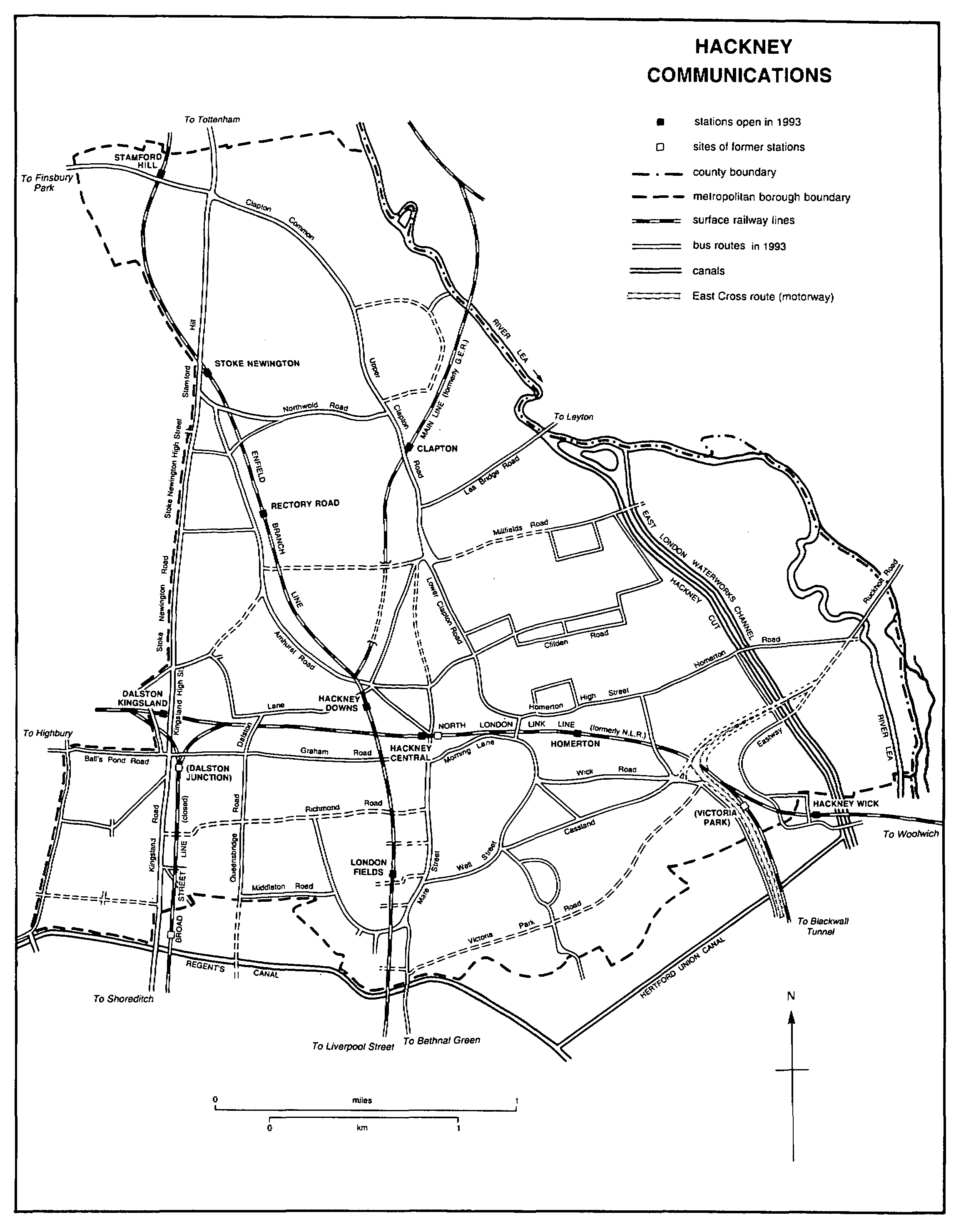
The East & West India Docks & Birmingham Junction Railway was authorized in 1846 primarily for the conveyance of goods for the London & North Western Railway (L.N.W.R.) from Camden Town to Blackwall by way of Islington, Hackney, and Bow. (fn. 113) Land was acquired in 1847 (fn. 114) but construction was slow; in 1850, before the line had reached the docks, a passenger service ran every 15 minutes by the circuitous route from Islington to Fenchurch Street, with stations called Kingsland, Hackney, and from 1856 Victoria Park (Hackney Wick). The company, renamed the North London Railway (N.L.R.) in 1853, came to be dominated by the L.N.W.R., which took over its working in 1909 and formally absorbed it in 1922, itself becoming part of the L.M.S. in 1923. From 1854 Victoria Park was linked by the Eastern Counties Railway with Stratford and the main line of that company, from 1862 the Great Eastern Railway (G.E.R.), to Cambridge, Ipswich, and Norwich.
In 1865 the N.L.R. provided a shorter link with the City. From Broad Street the line, built at great expense through crowded Shoreditch, ran close to the east side of Kingsland Road to Dalston Junction station, whence the tracks branched north-east and north-west to join the older line through Hackney. Kingsland station, directly north of Dalston Junction, was closed. Later improvements by the N.L.R. included the resiting of Victoria Park (Hackney Wick) station in 1866, the opening of Homerton station in 1868, and the removal of Hackney station from the- east to the west side of Mare Street in 1870. The stretch from Broad Street to Dalston did much to open the northern suburbs to commuters; workmen's fares were available and it soon had one of London's heaviest traffic flows, with 322 trains terminating on weekdays at Broad Street in 1903. (fn. 115)
A northward branch from the G.E.R.'s main line at Bethnal Green, itself to be extended from Shoreditch to a new terminus at Liverpool Street, was authorized in 1864. The branch was opened in 1872, with stations at London Fields and Hackney Downs Junction (later known simply as Hackney Downs), where it divided. The north-westerly or Enfield branch ran to join an existing line at Edmonton, with stations at Rectory Road, Stoke Newington, and Stamford Hill. The north-easterly branch curved across the Lea to Walthamstow, connecting with the main Cambridge line, and in 1873 to Chingford, through a tunnel under Hackney Downs and a station at Clapton. Trains for Cambridge were later diverted from Stratford to the Hackney Downs route, which became part of the L.N.E.R. in 1923. (fn. 116)
The stretch of the original N.L.R. line between Dalston eastern and western junctions was used only intermittently until 1914 for passenger traffic after the closure of Kingsland station; it continued to be used for goods. Passenger services to the east ceased in 1944 with the closure of Hackney and Homerton stations, which had been preceded by closures at Victoria Park in 1942 and 1943. (fn. 117) On the Enfield branch line Stoke Newington station was rebuilt as a plain glass and steel box in 1975; (fn. 118) Rectory Road station was also rebuilt, in brick. New stations called Hackney Central and Hackney Wick (a resiting of Victoria Park) were opened in 1980 as part of the North London Link line, revived by British Rail with help from the G.L.C. (fn. 119) The entire line from North Woolwich to Richmond was reopened for electric trains in 1985, with stations at Hackney Wick, Homerton, Hackney Central, and Dalston Kingsland; (fn. 120) a south-west curve at Graham Road, by which trains from Richmond could reach Liverpool Street, was also opened in 1985 but later closed. The Broad Street line and Dalston Junction station were closed in 1986 and the track was taken up, (fn. 121) although the route had not been built upon in 1990.
No Underground railways served Hackney M.B., despite its size. Two lines from the City were projected in 1901, the North East London to Stoke Newington and the City & North East Suburban by way of Victoria Park to Walthamstow, but both failed in Parliament in 1902. (fn. 122) The nearest Underground stations were at Essex Road and Highbury, to the west, (fn. 123) from 1904 and at the Victoria line's Seven Sisters, to the north, from 1968. (fn. 124)